
4.6: South America- The Urban North and Andean West (1 Day)
- Page ID
- 1965
- Describe the dynamics of Venezuela’s urban society and why Venezuela has not experienced a robust rural-to-urban shift to the extent that other countries have.
- List the production of the three main export products of Colombia and explain the US role in their export.
- Compare the three main countries in the Andean West region of South America and understand how they gained their wealth and who has benefited the most over the years from that wealth.
- Summarize how Paraguay’s geographical setting has allowed it to gain wealth and provide opportunities for its people.
TEKS Regional Unit 04: Chapter 4.6 The Urban North and Andean West
WG.7D Examine benefits and challenges of globalization, including connectivity, standard of living, pandemics, and loss of local culture.
WG.11A Understand the connections between levels of development and economic activities (primary, secondary, tertiary, and quaternary).
WG.11B Identify the factors affecting the location of different types of economic activities, including subsistence and commercial agriculture, manufacturing, and service industries
WG.11C Assess how changes in climate, resources, and infrastructure (technology, transportation, and communication) affect the location and patterns of economic activities.
WG.12A Analyze how the creation, distribution, and management of key natural resources affects the location and patterns of movement of products, money, and people.
WG.13A Interpret maps to explain the division of land, including man-made and natural borders, into separate political units such as cities, states, or countries.
WG.16D Compare life in a variety of urban and rural areas in the world to evaluate political, economic, social, and environmental changes.
WG.17A Describe and compare patterns of culture such as language, religion, land use, education, and customs that make specific regions of the world distinctive.
WG.17B Assess causes, effects, and perceptions of conflicts between groups of people, including modern genocides and terrorism.
WG.17C Compare economic, political, or social opportunities in different cultures for women, ethnic and religious minorities, and other underrepresented populations.
WG.17D Evaluate the experiences and contributions of diverse groups to multicultural societies.
WG.18A Analyze cultural changes in specific regions caused by migration, war, trade, innovations, and diffusion.
WG.20B Examine the economic, environmental, and social effects of technology such as medical advancements or changing trade patterns on societies at different levels of development.
WG.22A Design and draw appropriate graphics such as maps, diagrams, tables, and graphs to communicate geographic features, distributions, and relationships.
WG.22C Use geographic terminology correctly.
WG.22D Use standard grammar, spelling, sentence structure, and punctuation.
TEKS and ELPS for Regional World Geography Unit 04--Latin America from TEKS Resource System
South America: The Urban North and Andean West
Venezuela: Oil, Politics, and Globalization
Bordering the Caribbean is the large urban country of Venezuela. The Andes Mountains reach into the northern part of the country and make up the terrain of the northern coastal region all the way to the capital city of Caracas. The large grassland plains of the Llanos extend farther south from the Colombian border to the Orinoco River delta. The Llanos is a large, sparsely populated region that makes up about one-third of the country. It is remote, susceptible to flooding, and used mainly for raising cattle.
In the southeast of Venezuela are the Guiana Highlands, which make for a spectacular physical landscape of tropical forests and rugged mountainous terrain. The highlands include Angel Falls, the tallest waterfall in the world. Angel Falls drops 2,647 feet and is Venezuela’s most popular tourist attraction. Lake Maracaibo, the large inland sea located in the western region of the country, is not a true lake in that it is open to the Caribbean Sea. Lake Titicaca, located in the Andean region of the Altiplano on the border between Peru and Bolivia, is considered the continent’s largest freshwater lake.
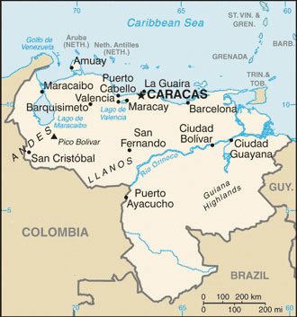
Notice that most of the main cities are located along the northern coast.
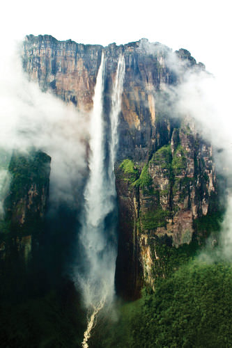
The total falls is estimated at 3,212 feet. The largest free fall is estimated to be about 2,647 feet, which is about one-half a mile. Angel Falls is the country’s number one tourist attraction.
Venezuela has an assortment of physical regions, but most of the population lives along the northern coast. About 90 percent live in urban areas, and the capital Caracas has the highest population. Less than 5 percent of the population lives south of the Orinoco River. Amerindian groups live in the interior and along the river.
Included in the Mixed Mestizo Cultural Region, Venezuela has a heavy Spanish influence laid over an Amerindian base in a plantation region known for its African infusion. There is also a strong Caribbean cultural flavor, which is evident in the region’s music and lifestyle. The official language is Spanish, but more than 30 indigenous languages are still spoken in the country.
Venezuela gained its independence from Spain in 1821 and has developed into an urban country with an economy based on oil production. A large extent of the interior is undeveloped. Venezuela does not have extensively developed agricultural production, so most food is imported. Lake Maracaibo has vast oil reserves beneath it that have provided substantial wealth to the country.
As much as 90 percent of Venezuela’s export earnings are from the export of oil. Venezuela’s national oil company, CITGO, has made extensive inroads into the US gas station market. The country was one of the founding members of OPEC (Organization of Petroleum Exporting Countries), which is usually associated with the oil-rich states of the Persian Gulf. In the past decade, Venezuela has been one of the top five countries exporting oil to the United States. The other four are Canada, Mexico, Saudi Arabia, and Nigeria.
As is the case with many countries, national wealth in Venezuela does not trickle down to most of the population. The wealthy elite who have benefited the most from the nation’s wealth often finds themselves on the opposite side of the political debate from the majority, who are likely to live in poor conditions. Caracas has many upscale neighborhoods, but it also has a large number of slums on the outskirts of the city. Slums in South America go by different names, such as barrios in Venezuela or favelas in Brazil. Many of Venezuela’s barrios are built on the mountainsides of the Andes.
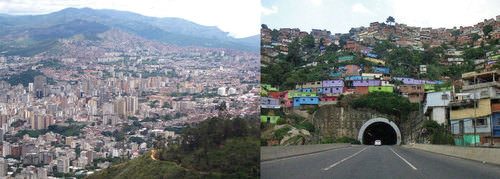
The photo on the left is of the main urban core, with upscale neighborhoods. The photo on the right is a barrio located on a steep mountainside. Barrios are usually self-constructed slum areas and are similar to favelas in Brazil.
Exporting oil to the United States does not mean that the relations between the United States and Venezuela are friendly. There has been some political unrest within the country related to the current president, Hugo Chavez, who holds continuous terms in office without term limits. President Chavez has held close ties with socialist Cuba and with the Castro regime. From time to time, his rhetoric has been antagonistic toward the United States. This situation has caused concern within the US political establishment with regard to the position that the United States takes toward Venezuela. Nevertheless, the United States remains Venezuela’s number one trading partner in both imports and exports.
Politics in Venezuela often plays the wealthy elites against the poorer majority, and President Chavez has not been an exception. Chavez has supported socialist political leaders from other Latin American states and has pushed a globalization agenda along the same lines. The country’s enormous oil revenues and its current political climate have increased Venezuela’s visibility in the global arena. How this will play out over the long term is unclear.
In the past, Latin America has had a greater number of elected political leaders with more progressive or socialist views. These trends continue to shape the economic trade agreements between countries. Venezuela has been working to increase sales of oil to countries in Mercosur (the Southern Cone Common Market), which is the most significant trade association in South America.
Globalization is also evident in Venezuela’s cultural and social dynamics. In many Latin American countries, soccer is the most popular sport. However, Venezuela’s favorite sport is baseball because of the influence of early US activity in the country’s oil industry. Soccer is gaining attention and support; however, orchestras and classical music performances have also gained notoriety in recent years. Concert halls from the Americas to Europe have experienced the performances of the Simón Bolívar Youth Orchestra. The Miss Venezuela pageant is a major production for the country, and Venezuela has won the top title at least five times in each of the following pageants: Miss World, Miss Universe, and Miss International.
Colombia: Drugs, Coffee, and Oil
Three ranges of the Andes Mountains run from north to south through Colombia, which is larger than the nine most southeastern US states. With a land area covering about 440,839 square miles, Colombia is more than ten times larger than the US state of Indiana and close to twice the size of France. Colombia borders five countries, with the Caribbean to the north, the Pacific Ocean to the west, the Orinoco River to the east, and a short segment of the Amazon River to the far south. Even though agriculture has been a mainstay of the country’s economic activities, because of the influence of the mountainous terrain, about 75 percent of the population lives in urban areas.
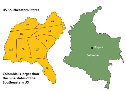 This map compares the physical size of Columbia with nine states in the southeastern United States.
Colombia was a Spanish colony during the time that Spain controlled most of western South America. Colombia became independent in 1819. The region of Panama, which was first a part of Colombia, broke away in 1903 when the United States backed Panama’s independence movement. After Colombia became independent of Spain, the conservatives (wealthy elite) and the liberals (poor workers) struggled to gain control of the government. Since 1948, the conflict, known as La Violencia, has caused more than 200,000 casualties. During the 20th century, the government in Colombia has not always been peaceful or stable. By the beginning of the 21st century, the government has become more unified and the country has witnessed an increase in tourism.
Colombia and the Drug Trade
Colombia’s tropical climate and its many remote areas contributed to its development as a major coca-growing region. By the 1970s, extensive drug smuggling had developed, and powerful drug cartels became major political brokers within the country, competing against the government for control of Colombia. The largest and most organized cartels operated out of Medellin and Cali, the second and third largest cities in the country after the capital city of Bogotá.
The coca plant grows throughout the slopes of the Andes, from Colombia to Bolivia. Historically, locals have chewed it or brewed it into tea. Coca can alleviate elevation sickness and act as a mild stimulant. Using modern methods and strong chemicals, the coca leaves can be converted into a powerful narcotic. It often takes up to a ton of chemicals to produce a kilo of cocaine. Once the process is completed, most of the chemicals are discarded and frequently find their way into nearby rivers and streams, which are the same water supplies that local people use in their daily lives. Birth defects have become a problem in coca-growing regions because of the high levels of chemical pollution in the water.
The largest cocaine market is with the United States. Secret airfields and private boats transport the cocaine from Colombia to distribution centers in Mexico, Central America, or the Caribbean. From there, the drugs are smuggled into the United States. Colombian drugs are a multibillion-dollar industry that makes up a large portion of the Colombian economy. The effect of the drug industry on the people of Colombia is extensive—from the gunfire on the streets to the corruption of government officials.
In recent years, the same drug cartels that have operated the cocaine industry have imported opium poppies, which grow well on the higher and more arid slopes of the Andes. Opium poppies are native to Asia but have been transported to South America. Opium is extracted from the seedpod and can be further refined into heroin. Colombian drug cartels, with a Mexican distribution network, have gained as much as 20 percent of the US heroin market. The US government has supported the Colombian government in the fight against the drug cartels and the trafficking of illegal drugs out of Colombia.
Colombian Coffee and Oil
Colombia’s two main legal exports to the United States are coffee and oil. Coffee is only grown in the tropics since coffee trees must be grown in a frost-free environment. Coffee trees, which originally grew in Ethiopia, have since been grown throughout the world. Coffee trees can grow in elevations from sea level to 6,000 feet, but most of the best specialty coffee is grown at elevations between 3,000 to 6,000 feet. Colombia has ideal conditions for growing coffee and was once the world’s largest coffee producer; now Brazil and Vietnam each produce more.
Early coffee production in Colombia was initially promoted by Catholic priests who were influential in supporting local parishioners to grow the crop. The industry was greatly enhanced in 1927 with the formation of the National Federation of Coffee Growers of Colombia. Coffee production on the mountain ranges of the Andes in Colombia supports up to 500,000 small farms and local growers that make up a large portion of the coffee economy. Harvesting coffee is labor intensive and can employ large numbers of workers. The seasonal nature of the harvest also leaves workers to find employment during the rest of the growing season.
In recent years, there has been growing concern about how climate change will continue to affect the region’s coffee production. In the past century, parts of Colombia experienced up to a 1 ºC average temperature increase and up to a 25 percent increase in precipitation. These climate changes have negatively impacted coffee output and reduced coffee production as much as 25 percent in some areas. New agricultural methods are being developed in an attempt to counter the decrease.
Oil has now become Colombia’s number one legal export. Oil is found in fields in the northern and central regions of Colombia. Immense quantities of coal are also found in the same regions, but oil is more valued in the export market. Pipelines connect the interior oil fields of Colombia with the northern ports. The US market size and population make it the world’s largest oil consumer.
US oil companies have been investing in the development of Colombian oil for many years. Colombia has been a developing oil source even though its total extractable resources are not as vast as in other countries. For example, in 2006, the United States imported more oil from Colombia than from Kuwait, Oman, the United Arab Emirates (UAE), Bahrain, Qatar, and Yemen combined.
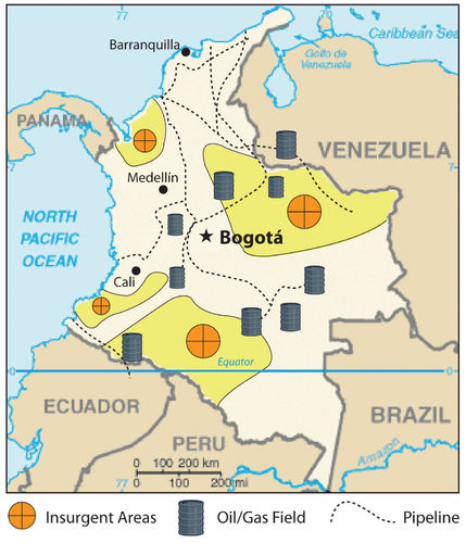
Insurgent groups control regions in Colombia as large as US states.
Since the United States is the largest consumer of Colombian oil, it has a vested interest in the stability of the Colombian government. A sizable portion of Colombia is controlled by drug cartels or other insurgent groups. Dozens of guerrilla organizations also control portions of Colombia. Some insurgent groups support the government and are against the drug lords, while others fight the government and work independently or with the cartels.
Drug sales, kidnappings, and extortion of legitimate businesses provide income to these groups. Thousands of children serve in these groups, and about one-third of them are female. The most powerful insurgent group is FARC (Revolutionary Armed Forces of Colombia), which controls entire regions the size of many US states. FARC is a recognized political entity by neighboring countries but is not given the same recognition by the United States and other countries of the region.
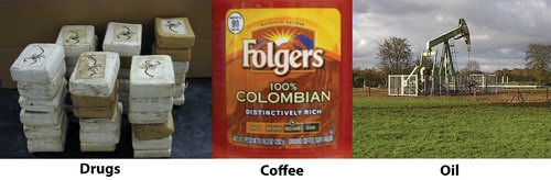
The three main export products of Colombia are illegal drugs, oil, and coffee. The United States is the largest consumer of all three.
The relationship between Colombia and the United States is conflicted. The US consumer supports the Colombian drug cartels by being the largest consumer of illegal drugs. The US government, under the Drug Enforcement Administration (DEA), has declared a war on drugs. The US has supported the Colombian government with billions of dollars in foreign aid to fight that war.
On another front, US oil corporations have paid insurgent groups to protect their oil assets. Oil is exported to the United States, bringing billions of dollars into the Colombian economy. The chaos in Colombia is directly related to the exploitation and marketing of titsresources. It is the people of Colombia who are the collateral damage in this civil war of corruption, crime, death, and destruction. The largest consumer market for Colombia’s export of oil, drugs, and coffee is the United States, which is also the largest contributor of foreign aid to Colombia.
Rural Amerindian States of Ecuador, Peru, and Bolivia
The Central Andes, which includes Ecuador, Peru, and Bolivia, were home to the Inca Empire. The empire had gone through some internal divisions and was working on unifying the region when Francisco Pizarro’s small army defeated the Incan warriors and brought about colonial rule beginning in the 1530s. Many cultures lived in the Central Andes before the Inca. Their legacy can be seen in the culture of the Amerindian people who still live there today.
Spanish is the official language, but indigenous languages are widely spoken in the rural areas and remote villages. Ecuador, Peru, and Bolivia make up the core of the Rural Amerindian Region of South America. There have been border disputes among the three countries, and also with their neighbors. Nevertheless, they all share the Andes and have many things in common.
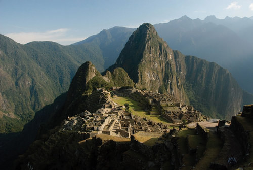
The ruins are located at about 7,970 feet in elevation and are surrounded by higher peaks of the Andes.
Physical Geography
The physical geography of the Central Andes includes more than the Andes Mountains. The coastal region to the west of the Andes is generally warmer than the cooler climate of the mountains. The equatorial region is humid. The coastal region in southern Peru is dry and arid because of the ocean currents and the rain shadow effect of the Andes, which creates the Atacama Desert that extends up from northern Chile. Southwest Bolivia has some of the world’s largest salt flats in this dry and barren region.
In the interior, on the eastern side of the mountain range, is the huge expanse of the Amazon Basin. The climate is tropical and humid with heavy precipitation. Rain forests and jungle fauna can be found on the eastern slopes. The Altiplano region has the high-elevation Lake Titicaca. The variations in physical terrain provide extensive biodiversity in animal and plant species. It also supports a variety of economic activities to profit from the bountiful natural resources.
Even though the Altiplano region borders the Pacific Ocean, it also links directly to the Atlantic Ocean. The headwaters that create the Amazon River start in Peru. By the time the water reaches the Peruvian city of Iquitos, the river is large enough to accommodate large shipping vessels. Iquitos is a port city for the Atlantic Ocean with access to Europe, Africa, and eastern North America. The port also links the region with Brazil’s free-trade zone in Manaus, which has access to large oceangoing shipping and an international market.
Economic Geography
The region’s main income comes from exports of minerals, oil, and agricultural products. Oil is the number one means of gaining wealth in Ecuador and Peru. Natural gas is the number one export of Bolivia. Gold, silver, tin, and other minerals are also abundant and are being exploited as conditions allow. The Spanish opened up a large silver-mining operation in Potosí, Bolivia, which continues to be exploited with modern mining methods. Potosí, one of the earth’s highest-elevation cities at 13,420 feet above sea level, was once the largest silver mine in the world.
The city of Lima, Peru, was built on wealth from gold and silver extracted from the Inca Empire and the Andes Mountains. As is the case in many peripheral regions, the economic state of Peru, Ecuador, and Bolivia is dependent on global prices for their export products. There has been considerable conflict and political wrangling about who controls the wealth from extractive economic activities.
Originally, the Spanish conquistadors took the materials and the wealth. They were replaced by Mestizo land owners and wealthy elites who struck deals with international corporations. The corporations exploited the countries’ natural resources, with little profit actually ending up in the hands of most of the people. These issues remain at the top of the political agendas in all three countries.
Poverty and the exploitation of natural resources usually result in environmental degradation. The area’s heavy reliance on oil and gas extraction to gain national wealth has come at a great cost to the environment. Many oil spills have caused oil to enter the freshwater supplies of local residents and pollute the rivers and streams of the Amazon Basin. Mining has traditionally devastated the land because large portions of earth are removed to extract the ore or mineral. Pollution is causing a loss of habitats and destroying ecosystems, and few measures are being taken to prevent it. Deforestation is being caused by the timber industry and by clearing for agriculture. Overgrazing and the removal of the trees leave the soil open to erosion.
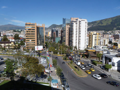
Quito is at about 9,200 feet in elevation and is considered the 2nd-highest-elevation capital in the world after La Paz in Bolivia.
Tourism
Tourism is expanding for travelers to explore Incan and Pre-Incan sites. One of the main tourist attractions in Peru is the ancient city of Machu Picchu in the Andes. Ecuador’s major tourist attraction is the Galapagos Islands, which aided Charles Darwin in understanding natural selection and the evolutionary process. Bolivia has a number of ancient sites that predate the Inca and have become major tourism destinations. The ancient city of Tiahuanaco and Lake Titicaca are good examples.
Tourism can be a great source of income, but it can come at a cost to the environment. There is always a concern that high-traffic tourism sites like Machu Picchu can be degraded by the mass of people visiting the site. The term ecotourism has been used to indicate the activity of people traveling to experience and enjoy the natural world with an aim not to damage the environment in the process. The main objective is to make tourism sustainable, which promotes stewardship of the land and respect for its attractions.
Jonathan Tourtellot, director of the National Geographic Society’s Center for Sustainable Destinations, coined and prefers the term geo-tourism, which is translated as the stewardship of place and the preservation of its essential character. These concepts are becoming more integrated in the tourism industry to promote a sustainable model for high traffic sites like the Galapagos Islands with fragile ecosystems.
Political Issues
Economics usually drive politics. Accordingly, Peru, Ecuador, and Bolivia have suffered with fluctuations in their political environment. Corruption, authoritarianism, and human rights violations have been common accusations toward the political leadership of these countries. To address the economic condition of his country in 2000, Ecuador’s president adopted the US dollar as its main medium of exchange. This may have brought some economic stability, but it did not address the problems of a high national debt and a fluctuation in commodity prices.
All three countries have undergone political turmoil. Large percentages of the populations live in poverty. Bolivia is considered one of the poorest countries in South America. In 2006, Bolivia elected a socialist president from the MAS (Movement for Socialism) party who was from a minority Amerindian group rather than a member of the wealthy elite. In Peru, a number of presidents have been forced to resign, and military coups have also resulted in leadership changes.
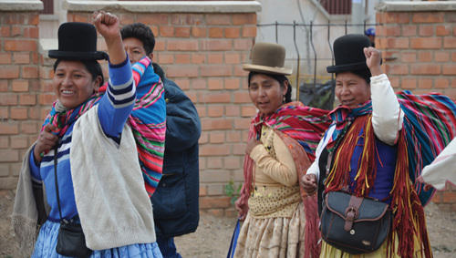
MAS is the Movement for Socialism, which has been active in Bolivian politics.
Population and Culture
Population growth is a major factor in the future of Peru, Ecuador, and Bolivia. In 2010, Bolivia had more than 10 million people, Ecuador had more than 14 million, and Peru had about 29 million. More than 30 percent of the population of Ecuador and Bolivia resides in rural areas and make a living from subsistence agriculture. All three countries have large populations in relation to food production. Peru and Bolivia are large countries in a physical area but do not have a high percentage of arable land. The rural-to-urban shift is increasing and the major cities are continuing to expand, overtaxing public works and social services.
The culture of the Central Andes is heavily influenced by its rural Amerindian heritage. The foundation of the traditional agrarian society has been subsistence agriculture. One-third of the population in Ecuador and Bolivia and up to one-fourth of the population in Peru continue to live a traditional way of life. Local cuisine reflects the connection to the land, and food such as potatoes, maize, guinea pigs, and fish are common in rural areas. Cities are encountering international influences that are changing the demands in local cuisine and culture. However, traditional food, arts, and local crafts still thrive in the local districts and in the tourism market.
The Andean West and Paraguay
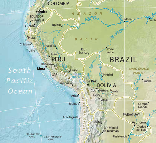
This map also displays a part of the Amazon Basin, the Atacama Desert, Altiplano, and the Mato Grosso Plateau.
This region’s location on the Pacific Rim of South America has contributed to an Asian influence, which has integrated with the local culture. Former president of Peru Alberto Fujimori had Japanese ancestry and held dual citizenship in both Peru and Japan. Lima, Peru is home to one of the earliest Chinatowns in the Americas, where the Chinese culture has mixed with the Latino culture to create a unique cultural blend. Bolivia is landlocked and does not have the advantage of a west-coast port city to interact with the Asian marketplace. However, its culture is still impacted by globalization and is evolving from within.
Paraguay
Paraguay is located in the Mixed Mestizo Cultural Region between Brazil, Argentina, and Bolivia. This landlocked country is not located in the Andes. The country’s poor economic characteristics and troublesome political dynamics are similar to those of its neighbors in the Central Andes. Like other Latin American countries, most of the population practices Catholicism. Spanish is one of the main languages along with Guarani, the local language of the people.
The country’s name comes from the Paraguay River, which flows through hydroelectric dams that provide all the electricity for the country. Paraguay suffers from a lack of infrastructure. The government has not been able to provide for the needs of a growing population with a fertility rate of more than three children per family.
As much as 40 percent of the population makes its living from agriculture. However, conditions in the rural areas are poor, and less than 10 percent of the land is arable. There is not much agricultural growth that could boost the economy. Paraguay is the 6th-largest producer of soybeans in the world, and cattle ranching is its other strong commodity. A large portion of the marshlands have been turned into land for farming, but this has caused a loss of wetlands as a habitat.
Poverty afflicts the region and results in the absence of opportunities and advantages. Connections to global markets are hindered by the lack of an international port. Corruption and unstable governments are the political system’s legacy. There is a wide disparity between the social elites and most of the population. Large family size and the rural-to-urban shift has caused rapid growth of the urban areas. Sixty percent of the population lives in the cities, and they often suffer from unsanitary conditions because of water pollution.
The largest slums in the country are found in the capital city of Asuncion, which has almost two million people. In the urban areas, there is a strong informal market economy that thrives on imported goods being redistributed to other countries, but there is no formal record-keeping system. An enormous number of black-market goods are brought in and resold to neighboring countries such as Brazil and Argentina, its two largest trading partners. In such conditions, crime and illegal activities thrive, and the rule of law is difficult to enforce.
- Most of the people in Venezuela live in cities along the Caribbean coast.
- Venezuela has always been urban and does not have an agricultural economy.
- Venezuela depends on oil exports for its national wealth.
- The United States is the largest consumer of products exported from Colombia.
- Illegal drugs, oil, and coffee and are the three main export products of Colombia.
- The United States directly or indirectly supports the three main exports of Columbia.
- The Andean countries of Ecuador, Peru, and Bolivia share similar developmental dynamics, including a large percentage of Amerindian people and reliance on the export of natural resources to gain national wealth.
- The wealth gained from the exports of Ecuador, Peru, and Bolivia is concentrated in the hands of the social elites.
- Paraguay is a landlocked country between the Andes and the Atlantic coast.
- Paraguay is a poor nation with few opportunities to advance its standard of living.
- Paraguay has been a main staging ground for unregulated goods to be redistributed throughout the region.
Vocabulary Terms
| Machu Picchu | A city built by the Inca as a retreat for Incan kings and serves as the finest example of Inca architecture |
| Quecha | official language of Incas; still spoken by people of Peru |
| Terraced farming | a farming system that is in the form of steps going up a mountain used by both the Aztecs and Inca |
Applying Knowledge
Interactive Notebook Activity
- Describe the dynamics of Venezuela’s urban society and explain why Venezuela has not experienced a robust rural-to-urban shift to the extent that other countries have.
- List the production of the three main export products of Colombia and explain the role of the United States in their export.
- Compare the three main countries in the Andean West region of South America. Explain how they gained their wealth and who has benefited the most over the years from that wealth.
- Summarize how Paraguay’s geographical setting has allowed it to gain wealth and provide opportunities for its people.
Discussion and Study Questions
- How intense is the current rural-to-urban shift in Venezuela? What accounts for this unique situation?
- What are the three main export products of Colombia? How is the United States involved in each of them?
- Where are the main types of coffee grown?
- What three groups vie for control of the various regions of Colombia? How does the United States directly or indirectly support all three groups?
- What environmental problems result from the cocaine production process?
- How did colonial activity assist in determining which ethnic group or groups would be at the top or bottom of the socioeconomic hierarchy in the Andean West region of South America?
- What are some of the common difficulties with the political systems of the countries in the Andean West?
- What does Paraguay have in common with Bolivia? How have the two countries each addressed this common situation?
- Where has socialism been promoted or supported in the countries of South America?
- What types of agriculture are found in the north and western regions of South America?
Real-World Geography Exercise
- Using Google Maps, complete the following activities:
- Locate each place on the bulleted list below.
- Find the nearest city with an international airport in proximity to each location on the bulleted list below.
- Calculate the distance and travel time by plane to each city from the San Francisco International Airport in San Francisco, California.
- Using NASA Latitude and Longitude Finder, determine the latitude and longitude for each location on the bulleted list below.
- Be prepared to share and discuss your answers.
- Iguazu Falls, Argentia/Brazil
- Salar de Uyuni, Bolivia
- Galapagos Islands, Ecuador
- Atacama Desert, Chile
- Angel Falls, Venezuela
- Torres del Paine, Chile
- Colca Canyon, Peru
- Lake Titicaca, Peru/Bolivia
- Perito Moreno Glacier, Argentina
- Laguna Colorada, Bolivia
- Aconcagua, Argentina
- Kaietuer Falls, Guyana
- Tierra del Fuego, Argentina
Mapping Exercise
Tropical Deforestation: Students will identify and describe the locations most affected by deforestation.
Urban Areas and Edge Cities: Students will explore urban areas around the world, including their layout, size, and other factors. The activity uses a web-based map.
Videos for Geography Enrichment
Helpful Websites for the Study of Geography
Canadian Encyclopedia is an encyclopedia funded by the Canadian government covering all branches of knowledge. Their scholarly collection includes interactive materials.
CIA World Factbook provides information on the people, history, government, economy, energy, geography, communications, transportation, military, and transnational issues for the world's entities.
Congress.gov is a US government website where you can find federal legislation, past and present, as well as information about the US legal system.
Drug Enforcement Administration (DEA) is a government agency website that provides current news, resources, topics of interest, information about drugs, careers in the DEA, and a tip hotline.
Library of Congress is the largest library in the world and provides manuscripts, files, information, pictures, and videos.
NASA Earth Observatory (NEO) is a US government agency website that allows users to search for and retrieve satellite images of Earth.
National Archives is a US government website that provides historical documents, photos, records, publications, and educator resources.
National Oceanic and Atmospheric Association (NOAA) is a US government agency website that provides weather-related information and ocean research.
National Map is a website by the United States Geological Survey and other federal, state, and local agencies that delivers topographic information for the United States.
NationMaster is a massive central data source and a handy way to graphically compare nations.
Real-Time World Air Quality Index is a website that measures most locations in the world for air pollution in real time.
StateMaster is a unique statistical database, which allows you to research and compare a multitude of different data on US states.
United Nations (UN) is an international organization founded in 1945 and made up of 193 member states. The UN maintains international peace and security, protects human rights, delivers humanitarian aid, promotes sustainable development, and upholds international law.
United States Census Bureau is a US government agency that provides a population clock, data, surveys, statistics, a library with information and infographics, news about the economy, and much more.
United States Geological Survey (USGS) is a US government agency website that provides scientific information about the natural hazards that threaten lives, the natural resources we rely on, the health of our ecosystems and environment, and the impacts of climate and land-use change.
Whitehouse.gov is a US government website that provides the latest presidential news, information about the budget, policy, defense, and many more topics.
World Health Organization (WHO) is under the United Nations and provides leadership on matters critical to health, shapes the research agenda on health, and monitors the health situation and assessing health trends around the world. Their website provides information on the state of health around the world, outbreaks, current health news, and more.
World Trade Organization (WTO) is an intergovernmental organization that regulates international trade. The website provides information on the history of the multilateral trading system, featured videos, news and events, trade topics, and more.
| Image | Reference | Attributions |
|
[Figure 1] | Credit: CIA World Factbook – public domain. Source: open.lib.umn.edu/worldgeography/wp-content/uploads/sites/181/2016/04/3e9e95dfabccf7df0c5e07da222ebfe6.jpg License: CC BY-NC 3.0 |
|
[Figure 2] | Credit: Inti – El Sato Angel – CC BY 2.0. Source: open.lib.umn.edu/worldgeography/wp-content/uploads/sites/181/2016/04/54af449a2c8fd00fd358e4cb3b58761c.jpg License: CC BY-NC 3.0 |
|
[Figure 3] | Credit: Cristóbal Alvarado Minic – Vista de Caracas – CC BY 2.0; Danila Medvedev – A tunnel and barrios surrounding it on the hill – CC BY 2.0. Source: open.lib.umn.edu/worldgeography/wp-content/uploads/sites/181/2016/04/124c11ad79479e6d1941a838a6b93565.jpg License: CC BY-NC 3.0 |
|
[Figure 4] | Credit: http://open.lib.umn.edu/worldgeograp...d-andean-west/ Source: open.lib.umn.edu/worldgeography/wp-content/uploads/sites/181/2016/04/7c8fa712b7978464c0681c5e15396c36.jpg License: CC BY-NC 3.0 |
|
[Figure 5] | Credit: CIA World Factbook – public domain. Source: open.lib.umn.edu/worldgeography/wp-content/uploads/sites/181/2016/04/c915afaf31d4d82af02fed8f7cdb1f36.jpg License: CC BY-NC 3.0 |
|
[Figure 6] | Credit: DEA – public domain; R. Berglee – CC BY-NC-SA; Wikimedia Commons – public domain. Source: open.lib.umn.edu/worldgeography/wp-content/uploads/sites/181/2016/04/fcf859e31ac0fb1418b26477a31963c3.jpg License: CC BY-NC 3.0 |
|
[Figure 7] | Credit: Funkz – Machu Picchu 12 – CC BY 2.0. Source: open.lib.umn.edu/worldgeography/wp-content/uploads/sites/181/2016/04/44d09b985e4404e5d32de3f4f4b2ef3d.jpg License: CC BY-NC 3.0 |
|
[Figure 8] | Credit: David Berkowitz – Panoramic View – Quito, Ecuador – South America – CC BY 2.0. Source: open.lib.umn.edu/worldgeography/wp-content/uploads/sites/181/2016/04/b42bea36a995cc31b4104f7d38fc45e7.jpg License: CC BY-NC 3.0 |
|
[Figure 9] | Credit: Norsk Folkehjelp Norwegian – Urfolk i Bolivia – CC BY 2.0. Source: open.lib.umn.edu/worldgeography/wp-content/uploads/sites/181/2016/04/c5a21d7b423cf803d319decb370f6a75.jpg License: CC BY-NC 3.0 |
|
[Figure 10] | Credit: University of Texas Libraries. Source: open.lib.umn.edu/worldgeography/wp-content/uploads/sites/181/2016/04/ace9269cb839a5ccdadd366e45dfad20.jpg License: CC BY-NC 3.0 |