
4.2: Mexico (2 Days)
- Page ID
- 1958
\( \newcommand{\vecs}[1]{\overset { \scriptstyle \rightharpoonup} {\mathbf{#1}} } \)
\( \newcommand{\vecd}[1]{\overset{-\!-\!\rightharpoonup}{\vphantom{a}\smash {#1}}} \)
\( \newcommand{\dsum}{\displaystyle\sum\limits} \)
\( \newcommand{\dint}{\displaystyle\int\limits} \)
\( \newcommand{\dlim}{\displaystyle\lim\limits} \)
\( \newcommand{\id}{\mathrm{id}}\) \( \newcommand{\Span}{\mathrm{span}}\)
( \newcommand{\kernel}{\mathrm{null}\,}\) \( \newcommand{\range}{\mathrm{range}\,}\)
\( \newcommand{\RealPart}{\mathrm{Re}}\) \( \newcommand{\ImaginaryPart}{\mathrm{Im}}\)
\( \newcommand{\Argument}{\mathrm{Arg}}\) \( \newcommand{\norm}[1]{\| #1 \|}\)
\( \newcommand{\inner}[2]{\langle #1, #2 \rangle}\)
\( \newcommand{\Span}{\mathrm{span}}\)
\( \newcommand{\id}{\mathrm{id}}\)
\( \newcommand{\Span}{\mathrm{span}}\)
\( \newcommand{\kernel}{\mathrm{null}\,}\)
\( \newcommand{\range}{\mathrm{range}\,}\)
\( \newcommand{\RealPart}{\mathrm{Re}}\)
\( \newcommand{\ImaginaryPart}{\mathrm{Im}}\)
\( \newcommand{\Argument}{\mathrm{Arg}}\)
\( \newcommand{\norm}[1]{\| #1 \|}\)
\( \newcommand{\inner}[2]{\langle #1, #2 \rangle}\)
\( \newcommand{\Span}{\mathrm{span}}\) \( \newcommand{\AA}{\unicode[.8,0]{x212B}}\)
\( \newcommand{\vectorA}[1]{\vec{#1}} % arrow\)
\( \newcommand{\vectorAt}[1]{\vec{\text{#1}}} % arrow\)
\( \newcommand{\vectorB}[1]{\overset { \scriptstyle \rightharpoonup} {\mathbf{#1}} } \)
\( \newcommand{\vectorC}[1]{\textbf{#1}} \)
\( \newcommand{\vectorD}[1]{\overrightarrow{#1}} \)
\( \newcommand{\vectorDt}[1]{\overrightarrow{\text{#1}}} \)
\( \newcommand{\vectE}[1]{\overset{-\!-\!\rightharpoonup}{\vphantom{a}\smash{\mathbf {#1}}}} \)
\( \newcommand{\vecs}[1]{\overset { \scriptstyle \rightharpoonup} {\mathbf{#1}} } \)
\(\newcommand{\longvect}{\overrightarrow}\)
\( \newcommand{\vecd}[1]{\overset{-\!-\!\rightharpoonup}{\vphantom{a}\smash {#1}}} \)
\(\newcommand{\avec}{\mathbf a}\) \(\newcommand{\bvec}{\mathbf b}\) \(\newcommand{\cvec}{\mathbf c}\) \(\newcommand{\dvec}{\mathbf d}\) \(\newcommand{\dtil}{\widetilde{\mathbf d}}\) \(\newcommand{\evec}{\mathbf e}\) \(\newcommand{\fvec}{\mathbf f}\) \(\newcommand{\nvec}{\mathbf n}\) \(\newcommand{\pvec}{\mathbf p}\) \(\newcommand{\qvec}{\mathbf q}\) \(\newcommand{\svec}{\mathbf s}\) \(\newcommand{\tvec}{\mathbf t}\) \(\newcommand{\uvec}{\mathbf u}\) \(\newcommand{\vvec}{\mathbf v}\) \(\newcommand{\wvec}{\mathbf w}\) \(\newcommand{\xvec}{\mathbf x}\) \(\newcommand{\yvec}{\mathbf y}\) \(\newcommand{\zvec}{\mathbf z}\) \(\newcommand{\rvec}{\mathbf r}\) \(\newcommand{\mvec}{\mathbf m}\) \(\newcommand{\zerovec}{\mathbf 0}\) \(\newcommand{\onevec}{\mathbf 1}\) \(\newcommand{\real}{\mathbb R}\) \(\newcommand{\twovec}[2]{\left[\begin{array}{r}#1 \\ #2 \end{array}\right]}\) \(\newcommand{\ctwovec}[2]{\left[\begin{array}{c}#1 \\ #2 \end{array}\right]}\) \(\newcommand{\threevec}[3]{\left[\begin{array}{r}#1 \\ #2 \\ #3 \end{array}\right]}\) \(\newcommand{\cthreevec}[3]{\left[\begin{array}{c}#1 \\ #2 \\ #3 \end{array}\right]}\) \(\newcommand{\fourvec}[4]{\left[\begin{array}{r}#1 \\ #2 \\ #3 \\ #4 \end{array}\right]}\) \(\newcommand{\cfourvec}[4]{\left[\begin{array}{c}#1 \\ #2 \\ #3 \\ #4 \end{array}\right]}\) \(\newcommand{\fivevec}[5]{\left[\begin{array}{r}#1 \\ #2 \\ #3 \\ #4 \\ #5 \\ \end{array}\right]}\) \(\newcommand{\cfivevec}[5]{\left[\begin{array}{c}#1 \\ #2 \\ #3 \\ #4 \\ #5 \\ \end{array}\right]}\) \(\newcommand{\mattwo}[4]{\left[\begin{array}{rr}#1 \amp #2 \\ #3 \amp #4 \\ \end{array}\right]}\) \(\newcommand{\laspan}[1]{\text{Span}\{#1\}}\) \(\newcommand{\bcal}{\cal B}\) \(\newcommand{\ccal}{\cal C}\) \(\newcommand{\scal}{\cal S}\) \(\newcommand{\wcal}{\cal W}\) \(\newcommand{\ecal}{\cal E}\) \(\newcommand{\coords}[2]{\left\{#1\right\}_{#2}}\) \(\newcommand{\gray}[1]{\color{gray}{#1}}\) \(\newcommand{\lgray}[1]{\color{lightgray}{#1}}\) \(\newcommand{\rank}{\operatorname{rank}}\) \(\newcommand{\row}{\text{Row}}\) \(\newcommand{\col}{\text{Col}}\) \(\renewcommand{\row}{\text{Row}}\) \(\newcommand{\nul}{\text{Nul}}\) \(\newcommand{\var}{\text{Var}}\) \(\newcommand{\corr}{\text{corr}}\) \(\newcommand{\len}[1]{\left|#1\right|}\) \(\newcommand{\bbar}{\overline{\bvec}}\) \(\newcommand{\bhat}{\widehat{\bvec}}\) \(\newcommand{\bperp}{\bvec^\perp}\) \(\newcommand{\xhat}{\widehat{\xvec}}\) \(\newcommand{\vhat}{\widehat{\vvec}}\) \(\newcommand{\uhat}{\widehat{\uvec}}\) \(\newcommand{\what}{\widehat{\wvec}}\) \(\newcommand{\Sighat}{\widehat{\Sigma}}\) \(\newcommand{\lt}{<}\) \(\newcommand{\gt}{>}\) \(\newcommand{\amp}{&}\) \(\definecolor{fillinmathshade}{gray}{0.9}\)- Describe the physical geography of Mexico, identifying the core and peripheral areas.
- Outline the socioeconomic classes in Mexico and explain the ethnic differences of each.
- Explain how the North American Free Trade Agreement (NAFTA) and maquiladoras have influenced the economic and employment situations in Mexico.
- Summarize in a few sentences how the drug cartels have become an integrated part of the Mexican economy and political situation.
TEKS Regional Unit 04; Latin America: Chapter 4.2 Mexico
WG.1A Analyze the effects of physical and human geographic patterns and processes on the past and describe their impact on the present, including significant physical features and environmental conditions that influenced migration patterns and shaped the distribution of culture groups today
WG.1B Trace the spatial diffusion of phenomena such as the Columbian Exchange or the diffusion of American popular culture and describe the effects on regions of contact
WG.2B Explain how changes in societies have led to diverse uses of physical features
WG.3B Describe the physical processes that affect the environments of regions, including weather, tectonic forces, erosion, and soil-building process.
WG.4A Explain how elevation, latitude, wind systems, ocean currents, position on a continent, and mountain barriers influence temperature, precipitation, and distribution of climate regions
WG.5A Analyze how the character of a place is related to its political, economic, social, and cultural elements
WG.5B Interpret political, economic, social, and demographic indicators (gross domestic product per capita, life expectancy, literacy, and infant mortality) to determine the level of development and standard of living in nations using the terms Human Development Index, less developed, newly industrialized, and more developed
WG.6B Explain the processes that have caused changes in settlement patterns, including urbanization, transportation, access to and availability of resources, and economic activities
WG.7B Explain how political, economic, social, and environmental push and pull factors and physical geography affect the routes and flows of human migration
WG.8B Describe the interaction between humans and the physical environment and analyze the consequences of extreme weather and other natural disasters such as El Niño, floods, tsunamis, and volcanoes.
WG.10C Compare the ways people satisfy their basic needs through the production of goods and services such as subsistence agriculture versus commercial agriculture or cottage industries versus commercial industries
WG.10D Compare global trade patterns over time and examine the implications of globalization, including outsourcing and free trade zones
WG.15A Identify and give examples of different points of view that influence the development of public policies and decision-making processes on local, state, national, and international levels
WG.22D Use standard grammar, spelling, sentence structure, and punctuation.
TEKS and ELPS for Regional World Geography Unit 04--Latin America from TEKS Resource System
Mexico's Physical Characteristics
Mexico is the 8th largest country in the world and about one-fifth the size of the United States. Bordered to the north by the United States, Mexico stretches south to Central America, where it is bordered by Guatemala and Belize. One of Mexico’s prominent geographical features is the world’s longest peninsula, the 775-mile-long Baja California Peninsula, which lies between the Pacific Ocean and the Gulf of California (also known as the Sea of Cortez). The Baja California Peninsula includes a series of mountain ranges called the Peninsular Ranges.
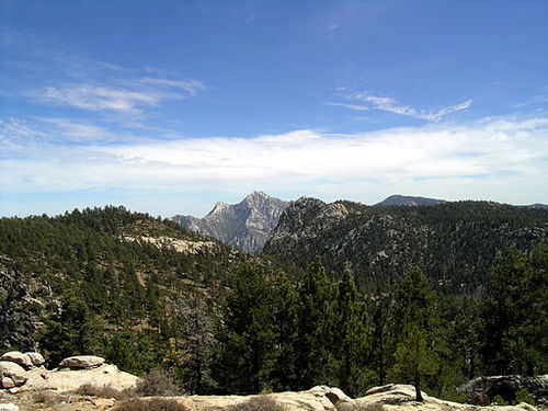 The Picacho del Diablo in the Sierra San Pedro Mártir mountain range of Baja California State, Mexico.
The Tropic of Cancer cuts across Mexico, dividing it into two different climatic zones: a temperate zone to the north and a tropical zone to the south. In the northern temperate zone, temperatures can be hot in the summer, often rising above 80 °F, but considerably cooler in the winter. By contrast, temperatures vary very little from season to season in the tropical zone, with average temperatures hovering very close to 80 °F year-round. Temperatures in the south tend to vary as a function of elevation.
Mexico is characterized by a great variety of climates, including areas with hot humid, temperate humid, and arid climates. There are mountainous regions, foothills, plateaus, deserts, and coastal plains, all with their own climatic conditions. For example, in the northern desert portions of the country, summer and winter temperatures are extreme. Temperatures in the Sonoran and Chihuahuan Deserts exceed 110 °F, while in the mountainous areas snow can be seen at higher elevations throughout the year.
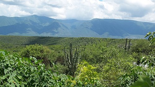
Two major mountain ranges extend north and south along Mexico’s coastlines and are actually extensions of southwestern US ranges. The Sierra Madre Occidental and the Sierra Madre Oriental are roughly parallel to each other. The Sierra Madre Occidental, an extension of the Sierra Nevada range, is about 3,107 miles along the west coast, with peaks higher than 9,843 feet. The Sierra Madre Oriental is an extension of the Rocky Mountains and is 808 miles along the east coast.
The Sierra Madre Occidental in Mexico
 The Sierra Oriental in Mexico
Between these two mountain ranges lies a group of broad plateaus, including the Mexican Plateau, or Mexican Altiplano (a wide valley between mountain ranges). The central portions, with their rolling hills and broad valleys include fertile farms and productive ranch land. The Mexican Altiplano is divided into northern and southern sections, with the northern section dominated by Mexico’s most expansive desert, the Chihuahuan Desert.
The Tulancingo Valley in Huasca de Ocampo, Hidalgo, Mexico, is located on the Mexican Altiplano
Another prominent mountain range is the Cordillera Neovolcánica range, which is a range of volcanoes nearly 620 miles east to west across the central and southern portion of the country. This range represents the dividing line between North and Central America. The peaks of the Cordillera Neovolcánica can reach higher than 16,404 feet in height and are snow covered the whole year.
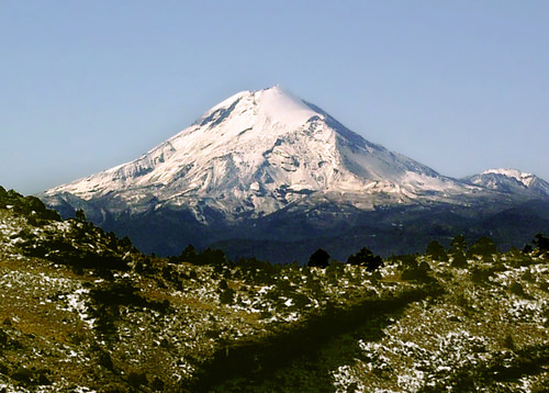
The Pico de Orizaba, the highest point in Mexico, is located in the Cordillera Neovolcánica range.
Copper Canyon, in the northern Mexican state of Chihuahua, is about seven times larger than the Grand Canyon. Copper Canyon was formed by six rivers flowing through a series of 20 different canyons. At its deepest point, Copper Canyon is 1,462 feet deeper than the Grand Canyon.
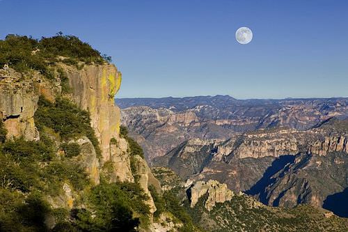 Divisadero, Barrancas del Cobre, Chihuahua, Mexico, is located in Copper Canyon.
More than one-quarter of Mexico’s landmass is covered in forests. As a result, timber is an important natural resource. Mexico's biodiversity ranks 4th in the world. It has the largest number of reptile species, ranks second for mammals, and ranks fourth for the number of amphibian and plant species. It is estimated that more than 10 percent of the world’s species live here. Deforestation is a key environmental concern, but timber remains an important natural resource. The loss of natural habitat coincides with depletion of natural resources and an increase in population.
Mexico is home to a range of volcanoes, some of which are active. Popocatépetl (Smoking Warrior) and Ixtaccíhuatl (White Lady) occasionally send out puffs of smoke clearly visible in Mexico City. Popocatépetl is one of the most active volcanoes in Mexico, erupting 15 times since the arrival of the Spanish in 1519 C.E. This volcano is close enough to populations to threaten millions of people.
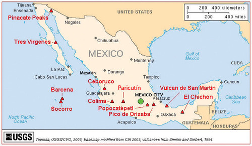
A map of the major volcanoes in Mexico.
Three tectonic plates underlie Mexico, making it one of the most seismically active regions on earth. In 1985, an earthquake centered off Mexico’s Pacific coast killed more than 10,000 people in Mexico City and did significant damage to the city’s infrastructure.
Many of Mexico’s natural resources lie beneath the surface. Mexico is rich in natural resources and has robust mining industries that tap large deposits of silver, copper, gold, lead, and zinc. Mexico also has a sizable supply of salt, fluorite, iron, manganese, sulfur, phosphate, tungsten, molybdenum, and gypsum. Natural gas and petroleum also make the list of Mexico’s natural resources and are important export products to the United States. There has been some concern about declining petroleum resources. However, new reserves are being found offshore in the Gulf of Mexico.
Though only about 13 percent of Mexico’s land area is cultivated, favorable climatic conditions mean that food products are also an important natural resource both for export and for feeding the country’s population. Tomatoes, corn, vanilla, avocado, beans, cotton, coffee, sugarcane, and fruit are harvested in large quantities. Of these, coffee, cotton, sugarcane, tomatoes, and fruit are primarily grown for export, with most of these products transported to the United States.
Mexico has pronounced wet and dry seasons. Most of the country receives rain between June and mid-October, with July being the wettest month. Much less rain occurs during the other months. February is usually the driest month. Mexico lies in the middle of the hurricane belt, and all of the regions on both coasts are at risk for these storms between June and November. Hurricanes along the Pacific coast are much less frequent and less violent than those along Mexico’s Gulf and Caribbean coasts. Hurricanes can cause extensive damage to infrastructure along the coasts where major tourist resorts are located. Mexico’s extensive and beautiful coastlines provide an important boon to the nation’s tourism industry.
The Core versus the Periphery
In the past few decades, the Mexican economy has slowly become less centralized and more focused on the private sector. The Mexican economy is a mix of modern industry, agriculture, and tourism. Current estimates indicate that the service sector makes up about 60 percent of the economy, followed by the industrial sector at 33 percent. Agriculture represents just above 4 percent. Per-capita income in Mexico is about one-third of what it is in the United States. The Mexican labor force is estimated at 46 million individuals. Fourteen percent of the labor force works in agriculture, 23 percent in the industrial sector, and 62 percent in the service sector.
Mexico is an example of a country with a clear core-periphery spatial relationship. Mexico City and its surrounding metropolitan centers represent the county’s core: the center of activity, industry, wealth, and power. Industries and manufacturing have been traditionally located in this region. As of 2010, the core region has most of the country’s 110 million people. Mexico’s population is about 77 percent urban, with the largest urban areas found in the core region.
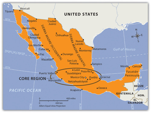
The periphery is the northern region, including the border area, and the southern region, including the Yucatán Peninsula.
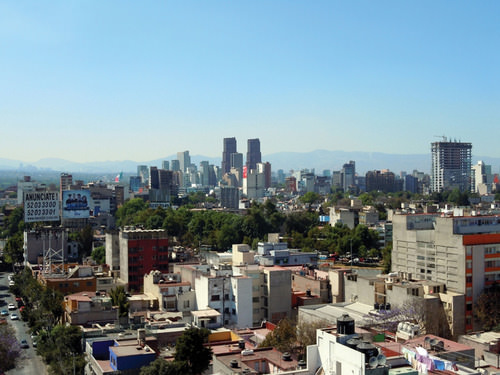
Mexico City is one of the largest cities in the world and anchors the core region of Mexico. In 2010, the official population of Mexico City was about 18 million, but unofficial population estimates can reach 30 million. The actual population of Mexico City is unknown because of the hundreds of slums that surround the city on the slopes of the central valley. Mexico City is growing at a rate of more than 1,000 people per day through a combination of the number of births and the number migrants.
The lure of opportunities and advantages still pulls migrants to the city in search of a better life. Higher populations tax the resources in rural areas, where jobs and opportunities are hard to find. This push-pull relationship creates a strong rural-to-urban shift in Mexico. This same trend is found throughout the developing world.
A day with extensive air pollution will restrict the view of the horizon.
Mexico City is a historic and vibrant city, but it is not without problems. At higher than 7,000 feet in elevation, it is located between two mountain ranges. Air pollution is severe and is made stronger by frequent air inversions that trap pollution over the city. To reduce air pollution, people are only allowed to drive their vehicles on certain days according to odd or even license plate numbers. Older vehicles that do not pass emissions standards are banned.
Fresh water is in short supply, and wastewater from sewage is discharged into lakes down the valley. Amerindians who live by these lakes or on the islands have to live with the pollution. Since four to five million inhabitants in Mexico City have no utilities, human waste buildup has become a challenge. Fresh water is pumped into the city through pipelines from across the mountains. Leakage and inadequate maintenance causes a large percentage of the water to be lost before it can be used in the city. Water is also drawn from underground aquifers beneath the city, which causes parts of the city to sink as much as two feet. Structural damage to historic buildings is common because of this.
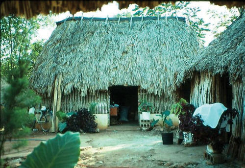
The Village of Yachachen in the Yucatán Peninsula is located in a peripheral region of Mexico.
One of Mexico’s largest peripheral regions lies to the south, along the country’s border with Guatemala. It includes the state of Chiapas and most of the Yucatán Peninsula. This area is primarily inhabited by Amerindians of Mayan ancestry. As is typical of peripheral regions, little political or economic power is held by the residents, who find themselves at the lowest end of the social and economic order.
The highland region of Chiapas and the Yucatán Peninsula are primarily agricultural regions with few industries. However, tourism has changed the northern Yucatán. Cancún has developed into a major tourist destination, and Mayan ruins in the region attract thousands of tourists each season. Unless the local population can benefit from tourism, there are few other opportunities for employment in this part of Mexico.
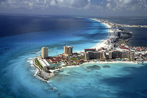
Cancún, Mexico attracts thousands of tourists every year.
Mexican Social Order
The early European control of the land, the economy, and the political system created conflict for the people of Mexico. The country has experienced domination followed by revolution at various times, starting with colonial domination, then economic domination, and lastly political domination. In each historic cycle, revolution and conflict were followed by change. The result was a mixing and acculturation of the Europeans and the Amerindians, which created the current mestizo mainstream society.
Mestizos make up about 60 percent of the current population, Europeans make up about 9 percent, and Amerindians make up about 30 percent. More than 60 indigenous languages spoken by Amerindian groups are recognized in Mexico. At least 17 indigenous languages are spoken by more than 100,000 people or more in Mexico, most of them living in the southern part of the country.
Mexican society is regionally and ethnically diverse, with sharp socioeconomic divisions. Many rural communities have strong ties with their regions and are often referred to as patrias chicas (“small homelands”), which helps to perpetuate the cultural diversity. The large number of indigenous languages and customs, especially in the southern parts of Mexico, further emphasize cultural diversity. Idigenismo (“pride in the indigenous heritage”) has been a unifying theme of Mexico since the 1930's.
Daily life in Mexico can be dramatically different according to socioeconomic class, gender, ethnicity, rural or urban settlements, and other cultural differences. A peasant farmer in the rainforests of the Yucatán will lead a very different life than a museum curator in Mexico City or a lower-middle-class auto factory worker in Monterrey.
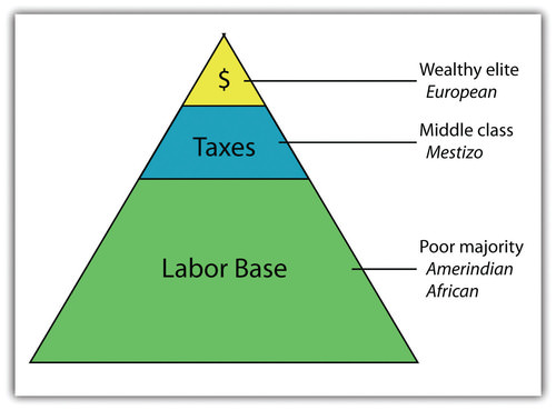
This graphic illustrates the socioeconomic classes in Mexico and most of Latin America.
Those of European descent are at the top of the pyramid and control a higher percentage of the wealth and power even though they are a minority of the population. The small middle class is largely mestizo, including managers, business people, and professionals. The working poor make up most of the population at the bottom of the pyramid. The lower class contains the highest percentage of people of Amerindian descent.
The most desirable type of social structure is illustrated by the diamond shape below. In the middle is a large, employed middle class that pays most of the taxes and purchases consumer goods that help bolster the economy. The narrow top is made up of the wealthiest, and the narrow bottom is made up of people who live in poverty. This type of social structure does not happen in Mexico, where about 40 percent of the population lives in poverty.
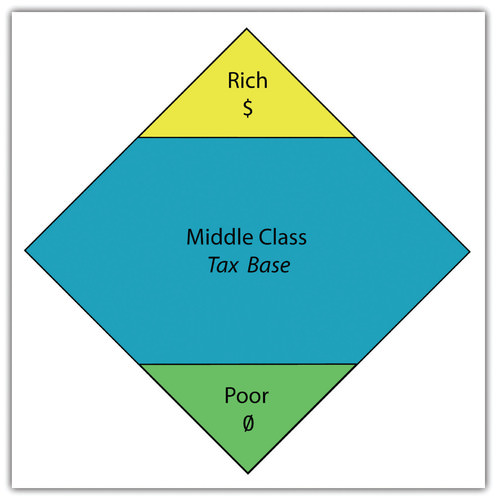
This graphic illustrates the ideal socioeconomic class structure with a large middle-class tax base.
Over the past century, the people of Mexico have been working through a demographic transition. As the rural regions of Mexico continued to have a high fertility rate, death rates declined, and the country’s population grew exponentially. In 1970, the population of Mexico was about 50 million. By the year 2000, it had more than doubled. However, the population estimate for 2017 was more than 124 million. As Mexico urbanizes and industrializes, family size and fertility rates have been in decline, and population growth has slowed.
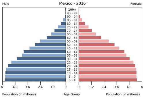
Age Structure of Mexico: 0-14 years: 26.93 percent (male 17,155,689/female 16,390,913); 15-24 years: 17.54 percent (male 11,065,927/female 10,778,382); 25-54 years: 40.81 percent (male 24,550,848/female 26,282,836); 55-64 years: 7.64 percent (male 4,362,868/female 5,160,514); 65 years and over: 7.09 percent (male 3,949,823/female 4,876,995)
The rural-to-urban shift has increased the population of Mexico City. Rural Amerindian groups in the isolated and remote mountainous regions of Mexico have historically been self-sufficient for their daily needs and have relied on the land for their livelihoods. In the past few decades, however, large family sizes have forced many young people to look to the cities for employment.
NAFTA and Maquiladoras
The North American Free Trade Agreement (NAFTA) is a 1994 economic agreement with Canada, the United States, and Mexico that eliminated or reduced the tariffs, taxes, and quotas in these countries. This agreement created the world’s largest trading bloc to compete with the European Union and the global economy. This theoretically allows more corporate investments across borders and increases foreign ownership of business facilities. It stimulated a shift in the location of industrial activity and in the migration patterns of people in Mexico.
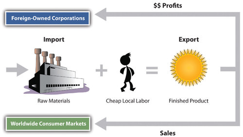
Capitalizing on the old industrial locations of northern Mexico, such as Monterrey, corporations started to relocate manufacturing plants from the United States to Mexico to benefit from the low-cost labor. Cheap labor inflated corporate profits and reduced product costs. The United States is one of the world’s largest consumer markets, so these manufacturing plants, called maquiladoras (also known as maquilas), benefited both countries.
Maquiladoras are foreign-owned factories that import most of the raw materials or components needed for the products they manufacture, assemble, or process with local cheap labor. The finished products are exported for profit. US corporations own more than half of the maquiladoras in Mexico, and about 80 percent of the finished goods are exported back to the United States. Although most maquiladoras are located near the US-Mexican border, additional factories are located around Monterrey and other cities with easy access to the United States. A major trade corridor is developing between Monterrey and Dallas/Ft. Worth, which acts as a gateway to the US markets.
Import/Export System of a Maquiladora Operation
Thousands of maquiladoras exist along the US-Mexican border, although the Mexican government has also promoted maquiladoras in other parts of Mexico. Maquiladoras provide jobs for workers in Mexico and provide inexpensive products for US consumers. There are some problems with this system, however.
Labor unions in the United States complain that the high-paying industrial jobs that support the US middle class are being lost to cheap Mexican labor. Labor laws in Mexico are less rigorous than laws in the United States. Maquiladora employees typically work longer hours and have less benefits than the average worker in the United States. Moreover, pollution standards in Mexico are not as restrictive as those in the United States, giving rise to environmental concerns.
The central US-Mexican border region has arid type B climates with fresh water in short supply. This is a problem because water is in high demand in industrial processes. With the rapid increase in employment along the border, many of the people who work in the factories do not have adequate housing or utilities. Extensive slum areas have grown around maquiladora zones, which have little law enforcement, high crime, and few services.
The US-Mexican border region has become a strong pull factor, attracting poor people who seek greater opportunities and advantages to move from Mexico City and other southern regions of Mexico to the border region to look for work. When they do not find work, they are compelled to cross the US border illegally. The United States is considered a land of opportunity and attracts immigrants—both legal and illegal—from Mexico. For political and economic reasons, the US political parties have not adequately addressed the problem of illegal immigrants from Mexico.
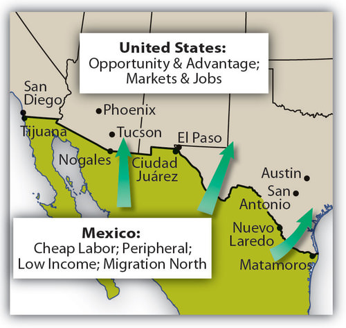
Opportunities and advantages drive the push-pull of migrants searching for improved economic conditions.
It is not only US corporations that have taken advantage of the explosion in the number of maquiladoras in Mexico. European and Japanese companies have also engaged in the market. Capitalism thrives on cheap labor and accessible raw materials. With much of this industrial activity located in the northern sector of Mexico, it becomes easier to understand the difficult issues that confront Mexico’s southernmost state of Chiapas, where there is little benefit from this growth of economic activity.
In 1995, Chile was considered a possible addition to the countries participating in NAFTA. However, US congressional differences have prevented Chile from being accepted as a full member. As a result, Chile remains a “silent partner” and conducts business according to similar rules. Agreements with Chile block Asian goods from making their way into the United States through Chile and Mexico. The United States, Mexico, and Canada all have full-fledged independent free-trade agreements with Chile.
The Free Trade Area of the Americas (FTAA) is a plan to integrate the entire Western Hemisphere into one giant trading bloc. The same concerns that the European Union faced regarding currency, language, and law confront this proposal. A new currency called the Eagle was proposed as early as the 1990s to replace the Canadian dollar, the US dollar, and the Mexican peso.
In later years, a currency called the Amero was proposed for the same purpose, but its implementation is unlikely. Any change in the US dollar would affect a great number of countries. Puerto Rico (a territory of the United States) and the countries of Ecuador, Panama, and El Salvador already use the US dollar as their standard currency. A one-currency solution might become a more viable option if the US dollar were to crash or significantly lose its value in the world marketplace.
A goal of NAFTA is to exploit cheap labor until the Mexican economy rises to a level similar to that of the United States and Canada, equalizing migration patterns and eventually bringing about a situation in which the border checkpoints between the countries could be eliminated, as they have been within the European Union. Through the development of a larger middle class in Mexico, NAFTA countries would have similar standards of living. Mexico has a long way to go to arrive at this status but is making progress.
Critics of NAFTA claim that the term free trade really means corporate trade. NAFTA is also viewed as a component of globalization in the form of corporate colonialism, which only benefits those wealthy enough to hold investments at the corporate level. The exploitation of cheap labor has increased immigration across the US-Mexican border, bringing millions of illegal workers into the United States. The Mexican government has not adequately addressed Mexico’s economic conditions to provide jobs and opportunities for the people or to use the wealth held or controlled by the elite minority to enhance economic opportunities for the middle- and lower-class majority.
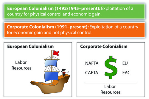
Slave labor was prominent during the European colonial era, whereas cheap labor is the target in neocolonial activity—that is, corporate colonialism.
Chiapas and NAFTA
The state of Chiapas in Mexico has an unequal distribution of wealth, a situation evident in most core-peripheral spatial relationships. Located in the rural highlands of Mexico and inhabited by a minority group that holds to the Mayan' language and traditions, Chiapas has few economic opportunities for its people. Wealthy landowners and the ruling elite who have long held power have routinely taken advantage of peasant farmers. The aristocracy uses the best land and pays low wages to local workers. Medical care, education, and government assistance have been slow in coming to this region and its people.
In the past few decades, various Amerindian groups have organized in the rural areas of Mexico in an attempt to counter the power of the political elite. In Chiapas, a group calling itself the Zapatista National Liberation Army (ZNLA) organized to coordinate an offensive against the Mexican government in various towns in the region. The ZNLA was organized to coincide with the implementation of NAFTA among the United States, Canada, and Mexico in January of 1994.
As each country claimed benefits from this agreement, the peripheral region of Chiapas sought to receive their share of those benefits. The Mexican military was quick to react to the ZNLA offensive and rapidly drove them out of the towns they had occupied. The publicity and the international press coverage assisted the ZNLA in getting their message out to the rest of the world.
Since 1994, the ZNLA’s guerrilla forces have used their familiarity with the mountains for sanctuary and have faced off against the Mexican military when negotiations with the federal government have broken down. The ZNLA want greater recognition of their rights and their heritage and more autonomy over their region and lands. This devolutionary process resembles that of various European regions desiring similar recognition of rights.
Similar conflicts are ongoing in other rural states of Mexico with the majority of Amerindian populations. There is a direct relationship between social status, wealth, and skin color in most regions of Mexico. The skin tone is directly related to a person’s social status. On the one hand, Aztec and Mayan heritage is celebrated. On the other hand, their identity and darker skin relegate them to a lower socioeconomic status.
Illegal Drug Trafficking in Mexico
The illegal drug trade is a multi-billion-dollar industry. Mexico has traditionally been the transitional area or stop-off point between the South American drug producing areas and entrance into US markets. Cocaine, marijuana, and heroin were produced in the Andes Mountains of South America and shipped north to the United States. Colombian cartels were once the main controllers of illegal drugs in the Western Hemisphere. However, in recent decades, organized crime units in Mexico have gained some control of drugs coming through Mexico. They make deals with their South American counterparts to become the main traffickers of drugs into the United States.
The influence and power of Mexican drug cartels have increased immensely since the demise of the Colombian cartels in the 1990s. Enormous profits fuel the competition for control. Just as the United States has declared a war on drugs and has used its Drug Enforcement Administration (DEA) as the main arm in combating the industry, Mexico has had to address its own issues in the illegal drug trade.
Illegal drug income flowing into Mexico has become a major part of the economy in specific areas. Drug kingpins have used their economic power to buy off local police forces and silence opposition. They have also been known to provide poor neighborhoods with funding for services that would normally be designated as government obligations. These actions have often provided a mixed reaction within the population in local areas. The drug cartels have become an integrated part of the fabric of Mexico.
In an attempt to combat the situation, the Mexican government has been engaged in its own internal war against the illegal drug trade. The battles between the drug cartels and the Mexican government have created a serious internal conflict in the country, killing thousands of innocent bystanders in the crossfire. Armed conflicts between rival cartels or local gangs have increased the violence that has been intensifying since the year 2000. Mexican cities near the US border have experienced increased incidences of major drug-related murders and gang violence. Higher volumes of firearms trafficking from the United States and abroad into Mexico have been fueling the armed conflicts. Military and police casualties have increased and the number of drug-related shootings is on the rise.
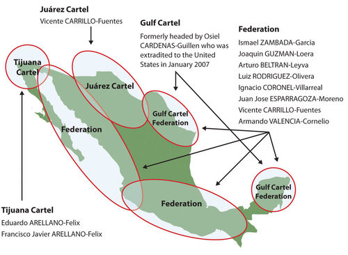
The drug cartels in Mexico have been a major influence on the economics and culture of the region.
Cartels have been known to use jet airliners, semi-trucks, and even submarines in their attempts to ship illegal drugs into the United States. Large tunnels have been found beneath the US-Mexican border that were used to smuggle drugs. Intimidation and corruption have been standard practices used by drug traffickers to protect their interests. Bribes and corruption have been difficult to battle in a country with a high percentage of the population living in poor conditions.
- Mexico possesses extensive natural resources that provide for a wide range of biodiversity and economic activities.
- Mexico portrays a clear core-periphery spatial relationship. Mexico City and its urban neighbors anchor the core, while the northern border region and states such as Chiapas represent the rural periphery.
- People of European heritage continue to hold positions of power and privilege in Mexico’s socioeconomic class structure. Amerindian populations exist at the lowest level with the fewest economic opportunities.
- Economic reforms that coincide with NAFTA have greatly enhanced the industrial capacity of Mexico and helped integrate the country into the global economy.
- Mexican drug traffickers have become the major controllers of illegal drugs entering the United States from the south. Drug cartels in Mexico reap enormous profits and have become a major problem for the Mexican government and the country.
Vocabulary Terms
| Aztecs | A Mesoamerican Native American Empire who lived in Mexico. Their capital was Tenochtitlan. They worshiped everything around them especially the sun. Cortes conquered them in 1521 |
| maquiladoras | Manufacturing plants/factories located in Mexico, usually along the US/Mexico border |
| Mayans | A Mesoamerican civilization of Central America and southern Mexico. Achievements include mathematics, architecture, and a 365 day a year calendar. They flourished between the 4th and 12th centuries C.E. |
| Mestizo | People of mixed Spanish and native decent |
| NAFTA-North American Free Trade Agreement. | A trade agreement between Canada, the United States and Mexico that encourages free trade between these North American countries |
| Tenochtitlan | Aztec capital built on an island in 1325, located where present-day Mexico City is located |
Applying Knowledge
Interactive Notebook Activities
- Describe the physical geography of Mexico, identifying the core and peripheral areas.
- List the socioeconomic classes in Mexico and explain the ethnic differences of each.
- Explain how the North American Free Trade Agreement (NAFTA) and maquiladoras have influenced the economic and employment situations in Mexico.
- Summarize in a few sentences how the drug cartels have become an integrated part of the Mexican economy and political situation.
Discussion and Study Questions
- What are the main physical features of Mexico?
- How does the core-periphery spatial relationship apply to Mexico?
- How can the socioeconomic pattern of Mexico be illustrated?
- How are maquiladoras structured to make them attractive to corporations?
- What are the current push-pull migration dynamics in Mexico?
- What change would bring about an open border between the United States and Mexico similar to that of the European Union?
- How are trade agreements and political unions reshaping our global community?
- How is NAFTA similar to the European Union and how is it different?
- How is Chiapas caught in the politics between the core and the periphery?
- How has the illegal drug trade affected Mexico?
Real-World Geography Exercise
Using Google Maps, locate the places listed below. Next, using NASA Latitude and Longitude Finder, determine the latitude and longitude for each location. Be prepared to share your answers.
- Baja California Peninsula
- Chiapas
- Chihuahuan Desert
- Cordillera Neovolcánica
- Mexican Altiplano
- Monterrey
- Sierra Madre Occidental
- Sierra Madre Oriental
- Yucatán Peninsula
Mapping Exercise
Migration, On the Move: Students will use ArcGIS Online to evaluate migration at the global, regional, and local scales. The activity uses a web-based map
Latin America Independence: Students will explore the factors leading to the independence movement of Latin American colonies.
Videos for Geography Enrichment
Helpful Websites for the Study of Geography
Canadian Encyclopedia is an encyclopedia funded by the Canadian government covering all branches of knowledge. Their scholarly collection includes interactive materials.
CIA World Factbook provides information on the people, history, government, economy, energy, geography, communications, transportation, military, and transnational issues for the world's entities.
Congress.gov is a US government website where you can find federal legislation, past and present, as well as information about the US legal system.
Drug Enforcement Administration (DEA) is a government agency website that provides current news, resources, topics of interest, information about drugs, careers in the DEA, and a tip hotline.
Library of Congress is the largest library in the world and provides manuscripts, files, information, pictures, and videos.
NASA Earth Observatory (NEO) is a US government agency website that allows users to search for and retrieve satellite images of Earth.
National Archives is a US government website that provides historical documents, photos, records, publications, and educator resources.
National Oceanic and Atmospheric Association (NOAA) is a US government agency website that provides weather-related information and ocean research.
National Map is a website by the United States Geological Survey and other federal, state, and local agencies that deliver topographic information for the United States.
NationMaster is a massive central data source and a handy way to graphically compare nations.
Real-Time World Air Quality Index is a website that measures most locations in the world for air pollution in real time.
StateMaster is a unique statistical database, which allows you to research and compare a multitude of different data on US states.
United Nations (UN) is an international organization founded in 1945 and made up of 193 member states. The UN maintains international peace and security, protects human rights, delivers humanitarian aid, promotes sustainable development, and upholds international law.
United States Census Bureau is a US government agency that provides a population clock, data, surveys, statistics, a library with information and infographics, news about the economy, and much more.
United States Geological Survey (USGS) is a US government agency website that provides scientific information about the natural hazards that threaten lives, the natural resources we rely on, the health of our ecosystems and environment, and the impacts of climate and land-use change.
Whitehouse.gov is a US government website that provides the latest presidential news, information about the budget, policy, defense, and many more topics.
World Health Organization (WHO) is under the United Nations and provides leadership on matters critical to health, shapes the research agenda on health, and monitors the health situation and assessing health trends around the world. Their website provides information on the state of health around the world, outbreaks, current health news, and more.
World Trade Organization (WTO) is an intergovernmental organization that regulates international trade. The website provides information on the history of the multilateral trading system, featured videos, news and events, trade topics, and more.
Explore the factors leading to the independence movement of Latin American colonies.
Mexico
| Image | Reference | Attributions |
|
[Figure 1] | Credit: By Jaime Sanchez Diaz (jsanchezd) (self-made, NIKON E5400, f/7.3, 1/354s) [GFDL (http://www.gnu.org/copyleft/fdl.html), CC-BY-SA-3.0 (http://creativecommons.org/licenses/by-sa/3.0/) or CC BY-SA 2.5 (https://creativecommons.org/licenses/by-sa/2.5)], via Wikimedia Commons Source: commons.wikimedia.org/wiki/File:Devils-Peak_Sierra-SanPedroMartir_BajaCalifornia_Mexico.jpg License: CC BY-NC 3.0 |
 |
[Figure 2] | Credit: By Christian Frausto Bernal [CC BY-SA 2.0 (https://creativecommons.org/licenses/by-sa/2.0)], via Wikimedia Commons Source: commons.wikimedia.org/wiki/File:Paisaje_de_la_Sierra_Madre_Occidental.jpg License: CC BY-NC 3.0 |
|
[Figure 4] | Credit: By Thelmadatter [CC BY-SA 3.0 (https://creativecommons.org/licenses/by-sa/3.0) or GFDL (http://www.gnu.org/copyleft/fdl.html)], from Wikimedia Commons Source: commons.wikimedia.org/wiki/File:TulancingoValleyHuasca3.JPG License: CC BY-NC 3.0 |
|
[Figure 5] | Credit: By _Pico_de_Orizaba_1.jpg: pacomexicoderivative work: Ricraider (talk)enhanced zoom (_Pico_de_Orizaba_1.jpg) [CC BY 2.0 (https://creativecommons.org/licenses/by/2.0)], via Wikimedia Commons Source: commons.wikimedia.org/wiki/File:Pico_de_Orizaba_1_Zoom.jpg License: CC BY-NC 3.0 |
|
[Figure 7] | Credit: Map courtesy of USGS/Cascades Volcano Observatory, http://vulcan.wr.usgs.gov/Volcanoes/...volcanoes.html. Source: open.lib.umn.edu/worldgeography/wp-content/uploads/sites/181/2016/04/733cd154f2c13c84054730d48ff16320.jpg License: CC BY-NC 3.0 |
|
[Figure 8] | Credit: open.lib.umn.edu/worldgeograp...er/5-2-mexico/ Source: open.lib.umn.edu/worldgeography/wp-content/uploads/sites/181/2016/04/5ed8fd089a832e23bca3f8143f4a3be8.jpg License: CC BY-NC 3.0 |
|
[Figure 9] | Credit: Matthew Rutledge – Wide view of Polanco – CC BY 2.0. Source: open.lib.umn.edu/worldgeography/wp-content/uploads/sites/181/2016/04/8ffffad8a722098c6c723efc9169fac3.jpg License: CC BY-NC 3.0 |
|
[Figure 10] | Credit: Photo by R. Berglee – CC BY-NC-SA. Source: open.lib.umn.edu/worldgeography/wp-content/uploads/sites/181/2016/04/452861250793444ec3c9bd8815ac30f7.jpg License: CC BY-NC 3.0 |
|
[Figure 11] | Credit: By Safa in la but uploaded by Mardetanha (http://www.safainla.us/) [GFDL (http://www.gnu.org/copyleft/fdl.html) or CC BY-SA 3.0 (https://creativecommons.org/licenses/by-sa/3.0)], via Wikimedia Commons Source: commons.wikimedia.org/wiki/File:Imagebysafa2.jpg License: CC BY-NC 3.0 |
|
[Figure 12] | Credit: open.lib.umn.edu/worldgeograp...er/5-2-mexico/ Source: open.lib.umn.edu/worldgeography/wp-content/uploads/sites/181/2016/04/5240cda9414e6f6aebef16924a56409a.jpg License: CC BY-NC 3.0 |
|
[Figure 13] | Credit: http://open.lib.umn.edu/worldgeograp...er/5-2-mexico/ Source: open.lib.umn.edu/worldgeography/wp-content/uploads/sites/181/2016/04/9129ecd539c68558308da79550b29d44.jpg License: CC BY-NC 3.0 |
|
[Figure 14] | Credit: cia world factbook Source: https://www.cia.gov/library/publications/the-world-factbook/geos/mx.html License: CC BY-NC 3.0 |
|
[Figure 15] | Credit: http://open.lib.umn.edu/worldgeograp...er/5-2-mexico/ Source: open.lib.umn.edu/worldgeography/wp-content/uploads/sites/181/2016/04/a47e468b48157c3c29c38347a0ce761a.jpg License: CC BY-NC 3.0 |
|
[Figure 16] | Credit: http://open.lib.umn.edu/worldgeograp...er/5-2-mexico/ Source: open.lib.umn.edu/worldgeography/wp-content/uploads/sites/181/2016/04/c4230ec463a0ab44e457f6821d3d15ee.jpg License: CC BY-NC 3.0 |
|
[Figure 17] | Credit: http://open.lib.umn.edu/worldgeograp...er/5-2-mexico/ Source: open.lib.umn.edu/worldgeography/wp-content/uploads/sites/181/2016/04/1d2ca5046450e1e2babb91ca75e25231.jpg License: CC BY-NC 3.0 |
|
[Figure 18] | Credit: Map courtesy of US Congress, Committee on Foreign Relations. Source: open.lib.umn.edu/worldgeography/wp-content/uploads/sites/181/2016/04/7557da9c8da5090c5f4bbbf5c2e4ef8e.jpg License: CC BY-NC 3.0 |