
5.5: Eastern Europe (2 Days)
- Page ID
- 1887
\( \newcommand{\vecs}[1]{\overset { \scriptstyle \rightharpoonup} {\mathbf{#1}} } \)
\( \newcommand{\vecd}[1]{\overset{-\!-\!\rightharpoonup}{\vphantom{a}\smash {#1}}} \)
\( \newcommand{\dsum}{\displaystyle\sum\limits} \)
\( \newcommand{\dint}{\displaystyle\int\limits} \)
\( \newcommand{\dlim}{\displaystyle\lim\limits} \)
\( \newcommand{\id}{\mathrm{id}}\) \( \newcommand{\Span}{\mathrm{span}}\)
( \newcommand{\kernel}{\mathrm{null}\,}\) \( \newcommand{\range}{\mathrm{range}\,}\)
\( \newcommand{\RealPart}{\mathrm{Re}}\) \( \newcommand{\ImaginaryPart}{\mathrm{Im}}\)
\( \newcommand{\Argument}{\mathrm{Arg}}\) \( \newcommand{\norm}[1]{\| #1 \|}\)
\( \newcommand{\inner}[2]{\langle #1, #2 \rangle}\)
\( \newcommand{\Span}{\mathrm{span}}\)
\( \newcommand{\id}{\mathrm{id}}\)
\( \newcommand{\Span}{\mathrm{span}}\)
\( \newcommand{\kernel}{\mathrm{null}\,}\)
\( \newcommand{\range}{\mathrm{range}\,}\)
\( \newcommand{\RealPart}{\mathrm{Re}}\)
\( \newcommand{\ImaginaryPart}{\mathrm{Im}}\)
\( \newcommand{\Argument}{\mathrm{Arg}}\)
\( \newcommand{\norm}[1]{\| #1 \|}\)
\( \newcommand{\inner}[2]{\langle #1, #2 \rangle}\)
\( \newcommand{\Span}{\mathrm{span}}\) \( \newcommand{\AA}{\unicode[.8,0]{x212B}}\)
\( \newcommand{\vectorA}[1]{\vec{#1}} % arrow\)
\( \newcommand{\vectorAt}[1]{\vec{\text{#1}}} % arrow\)
\( \newcommand{\vectorB}[1]{\overset { \scriptstyle \rightharpoonup} {\mathbf{#1}} } \)
\( \newcommand{\vectorC}[1]{\textbf{#1}} \)
\( \newcommand{\vectorD}[1]{\overrightarrow{#1}} \)
\( \newcommand{\vectorDt}[1]{\overrightarrow{\text{#1}}} \)
\( \newcommand{\vectE}[1]{\overset{-\!-\!\rightharpoonup}{\vphantom{a}\smash{\mathbf {#1}}}} \)
\( \newcommand{\vecs}[1]{\overset { \scriptstyle \rightharpoonup} {\mathbf{#1}} } \)
\(\newcommand{\longvect}{\overrightarrow}\)
\( \newcommand{\vecd}[1]{\overset{-\!-\!\rightharpoonup}{\vphantom{a}\smash {#1}}} \)
\(\newcommand{\avec}{\mathbf a}\) \(\newcommand{\bvec}{\mathbf b}\) \(\newcommand{\cvec}{\mathbf c}\) \(\newcommand{\dvec}{\mathbf d}\) \(\newcommand{\dtil}{\widetilde{\mathbf d}}\) \(\newcommand{\evec}{\mathbf e}\) \(\newcommand{\fvec}{\mathbf f}\) \(\newcommand{\nvec}{\mathbf n}\) \(\newcommand{\pvec}{\mathbf p}\) \(\newcommand{\qvec}{\mathbf q}\) \(\newcommand{\svec}{\mathbf s}\) \(\newcommand{\tvec}{\mathbf t}\) \(\newcommand{\uvec}{\mathbf u}\) \(\newcommand{\vvec}{\mathbf v}\) \(\newcommand{\wvec}{\mathbf w}\) \(\newcommand{\xvec}{\mathbf x}\) \(\newcommand{\yvec}{\mathbf y}\) \(\newcommand{\zvec}{\mathbf z}\) \(\newcommand{\rvec}{\mathbf r}\) \(\newcommand{\mvec}{\mathbf m}\) \(\newcommand{\zerovec}{\mathbf 0}\) \(\newcommand{\onevec}{\mathbf 1}\) \(\newcommand{\real}{\mathbb R}\) \(\newcommand{\twovec}[2]{\left[\begin{array}{r}#1 \\ #2 \end{array}\right]}\) \(\newcommand{\ctwovec}[2]{\left[\begin{array}{c}#1 \\ #2 \end{array}\right]}\) \(\newcommand{\threevec}[3]{\left[\begin{array}{r}#1 \\ #2 \\ #3 \end{array}\right]}\) \(\newcommand{\cthreevec}[3]{\left[\begin{array}{c}#1 \\ #2 \\ #3 \end{array}\right]}\) \(\newcommand{\fourvec}[4]{\left[\begin{array}{r}#1 \\ #2 \\ #3 \\ #4 \end{array}\right]}\) \(\newcommand{\cfourvec}[4]{\left[\begin{array}{c}#1 \\ #2 \\ #3 \\ #4 \end{array}\right]}\) \(\newcommand{\fivevec}[5]{\left[\begin{array}{r}#1 \\ #2 \\ #3 \\ #4 \\ #5 \\ \end{array}\right]}\) \(\newcommand{\cfivevec}[5]{\left[\begin{array}{c}#1 \\ #2 \\ #3 \\ #4 \\ #5 \\ \end{array}\right]}\) \(\newcommand{\mattwo}[4]{\left[\begin{array}{rr}#1 \amp #2 \\ #3 \amp #4 \\ \end{array}\right]}\) \(\newcommand{\laspan}[1]{\text{Span}\{#1\}}\) \(\newcommand{\bcal}{\cal B}\) \(\newcommand{\ccal}{\cal C}\) \(\newcommand{\scal}{\cal S}\) \(\newcommand{\wcal}{\cal W}\) \(\newcommand{\ecal}{\cal E}\) \(\newcommand{\coords}[2]{\left\{#1\right\}_{#2}}\) \(\newcommand{\gray}[1]{\color{gray}{#1}}\) \(\newcommand{\lgray}[1]{\color{lightgray}{#1}}\) \(\newcommand{\rank}{\operatorname{rank}}\) \(\newcommand{\row}{\text{Row}}\) \(\newcommand{\col}{\text{Col}}\) \(\renewcommand{\row}{\text{Row}}\) \(\newcommand{\nul}{\text{Nul}}\) \(\newcommand{\var}{\text{Var}}\) \(\newcommand{\corr}{\text{corr}}\) \(\newcommand{\len}[1]{\left|#1\right|}\) \(\newcommand{\bbar}{\overline{\bvec}}\) \(\newcommand{\bhat}{\widehat{\bvec}}\) \(\newcommand{\bperp}{\bvec^\perp}\) \(\newcommand{\xhat}{\widehat{\xvec}}\) \(\newcommand{\vhat}{\widehat{\vvec}}\) \(\newcommand{\uhat}{\widehat{\uvec}}\) \(\newcommand{\what}{\widehat{\wvec}}\) \(\newcommand{\Sighat}{\widehat{\Sigma}}\) \(\newcommand{\lt}{<}\) \(\newcommand{\gt}{>}\) \(\newcommand{\amp}{&}\) \(\definecolor{fillinmathshade}{gray}{0.9}\)- Explain how Eastern Europe and Western Europe were divided and how they united again.
- Describe the various aspects of the transition from socialism systems to capitalist democracies.
- Outline which countries were former republics of the Soviet Union but are now a part of Eastern Europe. Define the current borders of Eastern European countries.
- Describe some of the cultural dynamics that make each region or country unique.
- Summarize the basic economic activities that are evident in the various countries and how they have transitioned into a postindustrial economy.
- Understand the cultural and political geography of former Yugoslavia and how the drive for nationalism and nation-state status has fractured and divided the region.
TEKS Regional World Geography Unit 05 Europe: Chapter 5.5 Eastern Europe
WG.2A Describe the human and physical characteristics of the same regions at different periods of time to evaluate relationships between past events and current conditions.
WG.5A Analyze how the character of a place is related to its political, economic, social, and cultural elements.
WG.5B Interpret political, economic, social, and demographic indicators (gross domestic product per capita, life expectancy, literacy, and infant mortality) to determine the level of development and standard of living in nations using the terms Human Development Index, less developed, newly industrialized, and more developed.
WG.6B Explain the processes that have caused changes in settlement patterns, including urbanization, transportation, access to and availability of resources, and economic activities.
WG.7B Explain how political, economic, social, and environmental push and pull factors and physical geography affect the routes and flows of human migration.
WG.9A Identify physical and/or human factors such as climate, vegetation, language, trade networks, political units, river systems, and religion that constitute a region.
WG.10A Describe the forces that determine the distribution of goods and services in free enterprise, socialist, and communist economic systems.
WG.10C Classify where specific countries fall along the economic spectrum between free enterprise and communism.
WG.12A Analyze how the creation, distribution, and management of key natural resources affects the location and patterns of movement of products, money, and people.
WG.18B Assess causes, effects, and perceptions of conflicts between groups of people, including modern genocides and terrorism.
WG.18D Evaluate the spread of cultural traits to find examples of cultural convergence and divergence such as the spread of democratic ideas, US-based fast-food franchises, the English language, technology, or global sports.
WG.22B Generate summaries, generalizations, and thesis statements supported by evidence.
WG.22C Use geographic terminology correctly.
WG.22D Use standard grammar, spelling, sentence structure, and punctuation.
TEKS and ELPS for Regional World Geography Unit 5--Europe from TEKS Resource System
Eastern Europe
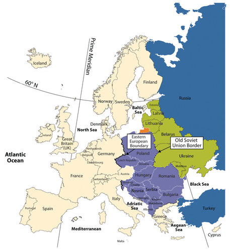 Map of Eastern Europe
Transitions of Eastern Europe after the Cold War
After World War II ended in 1945, Europe was divided into Western Europe and Eastern Europe by the Iron Curtain. Eastern Europe fell under the influence of the Soviet Union, and the region was separated from the West. When the Soviet Union collapsed in 1991, all the Soviet Republics bordering Eastern Europe declared independence from Russia and united with the rest of Europe. Most of the countries are now looking to Western Europe for trade and economic development. Cooperation continues between Eastern and Western Europe, and the European Union (EU) has emerged as the primary economic and political entity of Europe.
The collapse of Communism and the Soviet Union led to upheaval and transition in the region of Eastern Europe in the 1990s. Each country in the region was under Communist rule. The countries bordering Russia were once part of the Soviet Union, and those countries not part of the Soviet Union were heavily influenced by its dominant position in the region. When the Soviet Union collapsed in 1991, the bordering countries declared independence and began the process of integration into the European community.
Moldavia changed its name to Moldova. The countries of Czechoslovakia and Yugoslavia each broke into multiple countries. Because of the diverse ethnic populations, these countries organized around the concept of nation-states. Czechoslovakia peacefully agreed to separate into two states: the Czech Republic and the Republic of Slovakia. Yugoslavia was not so fortunate.
Most Eastern European political borders resemble ethnic boundaries. Each of the regions once resembled nation-states. In principle, Romania is set apart for Romanians, Hungary for Hungarians, and so on. Few are true nation-states because of ethnic minorities located within their borders, but the countries held on to their common heritage throughout the Communist era. In most Eastern European countries, cultural forces have brought people together to publicly support the move to unite and hold onto a heritage that is as old as Europe itself.
Governments that had been controlled by Communist dictators or authoritarian leaderships before 1991 were opened up to democratic processes with public elections. With the fall of Communism came economic reforms that shifted countries from central planning to open markets. Under central planning, the governments dictated which products were produced and how many of each were to be produced. The open markets invited private capitalism and western corporate businesses.
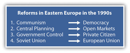 This graphic illustrates the reforms in eastern Europe in the 1990's.
The power of the state was transferred from the Communist elite to the private citizen. People could vote for their public officials and could choose businesses and work individually. With the EU looming over the realm, the now-independent countries of Eastern Europe shifted their economic direction away from Moscow and the collapsing Communist state and toward the core industrial countries of Western Europe and the EU.
The stage for the transition from communism to capitalism was further set by Soviet leader Mikhail Gorbachev, who began to liberalize the Soviet Union by allowing multiparty elections and encouraging economic reform and societal openness. At the same time, the world watched as the Chinese government violently cracked down on student protests in the Tiananmen Square protests of 1989, which strengthened the revolutionary sentiments and intentions of many people in the Eastern bloc, the former Communist countries of Eastern Europe.
Countries of Eastern Europe
Hungary
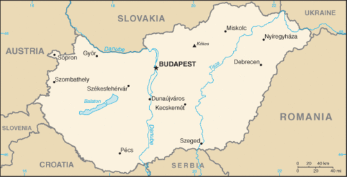 Map of Hungary
During the Communist period, Hungary enjoyed a higher standard of living than its neighbors. It was likely the marked contrast in daily life between the Communist period and the post-Communist period that influenced the outcome of the 1994 elections. These elections gave the Hungarian Socialist Party, led by former Communists, an absolute majority in Parliament. Many were concerned that Hungary was signaling a wish to return to the past. Instead, all three main political parties joined together to work toward the common goals of continued liberalization of the economy, closer ties with the West, and full EU membership.
Economic reforms have not been easy for Hungary and have resulted in a lower standard of living for most people. The removal of government subsidies after Communism led to a recession. To avoid inflation and attract investment, government fiscal policies had to be conservative. Hungary's large-scale manufacturing and stable government have aided it through the latest global economic downturn.
An important characteristic of post-Communist Hungary is its desire to become an active member of the global community by joining international organizations. In 1990, Hungary was the first Eastern Bloc nation to join the Council of Europe. In 2004, Hungary joined the EU. In addition, Hungary joined the other international organizations, including the Organization for Economic Co-operation and Development (OECD), the International Monetary Fund (IMF), and the World Trade Organization (WTO).
Another endeavor that would not have been possible under the Communist rule was the development of tourism. Budapest’s reputation as a city of great elegance has helped it become one of the major tourist attractions in Eastern Europe. Major movie studios have also traveled to the city to film.
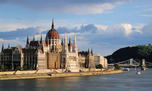 Parliament Building in Budapest, Hungary, next to the Danube River.
The Czech Republic and the Slovak Republic (Slovakia)
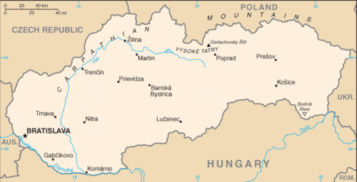 Map of Slovakia
Each country in Eastern Europe has a different story to tell about the path from communism to independence. Countries such as the Czech Republic and Hungary were more prepared and better equipped to meet the challenges. Historically, the region occupied by the modern Czech Republic was known as Bohemia and Moravia. The Czech Republic and Slovakia were, until recently, part of the same country of Czechoslovakia. On January 1, 1993, they became two newly independent nations. Slovakia is known officially as the Slovak Republic.
Czechs and Slovaks alike descended from Slavic peoples. The national language of the Czech Republic is Czech, while the official language of Slovakia is Slovakian. Both languages are in the Slavic linguistic family. About 94 percent of the population of the Czech Republic identify themselves as ethnically Czech. The others are Slovenian, Polish, German, Hungarian, and Roma. About 86 percent of the inhabitants of Slovakia identify as ethnically Slovakian. Hungarians make up the largest minority population, and about two percent of the population identify themselves as Roma.
Under Communist rule, the standard of living was very high in Czechoslovakia. When market reforms began in the Czech Republic and Slovakia, the standard of living declined to some extent. In general, the Czech Republic has more rapidly and effectively transferred state control of industry to private ownership than has Slovakia. Also, Slovakia was hit harder by the move away from defense industries, which had employed many people during the Communist period. Unemployment has consistently been higher in Slovakia. Slovakia is not as industrialized as the Czech Republic but has made strides since independence to provide economic opportunities for its people. Both countries expanded their economic opportunities when they were admitted into the EU in 2004.
The Baltic Republics
The small Baltic states of Latvia, Estonia, and Lithuania transitioned away from their old Soviet connections. After independence, they were quick to look toward Western Europe for trade and development. Most Eastern European countries followed this pattern. Latvia, Estonia, and Lithuania received their independence from the Soviet Union in 1991. Russia withdrew its troops from the region in 1994. The North Atlantic Treaty Organization (NATO) and the EU welcomed them as members in 2004. They have transitioned to market economies with democratic governments. The people of Latvia, Estonia, and Lithuania rapidly expanded their economic conditions after independence but have been hard hit by the downturn in the global marketplace in 2008.
Poland has a long-standing history of working to oppose the Communist domination of its country. The Solidarity movement in Poland started out as an independent trade union in the 1980s but then gained momentum for political change in Poland. The Communist Party dominated politics and suppressed any movement to organize labor or the people against the government. The strength of Solidarity became evident by the 1990 election when Solidarity candidate Lech Wałęsa won Poland’s presidential election. Solidarity’s victory signified the collapse of the power of the Soviet Union and Communism in Eastern Europe. The country has emerged with a democratic government and a thriving capitalist economy.
Since the fall of Communism, Poland left behind its old state-directed economy and transitioned to a market economy. When the Communists controlled Poland, there was an emphasis on heavy industry, and that focus remains alive today. Poland produces cars, buses, helicopters, trains, and heavy military equipment, including tanks and ships. Before the Communists industrialized the Polish economy, it was largely agrarian.
Though Poland continues to be one of Europe’s leading agricultural producers, with a wide variety of crops and dairy and meat production, it is unable to meet the food demands of its large population. Poland’s economy is still considered to be under development. Reforms, including privatization, must continue before Poland can adopt the euro, the common EU currency.
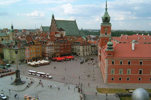 Royal Castle Square in Warsaw, Poland.
Unemployment has at times presented big problems for the Polish economy and society. Unemployment rose to nearly 20 percent in the early 1990s. The situation improved, but unemployment was still at about 14 percent in 2006. By 2010 the situation improved further, and the unemployment rate was around 7 percent. In 2018, the unemployment rate has gone down to 4.4 percent. When Poland joined the EU, many people left Poland in search of work. Some of those workers who left have recently returned, as the employment rate and wages are both increasing.
Moldova
A variety of cultural and social forces provided different levels of civility in the transitions of Eastern Europe. The poor, agrarian economy of the small, landlocked country of Moldova provides few opportunities or advantages to grow its economy and provide a stronger future for its people. As a result, young people earning an education or technical skills immigrate to other countries for opportunities or employment.
Belarus
In 1991, independence came to the former Soviet Republic of Belarus, but Belarus took a different path from most of the other Eastern bloc countries. Belarus did not distance itself from its Russian connection. Belarus has consequently experienced authoritarian governments well into the 21st century. In this case, Russia and Belarus created a stronger relationship by signing agreements to increase economic integration.
Difficulties have hindered implementation of many of these policies. For one thing, the government of Belarus has been slow to move toward democratic reforms. In fact, the president has taken on greater authoritarian powers. Some of the personal freedoms that have been granted in other European countries such as freedom of the press, free speech, and the right to peacefully assemble are restricted in Belarus. As of 2018, Belarus, Ukraine, and Moldova have not been admitted into the EU. Belarus has indicated that it might join with the Russian Republic and has not even applied for entry into the EU.
Ukraine
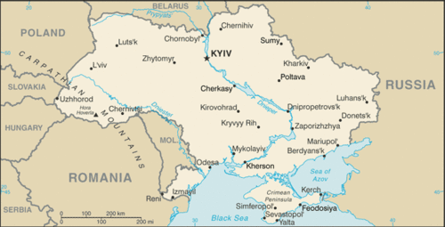 Map of Ukraine
With the largest physical area in Europe, Ukraine is slightly larger than France. Its population in 2018 was approximately 44 million, most of whom live in the industrial regions of the southeast or eastern parts of the country. Though the official language is Ukrainian, many Ukrainians still speak Russian. As is the case with neighboring states, the Eastern Orthodox Church dominates the religious and cultural reflections of the arts, literature, and architecture. Christian themes are often reflected in the paintings, books, and performances.
The demographic trend in Ukraine follows a pattern of industrialization with smaller family sizes. They have a higher death rate than most European countries. The country is now losing about 150,000 people per year. The low birth rates are similar to those of Russia and southern Europe. Poor health and childhood poverty in Ukraine are two of the main issues confirmed by the United Nations (UN).
In 2010, Ukraine had a negative population growth rate of −0.62 percent. Fertility rates have been in decline throughout Europe over the past few decades. The average fertility rate in Ukraine is 1.1, one of the world’s lowest. In Europe as a whole, the average is about 1.3. The causes for some of these trends can be attributed to alcoholism, poor diets, smoking, and the lack of medical care. The average life expectancy for an adult male in Ukraine is about 62 years. In comparison, the average life expectancy for men in France is about 78 years.
Of the former Soviet Union republics, excluding Russia, Ukraine was the most important economic piece, producing about four times the output of the next-ranking Soviet republic. Its fertile black soil generated more than one-fourth of the overall Soviet agricultural output, and its farms provided substantial quantities of meat, milk, grain, and vegetables to other republics. Likewise, its diversified heavy industry supplied steel pipes and raw materials to Russia’s oil and mining industry.
Ukraine’s political relationship with Russia has been complicated since the breakup of the Soviet Union, but Russia still supplies enormous amounts of natural gas and oil for the economy. Russia’s markets are still highly integrated with those of Ukraine.
Though Ukraine has transitioned from a Soviet republic to a fully independent country, divisive centrifugal forces have made Ukraine’s path to free elections and democratically elected leaders difficult. The country has held political elections, but they have been challenged or tainted with corruption and accusations of fraud. Today, the country has a democratically elected government and is working toward improving its economy and creating stability for its people.
Romania
 Map of Romania
Many countries of Eastern Europe have fully transitioned from Communist dictatorships to modern, integrated economies. Romania is one of those countries. Romania encompasses an area equivalent to the US state of Minnesota. Its approximate population of 21.5 million people includes two million who live in Bucharest, the capital and largest city of the country.
The Carpathian Mountains circle Romania, with the Transylvanian Alps to the south. The Danube River runs across the region and creates a natural border with Bulgaria and Serbia before flowing into the Black Sea. The Romanian forests are some of the largest in Europe, with about one-half (13 percent of the country) set aside from logging and placed in watershed conservation programs. The ecosystems in the Romanian forests provide diverse habitats for plants and animals. Romania claims to have the most European brown bears and about 40 percent of all European wolves living within its borders.
Tourism is growing in Romania. Almost five percent of Romania is placed in protected areas, including 13 national parks and three biosphere reserves, all of which are attractive to tourists. Tourist attractions also include medieval castles and historic Transylvanian cities. Rural tourism focuses on folklore and traditions including such sites as Bran Castle, referred to locally as the castle of Dracula, a mythical person patterned after the stories and legends of Vlad III the Impaler.
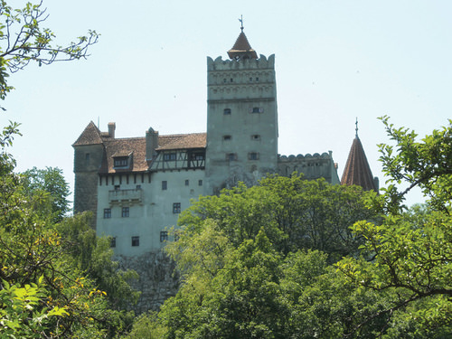 Bran Castle near Brasov in Transylvania.
Romania’s Communist dictator, Nicolae Ceauşescu, ruled from 1965 to 1989. The end of his regime came when the government was overthrown by a revolution. Ceauşescu and his wife were arrested and executed. Even after his death, the Communist Party maintained strong ties to the government until the mid-1990s.
The transition to integrate Romania’s economy with that of the greater European economy was delayed because of Romania’s outdated industrial infrastructure, established during the Communist era. Since joining the EU in 2007, Romania has developed a stronger export market with Western European countries. Investments and consumer confidence have fueled the growth of the domestic economy. Romania has worked through a number of difficult issues in its attempt to provide a stable government and a growing market economy.
Albania
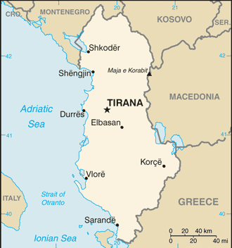 Map of Albania
The southern Adriatic is home to the small country of Albania. The rugged mountainous country of Albania has a Muslim majority. Poverty, unemployment, and a lack of opportunities to gain wealth have plagued the country. Albania has even received Communist support from China. As a result of the war in Kosovo, Albania suffered a major setback in its progress toward an improved standard of living and integration with the rest of Europe.
When stability is established, Albania can progress toward becoming more integrated with the European economy and raise its standard of living for its people. Parliamentary democracy has been installed since the Communist era, and foreign investments have aided in developing updated transportation and power grids.
Bulgaria
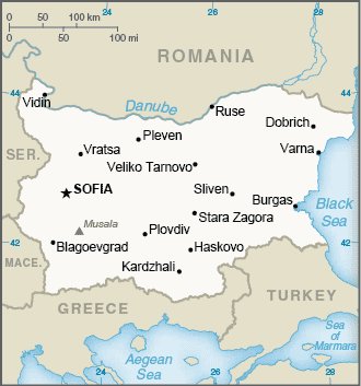 Map of Bulgaria
Located in the crossroads of the continents, Bulgaria has a major trans-European corridor running through its territory that connects all the way to Asia. The country is home to diverse landscapes. These landscapes include the Black Sea coast and the higher elevations of the Balkan Mountains, which reach an elevation of 9,596 feet. The Danube River flows across the border with Bulgaria on its way to the Black Sea. About one-third of the country consists of plains, which provide for extensive agricultural activity. Ore and minerals can also be found in Albania, which has allowed the country to gain wealth.
Upon declaring independence from Russia, Bulgaria held multiparty elections. Its economy is emerging, but the transition to a capitalist system has had difficulties with unemployment, inflation, and corruption. Bulgaria became a member of NATO in 2004 and was accepted for EU membership in 2007. The transition to a free market economy is still in progress, with mining, industry, and agriculture as the main economic activities.
Tourism is an emerging segment of the economy that has been gaining international attention in recent years. The country has a milder climate than the northern states of Eastern Europe and has been marketing itself as a major tourist destination. Main points of interest include historical monasteries, coastal resorts on the Black Sea, and the capital city of Sofia.
Here is an example of cultural differences between the United States and Bulgaria. This story is from Elizabeth Kelly, a US Peace Corps volunteer working in Bulgaria (2003–5).
“I’ll have coffee,” I tell the waitress at a cafe during my first week in Bulgaria. She shakes her head from side to side. “OK, tea,” I say, thinking that maybe there’s something wrong with the coffee machine. Again, she shakes her head. “Um. cola?” Once more, she shakes her head. By now, she’s looking at me like I’m crazy, and I’m totally confused. Then I remember: A shake of the head by a Bulgarian means “yes,” and a nod—what the rest of the world does for “yes”—means “no.”
Early on, when I communicated with Bulgarians, it seemed like my head was moving in ways my brain hadn’t told it to. Sometimes I wanted to grab my ears and use them as controls. Learning a language with a completely different alphabet was challenging enough without trying to figure out whether to nod or shake.
When I began teaching, all this head bobbing made communication in the classroom interesting. Although I had made sure my students knew about this cultural difference on the first day of school, we all frequently forgot what we were doing. My students would answer a question correctly or say something really great, and I’d nod. A second later, they were trying to change their answer, since they thought the nod meant they had been wrong. But the confusion went both ways. Sometimes I’d ask a student a yes-or-no question and he or she would answer with a nod or a shake, without saying anything. Not remembering the difference, we’d have to go through the motions several times before I understood. Frequently I found myself saying, “Da or ne—just tell me one or the other!”
I also had to deal with confused colleagues who couldn’t figure out why I kept nodding my head while they talked as if I were arguing with them. In truth, I was just trying to show that I understood and was following along with the story. And then there was the even greater problem of how to act with Bulgarians who spoke English and were aware of the nodding–shaking problem. Was I supposed to nod or shake for “yes” when I was speaking English with them? And what was I supposed to do when we were speaking Bulgarian? What if we were in a situation where both languages were being spoken? To make matters even more complicated, after going a couple of weeks without any contact with other Americans, we’d finally get together and I’d find myself shaking when I should have been nodding. My head was spinning!
Tuning in to how the people around me communicate has brought me closer to the people and the culture of Bulgaria. And whenever we slip up and forget to control our heads, the laughter that follows brings us together. Luckily, a smile is a smile the world over.
Source: Peace Corps Coverdell World Wise Schools program. Used by permission.
Former Yugoslavia
A Valuable Lesson in Political and Cultural Geography
The name Yugoslavia, applied to the region along the Adriatic in 1929, means Land of the South Slavs. From 1918 to 1929, the region had been called the Kingdom of Serbs, Croats, and Slovenes. Non-Slavic populations surround Yugoslavia. The region’s core is mountainous. The Dinaric Alps, with the highest peak at just below nine thousand feet in elevation, run through the center of the Balkan Peninsula.
The rugged mountains separate and isolate groups of Slavic people who, over time, have formed separate identities and consider themselves different from those on the other sides of the mountain ridges. Distinct sub-ethnic divisions developed into the Slovenes, Macedonians, Bosnians, Montenegrins, Croats, and Serbs, with various additional groups. These differences led to conflict, division, and war when the breakup of former Yugoslavia began.
World War I started in the city of Sarajevo, Bosnia, when a Serb advocate assassinated Archduke Ferdinand of the Austria-Hungarian Empire. In the next conflict, World War II, there was also divisiveness within Yugoslavia. Croatia sided with Nazi Germany, but Serbia was an ally with the Communist Soviet Union. The region of Bosnia, with a Muslim majority, faced religious opposition from its mainly Christian neighbors. A group headed by Marshal Tito led Yugoslavia after World War II ended in 1945. Tito created a Communist state that attempted to retain its own brand of neutrality between the Warsaw Pact nations led by the Soviet Union and the NATO nations of the West.
Tito was a centripetal force for the region of Yugoslavia. For over 40 years, he held the many ethnic Slavic groups together under what he called Brotherhood and Unity, which was actually the threat of brute military force. The 1984 Winter Olympics were held in Sarajevo as a witness to the progress and unity of Tito’s Yugoslavia. At the same time, Yugoslavia started manufacturing a model of automobiles called the Yugo. While the Yugo was not in the same league as high-end European luxury cars, the ability to make and purchase automobiles was a testimony to the rising industrial level of the Yugoslav economy. This progressive trend, unfortunately, was not to last.
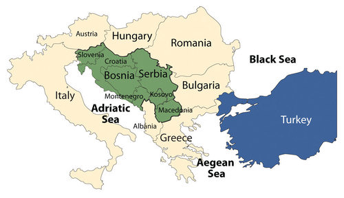 Macedonia is officially called the Former Yugoslav Republic of Macedonia (FYROM) because of a name conflict with Greece. Albania is an independent country and was never a part of Yugoslavia.
Status of States in Former Yugoslavia
| Country | Year of Independence | Religion | Population | Size (square miles) | World War II Ally |
| Slovenia | 1991 | Catholic, 57%; Muslim, 2.4%;Orthodox, 2.3% | 2 million | 7,827 (about the size of Vermont) | — |
| Croatia | 1991 | Catholic, 88%; Orthodox, 4.4%; Muslim, 1.3% | 4.5 million | 21,831 (about the size of West Virginia) | Nazi Germany |
| Bosnia | 1991 | Muslim, 40%; Orthodox, 31%; Catholic, 15% | 4 million | 19,741 (about the size of West Virginia) | — |
| Serbia | 2006 | Orthodox, 85%; Muslim, 4%; Other, 10% | 10 million | 29,915 (about the size of South Carolina) | Soviet Union |
| Kosovo* | 2008 | Muslim, 90%; Orthodox, 9% | 1.8 million | 4,203 (about the size of Connecticut) | — |
| Macedonia | 1991 | Orthodox, 67%; Muslim, 30% | 2.1 million | 9,781 (about the size of Vermont) | — |
| Montenegro | 2006 | Orthodox, 74%; Muslim, 18%; Catholic, 3.5% | 678,177 | 5,423 (about the size of Connecticut) | — |
| *Note: As of 2008, Kosovo was not accepted by the UN. Its status is pending. | |||||
The Breakup of Former Yugoslavia
Tito died in 1980. The unity that had helped hold the country together began to break down in the early 1990s with the Soviet Union’s collapse. With the dual loss of the Soviet Union and Tito’s strong policies as centripetal forces, the power struggle for dominance among the various ethnic groups began.
In 1991, Slobodan Miloševik began pushing for the nationalistic goal of uniting all the ethnic Serbs that lived in the various parts of Yugoslavia into a Greater Serbia. The efforts were not approved or supported by the UN, which rejected Yugoslavia for membership in 1992. At that time, Kosovo and Montenegro were part of the Serb state. Miloševik first sent the Yugoslav military to Kosovo to take control of the majority Albanian population and secure the region for Greater Serbia. Fearing war, Slovenia, Croatia, and Macedonia declared independence in 1991. Yugoslavia was breaking up.
Miloševik then moved into Croatia to secure Serb areas for his Greater Serbia. After a brief but bitter war between Serbia and Croatia, the UN stepped in to halt the conflict. The first signs of ethnic cleansing were reported during this conflict. Serb military units would roll into a town or village and claim it as a Serb-only location. The Croats and any other people living there were forced to leave.
Reports of assaults on women and the systematic killing of men of fighting age were documented. Sadly, ethnic cleansing began to be reported on all sides of the war. The bitter hatred between Croats and Serbs, which had been handed down from the World War II era, surfaced for a new generation. After the UN stopped Miloševik in Croatia, he turned to the Serb areas of Bosnia to expand his Greater Serbia. Bosnia immediately declared independence and was approved by the UN in 1992.
The battle for Bosnia extended from 1992 to 1995, and Europe wondered if the Bosnian war would develop into World War III. The region of Bosnia included people of Serb, Croat, and Bosnian ethnic backgrounds. Bosnia broke up along ethnic lines. The Serb group supported Greater Serbia and the Bosnian group wanted independence. In March 1994, the Croat group signed an agreement joining with the Bosnian group against the Serbs.
In 1995, with strong pressure from Europe and the United States, the warring groups signed a peace agreement known as the Dayton Accord, named after a meeting in Dayton, Ohio. The Dayton Accord accepted Bosnia’s borders and supported the creation of a unity government that was democratic and included the multiethnic groups. The country of Bosnia was divided into three parts: Serb, Croat, and Bosnian.
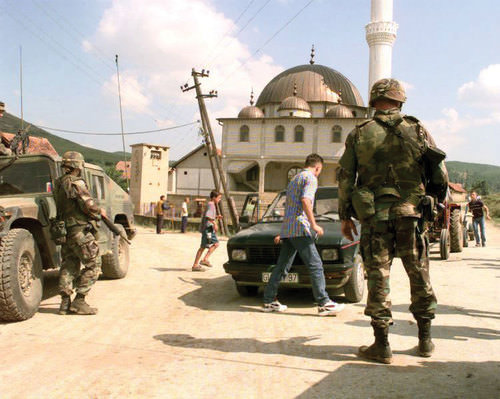 This photo shows the checkpoint in Kosovo in 2004.
Military forces continue to monitor and secure the regions of Bosnia. Portions of Bosnia under Serb control have declared themselves the Republic of Srpska and have attempted to create their own nation-state. The remaining territory of Bosnia (51 percent) consists of a joint Bosnian/Croat Federation. Both regions have sub-level governments within the formal country of Bosnia and Herzegovina.
Herzegovina is a small region extending from the city of Mostar to the southern border with Montenegro. In June of 2006, the region of Montenegro declared itself independent of Serbia. Montenegro uses the euro as its currency and has applied for the World Trade Organization (WTO) membership. Montenegro has privatized its main industries and is working on developing a tourism industry.
The War for Kosovo
Yugoslavia, under the leadership of President Miloševik, sought to ensure that Kosovo would never leave the umbrella of Greater Serbia. The Albanian Muslims who lived in Kosovo made up 90 percent of the population by 1989. They did not want to live under Serb control. Serbia claimed that Kosovo was the heart of the Serb Orthodox Church and the cradle of the medieval Serbian Empire. The historic battles against the Islamic Turkish Ottoman Empire in Kosovo have been memorialized in Serb tradition and history.
The main opposition to the Serb power structure in Kosovo in the early 1990s was the Kosovo Liberation Army (KLA). Many in the KLA wanted an independent Kosovo and an alliance with Albania. In 1998, Miloševik sent troops into areas controlled by the KLA. The civil war in Kosovo between Serbs and Albanian Muslims was devastating the region and creating thousands of refugees. The tension, hatred, and massacres by both forces further complicated the peace process. In March of 1999, NATO implemented a mission called Operation Allied Force to force Miloševik to discontinue the ethnic cleansing campaign and end the violence in Kosovo.
In June of 1999, Miloševik yielded to a peace agreement that brought Kosovo under control of the UN and NATO forces, removed the Serb military, and allowed for the safe return of over 800 thousand refugees from Albania, Montenegro, and Macedonia. Miloševik lost his bid for the presidency in the elections of 2000, was arrested for crimes against humanity in 2001, and was transferred to the International Criminal Tribunal in The Hague, the Netherlands. The charges brought against him included ethnic cleansing and torture. He died in 2006 while in custody before the trial ended.
 The wars in former Yugoslavia were fueled by strong cultural forces.
NATO forces continue to be stationed in Kosovo to keep the peace and work toward restoring order. After much negotiation between the UN and regional entities, the Kosovo Assembly declared its independence from Serbia in 2008. Serb officials overwhelmingly opposed Kosovo’s independence, as they had in 1991. Kosovo’s status is now pending in the UN.
Conclusion of Former Yugoslavia
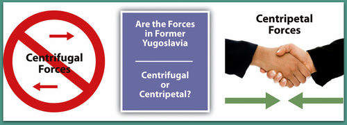
Kosovo and the independent republics of former Yugoslavia provide a study in the dynamics of ethnicity, culture, and political geography. Former Yugoslavia represents an example of how divisive centrifugal and devolutionary forces can lead to nationalism and eventually to war. The drive toward a nation-state has fueled nationalism and conflict in the Balkans. The civil wars within former Yugoslavia have cost thousands of lives and destroyed an infrastructure that had taken decades to build. Geographers have called Eastern Europe a shatter belt because of the conflicts and divisions that have occurred there.
In spite of the problems with the transition in Eastern Europe, the region has nonetheless seen enormous economic gains. Even Slovenia, once part of former Yugoslavia, has rebounded with strong economic growth. Many of the progressive Eastern European countries have been accepted into the EU. The map of the EU includes many of the developing Eastern bloc countries. Eastern Europe has experienced many transitions throughout its history. The transition from communism to capitalism is only one part of the geography and history of Eastern Europe.
- After World War II ended in 1945, Europe was divided into Western Europe and Eastern Europe by the Iron Curtain.
- Western Europe promoted capitalist democracies, and Eastern Europe came under the Communist influence of the Soviet Union.
- After the collapse of the Soviet Union in 1991, Eastern Europe began to transition toward Western European ideals.
- Eastern Europe has been shifting toward democratic governments, open market economies, private ownership, and the EU rather than the old Soviet Union.
- Countries with stable governments and industrial potential have been accepted into the EU and have expanding economies. Other countries that have not reached that level of economic development or political reforms have not been admitted into the EU.
- The transition of former Soviet republics to capitalist systems has not been without difficulties, including unemployment, inflation, corruption and crime, and poverty. Political infighting has been evident in the transitioning countries that do not yet have a stable democratic government or economy.
- The breakup of former Yugoslavia was an example of how strong devolutionary forces can promote nationalism resulting in open war.
- The once stable country of Yugoslavia split into seven separate countries patterned after the nation-state concept. Bosnia remains the most diverse state, with a majority Muslim population.
Vocabulary Terms
| Balkanization | The process of breaking up a region into small, mutually hostile units |
| Ethnic Cleansing | The policy of trying to eliminate an ethnic group |
Applying Knowledge
Interactive Notebook Activity
- What were four of the main reforms that occurred in Eastern Europe with the collapse of the Soviet Union?
- Which Eastern European countries were once members of the Soviet Union?
- What factor has most heavily influenced most of the political boundaries of Eastern Europe?
- How would the change from central planning to open markets influence the use of natural resources?
- Which countries of Eastern Europe are members of the EU?
- How did the larger Slavic population of former Yugoslavia 500 years ago become the existing subgroups of the Slovenes, Croats, Bosnians, Montenegrins, and Serbs?
- Why was Slobodan Miloševik so determined to keep the region of Kosovo under Serb control?
- What was the purpose of ethnic cleansing in former Yugoslavia?
- What role did religion play in the wars in Bosnia and Kosovo?
- Why would the United States be so concerned about the wars in Bosnia and Kosovo—so much so that the United States spent billions to help end the war and to keep the peace and rebuild the region?
Real-World Geography Exercise
Using Google Maps, locate the places below. Then, choose one area for which you will create a SWAY or a PowerPoint presentation. Include important facts, images, maps, and videos.
- Albania
- Belarus
- Bosnia
- Croatia
- Czech Republic
- Estonia
- Hungary
- Kosovo
- Latvia
- Lithuania
- Macedonia
- Moldova
- Montenegro
- Poland
- Romania
- Serbia
- Slovakia
- Slovenia
- Ukraine
Mapping Exercise
Altered Biomes: Students will investigate the characteristics of major biomes and examine the impact of land-use changes as the result of human activities. Students will utilize online mapping software.
Videos for Geographic Enrichment
Helpful Websites for the Study of Geography
Canadian Encyclopedia is an encyclopedia funded by the Canadian government covering all branches of knowledge. Their scholarly collection includes interactive materials.
CIA World Factbook provides information on the people, history, government, economy, energy, geography, communications, transportation, military, and transnational issues for the world's entities.
Congress.gov is a US government website where you can find federal legislation, past and present, as well as information about the US legal system.
Drug Enforcement Administration (DEA) is a government agency website that provides current news, resources, topics of interest, information about drugs, careers in the DEA, and a tip hotline.
Library of Congress is the largest library in the world and provides manuscripts, files, information, pictures, and videos.
NASA Earth Observatory (NEO) is a US government agency website that allows users to search for and retrieve satellite images of Earth.
National Archives is a US government website that provides historical documents, photos, records, publications, and educator resources.
National Oceanic and Atmospheric Association (NOAA) is a US government agency website that provides weather-related information and ocean research.
National Map is a website by the United States Geological Survey and other federal, state, and local agencies that delivers topographic information for the United States.
NationMaster is a massive central data source and a handy way to graphically compare nations.
Real-Time World Air Quality Index is a website that measures most locations in the world for air pollution in real time.
StateMaster is a unique statistical database, which allows you to research and compare a multitude of different data on US states.
United Nations (UN) is an international organization founded in 1945 and made up of 193 member states. The UN maintains international peace and security, protects human rights, delivers humanitarian aid, promotes sustainable development, and upholds international law.
United States Census Bureau is a US government agency that provides a population clock, data, surveys, statistics, a library with information and infographics, news about the economy, and much more.
United States Geological Survey (USGS) is a US government agency website that provides scientific information about the natural hazards that threaten lives, the natural resources we rely on, the health of our ecosystems and environment, and the impacts of climate and land-use change.
Whitehouse.gov is a US government website that provides the latest presidential news, information about the budget, policy, defense, and many more topics.
World Health Organization (WHO) is under the United Nations and provides leadership on matters critical to health, shapes the research agenda on health, and monitors the health situation and assessing health trends around the world. Their website provides information on the state of health around the world, outbreaks, current health news, and more.
World Trade Organization (WTO) is an intergovernmental organization that regulates international trade. The website provides information on the history of the multilateral trading system, featured videos, news and events, trade topics, and more.
Investigate the characteristics of major biomes and examine the impact of land-use changes as the result of human activities.
| Image | Reference | Attributions |
|
[Figure 1] | Credit: http://open.lib.umn.edu/worldgeograp...astern-europe/ Source: open.lib.umn.edu/worldgeography/wp-content/uploads/sites/181/2016/04/65229d6ac18089b1680a1051beb858d6.jpg License: CC BY-NC 3.0 |
|
[Figure 2] | Credit: http://open.lib.umn.edu/worldgeograp...astern-europe/ Source: open.lib.umn.edu/worldgeography/wp-content/uploads/sites/181/2016/04/28675c8de1c599a25931a08d55f6c1a8.jpg License: CC BY-NC 3.0 |
|
[Figure 3] | Credit: cia world factbook Source: https://www.cia.gov/library/publications/the-world-factbook/geos/hu.html License: CC BY-NC 3.0 |
|
[Figure 4] | Credit: Wikimedia Commons – CC BY 2.0. Source: open.lib.umn.edu/worldgeography/wp-content/uploads/sites/181/2016/04/28e1322b040b0bc7b6547438c5cc87c2.jpg License: CC BY-NC 3.0 |
|
[Figure 5] | Credit: cia world factbook Source: https://www.cia.gov/library/publications/the-world-factbook/geos/lo.html License: CC BY-NC 3.0 |
|
[Figure 6] | Credit: Wikimedia Commons – public domain. Source: open.lib.umn.edu/worldgeography/wp-content/uploads/sites/181/2016/04/49ac1f762c54924a5be3ff7421c90503.jpg License: CC BY-NC 3.0 |
|
[Figure 7] | Credit: cia world factbook Source: https://www.cia.gov/library/publications/the-world-factbook/geos/up.html License: CC BY-NC 3.0 |
|
[Figure 8] | Credit: cia world factbook Source: https://www.cia.gov/library/publications/the-world-factbook/geos/ro.html License: CC BY-NC 3.0 |
|
[Figure 9] | Credit: Wikimedia Commons – public domain. Source: open.lib.umn.edu/worldgeography/wp-content/uploads/sites/181/2016/04/ec540a7860efd5b1f7ec4f357ca371ef.jpg License: CC BY-NC 3.0 |
|
[Figure 10] | Credit: cia world factbook Source: https://www.cia.gov/library/publications/the-world-factbook/geos/al.html License: CC BY-NC 3.0 |
|
[Figure 11] | Credit: cia world factbook Source: https://www.cia.gov/library/publications/the-world-factbook/geos/bu.html License: CC BY-NC 3.0 |
|
[Figure 12] | Credit: http://open.lib.umn.edu/worldgeograp...astern-europe/ Source: open.lib.umn.edu/worldgeography/wp-content/uploads/sites/181/2016/04/3549951f95750a37b6ab7aed1b8ce769.jpg License: CC BY-NC 3.0 |
|
[Figure 13] | Credit: U.S. Military – public domain. Source: open.lib.umn.edu/worldgeography/wp-content/uploads/sites/181/2016/04/65720bfe631239b8c5684cf02e5db596.jpg License: CC BY-NC 3.0 |
|
[Figure 14] | Credit: http://open.lib.umn.edu/worldgeograp...astern-europe/ Source: Saylor URL: http://www.saylor.org/books ; http://open.lib.umn.edu/worldgeography/chapter/2-4-eastern-europe/ License: CC BY-NC 3.0 |