
7.1: Southwest Asia- Introducing the Realm (2 Days)
- Page ID
- 1969
\( \newcommand{\vecs}[1]{\overset { \scriptstyle \rightharpoonup} {\mathbf{#1}} } \)
\( \newcommand{\vecd}[1]{\overset{-\!-\!\rightharpoonup}{\vphantom{a}\smash {#1}}} \)
\( \newcommand{\dsum}{\displaystyle\sum\limits} \)
\( \newcommand{\dint}{\displaystyle\int\limits} \)
\( \newcommand{\dlim}{\displaystyle\lim\limits} \)
\( \newcommand{\id}{\mathrm{id}}\) \( \newcommand{\Span}{\mathrm{span}}\)
( \newcommand{\kernel}{\mathrm{null}\,}\) \( \newcommand{\range}{\mathrm{range}\,}\)
\( \newcommand{\RealPart}{\mathrm{Re}}\) \( \newcommand{\ImaginaryPart}{\mathrm{Im}}\)
\( \newcommand{\Argument}{\mathrm{Arg}}\) \( \newcommand{\norm}[1]{\| #1 \|}\)
\( \newcommand{\inner}[2]{\langle #1, #2 \rangle}\)
\( \newcommand{\Span}{\mathrm{span}}\)
\( \newcommand{\id}{\mathrm{id}}\)
\( \newcommand{\Span}{\mathrm{span}}\)
\( \newcommand{\kernel}{\mathrm{null}\,}\)
\( \newcommand{\range}{\mathrm{range}\,}\)
\( \newcommand{\RealPart}{\mathrm{Re}}\)
\( \newcommand{\ImaginaryPart}{\mathrm{Im}}\)
\( \newcommand{\Argument}{\mathrm{Arg}}\)
\( \newcommand{\norm}[1]{\| #1 \|}\)
\( \newcommand{\inner}[2]{\langle #1, #2 \rangle}\)
\( \newcommand{\Span}{\mathrm{span}}\) \( \newcommand{\AA}{\unicode[.8,0]{x212B}}\)
\( \newcommand{\vectorA}[1]{\vec{#1}} % arrow\)
\( \newcommand{\vectorAt}[1]{\vec{\text{#1}}} % arrow\)
\( \newcommand{\vectorB}[1]{\overset { \scriptstyle \rightharpoonup} {\mathbf{#1}} } \)
\( \newcommand{\vectorC}[1]{\textbf{#1}} \)
\( \newcommand{\vectorD}[1]{\overrightarrow{#1}} \)
\( \newcommand{\vectorDt}[1]{\overrightarrow{\text{#1}}} \)
\( \newcommand{\vectE}[1]{\overset{-\!-\!\rightharpoonup}{\vphantom{a}\smash{\mathbf {#1}}}} \)
\( \newcommand{\vecs}[1]{\overset { \scriptstyle \rightharpoonup} {\mathbf{#1}} } \)
\(\newcommand{\longvect}{\overrightarrow}\)
\( \newcommand{\vecd}[1]{\overset{-\!-\!\rightharpoonup}{\vphantom{a}\smash {#1}}} \)
\(\newcommand{\avec}{\mathbf a}\) \(\newcommand{\bvec}{\mathbf b}\) \(\newcommand{\cvec}{\mathbf c}\) \(\newcommand{\dvec}{\mathbf d}\) \(\newcommand{\dtil}{\widetilde{\mathbf d}}\) \(\newcommand{\evec}{\mathbf e}\) \(\newcommand{\fvec}{\mathbf f}\) \(\newcommand{\nvec}{\mathbf n}\) \(\newcommand{\pvec}{\mathbf p}\) \(\newcommand{\qvec}{\mathbf q}\) \(\newcommand{\svec}{\mathbf s}\) \(\newcommand{\tvec}{\mathbf t}\) \(\newcommand{\uvec}{\mathbf u}\) \(\newcommand{\vvec}{\mathbf v}\) \(\newcommand{\wvec}{\mathbf w}\) \(\newcommand{\xvec}{\mathbf x}\) \(\newcommand{\yvec}{\mathbf y}\) \(\newcommand{\zvec}{\mathbf z}\) \(\newcommand{\rvec}{\mathbf r}\) \(\newcommand{\mvec}{\mathbf m}\) \(\newcommand{\zerovec}{\mathbf 0}\) \(\newcommand{\onevec}{\mathbf 1}\) \(\newcommand{\real}{\mathbb R}\) \(\newcommand{\twovec}[2]{\left[\begin{array}{r}#1 \\ #2 \end{array}\right]}\) \(\newcommand{\ctwovec}[2]{\left[\begin{array}{c}#1 \\ #2 \end{array}\right]}\) \(\newcommand{\threevec}[3]{\left[\begin{array}{r}#1 \\ #2 \\ #3 \end{array}\right]}\) \(\newcommand{\cthreevec}[3]{\left[\begin{array}{c}#1 \\ #2 \\ #3 \end{array}\right]}\) \(\newcommand{\fourvec}[4]{\left[\begin{array}{r}#1 \\ #2 \\ #3 \\ #4 \end{array}\right]}\) \(\newcommand{\cfourvec}[4]{\left[\begin{array}{c}#1 \\ #2 \\ #3 \\ #4 \end{array}\right]}\) \(\newcommand{\fivevec}[5]{\left[\begin{array}{r}#1 \\ #2 \\ #3 \\ #4 \\ #5 \\ \end{array}\right]}\) \(\newcommand{\cfivevec}[5]{\left[\begin{array}{c}#1 \\ #2 \\ #3 \\ #4 \\ #5 \\ \end{array}\right]}\) \(\newcommand{\mattwo}[4]{\left[\begin{array}{rr}#1 \amp #2 \\ #3 \amp #4 \\ \end{array}\right]}\) \(\newcommand{\laspan}[1]{\text{Span}\{#1\}}\) \(\newcommand{\bcal}{\cal B}\) \(\newcommand{\ccal}{\cal C}\) \(\newcommand{\scal}{\cal S}\) \(\newcommand{\wcal}{\cal W}\) \(\newcommand{\ecal}{\cal E}\) \(\newcommand{\coords}[2]{\left\{#1\right\}_{#2}}\) \(\newcommand{\gray}[1]{\color{gray}{#1}}\) \(\newcommand{\lgray}[1]{\color{lightgray}{#1}}\) \(\newcommand{\rank}{\operatorname{rank}}\) \(\newcommand{\row}{\text{Row}}\) \(\newcommand{\col}{\text{Col}}\) \(\renewcommand{\row}{\text{Row}}\) \(\newcommand{\nul}{\text{Nul}}\) \(\newcommand{\var}{\text{Var}}\) \(\newcommand{\corr}{\text{corr}}\) \(\newcommand{\len}[1]{\left|#1\right|}\) \(\newcommand{\bbar}{\overline{\bvec}}\) \(\newcommand{\bhat}{\widehat{\bvec}}\) \(\newcommand{\bperp}{\bvec^\perp}\) \(\newcommand{\xhat}{\widehat{\xvec}}\) \(\newcommand{\vhat}{\widehat{\vvec}}\) \(\newcommand{\uhat}{\widehat{\uvec}}\) \(\newcommand{\what}{\widehat{\wvec}}\) \(\newcommand{\Sighat}{\widehat{\Sigma}}\) \(\newcommand{\lt}{<}\) \(\newcommand{\gt}{>}\) \(\newcommand{\amp}{&}\) \(\definecolor{fillinmathshade}{gray}{0.9}\)- Understand three basic traits the countries of the realm shares in common.
- Outline the two cultural hearths and explain why they developed where they did.
- Describe how the people of this realm gain access to fresh water.
- Understand how the events of the 2011 Arab Spring have affected the realm.
TEKS Regional Unit 07 Southwest Asia: Chapter 7.1 Introducing the Realm
WG.1A Analyze the effects of physical and human geographic patterns and processes on the past and describe their impact on the present, including significant physical features and environmental conditions that influenced migration patterns and shaped the distribution of culture groups today.
WG.2A Describe the human and physical characteristics of the same regions at different periods of time to evaluate relationships between past events and current conditions.
WG.6B Explain the processes that have caused changes in settlement patterns, including urbanization, transportation, access to and availability of resources, and economic activities.
WG.8A Compare ways that humans depend on, adapt to, and modify the physical environment, including the influences of culture and technology.
WG.8C Evaluate the economic and political relationships between settlements and the environment, including sustainable development and renewable/non-renewable resources.
WG.12A Analyze how the creation, distribution, and management of key natural resources affects the location and patterns of movement of products, money, and people.
WG.12B Evaluate the geographic and economic impact of policies related to the development, use, and scarcity of natural resources such as regulations of water.
WG.14A Analyze current events to infer the physical and human processes that lead to the formation of boundaries and other political divisions.
WG.16C Explain ways various groups of people perceive the characteristics of their own and other cultures, places, and regions differently.
WG.19C Examine the environmental, economic, and social impacts of advances in technology on agriculture and natural resources.
WG.21C Create and interpret different types of maps to answer geographic questions, infer relationships, and analyze change.
WG.22C Use geographic terminology correctly.
WG.22D Use standard grammar, spelling, sentence structure, and punctuation.
TEKS and ELPS for Regional World Geography Unit 07-Southwest Asia from TEKS Resource System
Southwest Asia: Introducing the Realm
The countries of the realm share three key dominant traits that influence all other human activities. The first key common trait relates to the climate of the region. Though various climate types can be found in this realm, it is the dry or arid type B climate that dominates most of the physical area. Other climate types include the type H highland climate (cold temperatures at the high elevations with moderate temperatures at the bases) of the mountains of the Maghreb, Iran, or Central Asia and the more moderate type C climate in the coastal regions bordering the sea. The type C climate along the coastal Mediterranean area attracts human development and is home to many large port cities.
The overall fact is that vast areas of each region are uninhabited desert. North Africa has the largest desert in the world—the Sahara—which borders the Libyan Desert and the Nubian Desert. About one-third of the Arabian Peninsula is part of the Empty Quarter of the Rub’ al Khali (Arabian Desert). Kazakhstan, Uzbekistan, and Turkmenistan have vast regions of desert with few if any inhabitants. This aspect of the realm reveals the importance of water as a valuable natural resource. Most people in the realm are more dependent on the availability of water than on the availability of oil.
The second trait is the religion of Islam. Most of the people in the realm are Muslims. The practice of Islam in day-to-day life takes different forms in the various divisions of the religion. The differences between the divisions have contributed to conflict or open warfare. Islam serves as more than a religion. It also acts as a strong cultural force that has historically unified or divided people. The divisive nature of the religion has often resulted in serious political confrontations within the realm between groups of different Islamic ideologies.
Concurrently, the religion of Islam is also a unifying force that brings Muslims with similar beliefs together. Islam provides structure and consistency in daily life. The faith can provide comfort and a way of living. The holy cities of Mecca and Medina are located in Saudi Arabia. Other holy cities for other divisions of Islam include Jerusalem and the two cities holy to Shia Muslims: Karbala and Najaf in Iraq. Islam dominates the realm, but other religions are significant in various regions. Israel is a Jewish state, and Christianity is common in places from Lebanon to Egypt. There are also followers of the Baha’i faith, Zoroastrianism, and groups such as the Druze, just to name a few.
The third factor that all three regions of the realm share is the availability of significant natural resources. North Africa, Southwest Asia, and Turkestan all have significant reserves of oil, natural gas, and important minerals. It stands to reason that not every country has the same reserves and that some of the countries have very few or none at all. However, in terms of how the countries gain national wealth, it is the export of oil that has dominated the economic activity as it relates to the global community.
This realm is a peripheral realm. The resource that the realm can offer to the core economic regions of the world is the energy to fuel their economies and maintain their high standard of living. Enormous economic profits from the sale of these resources have traditionally been held in the hands of the elite ruling leader or his clan and do not always filter down to most of the population. The control of and profits from natural resources have become the primary objectives of the countries. This fuels conflicts and armed military interventions in areas such as Iraq and Afghanistan.
Cultural Hearths
Availability and control of fresh water have typically resulted in the ability of humans to grow food crops and expand their cultural activities. Hunter-gatherer groups did not settle down in one area but were more nomadic because of their seasonal search for food. As humans developed the ability to grow crops and provide enough food in one place, they no longer needed to move. The earliest human settlements sprang up in what is the present-day Middle East.
Early human settlements provide some indication of early urbanization patterns based on the availability or surplus of food. The shift to permanent settlements included the domestication of livestock and the production of grain crops. Fruits and vegetables were grown and harvested domestically. The activities of this era created humanity’s earliest version of the rural-to-urban shift associated with the Industrial Revolution or present development. It is theorized that the ability to grow excess food provided the time and resources for urbanization and the establishment of organized communities, which often progressed into political entities or regional empires.
It has been estimated that some of the earliest cities in the world—Jericho, for example—were first inhabited around 10,000 B.C.E. in the Middle East. In the same region, two cultural hearths provide significant historical value to the concept of human development, Mesopotamia and the Nile Valley in Egypt. Both areas were settings for the growth of human civilization and are still being examined and studied today. In Mesopotamia, a remarkable human civilization emerged along the banks of the Tigris and Euphrates Rivers in what is present-day Iraq, Syria, and southern Turkey. The climate, soils, and availability of fresh water provided the ingredients for the growth of a human civilization.
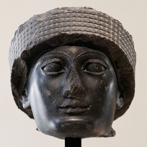 Head of Gudea, Sumerian ruler from Mesopotamia, circa 2121 B.C.E.
Mesopotamia and the Fertile Crescent
Mesopotamia, meaning “land between rivers,” is located between the Tigris and Euphrates Rivers. Neolithic pottery found there has been dated to before 7000 B.C.E. Humans in this area urbanized as early as 5000 B.C.E. People were settling in the Mesopotamia region, building magnificent cities, and developing their sense of human culture. Mesopotamia gave rise to a historical cradle of civilization that included the Assyrian, Babylonian, Sumerian, and Akkadian Empires, all established during the Bronze Age (about 3000 B.C.E. or later).
Famous cities such as Ur, Babylon, and Nineveh were located in the Mesopotamia region. The control of water and the ability to grow excess food contributed to their success. They developed extensive irrigation systems. Large grain storage units were necessary to provide the civic structure and to develop a military to protect and serve the city or empire. The human activity in this area extended around the region all the way to the Mediterranean Sea, which is where the term Fertile Crescent comes from.
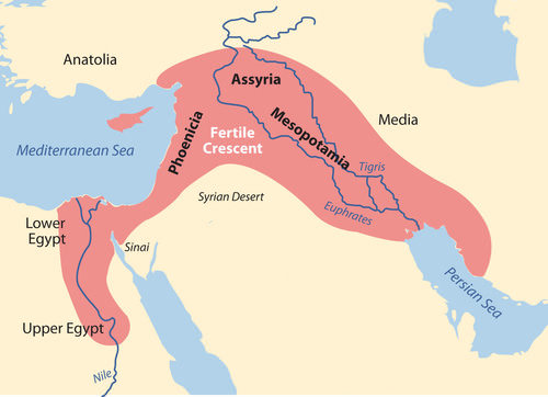 The two main cultural hearths in the realm: Mesopotamia and the Fertile Crescent in Asia and upper and lower Egypt in Africa.
Various ancient groups were well established on the eastern side of the Fertile Crescent along the Mediterranean coast. The cities of Tyre and Sidon were ports and access points for trade and commerce for groups like the Phoenicians who traded throughout the Mediterranean. Ancient cities such as Damascus and Jericho became established in the same region and were good examples of early human urbanization during the Bronze Age. These cities are two of the oldest in the world.
Nile River Civilization
Human civilization also emerged along the Nile River valley of what is now Egypt. The pyramids and the Sphinx in the Giza Plateau just outside Cairo stand testimony to the human endeavors that took place here. Spring flooding of the Nile River brought nutrients and water to the land along the Nile Valley. The land could produce excess food, which led to the ability to support a structured, urbanized civilization. The Nile River is the lifeblood of the region.
In the fifth century B.C.E., the ancient Greek historian Herodotus suggested that Egypt was “the gift of the Nile.” The dating for the beginning of the civilization along the Nile River is often in question, but Egyptologists estimate the first dynasty ruled both Upper and Lower Egypt around 3100 B.C.E. Upper Egypt is in the south and Lower Egypt is in the north because the Nile River flows north. The terms “Upper” and “Lower” refer to elevation. Geologists, using the erosion patterns of the Sphinx, estimate that it was constructed about 10,000 B.C.E.
The ability of humans to harness the potential of the environment set the stage for technological advancements that continue to this day. The Egyptian civilization flourished for thousands of years and gave birth to a legacy that influenced and benefitted their neighbors.
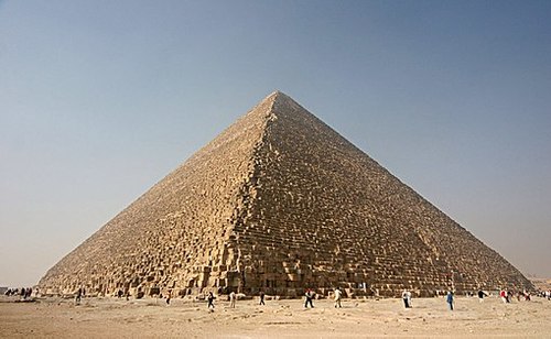 This photo shows the Great Pyramid at Giza. Photo credit: Nina Aldin Thune
The human activities that created the civilizations in Mesopotamia and along Egypt’s Nile River gave humanity a rich heritage. Many of our legends, stories, and myths have their origins in these cultures. Their cultural developments provided the basis for much of the Western world’s religious beliefs and early philosophical ideas. The engineering feats needed to create the magnificent temples and pyramids have by themselves been studied and analyzed over the centuries. Scientists and scholars recognize the high level of organization and structure that went into developing and managing these civilizations.
Various aspects of science and the arts were being developed by these ancient people. Writing, mathematics, engineering, and astronomy were becoming highly advanced. Artifacts such as clay tablets and hieroglyphs are still being discovered and interpreted. They shed additional light on the advancements of these civilizations and their contribution to our human civilization.
Access to Fresh Water
Water is one of the necessities for human existence. Human settlements have long been based on the availability of water for consumption, agriculture, navigation, and the production of energy. In North Africa and Southwest Asia, the availability of water has an even greater relevance because of the dominant type B climate. Methods used to address the shortage of water or to access fresh water have been nearly as diverse as the people who live here. Large populations of people can be found wherever there is fresh water.
Water has historically been transferred from source to destination through canals, aqueducts, or special channels. Many ruins of extensive aqueducts from Roman times and earlier remain throughout the realm. The issues associated with water use continue to affect the lives of the people of this realm. Rapid population growth and industrialization have intensified the demand for fresh water.
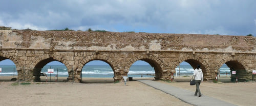 This photo shows the Roman aqueduct near Caesarea.
Water can be found in the desert regions in a range of forms. For example, there are oases, springs, or noted wells from which people can draw underground water that is close to the surface. Mountainous regions such as the Atlas Mountains in North Africa or the Elburz Mountains in Iran trap moisture, which produces higher quantities of precipitation. The precipitation is then available in the valleys to irrigate crops. Discovering or developing other methods of acquiring fresh water is a requirement in areas without mountains.
Underground Water in Libya
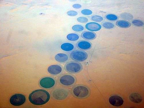 This photo shows the Libyan pivot irrigation in Al Kufrah, southeast Cyrenaica. Wealth from oil has enabled Libya to build projects such as agriculture in the Sahara desert.
In the Sahara region, Libya draws water from deep underground wells that tap into the vast aquifers beneath the desert. These aquifers were charged with water when the region had a tropical climate thousands of years ago. The water is referred to as fossil water. Extensive systems of canals and pipelines have been developed in Libya to extract fossil water and use it for agricultural production or for urban purposes. The man-made river project, one of the largest of its kind, has drawn fresh water from the desert to large cities such as Tripoli and Benghazi.
The local drinking water in Benghazi is contaminated by saltwater intrusion from the Mediterranean. Underground aquifers are underneath political boundaries, so the allocation and control of water are matters of political debate with the potential to lead to military conflict. The project’s potential duration will be a function of how quickly the water is used and how many people use the aquifer system.
The main problem with this system is that underground aquifers are not considered a renewable resource. As more countries tap into the aquifers, the available water will be depleted more quickly. As water is drawn from the aquifers for industrial irrigation, the water table goes down. Local settlements that rely on well water may in time have to dig deeper wells or move to locations where water resources are still available.
Nile Water in Egypt
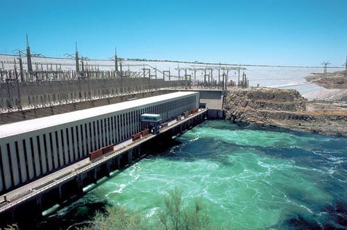 The Aswan Dam is an embankment dam situated across the Nile River in Aswan, Egypt.
Egypt draws water from the Nile to irrigate fields for extensive food production. For thousands of years, floods of the Nile annually covered the land with fresh silt and water. This made the land productive, but the flooding often caused serious damage to human infrastructure. The building of the Aswan High Dam in the 1970s helped control the flooding of the Nile Valley. The river no longer flooded annually, and water had to be pumped onto the land.
Over time, the constant and extensive use of this type of irrigation causes the small quantities of salt in the water to build up in the soil to serious levels, thereby reducing the land’s productivity. This process, called salinization, is a common problem in arid climates. To rid the soil of the salts, fresh water is needed to flood the fields, dissolving the salt and then moving the salty water back off the fields.
High salinization in the soil and the reduction in agricultural productivity is a growing concern for Egypt. Egypt’s growing population places a high demand on the availability of food. More than half of the 80 million people in Egypt live in rural areas. Many of them make their living in agriculture growing food that plays a critical role in the country’s economic stability
Water from the Tigris and Euphrates
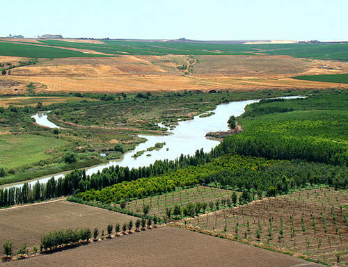 The Tigris is an important river for agriculture just outside Diyarbakır.
The major source of water in the Fertile Crescent region comes from the Tigris and Euphrates rivers. Both have their origins in Turkey and converge at the Shatt al-Arab waterway that flows into the Persian Gulf. The Euphrates is the longest river in Southwest Asia and flows through Syria from Turkey before entering into Iraq. Turkey had developed large dams on both the Tigris and Euphrates for agricultural purposes and to generate hydroelectric power.
As water is diverted for agriculture in Turkey, there is less water flowing downstream for Syria or Iraq. Disputes over water resources continue to be a major concern in the Tigris-Euphrates Basin. The Atatürk Dam in Turkey is largest dam on the Euphrates, and it has a reservoir behind the dam that is large enough to hold the total annual discharge of the river. All three countries have dams on the Euphrates and both Turkey and Iraq have dams on the Tigris.
The three countries signed a memorandum of understanding in 2009 to strengthen cooperation within the Tigris-Euphrates Basin. All three countries need water for agriculture to produce food for a growing population. Agreements to share water have been difficult as a result of the Iraq War and the recent protests and demonstrations in Syria that have contributed to further political tension between the three countries.
Water Conservation in Israel
Israel has taken innovative steps to conserve water and use it efficiently. Drip irrigation mixed with fertilizers is called fertigation. Fertigation is used extensively in the area. Israel grows plantation crops such as bananas, which require large quantities of water. Banana groves are covered with material that allows sunlight to penetrate but reduces the amount of transpiration, which conserves water.
Israel has worked to recycle water whenever possible. Gray water is water extracted from sewage that has been treated to be used in agriculture. Underground wells in the West Bank region provide water for a high percentage of people in both the Palestinian areas and Israel. The issue of control over the water is contentious at times. Just as the control of water may have been an important factor in the early Mesopotamian civilizations, it remains a point of political conflict in places such as Israel and the West Bank.
The lack of fresh water and the heavier demand placed on water resources have caused countries that can afford it to desalinize seawater. This process is used extensively in the oil-rich states of the Arabian Peninsula. Israel is implementing a similar plan to accommodate its increasing population and fresh water requirements.
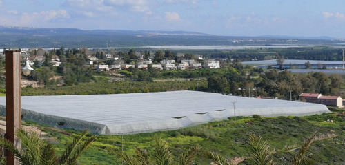 This banana grove in Israel near the Lebanese border is covered with material that allows sunlight to penetrate but helps reduce the loss of water through transpiration.
Mountain Water in Iran
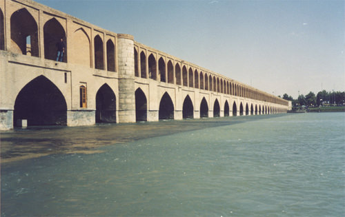 The Zayandeh River as it passes under the bridge in Isfahan, Iran.
Iran is largely a desert climate. Thus, most of the country does not receive large amounts of precipitation. In an effort to redistribute the water available from the high mountains, Iranians have developed a system of qanats to collect water where it is available and channel it to the cities or urban areas for use. A qanat might include a system of shafts or wells along a mountain slope that allows water to collect into a common underground channel, which is then diverted to wherever it is needed.
This system has been in use since ancient times in many arid regions of the realm and around the world. More than 2,700 years ago, a qanat was developed in what is present-day Iran. The qanat has a system of hundreds of wells and channels water for more than 28 miles. It still provides drinking water to more than 40,000 people in the city of Gonabad. Thousands of qanats were developed over the centuries in this area. Persians used cold qanat water from the mountains to keep ice cool during the summer months. Agricultural production relies heavily on water from qanats, which are dependent on climate conditions and local weather patterns.
Water Shortages in Arabia
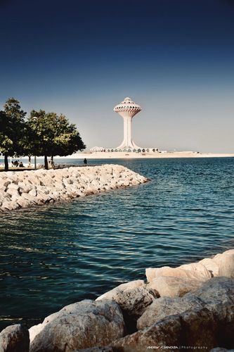 This photo shows the Khobar Water Tower in Saudi Arabia.
The Arabian Peninsula has underground aquifers of fossil water located beneath the sands like the ones in the Sahara Desert. Saudi Arabia taps into these water resources to irrigate agricultural land to grow food. This area faces the same issue as Libya and other areas of the world that rely on underground aquifers. Eventually, the water supply will be used up. The majority of the Arabian Peninsula is desert and water is always in short supply.
Many coastal desert countries such as the United Arab Emirates (UAE), Bahrain, and Qatar utilize the desalinization process of seawater for their needs. However, this works only as long as the country can afford the energy cost required to operate the desalinization plants.
Yemen is a state on the Arabian Peninsula that is mountainous and has used terraced farming to benefit from the precipitation they receive. Water from precipitation is trapped in terraces, and as it flows down the mountainside, each terrace uses what it needs and then passes the water to the next lower terrace. More land can be farmed to produce higher yields of agricultural crops such as sorghum and cereals.
One of the main problems with Yemen’s terrace system is that most of its trees are being cut down for firewood. Tree roots are essential for holding the soil together on the fragile mountain slopes. Another problem is heavy rains that cause serious erosion and damage to the terrace system. Additionally, the extremely rapid growth rate of Yemen’s population is outstripping its agricultural production.
Diversion of Water in Turkestan
Fresh water is in short supply in many of the desert regions of Turkestan in Central Asia. Agricultural production has traditionally been dependent on water flowing in rivers and streams that originated with the precipitation from the mountains. As humans have developed canals and irrigation systems, water from rivers has been diverted for agricultural use. Vast fields of cash crops such as cotton were developed during the Soviet era and the result had devastating consequences for the Aral Sea, which depended on the water. More than one-half of the population of Central Asia depends on agriculture for their livelihood. The other half requires water and food for their existence.
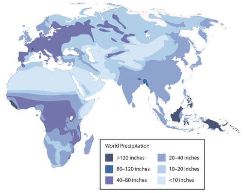 This map illustrates the precipitation patterns for North Africa and Southwest Asia.
Arab Spring of 2011
The year 2011 brought about important changes for the human geography in parts of this realm. Citizens began to speak out against conditions in their country and actively protest against their governments. North Africa, the Middle East, and the Arabian Peninsula experienced the highest levels of protests and insurgency. Political leaders who had been in power for long periods were challenged and removed from office.
Democratic reforms were requested or demanded by citizens seeking more individual freedom and greater access to political power. Uprisings in some of the countries were internal; other countries received external support or intervention. Overall, demonstrations, protests, and outright revolution involved millions of people desiring improved living conditions and a better future for themselves and their families.
Protests emerged in North Africa at the beginning of 2011. Tunisia was the first country in which leadership felt the impact of civil resistance and open revolution. In January, the Tunisian president of more than 23 years was forced to flee to Saudi Arabia. In Egypt, millions of protesters demonstrated in the streets against political corruption and the lack of reforms. The revolution of Egypt’s citizens was not an armed conflict. However, it was an effective protest because it eventually brought about the ousting of President Hosni Mubarak, who had been in office for almost 30 years.
Demonstrations and protests continued against governments in Morocco and Algeria. Citizens voiced their concerns about social problems such as high unemployment, poor living conditions, and government corruption. Libya’s protests erupted into a full-scale armed revolution as anti-government rebels took control of the city of Benghazi in an attempt to topple Muammar Gadhafi’s 42 years of authoritarian control of the government, oil revenues, and the people. The armed Libyan revolution was eventually successful in taking control of Tripoli and in removing Gadhafi and his family from power. The revolution in Libya was aided by the North Atlantic Treaty Organization (NATO) air strikes and the implementation of a no-fly zone over the country.
The ripple effect that the Tunisian revolution had on North Africa was felt on the Arabian Peninsula in places such as Yemen and Bahrain. Mass public demonstrations in Yemen over government corruption, economic conditions, and high unemployment escalated into serious armed conflicts between government troops and opposition factions that wanted the president removed from office. In Bahrain, the protests and demonstrations were centered on the request for more personal freedoms and a greater role in leadership for the Shia population, who experienced discrimination by the Sunni-dominated government. Protests also occurred in Oman for greater reforms.
The Middle East did not escape the Arab Spring of 2011. Protests in Jordan forced King Abdullah II to reorganize his government. Israel and Lebanon were not as affected, as they had been addressing many of these issues on an ongoing basis. The country experiencing the greatest impact was Syria. Major mass demonstrations and serious protests against the government were staged in a number of cities across the country.
In Syria, the long-term leadership of an Alawite minority continues to run the government and control the military. The al-Assad family—a father and then his son—has ruled Syria since 1971. The Syrian government has cracked down on the revolution with hard-line measures aimed at putting down the protests and demonstrations. By September 2011, more than 2,000 protesters had been killed in Syria. Many more were detained or tortured. Countless others have tried to flee to neighboring countries for their safety. The protesters in Syria want democratic reforms as well as the end of the al-Assad family reign.
Other parts of the realm also felt the effects of the Arab Spring of 2011 with mixed results. Iran has had similar protests and demonstrations in past years, but there was not a major revolution or uprising as a direct result of the Arab Spring. Iran is not an Arab country but has experienced ongoing political friction between citizen factions and the government. The wars in Iraq and Afghanistan have tempered or isolated internal protests or revolutionary activities in those countries even though armed conflicts continue.
Various Central Asian states have been working through similar issues but either has not had mass demonstrations or have not received the attention of news media regarding their situations. The wave of change that swept over the realm in the Arab Spring of 2011 is an example of how centripetal and centrifugal cultural forces act on a state or region. The political landscape was altered or drastically changed in many countries. The impact of these changes will be realized in the years and decades to come.
- The realm of North Africa and Southwest Asia extends from the Atlantic Ocean along the Moroccan coast to the western border of China. It includes the regions of North Africa, Southwest Asia, and Central Asia (often referred to as Turkestan).
- Three basic features that dominate this realm include the arid type B climates, Islam as the predominant religion, and the export of petroleum and minerals to gain wealth. There are exceptions to all three features, but these three are found within most countries of the realm.
- The two main cultural hearths in this realm are located along the rivers in Mesopotamia and in Egypt. Control of and access to water resources to grow excess food were the basis for the success of the empires that flourished in these two areas.
- Fresh water is a valuable resource that is not always available in North Africa and Southwest Asia because of the climate and physical geography. Each region within the realm has developed its own methods to draw from or extract the valuable resource of fresh water.
- The Arab Spring of 2011 was a massive wave of protests and demonstrations by citizens of the realm against their governments over such issues as poor living conditions, high unemployment, government corruption, and the lack of democratic reforms. Various leaders were removed from office and governments were pressed to reform their power structures to allow for more shared governance and reduced political corruption.
Vocabulary Terms
|
The location of Turkey. It is located the Black and Mediterranean Seas. |
|
|
A distinctive landform in southwest Asia and the largest peninsula in the world, it is separated from Africa by the Red Sea and from Asia by the Persian Gulf. |
|
|
Run across northwestern Africa, spanning Morocco, Algeria, and Tunisia, separating the Atlantic and Mediterranean coastline from the Sahara Desert. Rich in natural resources such as iron ore, lead ore, copper, silver, mercury, rock salt, phosphate, marble, anthracite coal, and natural gas among other resources. |
|
|
The largest inland sea in the world it is also a salt water lake located between Europe and Asia. |
|
|
A salt lake bordered by Jordan to the east and Israel and Palestine to the west. One of the world's saltiest bodies of water. |
|
|
The longest and one of the most historically important rivers of Western Asia. Together with the Tigris, it is one of the two defining rivers of Mesopotamia. |
|
|
A fertile spot in the desert where water is found. |
|
|
Lies between Iran to the northeast and the Arabian Peninsula to the southwest. It has the world's largest single source of crude oil. |
|
|
Also known as the Empty Quarter, it is the largest contiguous sand desert in the world. Located in Southern Southwest Asia, it is the most oil-rich site in the world. |
|
|
A narrow passageway leading from the Arabian Sea to the Persian Gulf and connects the Persian Gulf to the Indian Ocean. It provides the only sea passage from the Persian Gulf to the open ocean and is one of the world's most strategically important choke points. |
|
|
It is an artificial sea-level waterway that connects the Mediterranean Sea and the Red Sea. The canal separates the African continent from Asia, and it provides the shortest maritime route between Europe and the lands lying around the Indian and western Pacific oceans. It is one of the world's most heavily used shipping lanes. |
|
|
The eastern member of the two great rivers that define Mesopotamia, the other being the Euphrates. The river flows south from the mountains of southeastern Turkey through Iraq and empties itself into the Persian Gulf. |
|
|
Monotheism |
Belief in one god. |
|
Desalinization |
The process of removing salt from seawater. |
|
Border |
The line that indicates the end of a territory. |
|
Tenets |
Basic principles adopted by a group. |
Applying Knowledge
Discussion and Study Questions
- Why does this realm include parts of three continents?
- Which countries have territory on more than one continent?
- What common traits are shared by most people in this realm?
- What might have prompted the first rural-to-urban shift for human settlements?
- Why is the Middle East called by that term? What is it in the “middle” of?
- What did the two cultural hearths contribute to the advancement of human culture?
- Why did the cultural hearths develop where they did?
- What are some of the methods Israel has used to address its fresh water requirements?
- What prompted the Arab Spring of 2011? Which country was the first to see change?
- What were some of the common issues that people protested across the realm?
Real-World Geography Exercise
Using Google Maps, locate the places on the list below. Calculate how long it would take to travel in an airplane from El Paso, Texas to the nearest big city of your choice in the vicinity of each location. Be prepared to share your answers.
- Arabian Peninsula
- Asia Minor
- Atlas Mountains
- Elburz Mountains
- Empty Quarter
- Euphrates River
- Fertile Crescent
- Giza Plateau
- Levant
- Libyan Desert
- Mesopotamia
- Middle East
- Nile River
- Nubian Desert
- Tigris River
- Turkestan
Current Events
A Princess Vanishes: A Video Offers Alarming Clues
Saudi Arabia Unveils Plan for 'entertainment city' Near Riyadh
Syrian Voices: Syrian Conflict
Geography Videos for Enrichment
Helpful Websites for the Study of Geography
Canadian Encyclopedia is an encyclopedia funded by the Canadian government covering all branches of knowledge. Their scholarly collection includes interactive materials.
CIA World Factbook provides information on the people, history, government, economy, energy, geography, communications, transportation, military, and transnational issues for the world's entities.
Congress.gov is a US government website where you can find federal legislation, past and present, as well as information about the US legal system.
Drug Enforcement Administration (DEA) is a government agency website that provides current news, resources, topics of interest, information about drugs, careers in the DEA, and a tip hotline.
Library of Congress is the largest library in the world and provides manuscripts, files, information, pictures, and videos.
NASA Earth Observatory (NEO) is a US government agency website that allows users to search for and retrieve satellite images of Earth.
National Archives is a US government website that provides historical documents, photos, records, publications, and educator resources.
National Oceanic and Atmospheric Association (NOAA) is a US government agency website that provides weather-related information and ocean research.
National Map is a website by the United States Geological Survey and other federal, state, and local agencies that delivers topographic information for the United States.
NationMaster is a massive central data source and a handy way to graphically compare nations.
Real-Time World Air Quality Index is a website that measures most locations in the world for air pollution in real time.
StateMaster is a unique statistical database which allows you to research and compare a multitude of different data on US states.
United Nations (UN) is an international organization founded in 1945 and made up of 193 member states. The UN maintains international peace and security, protects human rights, delivers humanitarian aid, promotes sustainable development, and upholds international law.
United States Census Bureau is a US government agency that provides a population clock, data, surveys, statistics, a library with information and infographics, news about the economy, and much more.
United States Geological Survey (USGS) is a US government agency website that provides scientific information about the natural hazards that threaten lives, the natural resources we rely on, the health of our ecosystems and environment, and the impacts of climate and land-use change.
Whitehouse.gov is a US government website that provides the latest presidential news, information about the budget, policy, defense, and many more topics.
World Health Organization (WHO) is under the United Nations and provides leadership on matters critical to health; shapes the research agenda on health; and monitors the health situation and assessing health trends around the world. Their website provides information on the state of health around the world, outbreaks, current health news, and more.
World Trade Organization (WTO) is an intergovernmental organization that regulates international trade. The website provides information on the history of the multilateral trading system, featured videos, news and events, trade topics, and more.