
8.7: Southern Africa (2 Days)
- Page ID
- 8254
\( \newcommand{\vecs}[1]{\overset { \scriptstyle \rightharpoonup} {\mathbf{#1}} } \)
\( \newcommand{\vecd}[1]{\overset{-\!-\!\rightharpoonup}{\vphantom{a}\smash {#1}}} \)
\( \newcommand{\dsum}{\displaystyle\sum\limits} \)
\( \newcommand{\dint}{\displaystyle\int\limits} \)
\( \newcommand{\dlim}{\displaystyle\lim\limits} \)
\( \newcommand{\id}{\mathrm{id}}\) \( \newcommand{\Span}{\mathrm{span}}\)
( \newcommand{\kernel}{\mathrm{null}\,}\) \( \newcommand{\range}{\mathrm{range}\,}\)
\( \newcommand{\RealPart}{\mathrm{Re}}\) \( \newcommand{\ImaginaryPart}{\mathrm{Im}}\)
\( \newcommand{\Argument}{\mathrm{Arg}}\) \( \newcommand{\norm}[1]{\| #1 \|}\)
\( \newcommand{\inner}[2]{\langle #1, #2 \rangle}\)
\( \newcommand{\Span}{\mathrm{span}}\)
\( \newcommand{\id}{\mathrm{id}}\)
\( \newcommand{\Span}{\mathrm{span}}\)
\( \newcommand{\kernel}{\mathrm{null}\,}\)
\( \newcommand{\range}{\mathrm{range}\,}\)
\( \newcommand{\RealPart}{\mathrm{Re}}\)
\( \newcommand{\ImaginaryPart}{\mathrm{Im}}\)
\( \newcommand{\Argument}{\mathrm{Arg}}\)
\( \newcommand{\norm}[1]{\| #1 \|}\)
\( \newcommand{\inner}[2]{\langle #1, #2 \rangle}\)
\( \newcommand{\Span}{\mathrm{span}}\) \( \newcommand{\AA}{\unicode[.8,0]{x212B}}\)
\( \newcommand{\vectorA}[1]{\vec{#1}} % arrow\)
\( \newcommand{\vectorAt}[1]{\vec{\text{#1}}} % arrow\)
\( \newcommand{\vectorB}[1]{\overset { \scriptstyle \rightharpoonup} {\mathbf{#1}} } \)
\( \newcommand{\vectorC}[1]{\textbf{#1}} \)
\( \newcommand{\vectorD}[1]{\overrightarrow{#1}} \)
\( \newcommand{\vectorDt}[1]{\overrightarrow{\text{#1}}} \)
\( \newcommand{\vectE}[1]{\overset{-\!-\!\rightharpoonup}{\vphantom{a}\smash{\mathbf {#1}}}} \)
\( \newcommand{\vecs}[1]{\overset { \scriptstyle \rightharpoonup} {\mathbf{#1}} } \)
\(\newcommand{\longvect}{\overrightarrow}\)
\( \newcommand{\vecd}[1]{\overset{-\!-\!\rightharpoonup}{\vphantom{a}\smash {#1}}} \)
\(\newcommand{\avec}{\mathbf a}\) \(\newcommand{\bvec}{\mathbf b}\) \(\newcommand{\cvec}{\mathbf c}\) \(\newcommand{\dvec}{\mathbf d}\) \(\newcommand{\dtil}{\widetilde{\mathbf d}}\) \(\newcommand{\evec}{\mathbf e}\) \(\newcommand{\fvec}{\mathbf f}\) \(\newcommand{\nvec}{\mathbf n}\) \(\newcommand{\pvec}{\mathbf p}\) \(\newcommand{\qvec}{\mathbf q}\) \(\newcommand{\svec}{\mathbf s}\) \(\newcommand{\tvec}{\mathbf t}\) \(\newcommand{\uvec}{\mathbf u}\) \(\newcommand{\vvec}{\mathbf v}\) \(\newcommand{\wvec}{\mathbf w}\) \(\newcommand{\xvec}{\mathbf x}\) \(\newcommand{\yvec}{\mathbf y}\) \(\newcommand{\zvec}{\mathbf z}\) \(\newcommand{\rvec}{\mathbf r}\) \(\newcommand{\mvec}{\mathbf m}\) \(\newcommand{\zerovec}{\mathbf 0}\) \(\newcommand{\onevec}{\mathbf 1}\) \(\newcommand{\real}{\mathbb R}\) \(\newcommand{\twovec}[2]{\left[\begin{array}{r}#1 \\ #2 \end{array}\right]}\) \(\newcommand{\ctwovec}[2]{\left[\begin{array}{c}#1 \\ #2 \end{array}\right]}\) \(\newcommand{\threevec}[3]{\left[\begin{array}{r}#1 \\ #2 \\ #3 \end{array}\right]}\) \(\newcommand{\cthreevec}[3]{\left[\begin{array}{c}#1 \\ #2 \\ #3 \end{array}\right]}\) \(\newcommand{\fourvec}[4]{\left[\begin{array}{r}#1 \\ #2 \\ #3 \\ #4 \end{array}\right]}\) \(\newcommand{\cfourvec}[4]{\left[\begin{array}{c}#1 \\ #2 \\ #3 \\ #4 \end{array}\right]}\) \(\newcommand{\fivevec}[5]{\left[\begin{array}{r}#1 \\ #2 \\ #3 \\ #4 \\ #5 \\ \end{array}\right]}\) \(\newcommand{\cfivevec}[5]{\left[\begin{array}{c}#1 \\ #2 \\ #3 \\ #4 \\ #5 \\ \end{array}\right]}\) \(\newcommand{\mattwo}[4]{\left[\begin{array}{rr}#1 \amp #2 \\ #3 \amp #4 \\ \end{array}\right]}\) \(\newcommand{\laspan}[1]{\text{Span}\{#1\}}\) \(\newcommand{\bcal}{\cal B}\) \(\newcommand{\ccal}{\cal C}\) \(\newcommand{\scal}{\cal S}\) \(\newcommand{\wcal}{\cal W}\) \(\newcommand{\ecal}{\cal E}\) \(\newcommand{\coords}[2]{\left\{#1\right\}_{#2}}\) \(\newcommand{\gray}[1]{\color{gray}{#1}}\) \(\newcommand{\lgray}[1]{\color{lightgray}{#1}}\) \(\newcommand{\rank}{\operatorname{rank}}\) \(\newcommand{\row}{\text{Row}}\) \(\newcommand{\col}{\text{Col}}\) \(\renewcommand{\row}{\text{Row}}\) \(\newcommand{\nul}{\text{Nul}}\) \(\newcommand{\var}{\text{Var}}\) \(\newcommand{\corr}{\text{corr}}\) \(\newcommand{\len}[1]{\left|#1\right|}\) \(\newcommand{\bbar}{\overline{\bvec}}\) \(\newcommand{\bhat}{\widehat{\bvec}}\) \(\newcommand{\bperp}{\bvec^\perp}\) \(\newcommand{\xhat}{\widehat{\xvec}}\) \(\newcommand{\vhat}{\widehat{\vvec}}\) \(\newcommand{\uhat}{\widehat{\uvec}}\) \(\newcommand{\what}{\widehat{\wvec}}\) \(\newcommand{\Sighat}{\widehat{\Sigma}}\) \(\newcommand{\lt}{<}\) \(\newcommand{\gt}{>}\) \(\newcommand{\amp}{&}\) \(\definecolor{fillinmathshade}{gray}{0.9}\)- Summarize the major physical features of the region and explain the role that natural resources play in the economic activities of the people.
- Outline the differences between the mainland of Africa and Madagascar.
- Explain how each country in the region is different from each other with its own unique circumstances.
- Determine how ethnicity has played a role in the political situation of each country.
- Understand apartheid’s effect on South Africa.
TEKS Regional Unit 08 Africa: Chapter 8.7 Southern Africa
WG.4B Describe different landforms and the physical processes that cause their development.
WG.5A Analyze how the character of a place is related to its political, economic, social, and cultural elements.
WG.6A Locate and describe human and physical features that influence the size and distribution of settlements.
WG.6B Explain the processes that have caused changes in settlement patterns, including urbanization, transportation, access to and availability of resources, and economic activities.
WB.12A Analyze how the creation, distribution, and management of key natural resources affects the location and patterns of movement of products, money, and people.
WG.13A Interpret maps to explain the division of land, including man-made and natural borders, into separate political units such as cities, states, or countries.
WG.14A Analyze current events to infer the physical and human processes that lead to the formation of boundaries and other political divisions.
WG.15A Identify and give examples of different points of view that influence the development of public policies and decision-making processes on local, state, national, and international levels.
WG.15B Explain how citizenship practices, public policies, and decision making may be influenced by cultural beliefs, including nationalism and patriotism.
WG.16C Explain ways various groups of people perceive the characteristics of their own and other cultures, places, and regions differently.
WG.17A Describe and compare patterns of culture such as language, religion, land use, education, and customs that make specific regions of the world distinctive.
WG.22A Design and draw appropriate graphics such as maps, diagrams, tables, and graphs to communicate geographic features, distributions, and relationships.
WG.22C Use geographic terminology correctly.
WG.22D Use standard grammar, spelling, sentence structure, and punctuation.
TEKS and ELPS for Regional World Geography Unit 08--Africa from TEKS Resource System.
Southern Africa
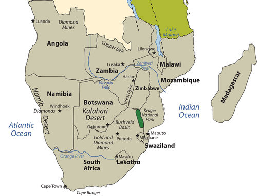 Map of Southern Africa
The region of the African continent south of the Congo and Tanzania is named Southern Africa. The physical location is the large part of Africa to the south of the extensive Congo River basin. Southern Africa is home to a number of river systems; the Zambezi River is the most prominent. The Zambezi flows from the northwest corner of Zambia and western Angola all the way to the Indian Ocean on the coast of Mozambique. Along the way, the Zambezi River flows over the mighty Victoria Falls on the border between Zambia and Zimbabwe. Victoria Falls is the largest waterfall in the world and is a major tourist attraction for the region.
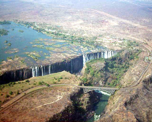 Victoria Falls is a waterfall in southern Africa on the Zambezi River at the border between Zambia and Zimbabwe. It is the largest waterfall in the world.
Southern Africa includes both type B and type C climates. The Tropic of Capricorn runs straight through the middle of the region, indicating that the southern portion is outside of the tropics. The Kalahari Desert, which lies mainly in Botswana, is an extensive desert region with an arid mixture of grasslands and sand. When there is adequate rainfall, the grasslands provide excellent grazing for wildlife. Precipitation varies from three to ten inches per year.
The Kalahari is home to game reserves and national parks. Large areas of dry salt pans stretch over ancient lake beds. The salt pans fill with water after heavy rainfall but are dry the remainder of the year. The Namib Desert, found along the west coast of Namibia, receives little rainfall. Moderate type C climates are found south of the Kalahari Desert in South Africa, where conditions are suitable for a variety of agricultural activities, including fruit orchards and an expanding wine industry.
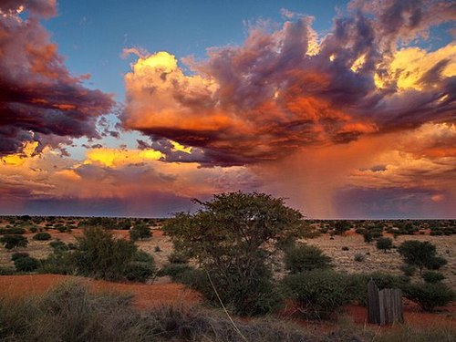 A thunderstorm in the Kalahari Desert near Stampriet, Namibia.
 Madagascar
Madagascar is included in this unit on Southern Africa, but it does not share its cultural geography or biodiversity.
The countries on the Southern African mainland share many of the demographic qualities of the rest of Africa: large family size, agrarian economies, multiple ethnic groups, rural populations, political instability, and a high rate of rural-to urban shift. Southern Africa is set apart from other Sub-Saharan African regions because of its mineral resources, including copper, diamonds, gold, zinc, chromium, platinum, manganese, iron ore, and coal.
Countries in Southern Africa are quite large in physical area, except three smaller landlocked states: Lesotho, Swaziland, and Malawi. The larger countries--South Africa, Botswana, Mozambique, Zimbabwe, Zambia, Namibia, and Angola--all have extensive mineral deposits.
The vast mineral resources make this one of the wealthiest regions of Africa with the greatest potential for economic growth. A physical band of mineral resources in Southern Africa stretches from the rich oil fields off the northwest coast of Angola, east through the diamond-mining region, and into the northern Copper Belt of Zambia. A region of rich mineral deposits continues from the unique geological formation called the Great Dyke in central Zimbabwe through the Bushveld basin into South Africa.
From here, it extends southwest through the central gold- and diamond-mining regions of South Africa toward the southern coast. Mining activity exists on both sides of the belt of mineral resources. Diamond mining is found in parts of Botswana and along the coast of Namibia. Coal can be found in central Mozambique. The countries that are able to conduct the necessary extractive processes are creating national wealth and increasing the standard of living for their people.
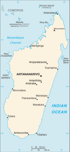 Map of Madagascar
Madagascar is located to the east of the continent, in the Indian Ocean. Madagascar is the world’s fourth-largest island and is similar in area to France. Surrounding Madagascar are the independent island states of the Seychelles, Comoros, and Mauritius. Madagascar is included in this unit on Southern Africa but does not share its cultural geography or biodiversity.
Madagascar broke away from the mainland more than 160 million years ago and developed its own environmental conditions and cultural heritage. The early human inhabitants of Madagascar can trace their ancestry to the regions of Malaysia and Indonesia in Southeast Asia. People from the African mainland also joined the population. The whole island later came under the colonial domination of France but won its independence in 1960.
Madagascar’s unique physical environment is home to many plants and animals found nowhere else in the world. At least 33 varieties of lemurs and many tropical bird species and other organisms are found only on Madagascar. It is an area of high biodiversity and is home to about five percent of all the animals and plants in the world. Tropical rain forests can be found on the eastern edge on the windward side of the island. The western side of the island experiences a rain shadow effect because of the height of the central highlands, which reach as high as 9,435 feet. The western side of the island has a smaller population and receives less precipitation.
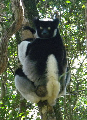 The indri Lemur in Madagascar is known locally as babakoto, which translates to "Ancestor of Man."
 Since 1990, the eastern tropical rain forest has experienced a sharp decline because of extensive logging, slash-and-burn agriculture, mining operations, and drought. Population growth has placed a heavier demand on the environment, which in turn puts stress on the habitats of many of the unusual organisms that are unique to the island. Typical of many African nations, agriculture is Madagascar’s main economic activity. About 80 percent of the 25 million people who live on the island earn their living off the land.
Deforestation is occurring on all parts of the island and is more severe in areas where human habitation leads to a high demand for firewood used in cooking. In other parts of Africa, important environmental areas have been protected or transformed into national parks and wildlife preserves. Though protected areas do exist on Madagascar, efforts to protect the environment and the wildlife have been hampered by the lack of available funding and the population’s high demand for natural resources.
Angola
 Map of Angola
 The largest country in Southern Africa is Angola. Located on the west coast of the continent, the country includes the small exclave of Cabinda to the north, which borders the Congo River and is separated from the main body of Angola. Cabinda is a major oil producer and remains a foothold for rebel groups seeking greater control over oil resources. Offshore oil activity has increased in the northern region of Angola and has attracted international oil companies from many countries.
In 2007, Angola was the largest oil exporter to China, which has become one of Angola’s largest financial supporters. Oil revenues have helped Angola rebuild after a bitter civil war (1975–2002) devastated the country and its infrastructure. Angola is also burdened with thousands of refugees seeking safety from the civil wars in the Congo.
Angola was a Portuguese colony and fought hard for independence, which it received in 1975. After independence, strong factions clashed to obtain political power. At the same time, the Cold War was at a high point. The United States and the Soviet Union both used their influence to support political leadership in Angola and other parts of Africa to reflect their respective ideologies. Even Cuba had a large number of military troops in Angola in support of a socialist agenda.
As the factions within Angola fought for power, the country was deeply divided. Thus began a 27-year civil war that finally ended in 2002. The country has been working to recover from this turmoil ever since. Foreign aid and charitable organizations have helped feed the people, and oil revenues are beginning to support recovery. The government of Angola has suffered from serious corruption. Much of the wealth is centralized in the hands of an elite few and does not filter down to the general population.
Natural resources were a major factor in the long, drawn-out civil war. Angola was one of the original countries in which the term blood diamonds was used. Resistant groups would mine the diamonds, sell them on the world market, and use that income to fund their military pursuits. Revenue from the diamond trade fueled the death and destruction of the newly independent country.
Diamonds are still being mined in Angola and bringing in considerable national income. The industry is not always controlled or managed to lessen the number of diamonds reaching the market from dubious sources. Natural resources have helped the country look to a future in which a more stable government can work to rebuild the country’s infrastructure and improve the standard of living for its people.
Namibia
 Map of Namibia
 Namibia is a dry, arid land with few people. Its population density of about 6.5 people per square mile in 2009 was the second-lowest in the world after Mongolia. The physical geography of this large country is dominated by arid plateaus and desert regions with changes in elevation between them. The Namib Desert, characterized by enormous sand dunes, runs along the entire west coast. It meets up with the Great Escarpment, which is a sharp rise in elevation of as much as a mile high toward the interior. A central plateau dominates the north-south interior, and the Kalahari Desert is to the east.
Natural resources are abundant. Uranium and diamonds are the major export products; lead, zinc, tin, silver, copper, and tungsten are also mined. The coastal waters support a substantial fishing industry. Namibia’s constitution contains language that addresses environmental conservation and the protection of wildlife habitat. The country has created nature conservancies, which have advanced the activities of ecotourism, a source of national wealth promoted by the government.
The Berlin Conference of 1884, when the colonial European powers met to divide up Africa, resulted in the German colonization of the region of Namibia. The German influence remains evident in the dominant religion. Most of the Christians in Namibia, which now make up about 80 percent of the population, are Lutherans.
By 1920, the region known as South West Africa had been transferred to South Africa by the League of Nations. South West Africa had to endure the political policies of apartheid while under the jurisdiction of South Africa. By 1966, local uprisings and a push for sovereignty resulted in a socialist independence movement that created the South West Africa People’s Organization (SWAPO). This organization was entrenched in a guerilla war with South Africa, which led to the return of Namibia to United Nations (UN) supervision. The name Namibia was adopted during this era. Socialist countries such as Cuba provided supported SWAPO’s movement for autonomy.
The 1980s brought about a transition in the governing process in the Namibian War of Independence. In 1985, South Africa installed an interim government in Namibia. A UN peace plan was reached that included Namibia in 1988, and Namibia finally gained its independence in 1990 following South Africa’s withdrawal from Angola in their civil war. SWAPO has become the dominant Namibian political affiliation. As a recently independent country, Namibia has had to work through a natural transition process to create a stable government to sustain itself as an independent country.
Zambia
 Map of Zambia
The landlocked country of Zambia was known as Northern Rhodesia during colonial times. From 1891 to 1923, it was administered by Britain’s South Africa Company. Then it became a colony of Great Britain. The name was changed to Zambia when the country was granted independence in 1964. Lusaka is its primate city and capital.
Mining in the Copper Belt to the north provides both economic activity and employment opportunities for the people, but long distances from major seaports and the fluctuation in world commodity prices do not provide a stable economic situation for the mining industry. Though most of the population makes their living by subsistence agriculture, the country has a large urbanized population that heavily depends on the mining industry for employment and economic support.
The country is expected to double in population in about 35 years if current rates continue. The average family size is more than five members. The larger towns and cities along the major transportation routes are the main population centers. Unemployment remains high in these urban areas, and there are few opportunities for economic development. More than 70 ethnic groups can be found in Zambia, including a small but growing Chinese population. English is the official language, but many other languages are spoken. Most of the people are Christians with a wide variety of denominations. Animist and traditional beliefs are also common.
Malawi
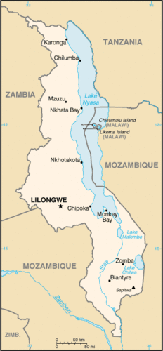 Map of Malawi
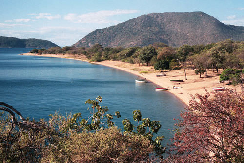
 Malawi is a landlocked nation that became independent in 1964. The British controlled the region in 1891 and named their colony Nyasaland after Lake Nyasa, a large lake in Malawi; the lake is also called Lake Malawi. The lake serves as the eastern border of the country. Another name for Lake Malawi is Calendar Lake, named so because of its physical dimensions, which are 52 miles wide and 365 miles long. Lake Malawi is a deep water lake with depths reaching 2,300 feet. The great depths of the lake are caused by the Great Rift Valley, which created the depression the lake rests in. The lake provides for the livelihoods for millions of people who live along its shores and depend on its resources of fish and fresh water.
 Lake Malawi is an African Great Lake and the southernmost lake in the East African Rift system, located between Malawi, Mozambique and Tanzania.
Malawi is not a technologically developed country. Only about 15 percent of the population lives in urban areas. About 90 percent of the country’s exports are agricultural products of tea, sugar, coffee, and tobacco. Malawi’s government requires substantial assistance from the international community, such as the World Bank and the International Monetary Fund (IMF). Complicating the situation are instances of government corruption that have led to the withholding of international aid. Another major problem for Malawi is the significant number of HIV-infected people. Also, the average family size is large, and rapid population growth places an ever-increasing demand on natural resources.
Mozambique
 Map of Mozambique
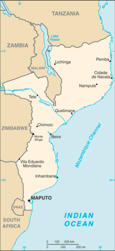
Before colonial Europeans arrived in the region of Mozambique along Africa’s east coast, the Bantu people of a number of ethnic subgroups were the dominant people, and they still make up more than 99 percent of the population. Portugal had claimed the region as a colony as early as the 16th century. Portugal strongly resisted releasing its claims to Mozambique but did so after much opposition. The country became independent in 1975.
The transition from colony to independent nation was a struggle for Mozambique. The rebel groups that had been instrumental in fighting a guerrilla war for independence against Portugal remained active after 1975 and fighting continued after independence. The country fell into a violent civil war from 1977 to 1992. Central elements in this war were involvement or influence by Zimbabwe and South Africa on one side and Marxist support from the Soviet Union on the other.
More than one million people died in this brutal war, which also devastated the country, destroyed valuable infrastructure, and created more than one million refugees who sought sanctuary in neighboring countries. At the same time, most people of Portuguese descent left because of safety concerns. A peace agreement was finally reached in 1992. Since then, the country has struggled to create a stable government and provide a safe environment for its people.
Foreign aid has remained a necessity to provide economic stability for Mozambique. The agrarian society includes a high percentage of the population that lives below the poverty line. Selective mining operations and the introduction of garment manufacturing augments the main agricultural activities. Since 2000, the government has worked to implement economic reforms and to curb excess spending. Both have had a positive effect on economic growth.
It is not unusual for foreign debt to plague developing countries, and Mozambique has suffered from a high level of national debt that has threatened to bankrupt the country. Debt relief for Mozambique came through the International Monetary Fund's debt forgiveness program. Both debt forgiveness and loan rescheduling agreements were implemented. The positive growth pattern indicates that even desperately poor countries can work to improve the standard of living for their people if there are adequate resources and opportunities for employment. Still, rapid population growth potentially cancels out economic gains and threatens to deplete valuable resources, thereby creating an even more difficult path for future stability.
Zimbabwe
 Map of Zimbabwe
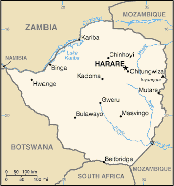
There is no better way to understand Zimbabwe than to become familiar with the history and heritage of the people who live there. The Great Zimbabwe Kingdom flourished from about 1250 to 1450, when it was eclipsed by succeeding kingdoms. Ruins from the extensive stone architecture of that era remain and are a major tourist attraction. These kingdoms were major trading centers for the region but later clashed with the colonial powers that desired to dominate regional trade for themselves. The Bantu civilization of Southern Africa established a number of kingdoms that existed in Zimbabwe up to the colonial era.
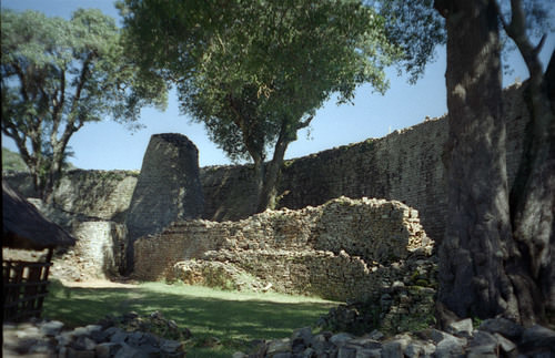 Inside of the Great Enclosure, which is part of the Great Zimbabwe ruins.
 Zimbabwe experienced similar colonial activity to that which befell Zambia, its neighbor to the north. Britain arrived in the late 1800s, and by 1923 they called their newly controlled colony Southern Rhodesia, after Cecil Rhodes, who headed the British South Africa Company, a mercantile company that broke new ground in the region. The British were able to put down any resistance to their activity and consolidated their holdings.
In 1965, the white-dominated leadership of the Rhodesian government unilaterally declared its independence, but Britain did not recognize this action. The United Nations (UN) issued sanctions against the white leadership. The response was an internal guerrilla uprising to fight for free elections that would include black Africans. Independence was finally granted in 1980, and the country’s name was officially changed from Rhodesia to Zimbabwe.
In 1980, Robert Mugabe came to power as the first president and extended his authoritarian rule for 30 years. During this time, the country experienced civil unrest and political turmoil. Mugabe was accused of corruption, election rigging, and pillaging of public funds for personal gain. Under his leadership, there were accusations of government mismanagement, human rights abuses, and hyperinflation of the country’s currency.
In 2008, inflation led to serious devaluation of the currency. The Reserve Bank of Zimbabwe printed banknotes in the denomination of 100 trillion dollars that were only worth a few US dollars in the international exchange. Zimbabwe citizens continue to work through these difficult economic conditions.
Mugabe initiated a land reform policy that would take land owned by people of white European ancestry and redistribute it to people of black African ancestry. During the colonial era, white Europeans, who only made up a small percentage of the population, moved in and took control of most of the agricultural lands. Land reform was a progressive policy and was meant to provide a greater level of equality within the country. However, the disorganized methods used to carry out the plan resulted in violence and the confiscation of farmland with little regard for the rule of law.
Thousands of white farmers and their families left the country. Some were killed when their farms were taken over by force. Mugabe was accused of corruption in making sure his cronies benefited from the land reform without being concerned about the general population. The disruption in the agricultural sector resulted in a drastic reduction in agricultural output. The country shifted from a once sustainable, prosperous agricultural sector with extensive exports to an agricultural system that was in disarray. The result was food shortages and the loss of enormous agricultural export profits.
Shaping a stable post-Mugabe government will be a challenge for Zimbabwe. Solving the problems resulting from the transition from exploitive colonial rule to personal authoritarian rule will be a difficult undertaking. The country has serious economic problems that have lowered the number of opportunities and advantages for its people. Life expectancy has dropped from about 60 years in 1990 to fewer than 40 years two decades later.
Health care, education, and social services have not reached the level needed to sustain a healthy society by world standards. The HIV/AIDS epidemic has hit Zimbabwe hard, affecting a higher percentage of its population than most of the other African countries. Political turmoil, civil unrest, and violence have reduced the level of law and order within the country. These issues are indicators that within the globalization process, countries such as Zimbabwe will be losing out on the opportunity to attract foreign investments, manufacturing expansions, or employment opportunities being developed elsewhere to meet the demands of the marketplace.
Botswana
 Map of Botswana
 The country of Botswana is relatively flat, and the Kalahari Desert covers as much as 70 percent of its land area. By the time it established independence from Britain in 1966, the lack of agricultural lands had reduced the country’s economic level to the lowest in the world. At that time, the country was called Bechuanaland.
Botswana has transitioned more smoothly than other African countries into a stable political system with a fast-growing economy. It has an emerging service sector, extensive diamond mining, and expanding industrial ambitions. Personal incomes are rising, and the standard of living is reaching upward to the second highest in the region after South Africa.
Botswana is fortunate to have had uninterrupted civilian political leadership for the decades following independence. This stable government has implemented progressive social policies and attracted significant capital investments to create one of the most dynamic economies in Africa. Diamond mining has been the principle extraction activity dominating the country’s export income. The stability of the country has enhanced the tourism market and created a growing ecotourism industry. The vast Kalahari Desert and the well-protected game reserves provide attractive tourist destinations.
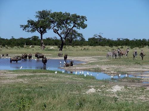 Gnus and Zebras in Chobe National Park, Botswana
Far from the fast-growing urban development of the big cities in Botswana, there exists a dispute between the government of Botswana and the indigenous San people who live in the middle of the Central Kalahari Game Reserve. The government has established programs to move the San from the reserve to other locations where they would become less nomadic and settle into a more agrarian lifestyle.
According to the government position, this is to keep the natural habitat and wildlife from being affected by human activity, thereby promoting tourism. The courts, however, ruled against the forced move of the San out of the Central Kalahari Game Reserve. Critics of the government program claim the real reason for the move is to clear the land of human habitation so the area can be developed for mining purposes. Estimates indicate that fewer than 100,000 San presently live in Southern Africa. About 55,000 San live in Botswana.
Botswana’s government has advanced one of Africa’s most progressive and comprehensive programs for dealing with HIV/AIDS. Medical care, education, and social services are being strengthened. Botswana ranks at the top end in terms of the percentage of people who are infected with HIV/AIDS. This epidemic cuts across all levels of society and culture. The social stigma attached to being infected with HIV discourages individuals from being tested for the disease or seeking medical care. Addressing this epidemic is a challenge throughout Southern Africa.
South Africa
 Map of South Africa
Anchoring Sub-Saharan Africa to the south is the country of South Africa. Its large land area and vast mineral resources support a population of more than 54 million people. The Cape of Good Hope on the southern tip of the continent is a transition point from the Atlantic Ocean to the Indian Ocean. Its strategic location was important for the control of shipping during the early colonial era before the Suez Canal provided a shortcut between Europe and Asia, bypassing most of Africa. The European colonial era first brought Dutch explorers to the Cape of Good Hope, where they established the city of Cape Town as a stopover and resupply outpost on their way to rest of Asia.
South Africa is home to many indigenous ethnic groups and is demonstrative of the diverse pattern of human geography. The country has a history of both ethnic diversity and ethnic division. Two of the largest African groups are the Xhosa and the Zulu. The European component of the ethnic mosaic was enhanced by colonial and neocolonial activities. After the arrival of the first Dutch ships, other Europeans followed and competed with the African groups for land and control.
The discovery of first diamonds and then gold prompted Britain’s involvement in South Africa. The Boer Wars (1880–81 and 1899–1902) were fought between the Dutch-based Boers and Britain for control of South Africa’s mineral resources. South Africa became a British colony dominated by a white power structure. The Boers (later known as Afrikaners) spoke Afrikaans and were prominent in the South African political system.
Segregation first developed as an informal separation of the racial groups but evolved into the legally institutionalized policy of apartheid, which separated people into black, white, and colored (mixed race) racial categories. A fourth category was developed for people from Indian or Asian backgrounds. Apartheid eventually found its way into every aspect of South African culture.
In the larger scale of society, access and separation were based on race. Each racial group had its own beaches, buses, hospitals, schools, universities, and so on. The legal system divided the population according to race, with the white minority receiving every advantage. There were extensive and detailed rules for every aspect of daily activity, including which public restroom or drinking fountain could be used, which color an individual’s telephone could be, and which park bench a person could sit on.
The government also sanctioned separate homelands for people from different ethnic groups. People were physically removed from their homes and transported to their respective new homelands based on their racial or ethnic background. The policy of apartheid not only divided the country at that time but set up racial barriers that will take generations to overcome.
The controversial policy of apartheid in South Africa achieved international attention. Many countries condemned it and implemented economic sanctions and trade restrictions against South Africa. Opposition grew within the country and erupted into violence and social unrest. As a result, the white-dominated government of South Africa began to dismantle the apartheid system in the 1990s.
The ban on political opposition parties, such as the African National Congress, was lifted, and after 27 years in prison, Nelson Mandela was released from prison, where he had held for his resistance activities. The apartheid legislation was repealed, and a new era began. Mandela was the first African to be elected president of South Africa in the new multiracial elections of 1994. His presidency, which ended in 1999, set the stage for a multiracial society. South Africa is still working through the consequences from years of racial separation.
South Africa has large, modern cities such as Cape Town, Johannesburg, and Durban, each about the size of the US city of Chicago or larger. The cities of Pretoria, East Rand, and Port Elizabeth are also major metropolitan areas and have more than one million people each. These urban centers all contribute to and support the extensive mining and agricultural activities that provide national wealth. As the country that exports more diamonds than any other in the world, South Africa has gained much national income from the extraction of mineral resources, which are being tapped by some of the largest mining operations on Earth.
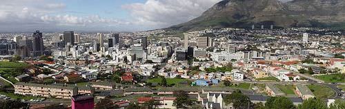 Cape Town is a coastal city in South Africa. It is the second most populous urban area in South Africa after Johannesburg.
Large parts of South Africa have a moderate climate and good soils, which combine to produce enormous quantities of agricultural products, both for domestic consumption and for export profits. Mining and agriculture have provided extensive opportunities for employment. These opportunities draw in migrants from neighboring countries that have experienced either political unrest or poor economic conditions. These immigrants add to the cultural dynamics of an already ethnically diverse country.
South Africa’s manufacturing sector is not well developed. The country depends on Europe, East Asia, and the United States, the three main core economic areas of the world, to provide postindustrial goods. There are few well-paying manufacturing jobs to provide for a growing or stable South African middle class.
The structure and dynamics of the current economic activities have brought about a two-tiered socioeconomic system. Most of the population may work in the mines, in agricultural activities, or in the service sector, but they are not directly benefiting from the profits of their labor, other than earning a wage. These people find themselves in the poorer working-class majority of the population.
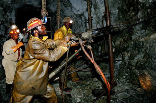 Gold miners in South Africa must endure difficult working conditions.
 The landowners, mining corporation executives, and social elite that control the service sector or are employed in activities such as banking or the commodity markets are receiving higher incomes and have created a wealthier upper class. Apartheid supported this class division. The current free and open legal system has yet to bring about a change in the socioeconomic structure of the population. Millions of poor ethnic minorities find themselves in living conditions similar to their economically depressed neighbors in other parts of Africa, while the wealthier upper class has established a good standard of living similar to that of the core economic areas of the world.
South Africa redrew its internal provincial boundaries in 1994. The large former Cape Province in the south, which had been a former British center of power, was divided into three smaller provinces. The large Transvaal Province in the north, which had been a center for Afrikaners, was divided into four smaller provinces. Orange Free State changed its name to Free State and Natal Province changed its name to KwaZulu-Natal. The changes were made based on the size and political management of the country that had come with the transfer of power when Mandela became president. The European colonial pattern of settlement was adjusted to represent a more South African pattern of political administration.
The 2010 World Cup Soccer Games
In 2010, South Africa was chosen to host the World Cup soccer games. The African teams included Algeria, Cameroon, Ivory Coast, Ghana, Nigeria, and South Africa. The World Cup is held once every four years. The cost to host the games was enormous and also a testimony to the people and government of South Africa. The country had to build five new stadiums and upgrade five existing stadiums for the games. The largest stadium was Soccer City in Johannesburg, with a capacity of about 84,490. Overall construction costs were estimated to be more than one billion dollars. Transportation infrastructure and road networks were also improved.
The preparations and costs that South Africa undertook to hold the games were not without controversy. Sections of shack dwellers in Durban and in other places were relocated to be out of the sight of international visitors attending the games. This move was made to improve the country’s image for tourism. There were also reports of strikes by the construction workers building the stadiums, many of them temporary workers making about 300 dollars per month, who argued that their wages were too low.
South Africa’s unemployment rate at the time was about 25 percent, and the country continues to struggle with unemployment. The hope was that the infrastructure improvements would benefit the country for the long term and that tourism would increase if the individuals who came for the games encouraged others to visit. South Africa was banking on this event to boost its economic conditions and strengthen its standing in the global marketplace.
The impact of sports on society—both positive and negative—can be enormous. Hosting the World Cup necessitated the strengthening of South Africa’s security operations to meet FIFA (Fédération Internationale de Football Association) standards to handle the high influx of participants and visitors. It has been estimated that South Africa invested about $4.3 billion to host the games. These are billions of dollars that did not go toward providing water, medical clinics, and educational support to the poorest neighborhoods and communities. The financial investments indicate the power and attraction that the World Cup holds on a global basis. No African team was in the final match, but soccer is a widely supported sport throughout Africa.
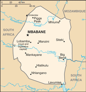
Swaziland and Lesotho
 Map of Swaziland
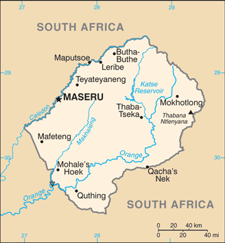 Map of Lesotho
 The two small landlocked enclaves of Swaziland and Lesotho are independent countries surrounded by South Africa. Mozambique borders Swaziland to the north. Under British occupation, the area of Lesotho was called Basutoland. Upon achieving independence in 1966, the area was renamed the Kingdom of Lesotho. The country is mountainous, and most of the land area is more than one mile in elevation.
The Sotho people have a Bantu background and speak a Bantu language. More than 80 percent are Christian. Lesotho is the size of the US state of Maryland and has a population of approximately two million people. The main economic activity has been based on agriculture, but a large percentage of income comes from remittances from Lesotho citizens who work in South Africa. Light manufacturing is beginning to emerge to improve the economy.
Lesotho is a constitutional monarchy, which means the government is led by a prime minister, but the king retains his ceremonial position. Reforming the country from a kingdom to a democratic-style government has not been without obstacles. The country has been subjected to political unrest, resulting in many years of military rule and violent internal conflicts. Lesotho is trying to stabilize its political situation and economy.
The Swazi Kingdom functioned under relative autonomy during colonial times, and Britain granted independence to Swaziland in 1968. The Swazi are a Bantu people who migrated into Southern Africa centuries ago with the Xhosas and Zulus. Swaziland has low mountains to the north with the grasslands and scrub forests of the savannas in the east and rain forests in the west. It is ruled by an absolute monarch, one of the last in the world. Political unrest has led to challenges to his rule. Reformers are pushing for modification of the government and for some element of democratic reform, but reforms are slow in materializing. The small country of Swaziland is about the size of the US state of New Jersey. There are more than one million people, and one-third of the population is infected with HIV/AIDS.
- Southern Africa is located along the Tropic of Capricorn and is host to various climate zones, including tropical, desert, and moderate type C climates. Extensive agricultural activity can be found south of the Tropic of Capricorn, where moderate climates prevail.
- Madagascar is separated from the mainland of Africa and provides a habitat for animals not found on the mainland. The mainland region is large with many different physical landscapes.
- The mainland region of Southern Africa has extensive mineral deposits that provide resources for its countries to gain national wealth. Approaches to translating mineral deposits into wealth have varied among the countries.
- Many ethnic groups can be found in Southern Africa, ranging from the San in the Kalahari to the Zulu groups to the south. Colonialism made its footprint on the region by creating borders and providing colonial names. The transition from a colony to an independent nation has caused political and economic difficulties.
- South Africa had an apartheid system in place stemming from the colonial era. The apartheid system was dismantled after the 1994 election of President Nelson Mandela. South Africa went so far as to change its provincial system from four to nine provinces to more appropriately politically administer the country.
Vocabulary Terms
|
A political group that was founded in 1912 to unite African people and was opposed to apartheid |
|
|
A policy of complete separation of the races, instituted by the white minority government of South Africa in 1948 |
|
|
Conflict between Dutch and British settlers for control of South Africa |
|
|
A steep slope with a nearly flat top |
|
|
A city established in what is now Zimbabwe by the Shona around 1000 it became the capital of a thriving gold trade in Southern Africa |
|
|
A state founded in the 15th century by a man named Mutota and that extended throughout all of present-day Zimbabwe |
|
|
One of the leaders of the African National Congress who led a struggle to end apartheid and was elected president in 1994 in the first all-race election in South Africa |
|
|
The banning of trade to isolate a country; economic and political penalties used by other countries on South Africa to end apartheid |
|
|
One of the largest indigenous tribal groups in South Africa |
Applying Knowledge
Discussion and Study Questions
- What is threatening Madagascar’s biodiversity?
- What do the Great Dyke and the Bushveld basin offer for economic development?
- What did Namibia do to address environmental conservation and protect its wildlife?
- Name the country that provided support for SWAPO. Why do you think they did so?
- Why is Lake Malawi called Calendar Lake? What process created Lake Malawi?
- How did the Cold War influence Southern African countries?
- What economic condition plagues most developing countries that seek aid from the IMF and the World Bank?
- Why has Botswana reached a higher standard of living for its people than other countries in Southern Africa?
- How has the policy of apartheid affected South Africa? When did apartheid officially end?
- How do the people of Swaziland or Lesotho fit into the two-tiered system of social stratification in South Africa?
Real-World Geography Exercise
- Using Google Maps, complete the following activities:
- Locate each place on the bulleted list below.
- Find the nearest city with an international airport in proximity to each location on the bulleted list below.
- Calculate the distance and travel time by plane to each city from the Seattle-Tacoma International Airport.
- Using NASA Latitude and Longitude Finder, determine the latitude and longitude for each location on the bulleted list below.
- Be prepared to share and discuss your answers.
- Bushveld basin
- Cabinda
- Cape of Good Hope
- Copper Belt
- Great Dyke
- Great Escarpment
- Kalahari Desert
- Lake Malawi
- Namib Desert
- Victoria Falls
- Zambezi River
Current Events
Tablet PCs Preserve Indigenous knowledge
Nine Reasons to Visit the Okavango Delta in Botswana
Zimbabwe Poised for Significant Power Boost as China Rachets Up Investment
Videos for Geography Enrichment
Helpful Websites for the Study of Geography
Canadian Encyclopedia is an encyclopedia funded by the Canadian government covering all branches of knowledge. Their scholarly collection includes interactive materials.
CIA World Factbook provides information on the people, history, government, economy, energy, geography, communications, transportation, military, and transnational issues for the world's entities.
Congress.gov is a US government website where you can find federal legislation, past and present, as well as information about the US legal system.
Drug Enforcement Administration (DEA) is a government agency website that provides current news, resources, topics of interest, information about drugs, careers in the DEA, and a tip hotline.
Library of Congress is the largest library in the world and provides manuscripts, files, information, pictures, and videos.
NASA Earth Observatory (NEO) is a US government agency website that allows users to search for and retrieve satellite images of Earth.
National Archives is a US government website that provides historical documents, photos, records, publications, and educator resources.
National Oceanic and Atmospheric Association (NOAA) is a US government agency website that provides weather-related information and ocean research.
National Map is a website by the United States Geological Survey and other federal, state, and local agencies that delivers topographic information for the United States.
NationMaster is a massive central data source and a handy way to graphically compare nations.
Real-Time World Air Quality Index is a website that measures most locations in the world for air pollution in real time.
StateMaster is a unique statistical database, which allows you to research and compare a multitude of different data on US states.
United Nations (UN) is an international organization founded in 1945 and made up of 193 member states. The UN maintains international peace and security, protects human rights, delivers humanitarian aid, promotes sustainable development, and upholds international law.
United States Census Bureau is a US government agency that provides a population clock, data, surveys, statistics, a library with information and infographics, news about the economy, and much more.
United States Geological Survey (USGS) is a US government agency website that provides scientific information about the natural hazards that threaten lives, the natural resources we rely on, the health of our ecosystems and environment, and the impacts of climate and land-use change.
Whitehouse.gov is a US government website that provides the latest presidential news, information about the budget, policy, defense, and many more topics.
World Health Organization (WHO) is under the United Nations and provides leadership on matters critical to health, shapes the research agenda on health, and monitors the health situation and assessing health trends around the world. Their website provides information on the state of health around the world, outbreaks, current health news, and more.
World Trade Organization (WTO) is an intergovernmental organization that regulates international trade. The website provides information on the history of the multilateral trading system, featured videos, news and events, trade topics, and more.