
10.6: Islands of Southeast Asia (1 Day)
- Page ID
- 1980
\( \newcommand{\vecs}[1]{\overset { \scriptstyle \rightharpoonup} {\mathbf{#1}} } \)
\( \newcommand{\vecd}[1]{\overset{-\!-\!\rightharpoonup}{\vphantom{a}\smash {#1}}} \)
\( \newcommand{\dsum}{\displaystyle\sum\limits} \)
\( \newcommand{\dint}{\displaystyle\int\limits} \)
\( \newcommand{\dlim}{\displaystyle\lim\limits} \)
\( \newcommand{\id}{\mathrm{id}}\) \( \newcommand{\Span}{\mathrm{span}}\)
( \newcommand{\kernel}{\mathrm{null}\,}\) \( \newcommand{\range}{\mathrm{range}\,}\)
\( \newcommand{\RealPart}{\mathrm{Re}}\) \( \newcommand{\ImaginaryPart}{\mathrm{Im}}\)
\( \newcommand{\Argument}{\mathrm{Arg}}\) \( \newcommand{\norm}[1]{\| #1 \|}\)
\( \newcommand{\inner}[2]{\langle #1, #2 \rangle}\)
\( \newcommand{\Span}{\mathrm{span}}\)
\( \newcommand{\id}{\mathrm{id}}\)
\( \newcommand{\Span}{\mathrm{span}}\)
\( \newcommand{\kernel}{\mathrm{null}\,}\)
\( \newcommand{\range}{\mathrm{range}\,}\)
\( \newcommand{\RealPart}{\mathrm{Re}}\)
\( \newcommand{\ImaginaryPart}{\mathrm{Im}}\)
\( \newcommand{\Argument}{\mathrm{Arg}}\)
\( \newcommand{\norm}[1]{\| #1 \|}\)
\( \newcommand{\inner}[2]{\langle #1, #2 \rangle}\)
\( \newcommand{\Span}{\mathrm{span}}\) \( \newcommand{\AA}{\unicode[.8,0]{x212B}}\)
\( \newcommand{\vectorA}[1]{\vec{#1}} % arrow\)
\( \newcommand{\vectorAt}[1]{\vec{\text{#1}}} % arrow\)
\( \newcommand{\vectorB}[1]{\overset { \scriptstyle \rightharpoonup} {\mathbf{#1}} } \)
\( \newcommand{\vectorC}[1]{\textbf{#1}} \)
\( \newcommand{\vectorD}[1]{\overrightarrow{#1}} \)
\( \newcommand{\vectorDt}[1]{\overrightarrow{\text{#1}}} \)
\( \newcommand{\vectE}[1]{\overset{-\!-\!\rightharpoonup}{\vphantom{a}\smash{\mathbf {#1}}}} \)
\( \newcommand{\vecs}[1]{\overset { \scriptstyle \rightharpoonup} {\mathbf{#1}} } \)
\(\newcommand{\longvect}{\overrightarrow}\)
\( \newcommand{\vecd}[1]{\overset{-\!-\!\rightharpoonup}{\vphantom{a}\smash {#1}}} \)
\(\newcommand{\avec}{\mathbf a}\) \(\newcommand{\bvec}{\mathbf b}\) \(\newcommand{\cvec}{\mathbf c}\) \(\newcommand{\dvec}{\mathbf d}\) \(\newcommand{\dtil}{\widetilde{\mathbf d}}\) \(\newcommand{\evec}{\mathbf e}\) \(\newcommand{\fvec}{\mathbf f}\) \(\newcommand{\nvec}{\mathbf n}\) \(\newcommand{\pvec}{\mathbf p}\) \(\newcommand{\qvec}{\mathbf q}\) \(\newcommand{\svec}{\mathbf s}\) \(\newcommand{\tvec}{\mathbf t}\) \(\newcommand{\uvec}{\mathbf u}\) \(\newcommand{\vvec}{\mathbf v}\) \(\newcommand{\wvec}{\mathbf w}\) \(\newcommand{\xvec}{\mathbf x}\) \(\newcommand{\yvec}{\mathbf y}\) \(\newcommand{\zvec}{\mathbf z}\) \(\newcommand{\rvec}{\mathbf r}\) \(\newcommand{\mvec}{\mathbf m}\) \(\newcommand{\zerovec}{\mathbf 0}\) \(\newcommand{\onevec}{\mathbf 1}\) \(\newcommand{\real}{\mathbb R}\) \(\newcommand{\twovec}[2]{\left[\begin{array}{r}#1 \\ #2 \end{array}\right]}\) \(\newcommand{\ctwovec}[2]{\left[\begin{array}{c}#1 \\ #2 \end{array}\right]}\) \(\newcommand{\threevec}[3]{\left[\begin{array}{r}#1 \\ #2 \\ #3 \end{array}\right]}\) \(\newcommand{\cthreevec}[3]{\left[\begin{array}{c}#1 \\ #2 \\ #3 \end{array}\right]}\) \(\newcommand{\fourvec}[4]{\left[\begin{array}{r}#1 \\ #2 \\ #3 \\ #4 \end{array}\right]}\) \(\newcommand{\cfourvec}[4]{\left[\begin{array}{c}#1 \\ #2 \\ #3 \\ #4 \end{array}\right]}\) \(\newcommand{\fivevec}[5]{\left[\begin{array}{r}#1 \\ #2 \\ #3 \\ #4 \\ #5 \\ \end{array}\right]}\) \(\newcommand{\cfivevec}[5]{\left[\begin{array}{c}#1 \\ #2 \\ #3 \\ #4 \\ #5 \\ \end{array}\right]}\) \(\newcommand{\mattwo}[4]{\left[\begin{array}{rr}#1 \amp #2 \\ #3 \amp #4 \\ \end{array}\right]}\) \(\newcommand{\laspan}[1]{\text{Span}\{#1\}}\) \(\newcommand{\bcal}{\cal B}\) \(\newcommand{\ccal}{\cal C}\) \(\newcommand{\scal}{\cal S}\) \(\newcommand{\wcal}{\cal W}\) \(\newcommand{\ecal}{\cal E}\) \(\newcommand{\coords}[2]{\left\{#1\right\}_{#2}}\) \(\newcommand{\gray}[1]{\color{gray}{#1}}\) \(\newcommand{\lgray}[1]{\color{lightgray}{#1}}\) \(\newcommand{\rank}{\operatorname{rank}}\) \(\newcommand{\row}{\text{Row}}\) \(\newcommand{\col}{\text{Col}}\) \(\renewcommand{\row}{\text{Row}}\) \(\newcommand{\nul}{\text{Nul}}\) \(\newcommand{\var}{\text{Var}}\) \(\newcommand{\corr}{\text{corr}}\) \(\newcommand{\len}[1]{\left|#1\right|}\) \(\newcommand{\bbar}{\overline{\bvec}}\) \(\newcommand{\bhat}{\widehat{\bvec}}\) \(\newcommand{\bperp}{\bvec^\perp}\) \(\newcommand{\xhat}{\widehat{\xvec}}\) \(\newcommand{\vhat}{\widehat{\vvec}}\) \(\newcommand{\uhat}{\widehat{\uvec}}\) \(\newcommand{\what}{\widehat{\wvec}}\) \(\newcommand{\Sighat}{\widehat{\Sigma}}\) \(\newcommand{\lt}{<}\) \(\newcommand{\gt}{>}\) \(\newcommand{\amp}{&}\) \(\definecolor{fillinmathshade}{gray}{0.9}\)- Summarize the economic development of each of the countries in this section.
- Understand that Malaysia is divided between the Malay Peninsula and the island of Borneo.
- Outline how the structured island nation of Singapore became an economic tiger.
- Describe the physical geography of Indonesia and the population dynamics of the island of Java.
- Summarize the cultural characteristics of the Philippines.
- Learn why the Philippines is a popular destination for business process outsourcing (BPO).
TEKS Regional Unit 10 East and Southeast Asia: Chapter 10.6 Islands of Southeast Asia
WG.7D Construct and analyze population pyramids and use other data, graphics, and maps to describe the population characteristics of different societies and to predict future population trends.
WG.9A Identify physical and/or human factors such as climate, vegetation, language, trade networks, political units, river systems, and religion that constitute a region.
WG.10D Compare global trade patterns over time and examine the implications of globalization, including outsourcing and free trade zones.
WG.11C Assess how changes in climate, resources, and infrastructure (technology, transportation, and communication) affect the location and patterns of economic activities.
WG.12C Analyze how the creation, distribution, and management of key natural resources affects the location and patterns of movement of products, money, and people.
WG.14A Analyze current events to infer the physical and human processes that lead to the formation of boundaries and other political divisions.
WG.16C Describe distinctive cultural patterns and landscapes associated with...regions of the world and how these patterns influenced the processes of innovation and diffusion.
WG.17C Describe and compare patterns of culture such as language, religion, land use, education, and customs that make specific regions of the world distinctive. make specific regions of the world distinctive.
WG.17B Describe major world religions, including animism, Buddhism,...Hinduism, Islam,... and their spatial distribution.
WG.18B Assess causes, effects, and perceptions of conflicts between groups of people, including modern genocides and terrorism.
WG.18C Identify examples of cultures that maintain traditional ways, including traditional economies.
WG.21B Locate places of contemporary geopolitical significance on a map.
WG.22B Generate summaries, generalizations, and thesis statements supported by evidence.
WG.22C Use geographic terminology correctly.
WG.22D Use standard grammar, spelling, sentence structure, and punctuation.
Islands of Southeast Asia
The islands of Southeast Asia includes the countries of Malaysia, Singapore, Brunei, East Timor, Indonesia, and the Philippines. Of the Southeast Asian countries, East Timor most recently gained its independence. There are major differences in cultural, economic, and political dynamics, and in the ethnic groups that make up the dominant majorities in each. There is also a high level of linguistic and religious diversity.
The physical geography varies from island to island. Some have high mountain relief and others are low-lying and relatively flat. Active tectonic plate action in the region causes earthquakes and volcanic activity, resulting in the destruction of infrastructure and loss of life. Earthquakes and volcanic activity greatly impacted human life on the islands.
Economic forces continue to prompt the countries of Southeast Asia to enter into trade relationships that integrate them with global networks based on dependency and reliance. The old colonial powers may no longer control them politically but may impact them economically. The new dynamics of corporate colonialism, with their economic power located in the core economic regions, still seek to exploit the countries of Southeast Asia for their labor and resources.
These Asian nations are working to develop their own economies and use their own labor and resources to gain national wealth and increase the standard of living for their people. Each country has to contend with globalization forces within the international network of economic relationships.
Malaysia
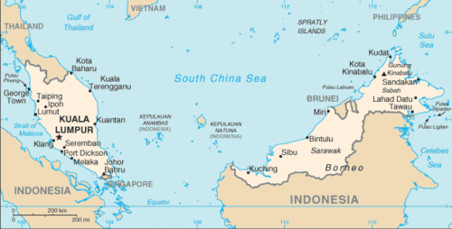 Map of Malaysia
 Malaysia is a country made up of various British colonies that came together as a federation and then became an independent country. Britain started establishing colonies in the region in the late 1700s. The two main areas include the western colonies on the Malay Peninsula and the eastern colonies on the island of Borneo. The western settlements were part of the Malay Peninsula, which included the colonies of Pinang and Singapore.
Eventually, the British took control of the eastern colonies of Brunei, Sarawak, and Sabah on the island of Borneo. In 1957, the western colonies on the mainland peninsula broke from their British colonizers and became an independent country called the Federation of Malaya. In 1963, the British Borneo colonies of Sarawak and Sabah joined the Federation of Malaya to form the current country, which is called Malaysia. In 1965, Singapore broke off from Malaysia and became an independent country. Brunei, which was still a British protectorate, became independent in 1984.
Malaysia has two mainland areas separated by the South China Sea. The regions of Sarawak and Sabah, on the island of Borneo, are called East Malaysia. The mainland on the Malay Peninsula is called West Malaysia. These regions have similar physical landscapes, which include coastal plains with nearby densely forested foothills and mountains. The highest mountains, rising 13,436 feet, are in East Malaysia on the island of Borneo. Located near the equator, Malaysia has a tropical Type A climate with monsoons regularly occurring from October to February.
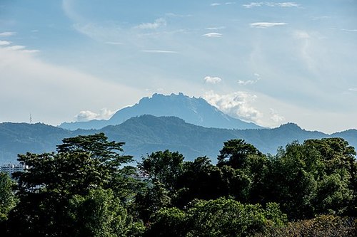 Mount Kinabalu is a mountain in Sabah, Malaysia.
Diversity of Culture and Ethnicity in Malaysia
Malaysia’s culture is diverse in that several major religions are practiced within its borders. Islam is considered the official religion and is supported by at least 61.3 percent of the population. About 19.8 percent of the people are Buddhists, 9.2 percent Christians, and 6.3 percent Hindu. The remaining percentages of the population include traditional Chinese religions and local tribal beliefs.
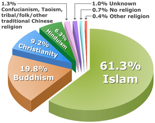 The percentage distribution of Malaysian population by a religion based on 2010 census.
 In this Islamic country, there are concerns that Muslims get preferential treatment by government programs and policies. There are even special judicial legal courts for Muslims only to work out issues regarding marriage, custody, inheritance, or other conflicting Islamic issues regarding faith and obligation. This court only hears Islamic issues and no other legal matters.
There have been movements by minority extremist groups that would like to see Malaysia shift toward a true Islamic state, complete with the Sharia Criminal Code as the law of the land. The movement, however, has been put down by the government. Since 9/11 in the United States, there has been more concern about extremist religious views in Malaysia.
People of Malay ethnic background, also called Bumiputera, make up approximately 67.4 percent of the population. People of Chinese descent are the second-largest group at about 24.6 percent. An additional 7.3 percent of the population is made up of indigenous groups. During British colonialism, a number of people from South Asia were brought to Malaysia. For example, Tamils were brought from India to work the plantations. Their Hindu beliefs were infused into the culture. Some Tamils also converted to Christianity. Sikhs were brought from South Asia to help Britain run the country as police, soldiers, or security officers. The Sikhs who came brought their religion with them, which added to the multi-religious dynamics of the country.
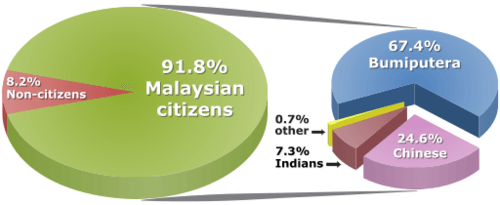 The percentage distribution of Malaysian population by ethnic group based on the 2010 census.
 Malaysia’s diverse ethnic and cultural mix often results in strong centrifugal forces that push and pull on the societal dynamics of the country. China has been active in the business community and has established strong economic ties with regional countries that have Chinese populations. The single largest minority group in the province of Sarawak on Borneo is Chinese.
As a minority group, Chinese citizens of Malaysia have felt discrimination. Since the official language is Malay and the official religion is Islam, there have been concerns about discrimination against all minority groups. Working through the cultural and ethnic diversity has been a major challenge for the country. Each minority religious or ethnic group desires to celebrate its own special holidays.
For example, there is the usual New Year’s celebration on January 1, and then there is the traditional 15-day Chinese New Year celebration celebrated at a different time of the year. Sikhs celebrate the Sikh New Year. Buddhists celebrate a holiday in honor of the life and enlightenment of Buddha. Christians celebrate Christmas and Easter. Many other holidays of significance are respected or honored by various minority groups.
Economic Development in Malaysia
Malaysia has rapidly advanced its economy in recent decades and is modernizing its infrastructure—roads, bridges, highways, and urban facilities. In the capital city, Kuala Lumpur, Malaysia built a modern central business district (CBD) with a twin high-rise office building claimed to be the world’s tallest at the time of construction. Before the global economic downturn that started in 2007, Malaysia had developed a fast-growing economy and was industrializing at a rapid rate.
Malaysia has taken advantage of its location on a major shipping lane and has shifted to manufacturing as an important sector of its economy. The country has been a leader in the export of natural resources such as tin, rubber, and palm oil, and has developed its agricultural and extractive sectors to gain income. The 1980s and 1990s were prosperous times for the country and it matured its manufacturing base from light textiles into electronics and heavy industries.
One aspect of the country that is looming on the horizon and may cause problems is the high population growth rate. In 2017, Malaysia’s population was estimated at more than 31 million, with a doubling time of about 40 years. Though the country is 70 percent urban, family size (fertility rate) is 2.1, which indicates an increasing population growth pattern. One-third of the population is under the age of 15.
Malaysia is one case where the general principle is that if a country urbanizes and industrializes the family size will go down has not taken place fast enough. The fertility rate has dropped from 5.0 to 2.1, but it needs to get below a rate of about 2.0 if the country is going to successfully stabilize its population growth. Unless the country addresses this population growth, the demand for resources might outstrip economic progress in the future.
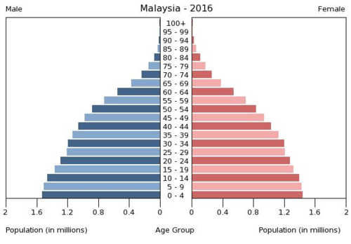 Age structure of Malaysia: 0-14 years: 27.83% (male 4,493,084/female 4,238,991); 15-24 years: 16.81 percent (male 2,677,834/female 2,598,958); 25-54 years: 41 percent (male 6,507,499/female 6,358,762); 55-64 years: 8.27% (male 1,316,331/female 1,277,558); 65 years and over: 6.1 percent (male 907,850/female 1,005,125)
Singapore
 Map of Singapore
 Singapore, which is located between Malaysia and Indonesia, has a population of almost 6 billion people, according to the CIA World Factbook 2017 estimate. Most of the population is located along the southern coast with a few dense clusters located in the central areas. English and Mandarin are the most common languages spoken in Singapore, but other languages include Malay, Tamil, and several Chinese dialects. Buddhism is the most prominent religion practiced in Singapore, followed by Christianity and then by people who do not adhere to any religion.
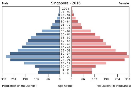 Age structure of Singapore: 0-14 years: 12.82% (male 386,139/female 368,874); 15-24 years: 16.56 percent (male 479,683/female 495,649); 25-54 years: 50.53 percent (male 1,448,463/female 1,527,038); 55-64 years: 10.46% (male 308,477/female 307,557); 65 years and over: 9.63 percent (male 258,597/female 308,449)
| Language used most frequently at home | ||
|---|---|---|
| Language | Percent | |
| English | 36.9% | |
| Mandarin | 34.9% | |
| Malay | 10.7% | |
| Tamil | 3.3% | |
| Others | 14.2% |
| Religion in Singapore, 2015 | ||
|---|---|---|
| Religion | Percent | |
| Buddhism | 33.2% | |
| Christianity | 18.8% | |
| No religion | 18.5% | |
| Islam | 14.0% | |
| Taoism and folk religion | 10.0% | |
| Hinduism | 5.0% | |
| Other religions | 0.6% |
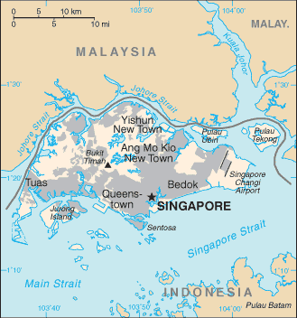
Under British colonial rule, the island of Singapore was included in the Malaysian federation. It broke away and became independent in 1965. It is a small island measuring about 30 miles long at its widest point. Singapore is about 240 square miles in area. Its most valuable resource is its relative location, and it is similar to Hong Kong in its development. With a good port, Singapore is a hub for ships sailing between Europe and China. It serves Southeast Asia as anentrepôt, or break-of-bulk point, where goods are offloaded from large ships and transported to smaller vessels for distribution to the Southeast Asian community.
Singapore has made good strategic utilization of its geographic location by serving as a distribution center for goods and materials processed in the region. Crude oil from Indonesia is unloaded and refined here. Raw materials are shipped in, manufactured into finished products, and then shipped out to global markets. Since Singapore is small, it has had to concentrate on manufacturing goods that provide for optimal profits. As an economic tiger, Singapore has transitioned through the same stages as Taiwan, South Korea, and Hong Kong to become an economic power in Southeast Asia.
To keep labor costs low, initial manufactured products were textiles, clothing, and cheap goods. As incomes and labor skills rose, so did the complexity of the manufactured goods. The government of Singapore has targeted certain types of products to ensure a high-profit margin and a global market need. This has included automation equipment, biotechnology, and high-end information technologies.
Singapore does not manufacture automobiles but it does manufacture automation robotic components that most modern auto manufacturers will purchase and use. Medical technology is expensive and is in high demand the world over. Singapore is targeting this market. The information age has spawned new technologies that are evolving rapidly and, once again, Singapore has been at the center of this industry. Singapore has been a center for the production of computer disc drives for a multitude of global corporations.
Singapore Island is a swampy place with no natural resources. All production components, food goods, construction materials, and energy must be imported. Importing everything has raised the cost of living. To compete with the other Asian economic tigers in the global marketplace, Singapore has implemented severe control measures on its operations. There are harsh penalties for criminal activities and for even misdemeanor offenses. Singapore is a safe place to live because of its strict state rules. It has an authoritarian government, which strives to create an attractive place for international corporations to operate. One of the objectives is to eliminate corruption and establish a business-friendly environment.
The government of Singapore has entered into trade agreements with two of its neighbors to provide raw materials and cheap labor. A trade triangle has been established with Singapore, Malaysia, and Indonesia. Malaysia and Indonesia provide Singapore with raw materials and cheap labor; Singapore provides its neighbors with technical know-how and financial support. This arrangement is beneficial to all three countries.
Singapore is an excellent example of the upper end of the economic spectrum in Southeast Asia. Singapore is already 100 percent urban with high incomes based on high-tech manufacturing and processing of raw materials. Singapore is an economic hub for Southeast Asia, complete with global airline connections and is located on a major shipping lane. Singapore’s world-class port is one of the busiest in Asia.
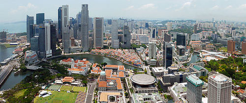 Singapore's central business district is the core financial and commercial hub.
Indonesia
 Map of Indonesia
 The country of Indonesia is the world’s largest archipelago state, consisting of more than 17,500 islands, about one-third of which are inhabited. Indonesia is the sixteenth-largest country in the world by area. The combined area of all the islands and regions of Indonesia would equal the size of the country of Mexico. The country shares land borders with the Borneo side of Malaysia, the western half of the island of Timor, and the western portion of the island of New Guinea, which is shared with the country of Papua New Guinea.
The country’s location on both sides of the equator provides a tropical Type A climate, complete with a monsoon season. Average rainfall can vary from 70 to 240 inches per year. The highest mountain is in West Papua and rises to about 16,024 feet. Indonesia is located on the Pacific Rim, where tectonic plate activity produces earthquakes and volcanic activity.
The country is home to over one hundred 50 active volcanoes, including two of the most famous ones, Krakatoa and Tambora. Both had devastating eruptions in the past two centuries. One of the most violent volcanic explosions ever recorded in human history came from Krakatoa, which is located between the islands of Java and Sumatra.
A series of eruptions in 1883 was heard as far away as the coast of Africa. Shockwaves reverberated around the globe seven times. Ash erupted into the atmosphere to a height of about 50 miles. The official death toll was 36,417, but estimates from local sources place it as high as 120,000. Global temperatures fell by about two degrees Fahrenheit, and weather patterns were disrupted for the next five years. Krakatoa remains active. Over the past few decades, the volcanic peak has been growing at the average rate of about five inches per week.
The tropical climate and the archipelago nature of the country provide for enormous biodiversity within the environment. Second only to Brazil in its biodiversity, Indonesia is home to an enormous number of unique plants and animals. The habitats of many of these creatures are being encroached upon by human activity. The remote islands have more of a chance of escaping habitat devastation and remaining intact, but agricultural and extractive economic activities have converted much of the natural environment into a cultural landscape that is not conducive to environmental sustainability.
Animals such as orangutans are losing their natural forests and may become extinct if current trends continue. The timber industry has brought about deforestation. Slash and burn agriculture has destroyed forest habitat, and human development patterns such as roads and urbanization have altered the ecosystems of the region. According to recent reports, Indonesia is one of the largest emitters of carbon dioxide in the world because of the high number of forest fires set each year.
In 2009, the United States brokered a deal with Indonesia to forgive 30 million dollars of its debt if the country would work to protect forests on the island of Sumatra, which is home to endangered indigenous animals such as tigers, elephants, rhinos, and orangutans.
In 2017, the population of Indonesia was more than 260 million people . Indonesia has the fourth-largest population of any country in the world, after the United States, India, and China. Indonesia also has more Muslims than any other country in the world. More than one-half of the population of Indonesia lives on Java, the island where Jakarta, the capital city, is located.
Java is the most populous island in the world and has a population density of more than 2,400 people per square mile. Java is the size in area of the US state of Louisiana. Java has 143 million people, whereas Louisiana has 4.68 million people. Jakarta is a world-class city that is larger than New York City and encompasses a large metropolitan area, complete with many manufacturing centers, business complexes, and housing districts.
 The major ethnolinguistic groups within Indonesia.
 The many islands of Indonesia are home to a large number of diverse ethnic and religious groups that vary as widely as any Southeast Asian nation. There may be as many as 300 distinct ethnic groups in Indonesia. Many of the ethnic groups are further divided by islands or distance. More than 250 separate languages and hundreds of additional dialects are spoken. There are an estimated 750 languages spoken on the island of New Guinea itself, with hundreds of them spoken on the Indonesian side of the island, in a population of less than three million.
| Language | Number (millions) | Year surveyed | Main areas where spoken |
|---|---|---|---|
| Indonesian/Malay | 210 | 2010 | throughout Indonesia |
| Javanese | 84.3 | 2000 (census) | throughout Java Island and several provinces in Sumatra and Kalimantan island. |
| Sundanese | 42.0 | 2016 | West Java, Banten, Jakarta |
| Madurese | 13.6 | 2000 (census) | Madura Island (East Java) |
| Minangkabau | 5.5 | 2007 | West Sumatra, Riau, Jambi, Bengkulu, Jakarta |
| Palembang Malay | 3.9 | 2000 (census) | South Sumatra |
| Minahasa | 3.8 | 2001 | North Sulawesi |
| Buginese | 3.5 | 1991 | South Sulawesi |
| Banjarese | 3.5 | 2000 (census) | South Kalimantan, East Kalimantan, Central Kalimantan |
| Acehnese | 3.5 | 2000 (census) | Aceh |
| Balinese | 3.3 | 2000 (census) | Bali Island and Lombok Island |
| Betawi | 2.7 | 1993 | Jakarta |
| Sasak | 2.1 | 1989 | Lombok Island (West Nusa Tenggara) |
| Batak Toba | 2.0 | 1991 | North Sumatra, Riau, Riau Islands, Jakarta |
| Ambonese Malay | 1.9 | 1987 | Maluku |
| Makassarese | 1.6 | 1989 | South Sulawesi |
| Chinese-Min Nan | 1.3 | 2000 | North Sumatra, Riau, Riau Islands, West Kalimantan |
| Batak Dairi | 1.2 | 1991 | North Sumatra |
| Batak Simalungun | 1.2 | 2000 (census) | North Sumatra |
| Batak Mandailing | 1.1 | 2000 (census) | North Sumatra |
| Jambi Malay | 1.0 | 2000 (census) | Jambi |
| Mongondow | 0.9 | 1989 | North Sulawesi |
| Gorontalo | 0.9 | 1989 | Gorontalo (province) |
| Ngaju Dayak | 0.9 | 2003 | Central Kalimantan |
| Nias | 0.8 | 2000 (census) | Nias Island, North Sumatra |
| Batak Angkola | 0.7 | 1991 | North Sumatra |
| Manado Malay | 0.8 | 2001 | North Sulawesi |
| North Moluccan Malay | 0.7 | 2001 | North Maluku |
| Chinese-Hakka | 0.6 | 1982 | Bangka Belitung, Riau Islands and West Kalimantan |
| Batak Karo | 0.6 | 1991 | North Sumatra |
| Uab Meto | 0.6 | 1997 | West Timor (East Nusa Tenggara) |
| Bima | 0.5 | 1989 | Sumbawa Island (West Nusa Tenggara) |
| Manggarai | 0.5 | 1989 | Flores Island (East Nusa Tenggara) |
| Toraja-Sa'dan | 0.5 | 1990 | South Sulawesi, West Sulawesi |
| Komering | 0.5 | 2000 (census) | South Sumatra |
| Tetum | 0.4 | 2004 | West Timor (East Nusa Tenggara) |
| Rejang | 0.4 | 2000 (census) | Bengkulu |
| Muna | 0.3 | 1989 | Southeast Sulawesi |
| Basa Semawa | 0.3 | 1989 | Sumbawa Island (West Nusa Tenggara) |
| Bangka Malay | 0.3 | 2000 (census) | Bangka Island (Bangka Belitung) |
| Osing | 0.3 | 2000 (census) | East Java |
| Gayo | 0.3 | 2000 (census) | Aceh |
| Chinese-Cantonese | 0.3 | 2000 | North Sumatra, Riau Islands, Jakarta |
| Tolaki | 0.3 | 1991 | Southeast Sulawesi |
| Lewotobi | 0.3 | 2000 | Flores Island (East Nusa Tenggara) |
| Tae’ | 0.3 | 1992 | South Sulawesi |
The most prevalent language group in the country as a whole is Javanese. Javanese includes the official language of Indonesian, which is taught in schools and used in business and politics as the lingua franca of the country. Many people speak more than one language or even a number of languages to communicate throughout the country.
Islam was diffused to Indonesia in the 13th century and by the 16th century had become the dominant religion. The Indonesian constitution allows for religious freedom, although more than 85 percent of the population follows Islam. There are at least four other religions that are officially recognized: Christianity (both Protestantism and Roman Catholicism), Hinduism, Buddhism, and Confucianism. Since Islam is followed by such a large percentage of the population, the other religions do not carry the same influence.
Regional and ethnic differences play a role in the varied religious dynamics. The island of Bali, for example, is home to a majority Hindu population. Most of the Buddhists are ethnically Chinese, and they only make up a small percentage of the population. Christians and Muslims have had conflicts on the island of Sulawesi. It is common to find the practice of these religions less than orthodox in the rural communities of the country.
In spite of the diversity within the population, the country of Indonesia has established a high degree of nationalism as a centripetal force that holds the country together. There is stability in spite of the surface tensions or ethnic and religious conflicts that may erupt. An example of the social tensions is demonstrated in the case of Chinese citizens of Indonesia, who only make up about one percent of the population but have influence over the privately owned business sector of the economy. This inequitable relationship has resulted in resentment by other segments of the population, often with violent results.
Some of the islands—or portions of them—have attempted to break away in a devolutionary manner and become independent countries. Just as East Timor became independent, the most western province of Aceh on the island of Sumatra had a similar movement toward independence. West Papua on the island of New Guinea has also had an independence movement.
Agriculture has been the historic base of the Indonesian economy. In 2010, it accounted for about 13 percent of the nation’s gross domestic product (GDP). Agriculture is the largest employment sector—approximately 42 percent of the workforce. This equates to more than half of the population being rural. Many of the agricultural methods in rural areas are traditional; for example, farmers use water buffalo or oxen for tilling the land. The tropical climate and adequate rainfall provide for multiple crops of rice per year in many areas. Spices, coffee, tea, palm oil, and rubber are also produced in substantial quantities.
Industries are an important building block for how a country gains wealth. In the case of Indonesia, industry accounts for about 40 percent of its GDP and employs about 20 percent of its workforce. Major industries include oil, natural gas, mining, and textiles or clothing manufacturing. Indonesia’s economy has been affected by global markets, but in 2005 still managed to run a trade surplus. Japan has been its main trading partner, and China has also been a major supplier of imported goods. Indonesia has been taking advantage of the trade triangle it has with its neighbors, Singapore and Malaysia, to increase its import and export trade activities.
The political background of Indonesia is similar in dynamics to many of its neighbors. Colonized by Europeans, Indonesia was previously called the Dutch East Indies, which explains why the islands of the Caribbean were called the West Indies. The Dutch colonized Indonesia in the early 17th century but had to relinquish possession of the archipelago to the Japanese in World War II. In 1945, after the Japanese surrendered, Indonesia declared its independence, which was finally granted in 1949. The country’s government quickly moved toward authoritarian rule.
During a 50-year time period, there were only two authoritarian leaders: Sukarno (1949–68) and Suharto (1968–99). Near the end of Sukarno’s rule, there were violent conflicts between Sukarno’s military and the Communist Party of Indonesia, which resulted in more than 500,000 deaths. Suharto’s regime was credited for substantial economic growth but was also accused of serious corruption and the repression of opposition political voices. Since 1999, Indonesia has conducted free parliamentary elections and is now considered the third-largest democracy, after India and the United States.
Brunei
 Map of Brunei
There are noticeable similarities between the oil-rich sheikdoms of the Persian Gulf region in the Middle East and the small sultanate of Brunei on the northern coast of Borneo. Bordered by Sarawak, the sultanate is actually two small separate regions along the coast of the South China Sea. The former British protectorate of Brunei is today a major oil and natural gas exporter. It provides a high standard of living for its small population.
The compact country is about the size of the US state of Delaware. The country’s population for 2017 was 443,593 people. Brunei is attracting immigrants seeking opportunities and advantages. It is called a sultanate because the kingdom has been ruled by sultans (rulers) from the same family for the past six centuries.
The main ethnic groups in Brunei are Malay, at 66 percent, and Chinese, at 11 percent. Brunei is an Islamic State with Islam as its state religion. About two-thirds of the population is Muslim. Buddhism is the second-most popular religion. The ruling sultan is not only head of state but also prime minister of the government and leader of the Islamic faith.
Similar to states in the Middle East where Islam is the official religion, alcohol is banned and the public consumption or sale of it is illegal. Prohibition against alcohol has eliminated the establishments of pubs and nightclubs. Non-Muslims and visitors to the country can legally hold small quantities of alcohol for personal consumption.
The people of Brunei have a high standard of living, with the availability of modern amenities. The government has been concerned about integrating the country into the global economy. Natural gas and crude oil bring in about 90 percent of exports and just over half of the GDP. Education and medical care are free. Food, housing, and rice farming are subsidized by the state. The state has been working to expand the economy beyond natural gas and oil. Agricultural production has increased and unemployment has been a major focus. The wealthy emirate has also been developing its tourism sector and the financial and banking industry.
Brunei may have to take a lesson from the United Arab Emirates (UAE)—that is, to work to develop a free trade zone to attract international trade—if the country wants to continue to gain wealth once the oil and natural gas run out. It has an excellent location on the South China Sea but would have to compete with the established economic tigers of Singapore and Hong Kong as well as the other rising urban centers in the region, such as Kuala Lumpur and Bangkok.
The Philippines
 Map of the Philippines
 Located on the eastern side of the Southeast Asian community is the archipelago state of the Philippines. With more than 7,100 islands, many volcanic peaks, and an expanse of coastal waterways, the Philippines is home to more than 90 million people in a combined land area about the size of Arizona. The Philippines was a Spanish colony. The name is taken from Spain’s 16th-century King Philip II.
Spain relinquished its claim on the Philippines to the United States in 1898 after its defeat in the Spanish-American War. The people of the Philippines wanted independence at that time and fought a bitter war with the United States in which more than one million people died. The United States allowed the Philippines to become a commonwealth in 1935. The independence movement was placed on hold while the Japanese invaded and controlled the Philippines during World War II. After the war was over, the United States granted the Philippines its independence in 1946.
Environmental Forces in the Philippines
The islands of the Philippines are of volcanic origin. They are mainly mountainous and covered in a tropical rainforest. The highest mountain, at 9,692 feet, is Mount Apo, which is located on the southern island of Mindanao. The Philippines has many active volcanoes. The northern island of Luzon is home to the Taal Volcano, Mount Pinatubo, and Mount Mayon. The Pacific tectonic plate reaches the southern edge of the Philippine plate where it meets up with the Eurasian Plate.
The juncture of tectonic plates creates a similar situation to that of Tokyo, which is at the opposite end of the Philippine plate. Active seismic forces result in many earthquakes. As many as 20 earthquakes per day can be registered here, though many are too weak to be noticed. In 1990, an earthquake on the island of Luzon registered at a magnitude of 7.8 and killed more than 1,621 people and caused extensive infrastructure damage.
Luzon’s Mount Pinatubo volcano has been active in recent years. Before 1991, the mountain attracted little attention, was heavily forested and was home to tribal indigenous people. The volcano had a colossal eruption in 1991 that was recorded as the second largest in a century, after Alaska’s 1912 Novarupta eruption. Mount Pinatubo began giving signs of an eruption, which were heeded by the government. Thousands of people were evacuated from the area, which saved lives.
The eruption caused billions of dollars in damage. More than 800 people were killed, and more than two million were directly impacted. The eruption destroyed more than 8,000 homes and the overall effects of the volcano were felt around the world.
Mount Pinatubo’s eruption forced billions of tons of magma, ash, sulfur dioxide, minerals, and particulates into the atmosphere and onto the earth’s surface. The sun was blocked out, temperatures dropped, and ash piled up in nearby areas, causing extensive damage to roofs, roadways, and agricultural lands. The damage from the eruption was amplified by the fact that a full-scale typhoon hit the country on the same date, bringing torrential rainfall and wind that mixed with the ash in the air to create extremely dangerous environmental conditions. The damage had a massive impact on the entire economy of the Philippines.
The eruption severely damaged civilian infrastructure and US military bases in the region. The Subic Bay Naval Base was 50 miles to the southwest of Mount Pinatubo’s summit, while Clark Air Base was less than 16 miles to the east. Enormous clouds of ash covered everything. As a result of the damage to the operations at the bases, the United States Air Force evacuated and moved all air base personnel and military assets to bases in Guam, Okinawa, or Hawaii. The United States ultimately abandoned Clark Air Base, while Subic Bay reverted to the Philippines.
There are 37 volcanoes in the Philippines, of which 18 are still active. Mount Mayon is the most active volcano at the present time. It has had 47 eruptions in recorded history. The eruption in 1993 killed 68 people and caused the evacuation of 60,000 more.
Earthquakes and volcanoes are not the only serious natural concerns of the Philippine Islands. They are also directly in the center of the Western Pacific’s major typhoon belt. As many as 20 typhoons occur yearly in the area of the islands, and as half that amount hit the islands directly. The 1991 typhoon Thelma/Uring killed almost 8,000 people. The 1911 typhoon dumped over 46 inches of rain in a 24-hour period.
Flooding is usually the main problem with typhoons and is the number one killer related to typhoon deaths. Typhoon activity also brings precipitation to the islands and the region. The Philippines are in the major path of typhoons in the Pacific and will continue to combat the effects of these powerful forces of nature.
Philippine Political Geography
The Philippines are divided into three main geopolitical regions, which are Luzon, Visayas, and Mindanao. The northern island of Luzon is home to the nation’s national capital region with Quezon, the largest city, and Manila, the capital. Both cities are a part of metropolitan Manila, which has a population of more than 20 million. The northern island of Luzon is home to half the population of the country. The central Philippines consists of the Visayas Island group, including the islands between the Sulu Sea and the Philippine Sea. The southern region of the country is anchored by the large island of Mindanao.
The government of the Philippines is a constitutional republic with an elected president. With independence in 1946 came various leaders who have shaped the political landscape of the Philippines. After recovering from the devastation of World War II, the country prospered during the 1960s and showed positive economic gains. The political scene entered a difficult political era with the election of President Ferdinand Marcos in 1965, which turned into an authoritative dictatorship. During his time in power, the economy became sluggish and social unrest began to arise in opposition to his leadership.
Barred by law from being elected for a third time, Ferdinand Marcos declared martial law in 1972 under the premise that there was too much political conflict with Communist elements and Islamic insurgencies. Marcos ruled with his wife Imelda Marcos until 1986, when conditions worsened and the two were implicated in the assassination of opposition leader Benigno Aquino. Corruption, vote rigging, and the dictatorial actions of President Marcos caught up with him through mass protests, which eventually led to his removal from office.
He left the Philippines for his exile in Hawaii. It was later alleged that during his 20 years in office, Ferdinand and Imelda Marcos had embezzled billions of dollars of public funds and moved them to bank accounts in Switzerland, the United States, other countries, and into fictitious money-laundering corporations. Ferdinand Marcos died of illness in 1989 in Honolulu.
Imelda Marcos returned to the Philippines to run for public office and even attempted a failed run for the presidency. Imelda was known for her thousands of shoes, which she had acquired while in power. Many of them are in a shoe museum in the Philippines. She was also known for her extravagant spending trips around the world. Several different political leaders have come to power since the Ferdinand Marcos era. Political stability has been difficult to achieve. The national leadership has faced Islamic insurgencies, attempted coups, corruption in the government, and high national debt. These issues continue today but a modest level of stability has encouraged economic growth.
Philippine Cultural Geography
The Philippines is a diverse country with hundreds of ethnic groups. Many tribal groups, as well as a large number of immigrants from Asia, Spain, and the United States, have made the Philippines home. Together with Spanish influence, mixed ethnic groups have been created. They are an example of the confluence of cultures that make up the country. The Philippines is the only country in Asia where Roman Catholicism predominates, other than recently independent East Timor.
Christians make up about 90 percent of the population. All but 10 percent identify themselves as Roman Catholic. A modest Muslim population is prominent in the southern island of Mindanao and neighboring islands. Islamic fundamentalism has increased the insurgency in the region, causing political and economic turmoil and conflict. People of Chinese heritage often follow Buddhism, Taoism, or Chinese folk religions. Various tribal groups still follow their cultural animist beliefs and have traditional shaman religious leaders.
The Philippines is home to more than 180 native languages and dialects. English and Filipino were declared the official languages of the Philippines in 1987. Tagalog is the main language spoken. Filipino is a version of Tagalog that is used in many of the urban areas. English and Tagalog are used in different parts of the country.
| Language | Speakers | ||
|---|---|---|---|
| Tagalog | 24.44 % | 22,512,089 | |
| Cebuano | 21.35 % | 19,665,453 | |
| Ilokano | 8.77 % | 8,074,536 | |
| Hiligaynon | 8.44 % | 7,773,655 | |
| Waray | 3.97 % | 3,660,645 | |
| Other local languages/dialects | 26.09 % | 24,027,005 | |
| Other foreign languages/dialects | 0.09 % | 78,862 | |
| Not reported/not stated | 0.01 % | 6,450 | |
| TOTAL | 92,097,978 | ||
| Source: Philippine Statistics Authority |
The population growth rate is considerable. According to the CIA World Factbook, the population is currently above 104 million people. The average family size is 3.02, which will continue to influence the economic situation of the country.
 Age Structure in the Philippines: 0-14 years: 33.39 percent (male 17,764,826/female 17,050,168); 15-24 years: 19.16 percent (male 10,199,389/female 9,780,025); 25-54 years: 36.99 percent (male 19,597,675/female 18,964,900); 55-64 years: 5.97 percent (male 2,844,739/female 3,375,139); 65 years and over: 4.49 percent (male 1,930,273/female 2,748,942)
The Global Economy and Outsourcing in the Philippines
The modest level of political stability has caused the Philippines to become an attractive destination for global corporations who seek to outsource their information and technology service jobs. Any work that can be conducted over the Internet or telephone can be outsourced to anywhere in the world with high-speed communication links. Countries that are attractive to business process outsourcing (BPO) are countries where the English language is prominent, where employment costs are low, and where there is an adequate labor base of skilled or educated workers that can be trained in the services required.
All three of these requirements are met by the labor force of the Philippines. The historical influence of the United States has provided a base of English language speakers. The country also has an adequate population base with the education or professional skills necessary to meet these demands. Corporate colonialism has the Philippines in its business focus and is finding a good source of available labor.
In 2005, information technology and BPO amounted to about 34 billion dollars globally. Since 2005, that amount has increased dramatically, doubling and tripling in some countries by 2009. India has been a major destination for BPO, but the Philippines is gaining ground and increasing its infrastructure in an attempt to gain a larger share of the market. Other countries around the world are a part of this outsourcing market. This type of business activity shifts jobs from one country to another. A country might lose these types of jobs, but its corporations can remain competitive in the global marketplace if they can cut costs of operation by outsourcing their service work to a low-cost country.
Jeepneys
The term jeepney is derived from the use of early US army jeeps left over from World War II that were used as base vehicles transformed into a type of taxi. These transformed vehicles took on a cultural identity as jeepneys with their flamboyant colors and extended seating. Jeepneys are now produced for this purpose and are the most widely used public transportation mode in the Philippines. An electric version of the jeepney is being developed for a number of Asian countries.
 A typical jeepney waits for passengers in front of the supermarket in Legazpi City, Albay, Philippines.
 Corporate giants in the United States like America Online, Texas Instruments, Citibank, Hewlett Packard, J.P. Morgan Chase & Co., and the McClatchy Company (third-largest US newspaper company) have been shifting call centers and other back-office functions to the Philippines. Other European companies like Germany’s global Siemens Corporation, Royal Dutch Shell, Swedish Telecom provider Ericsson Telecommunications, and Danish shipping giant Maersk are examples of corporations that have established outsourcing centers in the Philippines.
The economic savings can be considerable. BPO wages in the Philippines are one-fifth of the wages paid for the same jobs in the United States. Those same wages are double the national average wages for Philippine employees. A rise in the number of outsourced jobs is welcome news for the Philippines, whose economy is in need of a boost.
Timor-Leste
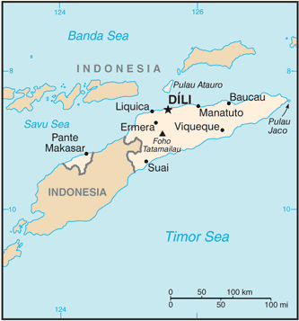 Map of Timor-Leste
Timor-Leste is an island of southern Indonesia not far from Australia. The island is divided by its colonial history. The eastern half was a Portuguese colony beginning in the 16th century. Portuguese colonizers introduced Christianity in the form of Roman Catholicism. The western half was associated with Indonesia, which was a Dutch colony during the colonial era.
The Japanese occupied the Dutch colony during World War II but had to give it up after they surrendered in 1945. Indonesia received its independence in 1949 and laid claim to the whole island of Timor. Timor-Leste made a declaration of independence in 1975 but was occupied by Indonesia. A bitter civil war erupted. A year later, Indonesia declared it its 27th province.
The civil war resulted in the deaths of as many as 250,000 people. It was not until 1999 that Indonesia finally ceded its political control over Timor-Leste. The Australian military has been instrumental in securing Timor-Leste for independence and has been serving as a peacekeeping force for internal security for the past decade. The United Nations (UN) recognized Timor-Leste as a sovereign independent country in 2002.
Timor-Leste has a population of about 1.291 million. About 98 percent of the population is Roman Catholic. The only other predominant Catholic country in Asia is the Philippines. About 90 percent of the population still works in agriculture. The country has had a difficult time establishing a stable government and reducing conflict. Almost all its infrastructure was damaged in the civil war and rebuilding has been slow. Poor and impoverished due to the civil war over independence, the country does have some opportunity derived from the large natural gas field in the vicinity. Timor-Leste has been working to gain control of its maritime boundaries to benefit from the offshore natural resources.
- Malaysia was a former British colony made up of various regions from both the Malay Peninsula and the island of Borneo. Modern Malaysia has diverse cultural dynamics and is modernizing its economy to compete with the core economic areas of the world.
- Singapore is an economic tiger that doesn’t have natural resources but makes good use of an excellent location. High-tech manufacturing has been Singapore’s main method of gaining wealth.
- Indonesia is made up of thousands of islands and hundreds of ethnic groups. Indonesia is the fourth-most populous country in the world and has the world’s largest Muslim population. More than half the population lives on the island of Java.
- The Philippines has more than ninety million people on thousands of islands. The country was colonized by Spain and was then a possession of the United States before it gained independence. Roman Catholicism and the English language are common in the Philippines, both of which augment a large outsourcing industry.
- Brunei is a small Muslim emirate with high incomes because of oil revenues. East Timor is half of a small island north of Australia. It is a former Portuguese colony and just gained its independence in 2002.
Vocabulary Terms
|
Formed from the nationalized colonies of the Dutch East India Company, which came under the administration of the Dutch government in 1800 |
|
|
A monotheistic religion based on the teachings of the prophet Muhammad |
|
|
The capital city of Indonesia and largest city in Southeast Asia |
|
|
This country is the world's leading producer of palm oil |
|
|
The second peninsula of mainland southeast Asia; the narrow strip of land serves as a bridge between the mainland and islands |
|
|
An independent country that is very small in an area and population |
|
|
The practice of having certain job functions done outside a company instead of having an in-house department or employee handle them; functions can be outsourced to either a company or an individual |
Applying Knowledge
Discussion and Study Questions
- Which European country colonized each of the Southeast Asian nations discussed in this lesson?
- What is the dominant religion in each country? Name the two Roman Catholic countries in Asia.
- What cultural and ethnic issues does Malaysia need to address?
- What type of economic activity has Singapore engaged in to gain wealth?
- How does the growth triangle that Singapore is engaged in work? How does each partner benefit?
- How does anentrepôtfit into the core-periphery spatial relationship in Southeast Asia?
- What environmental problems exist in Indonesia and the Philippines? Which are natural phenomena?
- Where are devolutionary forces active in Indonesia? How could the government address them?
- What are the three main regions of the Philippines? Which region has the largest population?
- What qualities or conditions are necessary for BPO?
Real-World Geography Exercise
- Using Google Maps, complete the following activities:
- Locate each place on the bulleted list below.
- Find the nearest city with an international airport in proximity to each location on the bulleted list below.
- Calculate the distance and travel time by plane to each city from the Newark Liberty International Airport in Newark, New Jersey.
- Using NASA Latitude and Longitude Finder, determine the latitude and longitude for each location on the bulleted list below.
- Be prepared to share and discuss your answers.
- Aceh
- Bali
- Borneo
- East Malaysia
- Java
- Luzon
- Mindanao
- Pinang
- Quezon
- Sarawak
- Sabah
- Sumatra
- Visayas
- West Papua
Current Events
Malaysia Timber Industry Still Growing Strong
Malaysia Making Rice Production More Environment-Friendly
Singapore Arrivals To Be Checked After Reported Monkeypox Outbreak
Singapore's Youngest Billionaire Kishin RK On How He Is Disrupting The Real Estate Industry
How This Trans Politico Is Changing Indonesia From The Inside
Videos for Geography Enrichment
Helpful Websites for the Study of Geography
Canadian Encyclopedia is an encyclopedia funded by the Canadian government covering all branches of knowledge. Their scholarly collection includes interactive materials.
CIA World Factbook provides information on the people, history, government, economy, energy, geography, communications, transportation, military, and transnational issues for the world's entities.
Congress.gov is a US government website where you can find federal legislation, past and present, as well as information about the US legal system.
Drug Enforcement Administration (DEA) is a government agency website that provides current news, resources, topics of interest, information about drugs, careers in the DEA, and a tip hotline.
Library of Congress is the largest library in the world and provides manuscripts, files, information, pictures, and videos.
NASA Earth Observatory (NEO) is a US government agency website that allows users to search for and retrieve satellite images of Earth.
National Archives is a US government website that provides historical documents, photos, records, publications, and educator resources.
National Oceanic and Atmospheric Association (NOAA) is a US government agency website that provides weather-related information and ocean research.
National Map is a website by the United States Geological Survey and other federal, state, and local agencies that delivers topographic information for the United States.
NationMaster is a massive central data source and a handy way to graphically compare nations.
Real-Time World Air Quality Index is a website that measures most locations in the world for air pollution in real time.
StateMaster is a unique statistical database, which allows you to research and compare a multitude of different data on US states.
United Nations (UN) is an international organization founded in 1945 and made up of 193 member states. The UN maintains international peace and security, protects human rights, delivers humanitarian aid, promotes sustainable development, and upholds international law.
United States Census Bureau is a US government agency that provides a population clock, data, surveys, statistics, a library with information and infographics, news about the economy, and much more.
United States Geological Survey (USGS) is a US government agency website that provides scientific information about the natural hazards that threaten lives, the natural resources we rely on, the health of our ecosystems and environment, and the impacts of climate and land-use change.
Whitehouse.gov is a US government website that provides the latest presidential news, information about the budget, policy, defense, and many more topics.
World Health Organization (WHO) is under the United Nations and provides leadership on matters critical to health, shapes the research agenda on health, and monitors the health situation and assessing health trends around the world. Their website provides information on the state of health around the world, outbreaks, current health news, and more.
World Trade Organization (WTO) is an intergovernmental organization that regulates international trade. The website provides information on the history of the multilateral trading system, featured videos, news and events, trade topics, and more.