
10.7: The Mainland Countries- Vietnam, Laos, Cambodia, Thailand, and Myanmar (1 day)
- Page ID
- 8258
\( \newcommand{\vecs}[1]{\overset { \scriptstyle \rightharpoonup} {\mathbf{#1}} } \)
\( \newcommand{\vecd}[1]{\overset{-\!-\!\rightharpoonup}{\vphantom{a}\smash {#1}}} \)
\( \newcommand{\dsum}{\displaystyle\sum\limits} \)
\( \newcommand{\dint}{\displaystyle\int\limits} \)
\( \newcommand{\dlim}{\displaystyle\lim\limits} \)
\( \newcommand{\id}{\mathrm{id}}\) \( \newcommand{\Span}{\mathrm{span}}\)
( \newcommand{\kernel}{\mathrm{null}\,}\) \( \newcommand{\range}{\mathrm{range}\,}\)
\( \newcommand{\RealPart}{\mathrm{Re}}\) \( \newcommand{\ImaginaryPart}{\mathrm{Im}}\)
\( \newcommand{\Argument}{\mathrm{Arg}}\) \( \newcommand{\norm}[1]{\| #1 \|}\)
\( \newcommand{\inner}[2]{\langle #1, #2 \rangle}\)
\( \newcommand{\Span}{\mathrm{span}}\)
\( \newcommand{\id}{\mathrm{id}}\)
\( \newcommand{\Span}{\mathrm{span}}\)
\( \newcommand{\kernel}{\mathrm{null}\,}\)
\( \newcommand{\range}{\mathrm{range}\,}\)
\( \newcommand{\RealPart}{\mathrm{Re}}\)
\( \newcommand{\ImaginaryPart}{\mathrm{Im}}\)
\( \newcommand{\Argument}{\mathrm{Arg}}\)
\( \newcommand{\norm}[1]{\| #1 \|}\)
\( \newcommand{\inner}[2]{\langle #1, #2 \rangle}\)
\( \newcommand{\Span}{\mathrm{span}}\) \( \newcommand{\AA}{\unicode[.8,0]{x212B}}\)
\( \newcommand{\vectorA}[1]{\vec{#1}} % arrow\)
\( \newcommand{\vectorAt}[1]{\vec{\text{#1}}} % arrow\)
\( \newcommand{\vectorB}[1]{\overset { \scriptstyle \rightharpoonup} {\mathbf{#1}} } \)
\( \newcommand{\vectorC}[1]{\textbf{#1}} \)
\( \newcommand{\vectorD}[1]{\overrightarrow{#1}} \)
\( \newcommand{\vectorDt}[1]{\overrightarrow{\text{#1}}} \)
\( \newcommand{\vectE}[1]{\overset{-\!-\!\rightharpoonup}{\vphantom{a}\smash{\mathbf {#1}}}} \)
\( \newcommand{\vecs}[1]{\overset { \scriptstyle \rightharpoonup} {\mathbf{#1}} } \)
\(\newcommand{\longvect}{\overrightarrow}\)
\( \newcommand{\vecd}[1]{\overset{-\!-\!\rightharpoonup}{\vphantom{a}\smash {#1}}} \)
\(\newcommand{\avec}{\mathbf a}\) \(\newcommand{\bvec}{\mathbf b}\) \(\newcommand{\cvec}{\mathbf c}\) \(\newcommand{\dvec}{\mathbf d}\) \(\newcommand{\dtil}{\widetilde{\mathbf d}}\) \(\newcommand{\evec}{\mathbf e}\) \(\newcommand{\fvec}{\mathbf f}\) \(\newcommand{\nvec}{\mathbf n}\) \(\newcommand{\pvec}{\mathbf p}\) \(\newcommand{\qvec}{\mathbf q}\) \(\newcommand{\svec}{\mathbf s}\) \(\newcommand{\tvec}{\mathbf t}\) \(\newcommand{\uvec}{\mathbf u}\) \(\newcommand{\vvec}{\mathbf v}\) \(\newcommand{\wvec}{\mathbf w}\) \(\newcommand{\xvec}{\mathbf x}\) \(\newcommand{\yvec}{\mathbf y}\) \(\newcommand{\zvec}{\mathbf z}\) \(\newcommand{\rvec}{\mathbf r}\) \(\newcommand{\mvec}{\mathbf m}\) \(\newcommand{\zerovec}{\mathbf 0}\) \(\newcommand{\onevec}{\mathbf 1}\) \(\newcommand{\real}{\mathbb R}\) \(\newcommand{\twovec}[2]{\left[\begin{array}{r}#1 \\ #2 \end{array}\right]}\) \(\newcommand{\ctwovec}[2]{\left[\begin{array}{c}#1 \\ #2 \end{array}\right]}\) \(\newcommand{\threevec}[3]{\left[\begin{array}{r}#1 \\ #2 \\ #3 \end{array}\right]}\) \(\newcommand{\cthreevec}[3]{\left[\begin{array}{c}#1 \\ #2 \\ #3 \end{array}\right]}\) \(\newcommand{\fourvec}[4]{\left[\begin{array}{r}#1 \\ #2 \\ #3 \\ #4 \end{array}\right]}\) \(\newcommand{\cfourvec}[4]{\left[\begin{array}{c}#1 \\ #2 \\ #3 \\ #4 \end{array}\right]}\) \(\newcommand{\fivevec}[5]{\left[\begin{array}{r}#1 \\ #2 \\ #3 \\ #4 \\ #5 \\ \end{array}\right]}\) \(\newcommand{\cfivevec}[5]{\left[\begin{array}{c}#1 \\ #2 \\ #3 \\ #4 \\ #5 \\ \end{array}\right]}\) \(\newcommand{\mattwo}[4]{\left[\begin{array}{rr}#1 \amp #2 \\ #3 \amp #4 \\ \end{array}\right]}\) \(\newcommand{\laspan}[1]{\text{Span}\{#1\}}\) \(\newcommand{\bcal}{\cal B}\) \(\newcommand{\ccal}{\cal C}\) \(\newcommand{\scal}{\cal S}\) \(\newcommand{\wcal}{\cal W}\) \(\newcommand{\ecal}{\cal E}\) \(\newcommand{\coords}[2]{\left\{#1\right\}_{#2}}\) \(\newcommand{\gray}[1]{\color{gray}{#1}}\) \(\newcommand{\lgray}[1]{\color{lightgray}{#1}}\) \(\newcommand{\rank}{\operatorname{rank}}\) \(\newcommand{\row}{\text{Row}}\) \(\newcommand{\col}{\text{Col}}\) \(\renewcommand{\row}{\text{Row}}\) \(\newcommand{\nul}{\text{Nul}}\) \(\newcommand{\var}{\text{Var}}\) \(\newcommand{\corr}{\text{corr}}\) \(\newcommand{\len}[1]{\left|#1\right|}\) \(\newcommand{\bbar}{\overline{\bvec}}\) \(\newcommand{\bhat}{\widehat{\bvec}}\) \(\newcommand{\bperp}{\bvec^\perp}\) \(\newcommand{\xhat}{\widehat{\xvec}}\) \(\newcommand{\vhat}{\widehat{\vvec}}\) \(\newcommand{\uhat}{\widehat{\uvec}}\) \(\newcommand{\what}{\widehat{\wvec}}\) \(\newcommand{\Sighat}{\widehat{\Sigma}}\) \(\newcommand{\lt}{<}\) \(\newcommand{\gt}{>}\) \(\newcommand{\amp}{&}\) \(\definecolor{fillinmathshade}{gray}{0.9}\)- Summarize the main economic activities of each country.
- Understand how Vietnam was divided by civil war and the impact the war had on the country.
- Realize how the country of Laos is addressing its rural landlocked economic situation.
- Describe the radical conditions that led to the creation of Democratic Kampuchea.
- Outline the physical geography of Thailand and how this country has developed its economy.
- Comprehend the conditions in Burma.
- Learn why the Burmese people would be opposing the government.
TEKS Regional Unit 10 East and Southeast Asia: Chapter 10.7 The Mainland Countries: Vietnam, Laos, Cambodia, Thailand, and Myanmar
WG.5A Analyze how the character of a place is related to its political, economic, social, and cultural elements.
WG.6B Explain the processes that have caused changes in settlement patterns, including urbanization, transportation, access to and availability of resources, and economic activities.
WG.9A Identify physical and/or human factors such as climate, vegetation, language, trade networks, political units, river systems, and religion that constitute a region.
WG.10B Classify where specific countries fall along the economic spectrum between free enterprise and communism.
WG.14B Compare how democracy, dictatorship, monarchy, republic, theocracy, and totalitarian systems operate in specific countries.
WG.15A Identify and give examples of different points of view that influence the development of public policies and decision-making processes on local, state, national, and international levels.
WG.17C Compare economic, political, or social opportunities in different cultures for women, ethnic and religious minorities, and other underrepresented populations.
WG.18B Assess causes, effects, and perceptions of conflicts between groups of people, including modern genocides and terrorism.
WG.18D Valuate the spread of cultural traits to find examples of cultural convergence and divergence such as the spread of democratic ideas.
WG.21B Locate places of contemporary geopolitical significance on a map.
WG.21C Create and interpret different types of maps to answer geographic questions, infer relationships, and analyze change.
WG.22A Design and draw appropriate graphics such as maps, diagrams, tables, and graphs to communicate geographic features, distributions, and relationships.
WG.22C Use geographic terminology correctly.
WG.22D Use standard grammar, spelling, sentence structure, and punctuation.
The Mainland Countries: Vietnam, Laos, Cambodia, Thailand, and Myanmar
Vietnam
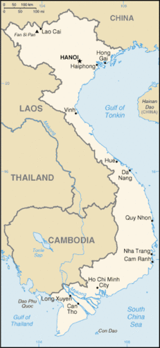 Map of Vietnam
The elongated state of Vietnam is slightly larger than Italy and about three times the size of the US state of New Mexico. In 2017 it was estimated to have a population of more than 96 million people. Sixty percent of the population is under age 21. This indicates that the population was only about half its current size at the end of the Vietnam War. Vietnam has two main urban core areas: Ho Chi Minh City (Saigon) in the south and the capital, Hanoi, in the north.
The middle region of Vietnam is narrow, with higher elevation. Each core area is located along a major river delta. The Red River delta is located east of Hanoi in the north, and the mighty Mekong River delta is located next to Saigon in the south. These river deltas deposit silt from upstream and provide excellent farmland for growing multiple crops of rice and food grains per year. Vietnam has a tropical type A climate with a long coastline. Fishing provides protein to balance out nutritional needs.
More than 55 percent of the population works in agriculture. Family size has dropped dramatically because of population growth and a trend toward urbanization. Rural-to-urban shift has caused the two main urban core cities to grow rapidly. Saigon is the largest city in Vietnam and has a port that can accommodate oceangoing vessels. Hanoi, the capital, is not a port city and is located inland from the nearest port of Haiphong on the coast of the Gulf of Tonkin.
Political Geography of Vietnam
An understanding of Vietnam is not complete without understanding the changes in political control the country of Vietnam has experienced. Different Chinese dynasties controlled Vietnam at different times. When France colonized Vietnam, it imposed the French language as the lingua franca and Christianity as the main religion. Both changes met resistance, but the religious persecution of Buddhism by the French colonizers created harsh adversarial conditions within the culture.
The French domination started in 1858. The Japanese replaced it in 1940, and this lasted until the end of World War II. With the defeat of Japan in 1945, the French desired to regain control of Vietnam. The French aggressively pushed into the country, but met serious resistance and were finally defeated in 1954 with their loss at the battle of Dien Bien Phu.
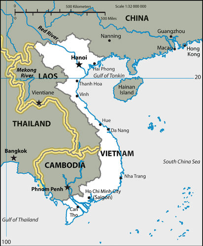 The two main cities of Vietnam are both located next to large rivers. The capital, Hanoi, in the north is on the Red River. Ho Chi Minh City (Saigon) to the south is next to the delta of the Mekong River.
In the mid-1950s, the Vietnamese began asserting their request for an independent country. The dynamics were similar to that of Korea. After 1954, Vietnam needed to establish a government for their independent country. They were not unified. The northern section rallied around Hanoi and was aligned with Communist ideology. The southern region organized around Saigon and aligned itself with capitalism and democratic reforms.
During the Cold War, the United States opposed Communism wherever it emerged. Vietnam was one such case. Supporting South Vietnam against the Communists in the north started not long after the defeat of France. By 1960, US advisers were working to bolster South Vietnam’s military power. After the assassination of John F. Kennedy, President Lyndon Johnson had to make a choice to either pull out of Vietnam or push the US military to fully engage the Communists in North Vietnam.
Not wishing Vietnam and its neighbors to “go Communist” through a domino effect—where if one country fell to Communism its neighbors would follow—President Johnson decided to escalate the war in Vietnam. By 1965, more than one half of a million US soldiers were on the ground in Vietnam. Just as Vietnam was divided by political and economic ideology, the Vietnam War also divided the US population. Protests were common on college campuses and public support for the war was often met with public opposition.
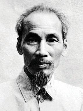 Portrait of Ho Chi Minh, the Communist Leader of North Vietnam during the Cold War.
The US government, under President Richard Nixon, finally decided to pull all US troops out from Vietnam after a cease-fire was agreed upon in a Paris peace conference in 1973. More than 57,000 US soldiers had died in the Vietnam War. Two years later, in 1975, the North Vietnamese Communists invaded South Vietnam and took control of the entire country. Vietnam was unified under a Communist regime.
More than two million people from South Vietnam escaped as refugees and fled to Hong Kong, the United States, or wherever they could go. Thousands were accepted by the United States, which caused ethnic rifts in US communities. The United States placed an embargo on Vietnam and refused to trade with them. The United States did not open diplomatic relations with Vietnam again until 1996. The Vietnam War devastated the infrastructure and economy of the country. Roads, bridges, and valuable distribution systems were destroyed. Vietnam could only turn to what it does best: growing rice and food for its people.
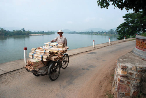 Man hauling cut wood on a bicycle cart near the city of Hue, Vietnam.
Modern Vietnam
For the past three decades, Vietnam has been recovering and slowly integrating itself with the outside world. Its population has doubled; most of the population was born after the Vietnam War. Their main goal is to seek out opportunities and advantages to provide for themselves and their families. Vietnam has been a rural agrarian society. The two main core cities, however, are now waking up to the outside world, and the outside world is discovering them.
Looking for cheap labor and economic profits, economic tigers such as Taiwan are turning to Saigon to set up light manufacturing operations. People from the rural areas are migrating to the cities looking for employment. Saigon has more than 8.5 million people and has a special economic zone (SEZ) located nearby, so rural-to-urban shift is taking place.
After 1975, the city of Saigon was renamed Ho Chi Minh City after the victorious Communist leader, Ho Chi Minh. Many of the people who live there and who live in the United States still refer to it as Saigon.
Any country that experiences rapid urbanization or economic change suffers from growing pains. Conflicts usually erupt over control of resources and land ownership, ethnic groups usually vie for power, and environmental damage is usually extensive. All of these issues are evident in Vietnam. The Communist government has acted to moderate both the problems and the economic growth.
The future of Vietnam may be similar to most of Southeast Asia as it balances out the strong forces of local culture and the demands of a competitive global economy. The growing population will add to the demand for resources and employment opportunities. Vietnam has been a relatively poor country but it still has been able to export rice and other agricultural products. In recent years, the Communist government has implemented a series of reforms moving toward a market economy, which has encouraged economic development and international trade.
Globalization has prompted a strong rural-to-urban shift within Vietnam. The rural countryside is steeped in its agrarian heritage based on growing rice and food crops, but the urban centers have been energized by modern technology and outside economic interest. Vietnam has enormous growth potential. The country’s urban centers are shifting from stage 2 of the index of economic development into stage 3, where the urbanization rates are the strongest.
The rapid rise of the global economy that is connected to Vietnam’s major cities has provided jobs and opportunities that are highly sought after by the growing population. The city streets are filled with motorbikes and bicycle traffic. Cars are becoming more plentiful. Ho Chi Minh city has been a major destination for the export textile industry and other industries seeking a cheap labor base. Cell phones and Internet services have connected a once-isolated country with the rest of the world.
Laos
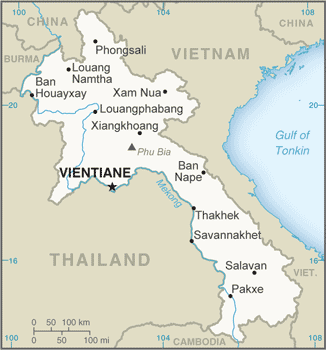 Map of Laos
The geography of Laos centers on the Mekong River basin and rugged mountain terrain. Laos is landlocked. Vietnam shields Laos from the South China Sea to the east and Cambodia to the south. It does not have a port city to the outside world. The mountains reach up to 9,242 feet. The Type A climate provides a rainy season and a dry season. The rains usually fall between May and November, followed by a dry season for the remainder of the year. The Mekong River flows through the land and provides fresh water, irrigation, and transportation. The country’s capital and largest city, Vientiane, is located on the Mekong River. Laos is about the same size in area as the US state of Utah.
The Lao Kingdom coalesced in the 1500s and was eventually absorbed by the Kingdom of Siam, which thrived during the 18th and 19th centuries. France came in during the colonial era and created a French Indochina. Laos received independence from France in 1949. Laos is a rural country with about 80 percent of the population working in agriculture.
Globalization has not yet been established in this country and infrastructure is less developed. Electricity is not available on a consistent basis and transportation systems are basic. There are not any railroads and there are few paved roads. Clean water for human consumption is not always available. The economy is based on agriculture, with some outside investments in mining and natural resources.
Two-thirds of the people in Laos are Buddhists. Animist traditions and spirit worship have the next highest percentage of followers. Muslims and Christians make up a small percentage of the population. Lao make up the largest ethnic group and 70 percent of the population. Other ethnicities include the Hmong and mountain tribal groups, which can be found in various remote regions of the country.
The remoteness and rural heritage of the many tribal people have started to attract tourism. Tourism has increased in recent years, partially due to the Chinese government allowing its citizens to travel outside their borders from China into Laos. Laos has two UNESCO World Heritage Sites: the historic town of Luang Prabang, and the southern site of Wat Phou (Vat Phu), which is an ancient Hindu temple complex.
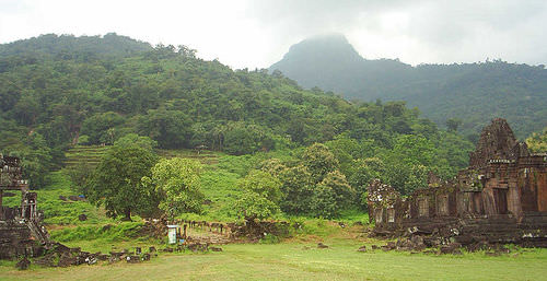 Vat Phou is a ruined Khmer Hindu temple complex in southern Laos. It is located at the base of mount Phu kao, some 3.7 miles from the Mekong in Champasak Province.
Laos is a poor country. It has fewer employment opportunities for its citizens than other developing countries have. The one-party Communist political system of the Cold War has been decentralizing control and working to encourage entrepreneurial activities. Foreign investments are increasing in the areas of mining, hydroelectric production, and major construction projects.
The World Bank and other agencies have supported efforts to improve infrastructure and provide opportunities for the people of Laos. China has been partnering with the Laotian government to help build rail transport in the country. These efforts have assisted in reducing poverty and increasing the economic and physical health of the country.
Cambodia
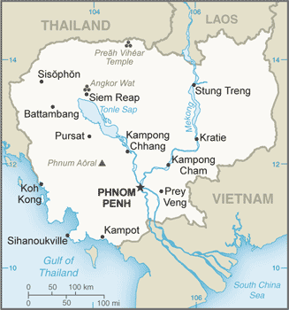 Map of Cambodia
A Notorious History
Cambodia is about the same size in area as the US state of Missouri. The population in 2017 was estimated at more than 16.2 million. The Khmers created the Angkor Empire, which reached its peak between the 10th and 13th centuries. Preceding the colonial period, the Angkor Empire entered into a long era of decline.
France took control of the region in the latter part of the 17th century. Japan took control of the region before World War II and then relinquished it when they surrendered to end World War II. France regained control of Cambodia after the Japanese army was defeated. Cambodia finally received independence from France in 1953.
To understand Cambodia, one has to understand its recent history. This country has undergone some of the most extreme social transitions in modern times. The Khmer Rouge, under the leadership of Pol Pot, turned society upside down, giving the country a legacy that it will carry forward as integration continues into the world community.
Between 1969 and 1973, while the United States was fighting the Vietnam War, US forces bombed and briefly invaded Cambodia in an effort to disrupt the North Vietnamese military operations and oppose the Khmer Rouge. Millions of Cambodians were made refugees by the war, and many ended up in Phnom Penh. The number of casualties from the US bombing missions in Cambodia is unknown.
The US war in Vietnam had spilled over into Laos and Cambodia and advanced the opportunities for the Khmer Rouge regime to gain power. Pol Pot’s Communist forces of the Khmer Rouge finally captured Cambodia’s capital of Phnom Penh in 1975. The Khmer Rouge evacuated all cities and towns and forced the people to move to the rural areas.
The country’s name was changed to Democratic Kampuchea. China’s Great Cultural Revolution and the Great Leap Forward disaster were influential for Pol Pot’s radical experiment. Since Vietnam was supported by the Union of Soviet Socialist Republics (USSR), the Khmer Rouge looked to China for arms and support.
Pol Pot was creating an agricultural model for a new country based on 11th-century ideals. People in urban areas were forcibly marched off into the countryside for labor in agriculture. Anyone who resisted or even hinted at rebellion was killed. All traces of Westernized ideas, technology, medical practice, religion, or books were destroyed. Thousands of people were systematically killed in an attempt to bring into being a rural agrarian utopian society.
The thousands who were systematically eliminated gave rise to the term Killing Fields, meaning fields where massive groups of people were forced to dig their own graves and then were killed. The mass killings were reminiscent of those carried out by Hitler, Stalin, and Mao. Pol Pot’s regime also targeted ethnic minority groups. Muslims and Chinese suffered serious purges. Professional, educated people, such as doctors, lawyers, and teachers, were also targeted for execution.
According to some reports, the very act of wearing eyeglasses was a death sentence as it was a symbol of intellectualism. In a country of eight million in 1970, more than two million people were executed or died as a result of Pol Pot’s policies. The total number will never be known. Hundreds of thousands became refugees in neighboring countries.
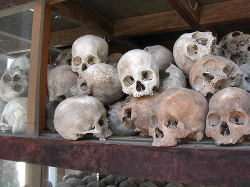 Skulls of the victims from the killing fields of Pol Pot and the Khmer Rouge in Cambodia from the 1970s.
By 1978, the Khmer Rouge was isolated in the countryside. Vietnamese forces controlled the urban areas. A decade of civil war and unrest followed. Paris peace talks, cease-fires, United Nations–sponsored elections and coalition governments have since helped provide political stability. Pol Pot died under unclear circumstances in 1998 while being held under house arrest. As of 1999, the Khmer Rouge elements that were still in existence had surrendered or were arrested. Many of the Khmer Rouge leaders were charged with crimes against humanity by the United Nations–sponsored tribunals.
Modern Cambodia
Cambodia is working to become a democratic and open country with established trade relationships with global markets. The people have struggled to create a stable society that can rebound from their legacy of turmoil and conflict. The country’s population is relatively young. The rural areas and the generations who remain there continue to lack the basic amenities of modern society. Education, electricity, and modern infrastructure are lacking. More than half the population works in agriculture. Since less than 25 percent of the population lives in cities, Cambodia is likely to experience a high rural-to-urban shift in its future.
 Age Structure of Cambodia: 0-14 years: 31.01 percent (male 2,537,753/female 2,487,633); 15-24 years: 18.36 percent (male 1,471,965/female 1,503,977); 25-54 years: 40.68 percent (male 3,229,901/female 3,361,475); 55-64 years: 5.69 percent (male 374,663/female 547,971); 65 years and over: 4.25 percent (male 258,584/female 430,564)
People are returning to religious practices that were banned during the Pol Pot era. Buddhism is the dominant religion of about 95 percent of the population. Small percentages of the population also practice Christianity, Hinduism, Islam, or tribal beliefs. There are at least 20 distinct hill tribes that hold to their own traditions and cultural ways. The country has historically been self-sufficient with food, but the rapid population growth, political instability, and lack of infrastructure are challenging the future of the country.
Agriculture has been the main economic activity, though textiles (clothing manufacturing) have increased in recent years because of the low cost of labor combined with an abundant workforce. The international business sector has sought to exploit this opportunity, but multinational corporations are hesitant to invest in a country that suffers from political instability or a high level of corruption within the public and private sector.
 Angkor Wat is said to be the largest religious structure in the world.
Cambodia has been attempting to build a sustainable economy. The textile industry is the number one source of national wealth. Sweatshops and low-tech manufacturing have begun to take root in the expanding capital city of Phnom Penh. Tourism is another sector that has experienced rapid growth. Though nonexistent in earlier decades, tourism is becoming more popular. Cambodian tourism provides travelers with an experience that is more pristine and less commercialized. Tourism has been rated as the second-largest sector of the economy.
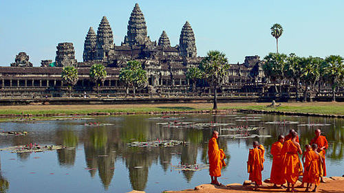
One of the main sites that attract many visitors is the extraordinary ancient site of Angkor Wat (Angkor means “city” and Wat “temple”). This site is one of the best-preserved showcases of Khmer architecture from its early empire years. Angkor Wat is being developed as a major tourist attraction. The 12th-century complex was first a Hindu site dedicated to Vishnu, and then it was converted to a Buddhist site.
Angkor Wat has become an international tourist destination. It is one of the largest temple complexes in existence in the world and is a UNESCO World Heritage Site. The city of Angkor has been estimated to have been the largest city in the world at its peak. As many as 1,000 other temples and ancient structures have been recovered in the same area in recent years.
Cambodia has pressing environmental problems. The United Nations has designated the country as the nation with the third-highest number of land mines on Earth. Since 1970, more than 60,000 people have been killed, and many more injured or maimed because of unexploded land mines in rural areas.
The growing population, attempting to recover from decades of devastation, has cut down the rainforest at one of the highest rates in the world. In 1970, rainforests covered about 70 percent of the country. Today there is only about three percent of the rainforest left. A rise in the need for resources, along with illegal timber activities, has devastated the forests, resulting in a high level of soil erosion and loss of habitat for indigenous species. The loss of natural resources is likely to hinder the country’s economic growth.
Thailand
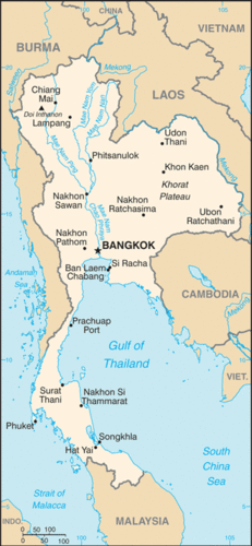 Map of Thailand
Thailand is larger than Laos and Cambodia combined but smaller than Burma. The physical regions that make up Thailand include the mountainous north, where peaks reach up to 8,415 feet; the large southeastern plateau bordering the Mekong River; and the mainly flat valley that dominates the center of the country. The southern part of the country includes the narrow isthmus that broadens out to create the Malay Peninsula.
The tropical Type A climate has dry and rainy seasons similar to Cambodia. The weather pattern in the main part of Thailand, north of the Malay Peninsula, has three seasons. The main rainy season lasts between June and October, when the southwest monsoon arrives with heavy rain clouds from over the Indian Ocean.
After the rainy season, the land cools off and starts to receive the northeast monsoon, which is a cool dry wind that blows from November to February. Considered the dry season, its characteristics are lower humidity and cooler temperatures.
From March to May, the temperatures rise and the land heats up. Then the cycle starts over again with the introduction of the rainy season. The weather pattern in the southern part of Thailand in the Malay Peninsula receives more rain throughout the year, with two rainy seasons that peak from April through May and then again from October through December.
Thailand was formerly known as the Kingdom of Siam. In 1932, a constitutional monarchy was established after a revolution. The name was officially changed to Thailand in 1939. The ruling monarch remains head of state but a prime minister is head of the government. Siam was never colonized by either the Europeans or the Japanese. The leaders of Siam played France and Britain against each other and remained independent of colonial domination.
During World War II, the Japanese did extend influence in the region. Thailand briefly engaged the Japanese military in World War II but worked out an armistice that used the Japanese military to regain territories lost to Britain or France. At the same time, Thailand was working to support Allied efforts in the region.
About three-fourths of the population is ethnically Thai. There is a noticeable Chinese population and a small percentage of people who are ethnically Malay. There are various minority groups and hill tribes. The country’s official language is Thai. Buddhism is adhered to by about 95 percent of the population. The ruling monarch is considered the defender of the Buddhist faith. Southern Buddhism is fervently practiced here. Thailand does not use the Western Gregorian calendar.
Thailand uses an official calendar based on an Eastern translation of the Buddhist era, which essentially adds 543 years to the Gregorian calendar. For example, when it was 2010 C.E. in the West, it was 2553 in Thailand.
There have been clashes between Thailand’s small Muslim minority groups in the south, which have been increasing since 9/11. Islamic influences have been increasing near the border with Malaysia, which is about 60 percent Muslim. The Buddhist government of Thailand has sought to keep extremist groups like Al-Qaeda from operating within its borders. A series of Muslim-inspired bombings in recent years have increased social tensions and brought more attention to the religious division in the south.
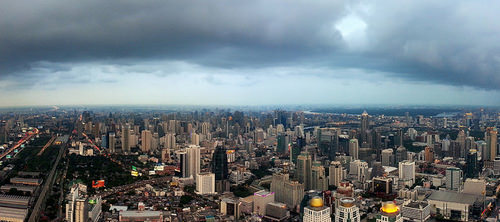 Modern city of Bangkok with high-rise office buildings and business district.
Thailand has an excellent record of economic growth and has been one of Southeast Asia’s best performers in the past couple of decades. Thailand is developing its infrastructure and has established measures to attract foreign investments and support free-enterprise economic activities. The recent slowdown in the global economy and internal political problems have caused a sharp downturn in Thailand’s economic growth. Nevertheless, Thailand remains a strong economic force and one of the best economies in the region. The positive indicators include a strong focus on infrastructure, industrial exports, and tourism.
Urbanization rates are increasing; at least one-third of the population lives in cities. Family size has fallen to lower than two children per family, while education rates have increased. The country has also tapped into its natural resources for export profits as the world’s third-largest exporter of tin and the second-largest exporter of tungsten. Light manufacturing has taken off and become a major component of the economy, accounting for about 45 percent of the gross domestic product (GDP). The country is a major manufacturer of textiles, footwear, jewelry, auto parts, and electrical components. Thailand has been the major exporter of rice in the world and has a strong agricultural base.
Thailand is a newly industrialized country and is working on building national wealth: a balance of agriculture, extractive activities, manufacturing, and postindustrial activities (tourism). Thailand is considered the third-largest manufacturer of motor vehicles in Asia, after Japan and Korea. Vehicle producers from the United States and Asia are manufacturing large numbers of cars and trucks in Thailand.
Toyota dominates the market in both truck and auto production. Truck production is increased by Mitsubishi, Nissan, Chevrolet, Ford, and Mazda. Honda, from Japan, and the Tata Motor Corporation, from India, are expanding their operations in Thailand. Thailand is in a good position to advance its economy and shift the whole country into the next stage of development to become a major participant in the global economic marketplace.
The tourism industry has grown immensely in Thailand over the past few decades. Green and lush tropical mountain landscapes, the exquisite architecture of ancient Buddhist temples, and beautiful golden beaches along warm tropical coastlines make for an excellent tourism market. Some of the best world-class tropical beach resorts are located along the sandy and sunny shores of Thailand. The country is open to outsiders and has welcomed tourism as part of its economic equation. The relatively stable country provides a safe and exciting tourism agenda that has a global clientele.
The country of Thailand has the potential to recover from the global economic downturn and once again claim its role as an economic tiger of Southeast Asia. If political stability serves to enhance economic investments, the country will continue to experience economic growth. The low population growth is a model for other countries in the region. Thailand provides a good example of the theory that as a country urbanizes and industrializes, family size will usually go down.
Thailand is also moving forward in the index of economic development. It is in stage 3, where there is a strong rural-to-urban shift in the population. The capital city of Bangkok has stage 4 development patterns and is an economic core area for the country and the region. As large as New York City, Bangkok has developed into the political, cultural, and economic center of Southeast Asia. Often referred to as the “Venice of the East” because of its city canals, Bangkok has become a global city with a population of more than eight million people.
Myanmar (Burma)
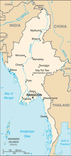 Map of Myanmar (Burma)
The Union of Myanmar (Union of Burma) is the official name for Burma. Since 1989, the military authorities in Burma have promoted the name Myanmar as a conventional name for their state. The US government and many other governments have not recognized or accepted the name change. Some groups within Burma do not accept the name because the translation of Myanmar is also the name of an ethnic minority in Burma. The use of the name Burma or Myanmar is split around the world and within the country.
Myanmar is the largest country on the Southeast Asian mainland in terms of physical area. It is about the same size in area as the US state of Texas and had a population in 2017 of more than 55 million. The country has a central mass with a southern protrusion that borders Thailand toward the Malay Peninsula. The northern border area between India and China has high mountains that are part of the Himalayas, with towering peaks extending to 19,295 feet. The Irrawaddy River cuts through the center of the country from north to south, creating a delta in the largest city, Rangoon. Most of the country’s population lives along this river valley.
There are differences in the physical landscape between the north and south. The northernmost area is mountainous with evergreen forests. Cool temperatures are found in the north and warmer annual temperatures are found in the south. To the west of the Irrawaddy River and north of Mandalay the land cover is mainly deciduous forests. The eastern region from Mandalay to the Laos border is scrub forests and grasslands. This area is considered the dry zone, with an annual rainfall of about 40 inches.
The more tropical south and coastal areas can receive higher levels of precipitation. The area around the core city of Mandalay was a major focus of agricultural development before British colonialism. Dryland crops were most common. During the colonial era, the British looked to the rich farmlands of the southern Irrawaddy delta and emphasized Rangoon as the center of their exploitations. Wetland rice is a major crop of the southern Irrawaddy basin. The southwest and the southern protrusion are mainly tropical evergreen forests. There has been oil exploration along the coastal regions of the Bay of Bengal and along the Andaman Sea.
The country was colonized by the British and was once a part of Great Britain’s empire in South Asia as a province of India. Burma was one of the most prosperous colonies of Britain until World War II, when the Japanese invaded and war devastated the region. Democratic rule existed from 1948 until 1962, when an authoritarian military dictatorship took over the country. A revolutionary council ruled the country between 1962 and 1974. This government nationalized most of the businesses, factories, and media outlets. The overall operating principle of the council was a concept called the Burmese Way of Socialism. This concept was based on central planning and Communist principles mixed with Buddhist beliefs.
Between 1974 and 1988, the sole political party of the country was the Burma Socialist Program Party, which was controlled by the same military general and his comrades who had been in control for decades. During this time, the rest of the world was advancing in technology and economic development and moving forward with advancements in health care and education. Burma remained an impoverished and isolated nation. A number of countries, including the United States, have trade restrictions with Burma. For decades, the authoritarian regime in Burma has been accused of serious human rights violations, which have largely been ignored by the outside world.
Protests against the military rule have always existed in Burma but have been suppressed by the armed forces and the authoritarian government. In 1962, the government cracked down on demonstrations at Rangoon University, resulting in 15 students being killed and many others in need of medical attention. The military government has taken serious action against any anti-government protest activities.
By 1988, the people of Burma were taking to the streets with widespread demonstrations and protests against the government over claims of oppression, mismanagement, and lack of democratic reforms. A total crackdown on the people was implemented, with thousands of protesters killed. A new council led by a military general created the State Law and Order Restoration Council a year later. Martial law was imposed and even harsher policies were imposed on anyone opposing the government. This is when the name of Myanmar was first used for the country.
The name change and the military rule have not been universally accepted. The United States still refers to the capital city as Rangoon, not as Yangon. In 2006, military rulers moved the capital north to the city of Naypyidaw. The purpose of the move was to establish a forward capital and shift development and political energy more toward the center of the country, rather than along the coast.
World nations are divided on the issues of how to deal with the changes and the military regime in Burma. The governments of some countries believe more sanctions should be implemented to force the leadership into compliance. Other countries believe sanctions are not effective against the government; that is, sanctions harm the people and do not affect the military leadership. Countries on this side of the equation believe that open trade is the best policy.
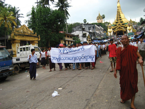 The banner refers to a national movement to promote nonviolence.
Anti-government protests erupted in 2007 when the military-ruled government allowed prices on fuel and energy to double and triple in price. Protesters were quickly and violently dealt with and many were arrested and jailed. Later that year, thousands of Buddhist monks led a peaceful protest to gain the government’s attention to make democratic changes. The demonstration ended in a renewed government crackdown.
Another voice in the anti-government demonstrations has been that of opposition leader Aung San Suu Kyi, a United Nation's worker in the early 1960s and a Nobel Peace Prize winner in 1991. Her opposition to the military rule has led to imprisonment and house arrest for decades. She has been a symbol of the opposition and hope for democratic reforms. In 2010, Aung San Suu Kyi was at long last released from house arrest and allowed more freedom of movement under government restrictions.
Burma has been placed in the same category as North Korea and Somalia in terms of authoritarian rule, lack of human rights, and stagnant economy. Economic conditions are poor. The military rulers have gained control of the main income-generating enterprises in the country, including the lucrative drug trade from the opium growing region of the northern Golden Triangle, where Burma borders Laos and Thailand. All factors seem to indicate an increase in opium production in recent years.
Precious gemstones such as rubies, sapphires, and jade are abundant in Burma. Rubies bring the highest incomes. Burma produces about 90 percent of the world’s supply. The Valley of Rubies in the north is noted for quality gem production of both rubies and sapphires. Most of the gems are sold to buyers in Thailand. All the profits go to Burma’s military rulers in the government. Since there is a high level of corruption within the government and business, the income from the gems produces limited economic development for the main population and discourages foreign investment in the country.
Burma has become one of the poorest countries in Southeast Asia. China has emerged as the main trading partner with Burma and has been propping up the dictatorial military regime. China supplies the regime with arms, constructs many of the infrastructure projects, and supplies natural gas to the country.
Burma is ethnically diverse. Though it is difficult to verify, the government of Burma recognizes one 135 distinct ethnic groups within its borders. It is estimated that there are over 100 different ethnolinguistic groups in Burma. About 90 percent of the population is Buddhist. This high level of diversity can allow for strong centrifugal forces that are not generally conducive to unity and nationalism. The heavy emphasis on the national military is one of the only centripetal forces within the population, even though the military leadership is also looked at with distain by those desiring more openness and democratic conditions.
France and Britain colonized the mainland region of Southeast Asia. Burma was a British colony and the rest was under French colonial rule. The Japanese took control of the region briefly before World War II ended in 1945. Siam was the only area not colonized. Siam became the country of Thailand.
Vietnam was divided by a Communist north and a capitalist south during the Cold War. Vietnam is emerging from decades of isolation to provide the global economy with a large low-cost labor pool that has been attracting foreign investments by multinational corporations.
The rural and landlocked nation of Laos has strong Buddhist traditions and an agrarian society.
Cambodia was impacted by the Vietnam War and then by the devastation of Pol Pot’s Khmer Rouge radical experiment in agrarian socialism, which killed as many as 2.5 million people. Recovery has been slow, but the textile industry and tourism have contributed to economic growth.
The Buddhist country of Thailand has been experiencing major economic development in recent decades and has established itself as a major economic power in the region. The modern capital city of Bangkok is a major center of manufacturing and cultural activities.
The people of Burma (Myanmar) continue to suffer under an authoritarian regime that offers few civil rights or democratic processes to its people. Poor, isolated, and militarily controlled, Burma has been at the center of many human rights violations in recent decades with little response from the international community.
Vocabulary Terms
|
A temple built in the Khmer Empire and dedicated to the Hindu God, Vishnu |
|
|
An alliance that promotes economic growth and peace in Southeast Asia: Association of South East Asian Nations |
|
|
A system in which the government holds nearly all political power and the means of production |
|
|
The political theory that if one nation comes under Communist control then neighboring nations will also come under communist control |
|
|
In Southeast Asia, it includes Vietnam, Cambodia and Laos |
|
|
A river in central Myanmar formed by the confluence of the Mali and Nmai Rivers; rice is grown here |
|
|
Formed in 1968, it was the name given to the followers of the Communist Party of Kampuchea in Cambodia |
Applying Knowledge
Discussion and Study Questions
- What are the main physical features and qualities of the mainland region of Southeast Asia?
- What are the two main core areas of Vietnam? Which river is associated with each city?
- What prompted the United States to enter into the conflict in Vietnam? Did Vietnam attack the United States?
- What river flows through parts of Laos? What is the main economic activity in Laos?
- What geographic aspect isolates the country of Laos and restricts its globalization efforts?
- Who was Pol Pot? What type of society did he attempt to create? What were some of his methods?
- What were the Killing Fields? What people were targeted to be eliminated? Why were these people killed?
- What attracts tourism to Cambodia, Laos, or Thailand? Why aren’t more tourists going to Burma?
- What is the main religion in Southeast Asia? Who is considered the defender of this faith?
- Who is Aung San Suu Kyi? How is she a reflection of conditions in her country?
Real-World Geography Exercise
- Using Google Maps, complete the following activities:
- Locate each place on the bulleted list below.
- Find the nearest city with an international airport in proximity to each location on the bulleted list below.
- Calculate the distance and travel time by plane to each city from the Logan International Airport in Boston, Massachusetts.
- Using NASA Latitude and Longitude Finder, determine the latitude and longitude for each location on the bulleted list below.
- Be prepared to share and discuss your answers.
- Andaman Sea
- Malay Peninsula
- Mandalay
- Naypyidaw
Videos for Geography Enrichment
Helpful Websites for the Study of Geography
Canadian Encyclopedia is an encyclopedia funded by the Canadian government covering all branches of knowledge. Their scholarly collection includes interactive materials.
CIA World Factbook provides information on the people, history, government, economy, energy, geography, communications, transportation, military, and transnational issues for the world's entities.
Congress.gov is a US government website where you can find federal legislation, past and present, as well as information about the US legal system.
Drug Enforcement Administration (DEA) is a government agency website that provides current news, resources, topics of interest, information about drugs, careers in the DEA, and a tip hotline.
Library of Congress is the largest library in the world and provides manuscripts, files, information, pictures, and videos.
NASA Earth Observatory (NEO) is a US government agency website that allows users to search for and retrieve satellite images of Earth.
National Archives is a US government website that provides historical documents, photos, records, publications, and educator resources.
National Oceanic and Atmospheric Association (NOAA) is a US government agency website that provides weather-related information and ocean research.
National Map is a website by the United States Geological Survey and other federal, state, and local agencies that delivers topographic information for the United States.
NationMaster is a massive central data source and a handy way to graphically compare nations.
Real-Time World Air Quality Index is a website that measures most locations in the world for air pollution in real time.
StateMaster is a unique statistical database, which allows you to research and compare a multitude of different data on US states.
United Nations (UN) is an international organization founded in 1945 and made up of 193 member states. The UN maintains international peace and security, protects human rights, delivers humanitarian aid, promotes sustainable development, and upholds international law.
United States Census Bureau is a US government agency that provides a population clock, data, surveys, statistics, a library with information and infographics, news about the economy, and much more.
United States Geological Survey (USGS) is a US government agency website that provides scientific information about the natural hazards that threaten lives, the natural resources we rely on, the health of our ecosystems and environment, and the impacts of climate and land-use change.
Whitehouse.gov is a US government website that provides the latest presidential news, information about the budget, policy, defense, and many more topics.
World Health Organization (WHO) is under the United Nations and provides leadership on matters critical to health, shapes the research agenda on health, and monitors the health situation and assessing health trends around the world. Their website provides information on the state of health around the world, outbreaks, current health news, and more.
World Trade Organization (WTO) is an intergovernmental organization that regulates international trade. The website provides information on the history of the multilateral trading system, featured videos, news and events, trade topics, and more.