
1.2: Human Activity and the Environment (7 Days)
- Page ID
- 1866
\( \newcommand{\vecs}[1]{\overset { \scriptstyle \rightharpoonup} {\mathbf{#1}} } \)
\( \newcommand{\vecd}[1]{\overset{-\!-\!\rightharpoonup}{\vphantom{a}\smash {#1}}} \)
\( \newcommand{\id}{\mathrm{id}}\) \( \newcommand{\Span}{\mathrm{span}}\)
( \newcommand{\kernel}{\mathrm{null}\,}\) \( \newcommand{\range}{\mathrm{range}\,}\)
\( \newcommand{\RealPart}{\mathrm{Re}}\) \( \newcommand{\ImaginaryPart}{\mathrm{Im}}\)
\( \newcommand{\Argument}{\mathrm{Arg}}\) \( \newcommand{\norm}[1]{\| #1 \|}\)
\( \newcommand{\inner}[2]{\langle #1, #2 \rangle}\)
\( \newcommand{\Span}{\mathrm{span}}\)
\( \newcommand{\id}{\mathrm{id}}\)
\( \newcommand{\Span}{\mathrm{span}}\)
\( \newcommand{\kernel}{\mathrm{null}\,}\)
\( \newcommand{\range}{\mathrm{range}\,}\)
\( \newcommand{\RealPart}{\mathrm{Re}}\)
\( \newcommand{\ImaginaryPart}{\mathrm{Im}}\)
\( \newcommand{\Argument}{\mathrm{Arg}}\)
\( \newcommand{\norm}[1]{\| #1 \|}\)
\( \newcommand{\inner}[2]{\langle #1, #2 \rangle}\)
\( \newcommand{\Span}{\mathrm{span}}\) \( \newcommand{\AA}{\unicode[.8,0]{x212B}}\)
\( \newcommand{\vectorA}[1]{\vec{#1}} % arrow\)
\( \newcommand{\vectorAt}[1]{\vec{\text{#1}}} % arrow\)
\( \newcommand{\vectorB}[1]{\overset { \scriptstyle \rightharpoonup} {\mathbf{#1}} } \)
\( \newcommand{\vectorC}[1]{\textbf{#1}} \)
\( \newcommand{\vectorD}[1]{\overrightarrow{#1}} \)
\( \newcommand{\vectorDt}[1]{\overrightarrow{\text{#1}}} \)
\( \newcommand{\vectE}[1]{\overset{-\!-\!\rightharpoonup}{\vphantom{a}\smash{\mathbf {#1}}}} \)
\( \newcommand{\vecs}[1]{\overset { \scriptstyle \rightharpoonup} {\mathbf{#1}} } \)
\( \newcommand{\vecd}[1]{\overset{-\!-\!\rightharpoonup}{\vphantom{a}\smash {#1}}} \)
\(\newcommand{\avec}{\mathbf a}\) \(\newcommand{\bvec}{\mathbf b}\) \(\newcommand{\cvec}{\mathbf c}\) \(\newcommand{\dvec}{\mathbf d}\) \(\newcommand{\dtil}{\widetilde{\mathbf d}}\) \(\newcommand{\evec}{\mathbf e}\) \(\newcommand{\fvec}{\mathbf f}\) \(\newcommand{\nvec}{\mathbf n}\) \(\newcommand{\pvec}{\mathbf p}\) \(\newcommand{\qvec}{\mathbf q}\) \(\newcommand{\svec}{\mathbf s}\) \(\newcommand{\tvec}{\mathbf t}\) \(\newcommand{\uvec}{\mathbf u}\) \(\newcommand{\vvec}{\mathbf v}\) \(\newcommand{\wvec}{\mathbf w}\) \(\newcommand{\xvec}{\mathbf x}\) \(\newcommand{\yvec}{\mathbf y}\) \(\newcommand{\zvec}{\mathbf z}\) \(\newcommand{\rvec}{\mathbf r}\) \(\newcommand{\mvec}{\mathbf m}\) \(\newcommand{\zerovec}{\mathbf 0}\) \(\newcommand{\onevec}{\mathbf 1}\) \(\newcommand{\real}{\mathbb R}\) \(\newcommand{\twovec}[2]{\left[\begin{array}{r}#1 \\ #2 \end{array}\right]}\) \(\newcommand{\ctwovec}[2]{\left[\begin{array}{c}#1 \\ #2 \end{array}\right]}\) \(\newcommand{\threevec}[3]{\left[\begin{array}{r}#1 \\ #2 \\ #3 \end{array}\right]}\) \(\newcommand{\cthreevec}[3]{\left[\begin{array}{c}#1 \\ #2 \\ #3 \end{array}\right]}\) \(\newcommand{\fourvec}[4]{\left[\begin{array}{r}#1 \\ #2 \\ #3 \\ #4 \end{array}\right]}\) \(\newcommand{\cfourvec}[4]{\left[\begin{array}{c}#1 \\ #2 \\ #3 \\ #4 \end{array}\right]}\) \(\newcommand{\fivevec}[5]{\left[\begin{array}{r}#1 \\ #2 \\ #3 \\ #4 \\ #5 \\ \end{array}\right]}\) \(\newcommand{\cfivevec}[5]{\left[\begin{array}{c}#1 \\ #2 \\ #3 \\ #4 \\ #5 \\ \end{array}\right]}\) \(\newcommand{\mattwo}[4]{\left[\begin{array}{rr}#1 \amp #2 \\ #3 \amp #4 \\ \end{array}\right]}\) \(\newcommand{\laspan}[1]{\text{Span}\{#1\}}\) \(\newcommand{\bcal}{\cal B}\) \(\newcommand{\ccal}{\cal C}\) \(\newcommand{\scal}{\cal S}\) \(\newcommand{\wcal}{\cal W}\) \(\newcommand{\ecal}{\cal E}\) \(\newcommand{\coords}[2]{\left\{#1\right\}_{#2}}\) \(\newcommand{\gray}[1]{\color{gray}{#1}}\) \(\newcommand{\lgray}[1]{\color{lightgray}{#1}}\) \(\newcommand{\rank}{\operatorname{rank}}\) \(\newcommand{\row}{\text{Row}}\) \(\newcommand{\col}{\text{Col}}\) \(\renewcommand{\row}{\text{Row}}\) \(\newcommand{\nul}{\text{Nul}}\) \(\newcommand{\var}{\text{Var}}\) \(\newcommand{\corr}{\text{corr}}\) \(\newcommand{\len}[1]{\left|#1\right|}\) \(\newcommand{\bbar}{\overline{\bvec}}\) \(\newcommand{\bhat}{\widehat{\bvec}}\) \(\newcommand{\bperp}{\bvec^\perp}\) \(\newcommand{\xhat}{\widehat{\xvec}}\) \(\newcommand{\vhat}{\widehat{\vvec}}\) \(\newcommand{\uhat}{\widehat{\uvec}}\) \(\newcommand{\what}{\widehat{\wvec}}\) \(\newcommand{\Sighat}{\widehat{\Sigma}}\) \(\newcommand{\lt}{<}\) \(\newcommand{\gt}{>}\) \(\newcommand{\amp}{&}\) \(\definecolor{fillinmathshade}{gray}{0.9}\)Human Activity and the Environment
- Explain how climate and human habitation are related and distinguish between the main climate types.
- Explain the dynamics of tectonic plates and their relationship to earthquakes and volcanic activity.
- Outline the main causes of and problems with deforestation. Explain the relationship between deforestation and climate change.
- Describe where the rain shadow effect takes place and explain why it occurs in those places and how it may influence human activity.
- Summarize how climate change occurs and the relationship between greenhouse gasses such as carbon dioxide and the planet’s temperature regulation.
TEKS Regional Unit 01 Physical Patterns and Processes; Chapter 1.2 Human Activity and the Environment
WG.2B Explain how changes in societies led to the diverse use of resources
WG.3A Explain weather conditions and climate in relation to annual changes in Earth-Sun relationships
WG.3C Examine the physical processes that affect the lithosphere, atmosphere, hydrosphere, and biosphere.
WG.4B Describe different landforms and the physical processes that cause their development
WG.4C Explain the influence of climate on the distribution of biomes in different regions
WG.8A Compare ways that humans depend on, adapt to, and modify the physical environment, including the influences of culture and technology.
WG.8B Describe the interaction between humans and the physical environment and analyze the consequences of extreme weather and other natural disasters such as El Niño, floods, tsunamis, and volcanoes.
WG.8C Evaluate the economic and political relationships between settlements and the environment, including sustainable development and renewable/non-renewable resources. sustainable development and renewable/non-renewable resources
WG.11C Assess how changes in climate, resources, and infrastructure (technology, transportation, and communication) affect the location and patterns of economic activities.
WG.19A Evaluate the significance of major technological innovations in the areas of transportation and energy that have been used to modify the physical environment
WG.19C Evaluate the significance of major technological innovations in the areas of transportation and energy that have been used to modify the physical environment.
Climate and Human Habitation
The earth's ability to receive and absorb sunlight is a primary factor in the earth's environment, and it also has a big impact on human populations. There are no large cities or human communities in Antarctica because it is so cold. Most of the sunlight filtering down to Antarctica is reflected off the earth at that latitude because of the tilt of the earth's axis and the resulting angle of incoming solar radiation. Answering the basic questions of where most humans live on Earth and why they live there depends on understanding climate.
Since the region between the Tropic of Cancer and the Tropic of Capricorn receives the most direct sunlight throughout the year, it is favorable to plant and animal life, provided there is adequate moisture or precipitation. Humans have been living in the tropics for a long time, even when the ice sheets were covering parts of the mid-latitudes. The problem with the tropics is that the soils are usually of poor quality and the nutrients have been leached out. Today, when we look at the earth and the distribution of human population, the two main factors that attract human habitation are moderate climates and access to water.
More than 70 percent of the earth's surface is covered with water. The only problem is that less than three percent of the water is fresh, and most of that fresh water is stored in ice caps at the North or South Pole. This leaves less than one percent of the world's fresh water for human use, usually in lakes, rivers, streams, or groundwater and underground aquifers. Climate plays an important role in where humans live because precipitation is necessary for growing crops, raising livestock, and supplying fresh water to urban communities.
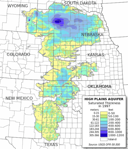
Digital map of the saturated thickness of the High Plains aquifer in parts of Kansas, Nebraska, New Mexico, Oklahoma, South Dakota, Texas, and Wyoming
Several geographers have developed categories to identify climate types. Climate can be defined as a long-term average weather pattern evident in a particular region of the world. Weather is a term usually used to define conditions on a short-term or even daily basis. The two main elements in climate conditions are temperature and precipitation. For the purposes of this overview of world geography, the various climate types have been broken down into six basic types—A, B, C, D, E, and H—after the Köppen-Geiger classification system. Type H climates are actually a subset of the type E climate category.
- Type A: Tropical or equatorial climates
- Type B: Dry or arid climates
- Type C: Moderate or temperate climates
- Type D: Cold or continental climates
- Type E: Polar or extreme climates
- Type H: (Unclassified) highland climates
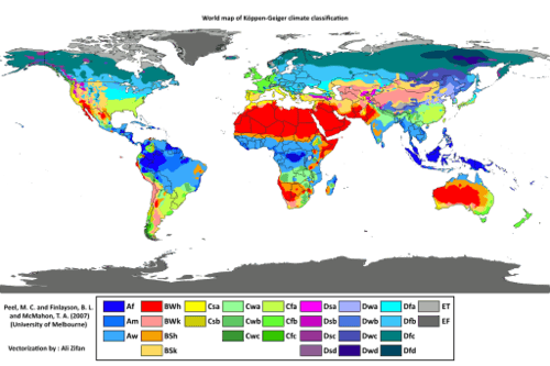 Köppen-Geiger climate classification is one of the most widely used climate classification systems. It was first published by Russian German climatologist Wladimir Köppen in 1884.
Type A: Tropical or Equatorial Climates
The humid tropical type A climate, usually found in the tropics, has warm temperatures year round with a high level of precipitation, typically in the form of rain. Type A climates have various subgroups that indicate how variably the rainfall is distributed throughout the year. Some type A climates produce a dry season and a wet season (monsoon), while others receive consistent rainfall throughout the year.
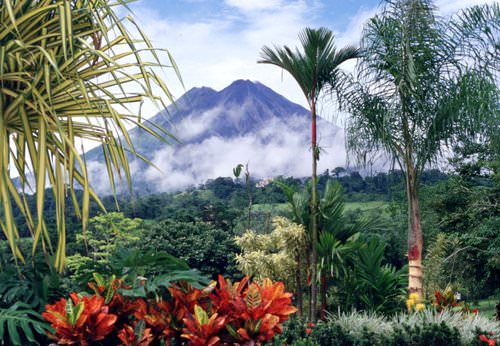
Costa Rica, a country located in Central America, is a type A climate.
Type B: Dry or Arid Climates
The dry type B climate is exemplified by the earth's desert regions. Temperatures can be extreme, with little precipitation. Type B climate regions experience low rainfall and high temperatures during the day and cooler temperatures at night or during the winter season. Terrain in type B climates can range from sand deserts to prairie grasslands or steppes. Type B climates have fewer trees than most other climate areas.
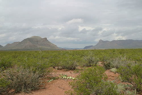
Threemile and Fivemile Mountains near Van Horn, Texas, are in the Chihuahuan Desert. The Chihuahuan Desert is a type B climate.
There is a direct relationship between highlands and type B climates in various places in the world. This climate condition, known as the rain shadow effect, or more accurately, the precipitation shadow effect, occurs when one side of a mountain range receives abundant rainfall while the region on the other side of the mountain range has a more arid climate. This phenomenon is evident wherever there is terrain with enough elevation to restrict the movement of precipitation bearing clouds.
Rain Shadow Effect
Rain shadows are created when prevailing winds carrying moisture rise quickly in elevation up a mountainside, where the air cools and condenses to precipitate out its moisture in the form of rain or snow. By the time the air mass hits the top of the mountain, its moisture is reduced. The dried air rushes down the other side of the mountain range, where it increases in temperature. The warm, dry air coming off the mountains continues to pull moisture out of the land, resulting in arid climate conditions.
The Hawaiian island of Kauai is an example of the rain shadow effect. The island's windward side receives more rain than almost any other place on Earth: as much as 460 inches (almost 40 feet) a year. Only a part of the island, however, receives that amount of rain. The height of the mountains causes a rain shadow on the dry leeward side, creating semi-desert conditions and type B climates.
.jpg?revision=1)
Kauai's origins are volcanic, the island having been formed by the passage of the Pacific Plate over the Hawaii hotspot. At approximately six million years old, it is the oldest of the Hawaiian islands. The highest peak on this mountainous island is Kawaikini at 5,243 feet (1,598 m).
Death Valley in California is also a result of the rain shadow effect. Little rain falls on Death Valley because any moisture in the prevailing winds falls on the western side of the bordering mountain ranges. The whole state of Nevada is dry because of the rain shadow effect. All the rain coming off of the Pacific Ocean falls on the coastal mountains and the Sierra Nevada in California. The mountains are high enough to shadow that region of Nevada, and the basin and ranges further the rain shadow effect on a local basis.
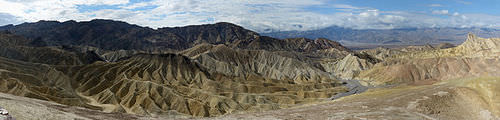
Death Valley is a desert valley located in Eastern California, in the northern Mojave Desert bordering the Great Basin Desert. It is one of the hottest places in the world at the height of summertime.
On the other side of the earth, the Himalayas are an excellent example of mountains that create the rain shadow effect. Most of western China has a type B climate because of the rain shadow effect caused by high mountains that stop precipitation-bearing clouds from ever reaching the region. The southern side of the Himalayas receives extensive rainfall because of monsoon rains arriving from the Indian Ocean, but western China is essentially a desert. It is sparsely inhabited compared with the high-density regions in China Proper to the east, where rainfall is plentiful.
Type C: Moderate or Temperate Climates
Often described as moderate in temperature and precipitation, type C climates are the most favorable to human habitation in that they host the largest human population densities on the planet. Type C climates are found mostly in the mid-latitudes bordering the tropics. Seasonal changes are pronounced, with distinct winters and summers. Winters are cool to cold and summers are usually warm. Precipitation varies from low to high, depending on location. In the United States, C climates dominate the southeast and the West Coast.
Type C climates are not the most widespread on the planet, but they have attracted the largest human populations. One reason for the attraction has been the abundance of forests, farmland, and fresh water found in type C regions. The main population centers of the planet are in type C climates. With over seven billion people on the planet and growing, humans have populated most of the regions with type C climates and are now filling up the other areas that have A, B, or D climate types.
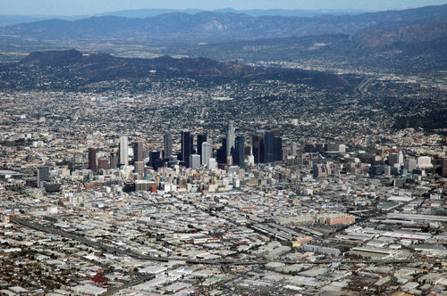 Los Angeles, California, in the United States, is a type C climate.
Type D: Cold or Continental Climates
Type D climate regions are often found in the interiors of continents away from the moderating influence of large bodies of water. They are often farther north than type C regions, resulting in colder winters. Seasonal variations exist, with cool to hot summers and cold winters. Precipitation is usually in the form of rain in summer and snow in winter. Regions with type D climates can be found in the Great Lakes region of the United States, much of Canada, and a large portion of Russia.
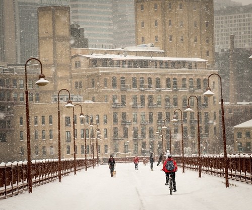
Minneapolis, Minnesota, in the United States, is a type D climate.
Type E: Polar or Extreme Climates
Type E is an extreme climate type found in the Polar Regions near or to the north of the Arctic Circle and near or to the south of the Antarctic Circle. Regions with type E climates are cold with permanent ice or permafrost year round. Vegetation is minimal, and there are no trees. Temperatures may warm slightly during the short summer months; however, they rarely rise above 50 degrees.
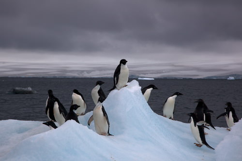
Antarctica is a type E climate.
Type H: Highland Climates
Type H highland climates are usually listed as a subcategory of type E climates. Mountain ranges can create a variety of climate types because of the change in elevation from the base of the range to the summit. Different climate types can be found on the same mountain at different elevations. Type H climates designate highlands or mountain terrain, although variations in climate exist on most mountain ranges. Climates at the base of mountains will vary depending on whether the mountains are found in the tropics or in the higher latitudes.
High mountains near the equator may have a type A climate at their base and a type E climate at their summit with various type C and type D climates between them. Type H climates are found where elevation differences are profound enough to provide different climate zones. Higher elevation relief can reach above the tree line and have permanent snow cover at the summit. The term relief is used in geography to indicate elevations of a land surface. Elevation zones with permanent ice or snow can resemble a type E polar climate.
.jpg?revision=1) The Andes Mountains are located in South America and are a type H climate.
The Andes Mountains are located in South America and are a type H climate.El Nino
El Niño is the warm phase of the El Niño Southern Oscillation (ENSO). This happens when a band of warm ocean water develops in the central and east-central equatorial Pacific, including off the Pacific coast of South America. El Niño refers to the cycle of warm and cold temperatures, as measured by Sea Surface Temperature (SST) of the tropical central and eastern Pacific Ocean. The characteristics of El Niño are high air pressure in the western Pacific and low air pressure in the eastern Pacific.
The cool phase of ENSO, called La Niña, happens when SST in the eastern Pacific is below average. Moreover, air pressure is high in the eastern Pacific and low in the western Pacific. The ENSO cycle of El Niño and La Niña causes global changes in both temperatures and rainfall.
Economies that engage in farming and fishing in the regions impacted by El Niño are especially at risk. However, no matter where you are in the world, El Niño has the potential to affect you, from fires, drought, and flooding, to crop failures, insect explosions, plague and higher prices on goods and services.
Deforestation
The planet's growing population has increased demands on natural resources, including forest products. Humans have been using trees for firewood, building homes, and making tools for millennia. Trees are a renewable resource, but deforestation occurs when they are removed faster than they can be replenished. Most people in rural areas in developing countries rely on firewood to cook their food. Many of these areas are experiencing a fast decline in the number of trees available. People living in mainly type B climates may not have access to a lot of trees to start with; therefore, when trees are cut down for firewood or for building materials, deforestation occurs.
In the tropical areas, it is common for hardwood trees to be cut down for lumber to gain income or to clear the land for other agricultural purposes, such as cattle ranching. Countries that lack opportunities and advantages look to exploit their natural resources—in this case, trees—for either subsistence agriculture or economic gain. Deforestation has increased across the globe with the rapid rise in the worldwide population.
During the Industrial Revolution, European countries chopped down their forests at a rapid rate. Much of the British Isles was forested at one point, but today few forests remain on the British Isles, and they are typically protected. Colonialism brought the Europeans to the Americas. The United States, in its early development, pushed west from the original thirteen colonies, and many old growth forests were cut down in the process. As railroad tracks were laid down and pioneer development pushed west into the Great Plains, where there were few trees, the great cutover occurred in the eastern and central forests.
Cutover is a term indicating the systematic deforestation of the eastern and central forests. Michigan and Wisconsin saw their trees removed in systematic deforestation. Some areas were allowed to grow back, but many other areas were turned into farmland. Few old-growth forests remain in the United States. Today there are conflicts over how the timber industry is handling the forests in places such as the Pacific Northwest region of the United States.
Countries that are better off economically no longer have to cut down their own trees and can afford to substitute other resources or import lumber from other places. Developing regions of the world in Latin America, Africa, and parts of Asia, are experiencing serious problems with deforestation. Deforestation is widespread; for example, citizens of Haiti have cut down about 99 percent of the country's forests and most of the wood has been used as fuel to cook food. People in Afghanistan have cut down about 70 percent of their forests. Nigeria has lost about 80 percent of its old-growth forests since 1990. Ethiopia has lost up to 98 percent of its forested acreage, and the Philippines has lost about 80 percent of its forests.
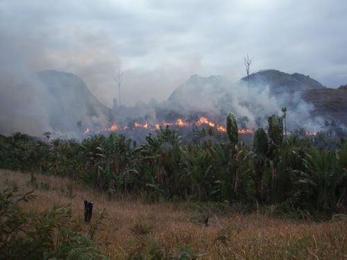
Illegal slash and burn practice in the region west of Manantenina, Madagascar.
Brazil's Amazon basin has undergone many projects that have driven deforestation. For example, about half the state of Rondônia in western Brazil has been deforested since 1990. The countries of Central America have lost about half their original forests, and deforestation continues on a systematic basis. Tropical regions of Southeast Asia and Africa are being exploited for their timber at unsustainable rates. This will have consequences that the next generation will have to resolve.
India, with more than one billion people, has a high demand for firewood and building materials. Their forests are declining faster than they can be replanted. China has been attempting to address its deforestation problems by implementing a massive replanting program and conservation measures. Other countries are starting to adopt similar measures.
Tropical rain forests only make up about five percent of the earth's surface, but contain up to 50 percent of the earth's biodiversity. These forests are cut down for a variety of reasons. Norman Meyers, a British environmentalist, estimated that about five percent of deforestation in tropical regions is caused by the push for cattle production. Nineteen percent of these forests are cut down by the timber industry, 22 percent are cut down for the expansion of plantation agriculture, and 54 percent are removed due to slash-and-burn farming. Most tropical rain forests are located in the Amazon basin of South America, in central Africa, and in Southeast Asia. All these areas are looking for advantages and opportunities to boost their economies. Unfortunately, they often target their tropical rain forests as a way to make money.
What Are the Problems with Deforestation?
Deforestation causes more than the loss of trees for fuel, building materials, paper products, or manufacturing. Another related issue with deforestation is soil erosion. Without the trees to hold the soil during heavy rains, soils are eroded away. In tropical areas, soils are often degraded and lack nutrients. Most of the nutrients in the tropical areas rest in decaying material at the base of the trees that supply energy back into the ecosystem. Once the trees are removed, there is little replenishing of this energy supply. Soil erosion in tropical areas makes it hard for forests to grow back once they have been removed.
Landslides can be a more severe component of the soil erosion problem. After heavy rainfall, entire hillsides saturated with water can slide downward, causing serious structural damage to buildings, homes, and agricultural plots. Tree roots help hold hillsides together and therefore help prevent landslides.
Forests play an important role in the water cycle. Trees pull up moisture with their roots from the soil and transpire it through their leaves back into the atmosphere. Moisture in the atmosphere collects into clouds, condenses, and falls back to Earth. Not only do trees store water, but organic matter at the base of the trees also stores water and makes it available to the larger ecosystem, which may slow down water runoff. Forest canopies disperse water during rainfall and create another layer of moisture in their leaves and branches, which either is used by other organisms or evaporates back into the atmosphere.
Deforestation eliminates the role that forests play in the water cycle. Forest ecosystems provide for a diverse community of organisms. Tropical rain forests are one of the most vibrant ecosystems on the planet. Their abundant biodiversity can provide insight into solutions for the future. Plants and organisms in these habitats may hold the key to medical or biological breakthroughs. Sadly, wildlife and vegetation will be lost as deforestation eliminates their habitat and speeds up the extinction of endangered species.
Trees and plants remove carbon dioxide from the atmosphere and store it in the plant structure through the process of photosynthesis. Carbon dioxide is a major greenhouse gas that is a part of the climate change process. Carbon dioxide and other similar gases reduce the amount of heat that escapes from the earth's atmosphere, resulting in increased temperatures on the planet. As more carbon dioxide is emitted into the atmosphere, climate change occurs. The removal of trees through deforestation results in less carbon dioxide being removed from the atmosphere, which contributes to climate change.
Climate Change
Climate change has been a constant activity in Earth's evolution. The increase in temperature in our environment is the activity that has gained the most attention in recent years. Questions have been raised about the rate and extent of climate change around the world. Understanding the dynamics of the temperature increase can help us to understand how it is related to human activity.
The atmosphere is the gaseous layer that surrounds the earth and marks the transition between its surface and space. The atmosphere consists of a mixture of gases, composed of nitrogen (77 percent), oxygen (21 percent), and minor elements (1 percent) including argon, helium, carbon dioxide, and water vapor. The small amount of carbon dioxide is a critical component in the control of the earth's temperature. The atmosphere extends over three hundred miles above the earth's surface, and the lower level makes up the earth's climatic system. This lowest level is called the troposphere and is responsible for the conditions that allow life to exist on the planet's surface.
Since the 1960s, scientists have been concerned about the concentrations of carbon dioxide, methane, nitrous oxide, and chlorofluorocarbons in the atmosphere. These so-called greenhouse gases can trap heat energy emitted from the earth's surface and may increase global temperatures and cause climate change. Since the Industrial Revolution, human activity—the burning of fossil fuels and large-scale deforestation—has increased the amount of heat-trapping greenhouse gases in the atmosphere. Carbon dioxide and similar gases act like the glass panels of a greenhouse that allow shortwave radiation from the sun to enter but do not allow the long-wave radiation of heat to escape into space.
An increase in carbon dioxide and greenhouse gases in the atmosphere will normally cause an increase in the temperature of the planet's climate, which in turn may cause changes in weather conditions on Earth. Temperature changes may affect precipitation patterns and alter weather patterns. This may affect agricultural outputs and influence energy needs that can create increasing economic instability. Changes in climate also impact environmental conditions for organisms adapted to specific habitat ranges. When climates change, an organism's habitable zone may also change, which in turn can impact entire ecosystems.
Burning of fossil fuels can also contribute to climate change. Fossil fuels such as coal, oil, and natural gas are created when dead plant and animal life are under pressure, decay for long periods, and retain their carbon component. Burning fossil fuels releases the carbon back into the atmosphere. The increasing need for energy by human activity will continue to contribute to climate change unless alternatives can be found. The increase in temperatures may result in the melting of the ice caps, which in turn may raise sea levels, impacting human activity around the world.
Tectonic Plates
The movement of tectonic plates is another aspect of the earth's dynamics that affects human activity. The earth's crust, which is between 10 and 125 miles thick, is a series of plates that cover a molten iron core at the center of the planet. The plates that cover the earth's surface slowly shift and move. Plates can slide away from each other or they can collide, and they can slide parallel to each other in opposite directions. When two plates collide and one plate slides under an adjacent plate, the process is called subduction. Movement or shift where two plates meet can cause earthquakes and is usually associated with volcanic activity.
Mountain chains, such as the Himalayas, are a result of two plates colliding. The collision pushes up the earth into a mountain chain, either by direct pressure or by volcanic activity. Plates can move up to an inch a year in active regions. Driven by the earth's internal heat, these plates have created the planet's mountain landscapes. Earthquakes and volcanic action along plate boundaries (called faults) continue to affect human activity and can cause serious economic damage to a community. Plate boundaries can be found near many natural edges of continents.
The continuous action of the plates causes serious earthquakes and volcanic eruptions that can devastate the daily activities of people. Earthquakes near the sea often trigger tsunamis, waves that bring destruction to coastal regions in their path. The earthquake off the east coast of Japan in 2011 created a tsunami that brought additional destruction to nuclear energy facilities, exposing parts of Japan and the rest of the world to radiation.
- Human activity on the planet correlates with the type of climate and terrain that presents itself to humans in the form of natural resources or habitability.
- Six basic climate zones (A, B, C, D, E, and H) describe the earth's climate types.
- Temperature and precipitation are the two main variables that create a climate zone and its corresponding environmental attributes.
- The earth's crust consists of a number of separate plates that move, creating earthquakes and volcanic activity.
- Most mountain ranges on Earth are a product of tectonic plate activity.
- Removing trees faster than they can grow back is called deforestation.
- Humans are cutting down the forests in many areas at an unsustainable rate.
- Deforestation can result in soil erosion, changes in weather patterns, and the loss of habitats.
- Trees are being cut down for firewood, building materials, or profit.
- Mountains or high elevation relief can restrict the passage of rain clouds and cause the clouds to lose their precipitation as the air mass increases in elevation creating a rain shadow effect.
- The other side of the mountain or range does not receive any precipitation and is reduced to a more arid or drier region, creating desert conditions.
- Climate change is a phenomenon whereby gases such as carbon dioxide and methane increase in the troposphere and restrict long-wave radiation from escaping the planet, which can result in warmer temperatures on Earth.
- Trees remove carbon dioxide from the atmosphere, which may reduce climate change.
Vocabulary Terms
| biome | A large ecosystem characterized by common climate, common vegetation, and common animal life |
| El Nino | A warm ocean current the flows off the west coast of South America every few years. An El Nino event changes weather patterns around the world and may cause extreme weather in some regions |
| crop rotation | The practice of rotating use of different fields from crop to crop each year to avoid exhausting the soil |
| deforestation | Removing of or clearing away the trees from a forest often done to clear land for farming and ranching |
| fault | A line on Earth’s surface the results from a deep crack in the crust |
| fossil water | Water that has been contained in some undisturbed space, in an aquifer, for millennia |
| global warming | Gradual warming of Earth's surface caused by the accumulation of greenhouse gasses in the atmosphere |
| groundwater | Water lying deep under the ground that supplies wells and springs |
| irrigation | The supply of water to land or crops to help growth, typically by means of channels. This allows dry areas to support crops |
| La Nina | A cooling of the water in the equatorial Pacific that occurs at irregular intervals and is associated with widespread changes in weather patterns complementary to those of El Niño, but less extensive and damaging in their effects |
| over-farming | Planting the same crops every year causing the degradation of nutrients in the soil and yielding fewer crops |
| plate-tectonics | A large piece of Earths crusts that floats on the liquid mantle |
| permafrost | A layer of soil beneath the earth's surface that is always frozen |
| rain shadow effect | The land on the leeward side of hills or mountains that gets little rain from the descending dry air |
| renewable energy | Energy from a source that is not depleted when used, such as wind or solar power |
| smog | A haze in the air caused by air pollution, especially the exhaust from cars and other vehicles |
| subduction | The sideways and downward movement of the edge of a plate of the earth's crust into the mantle beneath another plate |
| tsunami | A huge, destructive wave caused by the displacement of a large volume of a body of water, typically by an earthquake or volcanic eruption |
| watershed | An area of land that is drained by a river and its tributaries |
| zones of latitude | The three main latitude regions of the Earth's surface comprise geographical zones, divided by the major circles of latitude. The differences between them relate to climate. Low latitudes, tropical; middle latitudes, temperate; high latitudes, polar |
Applying Knowledge
Interactive Notebook Activities
- Explain how climate and human habitation are related and distinguish the main climate types.
- Describe the dynamics of tectonic plates and their relationship to earthquakes and volcanic activity.
- Outline the main causes of deforestation. Explain the relationship between deforestation and climate change.
- Describe where the rain shadow effect takes place. Explain why it occurs in those places and how it may influence human activity.
- Summarize how climate change occurs and the relationship between greenhouse gases such as carbon dioxide and the planet's temperature regulation.
Discussion and Study Questions
- What climate type do you live in?
- What are the main attributes of each climate type?
- What two main climatic qualities do humans gravitate toward?
- What is the difference between weather and climate?
- How can the main causes of deforestation be alleviated or diminished?
- What are tectonic plates, and how do they help shape the planet?
- How does tectonic plate movement affect human activities?
- Who is responsible for addressing the problems caused by climate change? What can you do about it?
- What causes a rain shadow effect? Name some examples of this phenomenon.
- Which regions of the planet are being affected the most by deforestation?
Tech Activities
- Research and determine when the last three earthquakes nearest where you live occurred. What damage did they cause?
- Chart the annual average temperature for where you live for the past one hundred years to illustrate any trend in climate change.
- Using the Internet, determine the nearest location to where you live that is impacted by a rain shadow effect.
Mapping Exercise
The Earth Moves Module 2 Lesson 1: In this activity, students will observe worldwide patterns of seismic activity (earthquakes) and volcanic activity (volcanoes). Students will analyze the relationships of those patterns to tectonic plate boundaries and major physical features of the earth’s surface. Then students will identify cities at risk.
Videos for Geography Enrichment
Helpful Websites for the Study of Geography
Canadian Encyclopedia is an encyclopedia funded by the Canadian government covering all branches of knowledge. Their scholarly collection includes interactive materials.
CIA World Factbook provides information on the people, history, government, economy, energy, geography, communications, transportation, military, and transnational issues for the world's entities.
Congress.gov is a US government website where you can find federal legislation, past and present, as well as information about the US legal system.
Drug Enforcement Administration (DEA) is a government agency website that provides current news, resources, topics of interest, information about drugs, careers in the DEA, and a tip hotline.
Library of Congress is the largest library in the world and provides manuscripts, files, information, pictures, and videos.
NASA Earth Observatory (NEO) is a US government agency website that allows users to search for and retrieve satellite images of Earth.
National Archives is a US government website that provides historical documents, photos, records, publications, and educator resources.
National Oceanic and Atmospheric Association (NOAA) is a US government agency website that provides weather-related information and ocean research.
National Map is a website by the United States Geological Survey and other federal, state, and local agencies that deliver topographic information for the United States.
NationMaster is a massive central data source and a handy way to graphically compare nations.
Real-Time World Air Quality Index is a website that measures most locations in the world for air pollution in real time.
StateMaster is a unique statistical database, which allows you to research and compare a multitude of different data on US states.
United Nations (UN) is an international organization founded in 1945 and made up of 193 member states. The UN maintains international peace and security, protects human rights, delivers humanitarian aid, promotes sustainable development, and upholds international law.
United States Census Bureau is a US government agency that provides a population clock, data, surveys, statistics, a library with information and infographics, news about the economy, and much more.
United States Geological Survey (USGS) is a US government agency website that provides scientific information about the natural hazards that threaten lives, the natural resources we rely on, the health of our ecosystems and environment, and the impacts of climate and land-use change.
Whitehouse.gov is a US government website that provides the latest presidential news, information about the budget, policy, defense, and many more topics.
World Health Organization (WHO) is under the United Nations and provides leadership on matters critical to health, shapes the research agenda on health, and monitors the health situation and assessing health trends around the world. Their website provides information on the state of health around the world, outbreaks, current health news, and more.
World Trade Organization (WTO) is an intergovernmental organization that regulates international trade. The website provides information on the history of the multilateral trading system, featured videos, news and events, trade topics, and more.
| Image | Reference | Attributions |
|
[Figure 1] | Credit: By Kbh3rd (Own work) [CC BY-SA 3.0 (https://creativecommons.org/licenses/by-sa/3.0) or GFDL (http://www.gnu.org/copyleft/fdl.html)], via Wikimedia Commons Source: https://commons.wikimedia.org/wiki/File%3AOgallala_saturated_thickness_1997-sattk97.svg License: CC BY-NC 3.0 |
|
[Figure 3] | Credit: By Arturo Sotillo from La Canada, CA, USA (Costa Rica... No artificial ingredients!) [CC BY-SA 2.0 (https://creativecommons.org/licenses/by-sa/2.0)], via Wikimedia Commons Source: https://commons.wikimedia.org/wiki/File%3ACosta_Rica..._No_artificial_ingredients!_(673029449).jpg License: CC BY-NC 3.0 |
|
[Figure 4] | Credit: By Leaflet (Own work) [CC BY-SA 3.0 (https://creativecommons.org/licenses/by-sa/3.0)], via Wikimedia Commons Source: https://commons.wikimedia.org/wiki/File%3AVanHornTX_2008.jpg License: CC BY-NC 3.0 |
|
[Figure 6] | Credit: By This Photo was taken by Wolfgang Moroder. Feel free to use my photos, but please mention me as the author and send me a message. This image is not public domain. Please respect the copyright protection. It may only be used according to the rules mentioned here. This specifically excludes use in social media, if applicable terms of the licenses listed here not appropriate. Please do not upload an updated image here without consultation with the Author. The author would like to make corrections only at his own source. This ensures that the changes are preserved. Please if you think that any changes should be required, please inform the author. Otherwise you can upload a new image with a new name. Please use one of the templates derivative or extract. (Own work) [CC BY-SA 3.0 (https://creativecommons.org/licenses/by-sa/3.0)], via Wikimedia Commons Source: https://commons.wikimedia.org/wiki/File%3AZbriskie_Point_South_Panorama_2012.jpg License: CC BY-NC 3.0 |
|
[Figure 8] | Credit: Pixabay Source: pixabay.com/en/minneapolis-winter-bridge-downtown-2347321/ License: CC BY-NC 3.0 |
|
[Figure 9] | Credit: By Jason Auch (originally posted to Flickr as IMG_0760) [CC BY 2.0 (http://creativecommons.org/licenses/by/2.0)], via Wikimedia Commons Source: https://commons.wikimedia.org/wiki/File%3AAdelie_Penguins_on_iceberg.jpg License: CC BY-NC 3.0 |
|
[Figure 11] | Credit: By Diorit (Own work) [CC BY-SA 3.0 (https://creativecommons.org/licenses/by-sa/3.0) or GFDL (http://www.gnu.org/copyleft/fdl.html)], via Wikimedia Commons Source: https://commons.wikimedia.org/wiki/File%3AManantenina_bushfire.jpg License: CC BY-NC 3.0 |