
4.5: South America- Physical Geography (1 Day)
- Page ID
- 1963
\( \newcommand{\vecs}[1]{\overset { \scriptstyle \rightharpoonup} {\mathbf{#1}} } \)
\( \newcommand{\vecd}[1]{\overset{-\!-\!\rightharpoonup}{\vphantom{a}\smash {#1}}} \)
\( \newcommand{\dsum}{\displaystyle\sum\limits} \)
\( \newcommand{\dint}{\displaystyle\int\limits} \)
\( \newcommand{\dlim}{\displaystyle\lim\limits} \)
\( \newcommand{\id}{\mathrm{id}}\) \( \newcommand{\Span}{\mathrm{span}}\)
( \newcommand{\kernel}{\mathrm{null}\,}\) \( \newcommand{\range}{\mathrm{range}\,}\)
\( \newcommand{\RealPart}{\mathrm{Re}}\) \( \newcommand{\ImaginaryPart}{\mathrm{Im}}\)
\( \newcommand{\Argument}{\mathrm{Arg}}\) \( \newcommand{\norm}[1]{\| #1 \|}\)
\( \newcommand{\inner}[2]{\langle #1, #2 \rangle}\)
\( \newcommand{\Span}{\mathrm{span}}\)
\( \newcommand{\id}{\mathrm{id}}\)
\( \newcommand{\Span}{\mathrm{span}}\)
\( \newcommand{\kernel}{\mathrm{null}\,}\)
\( \newcommand{\range}{\mathrm{range}\,}\)
\( \newcommand{\RealPart}{\mathrm{Re}}\)
\( \newcommand{\ImaginaryPart}{\mathrm{Im}}\)
\( \newcommand{\Argument}{\mathrm{Arg}}\)
\( \newcommand{\norm}[1]{\| #1 \|}\)
\( \newcommand{\inner}[2]{\langle #1, #2 \rangle}\)
\( \newcommand{\Span}{\mathrm{span}}\) \( \newcommand{\AA}{\unicode[.8,0]{x212B}}\)
\( \newcommand{\vectorA}[1]{\vec{#1}} % arrow\)
\( \newcommand{\vectorAt}[1]{\vec{\text{#1}}} % arrow\)
\( \newcommand{\vectorB}[1]{\overset { \scriptstyle \rightharpoonup} {\mathbf{#1}} } \)
\( \newcommand{\vectorC}[1]{\textbf{#1}} \)
\( \newcommand{\vectorD}[1]{\overrightarrow{#1}} \)
\( \newcommand{\vectorDt}[1]{\overrightarrow{\text{#1}}} \)
\( \newcommand{\vectE}[1]{\overset{-\!-\!\rightharpoonup}{\vphantom{a}\smash{\mathbf {#1}}}} \)
\( \newcommand{\vecs}[1]{\overset { \scriptstyle \rightharpoonup} {\mathbf{#1}} } \)
\(\newcommand{\longvect}{\overrightarrow}\)
\( \newcommand{\vecd}[1]{\overset{-\!-\!\rightharpoonup}{\vphantom{a}\smash {#1}}} \)
\(\newcommand{\avec}{\mathbf a}\) \(\newcommand{\bvec}{\mathbf b}\) \(\newcommand{\cvec}{\mathbf c}\) \(\newcommand{\dvec}{\mathbf d}\) \(\newcommand{\dtil}{\widetilde{\mathbf d}}\) \(\newcommand{\evec}{\mathbf e}\) \(\newcommand{\fvec}{\mathbf f}\) \(\newcommand{\nvec}{\mathbf n}\) \(\newcommand{\pvec}{\mathbf p}\) \(\newcommand{\qvec}{\mathbf q}\) \(\newcommand{\svec}{\mathbf s}\) \(\newcommand{\tvec}{\mathbf t}\) \(\newcommand{\uvec}{\mathbf u}\) \(\newcommand{\vvec}{\mathbf v}\) \(\newcommand{\wvec}{\mathbf w}\) \(\newcommand{\xvec}{\mathbf x}\) \(\newcommand{\yvec}{\mathbf y}\) \(\newcommand{\zvec}{\mathbf z}\) \(\newcommand{\rvec}{\mathbf r}\) \(\newcommand{\mvec}{\mathbf m}\) \(\newcommand{\zerovec}{\mathbf 0}\) \(\newcommand{\onevec}{\mathbf 1}\) \(\newcommand{\real}{\mathbb R}\) \(\newcommand{\twovec}[2]{\left[\begin{array}{r}#1 \\ #2 \end{array}\right]}\) \(\newcommand{\ctwovec}[2]{\left[\begin{array}{c}#1 \\ #2 \end{array}\right]}\) \(\newcommand{\threevec}[3]{\left[\begin{array}{r}#1 \\ #2 \\ #3 \end{array}\right]}\) \(\newcommand{\cthreevec}[3]{\left[\begin{array}{c}#1 \\ #2 \\ #3 \end{array}\right]}\) \(\newcommand{\fourvec}[4]{\left[\begin{array}{r}#1 \\ #2 \\ #3 \\ #4 \end{array}\right]}\) \(\newcommand{\cfourvec}[4]{\left[\begin{array}{c}#1 \\ #2 \\ #3 \\ #4 \end{array}\right]}\) \(\newcommand{\fivevec}[5]{\left[\begin{array}{r}#1 \\ #2 \\ #3 \\ #4 \\ #5 \\ \end{array}\right]}\) \(\newcommand{\cfivevec}[5]{\left[\begin{array}{c}#1 \\ #2 \\ #3 \\ #4 \\ #5 \\ \end{array}\right]}\) \(\newcommand{\mattwo}[4]{\left[\begin{array}{rr}#1 \amp #2 \\ #3 \amp #4 \\ \end{array}\right]}\) \(\newcommand{\laspan}[1]{\text{Span}\{#1\}}\) \(\newcommand{\bcal}{\cal B}\) \(\newcommand{\ccal}{\cal C}\) \(\newcommand{\scal}{\cal S}\) \(\newcommand{\wcal}{\cal W}\) \(\newcommand{\ecal}{\cal E}\) \(\newcommand{\coords}[2]{\left\{#1\right\}_{#2}}\) \(\newcommand{\gray}[1]{\color{gray}{#1}}\) \(\newcommand{\lgray}[1]{\color{lightgray}{#1}}\) \(\newcommand{\rank}{\operatorname{rank}}\) \(\newcommand{\row}{\text{Row}}\) \(\newcommand{\col}{\text{Col}}\) \(\renewcommand{\row}{\text{Row}}\) \(\newcommand{\nul}{\text{Nul}}\) \(\newcommand{\var}{\text{Var}}\) \(\newcommand{\corr}{\text{corr}}\) \(\newcommand{\len}[1]{\left|#1\right|}\) \(\newcommand{\bbar}{\overline{\bvec}}\) \(\newcommand{\bhat}{\widehat{\bvec}}\) \(\newcommand{\bperp}{\bvec^\perp}\) \(\newcommand{\xhat}{\widehat{\xvec}}\) \(\newcommand{\vhat}{\widehat{\vvec}}\) \(\newcommand{\uhat}{\widehat{\uvec}}\) \(\newcommand{\what}{\widehat{\wvec}}\) \(\newcommand{\Sighat}{\widehat{\Sigma}}\) \(\newcommand{\lt}{<}\) \(\newcommand{\gt}{>}\) \(\newcommand{\amp}{&}\) \(\definecolor{fillinmathshade}{gray}{0.9}\)- Summarize briefly the main physical features and characteristics of South America.
- Explain how European colonialism dominated the realm and divided up the continent.
- Describe the ethnic, economic, and political patterns in the Guianas.
- List the main cultural realms of South America.
- Describe each realm’s main ethnic majority.
- Explain how colonialism impacted each region.
- Summarize briefly how the South American countries are attempting to integrate their economies.
TEKS Regional Unit 04: Chapter 4.5 South America: Physical Geography
WG.1B Trace the spatial diffusion of phenomena such as the Columbian Exchange or the diffusion of American popular culture and describe the effects on regions of contact
WG.2A Describe the human and physical characteristics of the same regions at different periods of time to evaluate relationships between past events and current conditions.
WG.4A Explain how elevation, latitude, wind systems, ocean currents, position on a continent, and mountain barriers influence temperature, precipitation, and distribution of climate regions.
WG.4C Explain the influence of climate on the distribution of biomes in different regions.
WG.5A Analyze how the character of a place is related to its political, economic, social, and cultural elements.
WG.7D Examine benefits and challenges of globalization, including connectivity, standard of living, pandemics, and loss of local culture.
WG.9A Identify physical and/or human factors such as climate, vegetation, language, trade networks, political units, river systems, and religion that constitute a region.
WG.9B Describe different types of regions, including formal, functional, and perceptual regions.
WG.14C Analyze current events to infer the physical and human processes that lead to the formation of boundaries and other political divisions.
WG.12A Analyze how the creation, distribution, and management of key natural resources affects the location and patterns of movement of products, money, and people.
WG.17C Compare economic, political, or social opportunities in different cultures for women, ethnic and religious minorities, and other underrepresented populations.
WG.18A Analyze cultural changes in specific regions caused by migration, war, trade, innovations, and diffusion.
WG.18C Identify examples of cultures that maintain traditional ways, including traditional economies.
WG.19A Evaluate the significance of major technological innovations in the areas of transportation and energy that have been used to modify the physical environment.
WG.21C Create and interpret different types of maps to answer geographic questions, infer relationships, and analyze change.
WG.23B Use case studies and GIS to identify contemporary challenges and to answer real-world questions.
WG,22A Design and draw appropriate graphics such as maps, diagrams, tables, and graphs to communicate geographic features, distributions, and relationships.
WG.22C Use geographic terminology correctly.
WG.22D Use standard grammar, spelling, sentence structure, and punctuation.
TEKS and ELPS for Regional World Geography Unit 04--Latin America from TEKS Resource System
South America: Physical Geography
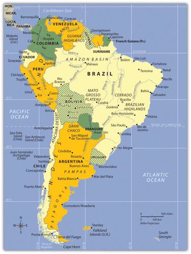 The main two physical features of South America are the Andes Mountains and the Amazon River.
Physical Characteristics
The continent of South America has a wide diversity of physical landscapes, from the high Andes Mountains to the tropical forests of the Amazon Basin. This assortment of physical features offers many resource bases. These resource bases allow people to engage in economic activity, gain wealth, and provide for their needs. The mountain range of the Andes holds mineral riches that have been being extracted since ancient times.
Fossil fuels have been found in abundance in the far northern regions of Venezuela and Colombia. The Amazon Basin has been a source of hardwood lumber and, more recently, extensive mineral wealth. Some of the largest iron-ore mines in the world are located here. The massive plains of Brazil and the rich soils of the Pampas allow for agricultural operations that provide food products for the continent and for the world.
Even the inhospitable Atacama region in northern Chile holds some of the world’s largest copper reserves. The wide variety of climate zones allows a diverse range of species to develop. The extremes in physical geography in South America have created both barriers and opportunities to those who live there.
Before the era of European colonialism, many local groups organized themselves into states or empires. The Inca Empire was the largest in existence at the time the Europeans arrived. The early empires developed massive structures that required huge cut stones weighing many tons to be moved into place without the benefit of modern tools or technology. European colonialism altered the continent in several ways. The Europeans defeated and conquered Amerindian groups such as the Inca.
Cultural exchanges also took place that altered the way of life for countless South Americans. Colonialism created many of the current country borders and influenced trade relationships with the newly created colonies. The plantation system and the introduction of slaves from Africa drastically changed the ethnic makeup of the people living along the eastern coast. After slavery was abolished, indentured servitude brought workers from Asia to support the labor base.
Indentured servants were usually poor individuals who agreed to work for an agreed upon period of time, usually less than seven years, in return for the necessities of life such as lodging, food, and transportation or clothing. These individuals did not usually receive a salary but may have received a lump sum payment upon completion of the agreed upon service. Under favorable conditions indentured servants were treated like relatives and gained important experience and job skills to provide for their future. On the other hand, many died of disease and harsh conditions.
The physical environment and the influence of colonialism were both responsible for the cultural attributes of the regions of South America. The continent can be divided into regions by ethnic majorities influenced by early colonial development. The mixing of ethnic groups from Europe, Africa, and Asia with each other or with the indigenous population has created a diverse cultural mosaic.
For example, most people in Guyana and Suriname are from Asia, most people in Argentina and Uruguay are from Europe, most people in Peru and Bolivia are Amerindian, and most people in many areas along the eastern coast of Brazil are of African descent. A large percentage of the population of South America is of a mixed ethnic background. Understanding the cultural geography of South American supports understanding of the realm’s human development patterns.
South America’s modern economic development has helped integrate it with the global economy. The levels of economic development vary widely within the realm. There are clear indications of core-peripheral spatial patterns within various regions of the continent, and rural-to-urban shift has been strong in many areas. The rural regions in the Andes or the interior suffer from a lack of economic support needed to modernize their infrastructure.
At the same time, metropolitan areas are expanding rapidly and are integrated with global markets and the latest technologies. Most of the large cities are located along the coastal regions. This pattern of urbanization is mainly a result of colonial activity and influence. The countries of South America are working among themselves to network trade and commerce activities. Trade agreements and economic unions have become standard methods of securing business partnerships to enhance the realm’s economic opportunities.
Physical Geography
The far-reaching Andes Mountains and the massive Amazon River system dominate South America’s physical geography. The 5,000-mile-long Andes Mountain chain extends along the entire western region of the continent from Venezuela to southern Chile. The Andes are the longest mountain chain on Earth and the highest in the Americas. The Andes Mountain range has more than 30 peaks that reach at least 20,000 feet in elevation, many of which are active volcanoes.
The Andes has provided isolation to the Inca Empire, mineral wealth to those with the means for extraction, and a barrier to travelers crossing the continent. The Andes’ minerals include gold, silver, tin, and other precious metals. Mining became a major industry in the colonial era and continues to the present.
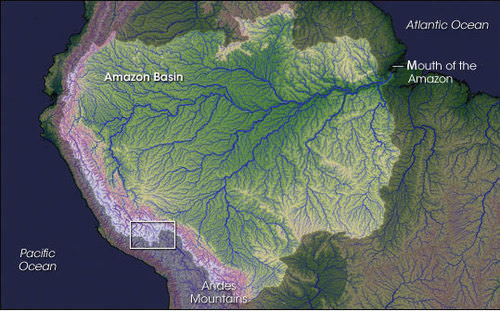
At the core of the continent is the mighty Amazon River, which is more than 2,000 miles long and has an enormous drainage basin in the largest tropical rain forest in the world. The Amazon’s many tributaries are larger than many other world rivers. Flowing parallel to the equator, the Amazon rivals the Nile as the longest river in the world. The Amazon River has the greatest discharge of any river in the world. It carries about one-fifth of all river water in the world.
The Amazon and its many tributaries drain the entire interior region of the continent, covering 40 percent of South America. During the rainy season, it can be more than 100 miles wide. No bridges span the Amazon River. Its source is a glacial stream located high in the Peruvian Andes, about 150 miles from the Pacific Ocean.
The Amazon’s extended tributaries—such as the Rio Negro, the Madeira, and the Xingu—move massive amounts of water through the Amazon Basin and are major rivers in their own right. The Amazon has more than 1,100 tributaries; a dozen are more than 1,000 miles long. Hydroelectric dams are located on the tributaries to produce electricity for the region’s fast-growing development.
South America has additional large rivers that drain the continent, including the Orinoco, which flows through Venezuela; the Sao Francisco, which flows through southeast Brazil; and the Paraguay and the Paraná Rivers, which flow south from Brazil into the Rio de la Plata between Argentina and Uruguay.
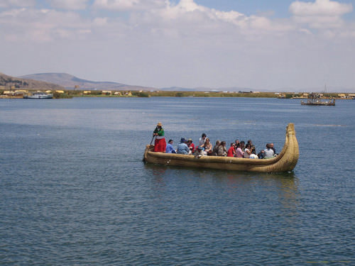
The Altiplano Region is a wide basin between two main Andean mountain ranges. The word altiplano means “valley” in Spanish. There are a substantial number of altiplanos in South America. They provide for agricultural production and human habitation. The Altiplano Region has been home to ancient civilizations that date back to early human settlements.
Lake Titicaca rests in the middle of the Altiplano Region of the Central Andes on the border between Peru and Bolivia. Lake Titicaca is a large freshwater lake about 120 miles long and 50 miles wide. The surface is at an elevation of about 12,000 feet above sea level. The lake is more than 900 feet deep in some areas. Usually at such high elevations, the temperature would dip below freezing and restrict agriculture. However, the large lake acts as a solar energy collector by absorbing energy from the sun during the day and giving off that energy in the form of heat during the night. The energy redistribution allows for a moderate temperature around the lake that is beneficial to growing food crops.
With abundant fresh water and the ability to grow food and catch fish, the Altiplano Region has supported human habitation for thousands of years. On the Bolivian side of the lake is the ancient stone site of Tiahuanaco, which has had some artifacts dated to 1500 B.C.E. or earlier. People continue to live around and on Lake Titicaca and maintain a subsistence lifestyle.
 Lake Titicaca is the highest-elevation navigable lake in the world.
Across the Andes Mountains from the Altiplano Region is the Atacama Desert. The Atacama is one of the driest places on Earth. In some parts, no rain has fallen in recorded history. Under normal circumstances, the Atacama would be a desolate region without human activity, but that is not the case. Some of the world’s largest copper reserves are found here. Nitrates, which are used in fertilizers, are also found in large quantities. Mining the Atacama has brought enormous wealth to many people.
The rain shadow effect is responsible for the extraordinary dryness of the Atacama. The Andes are quite high at this latitude, and the winds blow in rain clouds from the east. When the clouds reach the mountains, they ascend in elevation, releasing their precipitation without ever reaching the western side of the Andes.
South America has large agricultural plateaus east of the Andes, such as the Mato Grosso Plateau. It includes a portion of the great Cerrado agricultural region of central Brazil. The Cerrado is a vast plain that has been developed for agriculture and produces enormous harvests of soybeans and grain crops. Bordering the Cerrado to the southeast are the Brazilian Highlands, an extensive coffee-growing region. The Pampas in eastern Argentina, Uruguay, and southernmost Brazil is another excellent agricultural region with good soils and adequate rainfall. Farming, cattle ranching, and even vineyards can be found here, making the Pampas the breadbasket of the Southern Cone.
To the south of the Pampas is the lengthy expanse of Patagonia, which covers the southern portion of Argentina east of the Andes. Patagonia is a prairie grassland region that does not receive much rainfall because of the rain shadow effect of the Andes to the west. The main activities in Patagonia are the raising of cattle and other livestock. The region is starting to attract attention to the extraction of natural resources such as oil, natural gas, and valuable minerals.
To the northern part of the continent in Venezuela and Colombia, sandwiched between the Andes Mountains and the Guiana Highlands, is a grassland region with scrub forests called the Llanos. The human population is small because of the remoteness of the region along the Orinoco River basin. The Guiana Highlands of southeast Venezuela and the Guianas are an isolated set of mountainous plateaus mixed with rugged landscapes and tropical climates. Angel Falls, the highest waterfall in the world, with a free fall of more than 2,647 feet and a total drop of about 3,212 feet (more than half a mile), is located here. To the northwest of the Llanos and the Guiana Highlands in Venezuela is Lake Maracaibo, a large inland lake open to the Caribbean Sea. A coastal lake, Maracaibo rests atop vast oil reserves that provide economic wealth for Venezuela.
European Colonialism
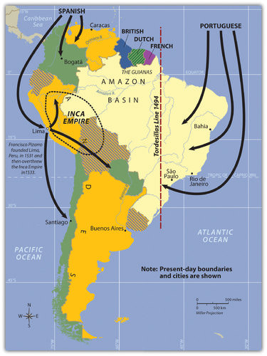
South America’s colonial legacy shaped its early cultural landscape. The indigenous people, with their empires and local groups, were no match for the European colonizers. South America was colonized exclusively by two main Iberian powers: Spain colonized the western part of South America, and Portugal colonized the east coast of what is present-day Brazil. The only region that was not colonized by those two powers was the small region of the Guianas, which was colonized by Great Britain, the Netherlands, and France.
 Colonial Activity in South America
Everything changed with the invasion of the Iberian colonizers. The culture, religion, and economics of the local indigenous people were disrupted and forced to change. The Spanish and Portuguese languages, as well as the Roman Catholic religion, superseded the languages and religions that had previously existed.
Colonialism also was responsible for transporting food crops such as the potato, which originated in the Peruvian Andes, to the Europeans. Today, coffee is a main export of Colombia, Brazil and other countries in the tropics. Coffee was not native to South America but originated in Ethiopia and was transferred by colonial activity. The same is true of sugarcane, bananas, and citrus fruits. Oranges were not native to South America, but today Brazil is the number one exporter of orange juice. Colonialism was driven by the desire for profit from the quick sale of products such as gold or silver. There was a ready market for goods not found in Europe, such as tobacco, corn, exotic animals, and tropical woods.
Plantation agriculture introduced by the Europeans led to a high demand for manual laborers. When the local populations could not meet the labor demand, millions of Africans were brought through the slave trade. These African slaves introduced their own unique customs and traditions, altering the culture and demographics of the Western Hemisphere. The current indigenous Amerindian population, a fraction of what it was before the Europeans arrived, makes up only a small percentage of South America’s total population. Europeans took the best land and controlled the economic trade of the region. The acculturation in South America is directly related to the European colonial experience.
The Inca Empire and Francisco Pizarro
Not long after Hernán Cortés conquered the Aztec Empire of Mexico in 1521, a young Spanish conquistador named Francisco Pizarro, stationed in what is now Panama, heard rumors of silver and gold found among the South American people. He led several sailing excursions along the west coast of South America. In 1531 C.E., he founded the port city of Lima, Peru.
Since 1200 C.E., the Inca had ruled a large empire extending out from central Peru, which included the high-elevation Altiplano Region around Lake Titicaca. The Inca Empire dominated an area from Ecuador to Northern Chile. The Inca were not the most populous people but were a ruling class who controlled other subjugated groups.
Pizarro, with fewer than 200 men and 24 horses, met up with the Inca armies and managed to defeat them in a series of military maneuvers. The Inca leader was captured by the Spanish in 1533. Two years later, in 1535, the Inca Empire collapsed.
The Inca Empire was important to European conquerors because of the high volume of gold and silver found in the Andes. The story is told that Pizarro placed the captured Inca leader in a small room and told him that if the room was filled with gold to the top of the Inca leader’s head, Pizarro would let the Inca leader go free. Gold was summoned from the people and the countryside, and the room was filled.
The conquistadors forced the Inca leader to convert to Catholicism and then killed him. The gold was melted down and transported back to Spain. The mineral wealth of the Andes made the conquistadors rich. Lima was once one of the wealthiest cities in the world. Europeans continued to dominate and exploit the mining of minerals in Peru and Bolivia throughout the colonial era. European elites and the Mestizo ruling class have subjugated the Amerindian groups in the Andes since colonial times.
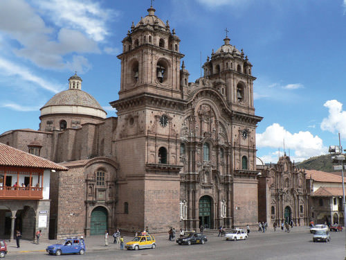 The original church was constructed in 1571 on the site of the ancient Incan palace. The earthquake of 1650 caused severe damage to the building, so it had to be reconstructed in about 1688. Many Catholic cathedrals in Latin America were built with stones from ancient sites. This cathedral is claimed to be the Western Hemisphere’s most ideal example of colonial baroque architecture.
Many Amerindian groups inhabited this region before the Inca Empire, such as the people who built and lived in the ancient city of Tiahuanaco. In fact, humans have lived in South America for thousands of years. There is speculation that travel between South America and the Mediterranean region occurred earlier than current historical records indicate. Many of the ruins in the western region of South America have not been thoroughly excavated and examined by archaeologists. The size and scope of many of the stone structures show the advancements in engineering and technology employed in an era that, according to historical records, had only primitive tools.
The Spanish Division of the Continent
The Spanish conquistadors were not the only European invaders to colonize South America. Colonial influence—which forced a change in languages, religion, and economics—also came from the small European kingdom of Portugal. Portuguese ships sailed along the eastern coast of South America and laid claim to the region for the king. The Portuguese did not find large gold or silver reserves, but they coveted the land for the expansion of their empire.
Soon the Spanish and the Portuguese were fighting over the same parts of South America. In 1494, the issue was brought before the Roman Catholic Church. The Tordesillas Line was drawn on a map to divide South America into the Spanish west and the Portuguese east. The region that is now Brazil became the largest Portuguese colonial possession in South America, a center for plantation agriculture similar to that in the Caribbean. For this reason, a large African population lives in Brazil, and most of the people in Brazil speak Portuguese and are Roman Catholics.
Independence did not come for the Spanish colonies until 1816 and 1818 when Chile and Argentina broke away in an independence movement in the south. Simón Bolívar led liberation movements in the north. By 1824, the Spanish were defeated in South America. Brazil did not gain independence from Portugal until 1822, when the prince of Portugal declared an independent Brazil and made himself Brazil’s first emperor. It was not until 1889 that a true republic was declared and the empire was abolished.
Colonialism and the Guianas
The Guianas in the northeast were the only European colonies in South America that were not under Spanish or Portuguese control. The British, Dutch, and French all held claims to different parts of the Guianas. French Guiana remains a colony of France to this day. The transition from colony to an independent state has required persistence, time, and patience. Guyana and Suriname received their independence in the late 20th century.
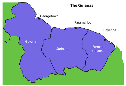 The Guianas of South America.
The coastal location of the Guianas provided European colonialists with an excellent site for plantation agriculture. Coastal cities had easy access to the Atlantic trade system. The active slave trade in the Atlantic brought African slaves to the Guianas to work the plantations. When slavery was abolished, indentured servants were brought in from other parts of the world that were colonized by the same European powers. Colonialism and plantation agriculture changed the cultural dynamics of the Guianas. Port cities along the coast are the dominant urban centers. The Guianas follow a pattern similar to that of the rimland of the Caribbean and are included with the Caribbean in many studies. At the present time, bauxite mining and oil deposits along the coast provide an income, and many people make their living in subsistence agriculture.
Guyana
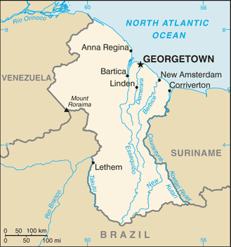 Map of Guyana
Guyana and its neighbors have a tropical type A climate. The main interior regions are covered with dense forests. Some deforestation has taken place in Guyana. Even so, forests cover more than 80 percent of Guyana’s land area with a diverse range of forests. These forests vary from dry evergreen forests to tropical rain forests, and with thousands of species of plants that are only found in this region.
Guyana’s natural habitats and biodiversity are unparalleled, which is because of the climate, distinctive landforms, and well-preserved ecosystems. Its large rain forests are the habitats for species not found elsewhere. The interior regions remain more than 70 percent pristine, but this will change if logging, mining, and deforestation are not managed.
Guyana was called British Guiana before it became independent in 1966. The region was home to Carib and Arawak groups before the arrival of the Dutch, who established the first colony there in 1616. By 1831, the British had taken control and declared the colony British Guiana. African slaves were the main source of plantation labor until slavery was abolished in 1834. At that point, indentured servants from many countries were recruited for labor. Most of the indentured servants were East Indians from South Asia. There were also thousands of servants from China and other countries.
The ethnic background of Guyana’s population, which is less than one million, is a mix of African (36 percent), East Indian (50 percent), and Amerindian (7 percent). The remainder is mixed and European. The religious background of the East Indians includes both Hindus and Muslims. About 50 percent of the population has converted to Christianity. Ethnic divisions create difficulties in organizing politics and social activities. For example, one political concern is that minority groups with greater economic advantages will dominate the political arena without regard to other ethnic groups.
Most of Guyana’s people live in the coastal regions. The almost impenetrable interior has large uninhabited areas with dense tropical forests. To protect its unique biodiversity, large areas have been placed in conservation areas and national parks. More than one million acres have been placed in the Konashen Community-Owned Conservation Area (COCA) to help preserve the natural environment and provide a sustainable economic relationship with local Waiwai people. In a similar effort, the government created the Kaieteur National Park, which features the spectacular Kaieteur Falls. They are about five times higher than Niagara Falls in North America. Other areas of Guyana are also being considered for preservation.
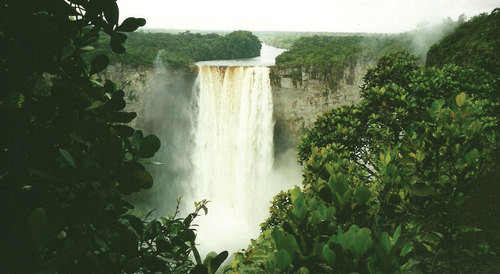 Kaieteur Falls has the largest single-drop waterfall by volume in the world. A national park has been created in this area to include the falls.
Guyana's economy is based on agricultural activities and the export of extracted natural resources. Sugarcane is a main cash crop, and timber sales are increasing. Fishing is common in coastal areas. Bauxite mining has been the main mining activity, and mining of gold and other minerals has only advanced in recent years. Guyana's economy is similar to that of many islands of the Caribbean, a relationship exemplified by its membership in CARICOM (the Caribbean Community). CARICOM's headquarters is located in Georgetown, the capital of Guyana.
Suriname
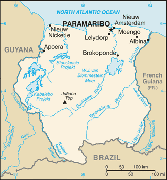 Map of Suriname
Suriname’s colonial name was Dutch Guiana. The name was changed when independence was granted in 1975. The cultural background of the colony is as diverse as its history. Dutch Guiana was divided between British and Dutch colonists. Slavery and plantation agriculture were introduced in the colonial period, and the harsh conditions of slavery caused many slaves to escape the plantations and live in the forests. These runaway slaves, called Maroons, eventually organized into viable independent groups. Peace treaties were finally made with the Maroons to grant them legitimate rights. After slavery was abolished, indentured servants from South Asia and the Dutch East Indies (Indonesia) were conscripted into the colony’s labor base.
Most of the half-million people who live in Suriname today live along the coast. The ethnic background of the people includes East Indian (37 percent), Creole (31 percent), Indonesian (15 percent), African (10 percent), Amerindian (2 percent), Chinese (2 percent), and European (about 1 percent). All three of the Guianas are ethnically diverse, and in this setting, diversity creates social and economic tensions. Guyana and Suriname are the least Latin regions of South America. The Creoles, for example, are mainly a mix of African and Dutch mixed with Asian or Amerindian. Establishing a stable government and conducting civil affairs are often complicated by the ethnic groups that fight for power and political control. The religious background in Suriname includes Hindu, Muslim, Christian, and a mix of African religions such as Winti.
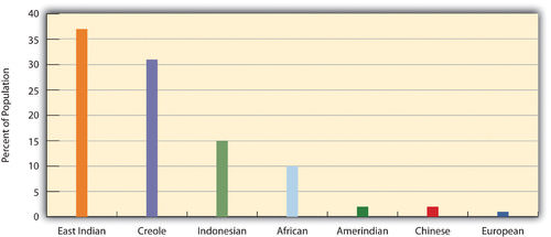 This graphic illustrates the ethnic groups of Suriname by percentage of the population.
Suriname depends on agriculture and natural resources as its two main economic activities. Suriname has the smallest physical area of all the independent South American states. It has a limited ability to provide opportunities and advantages for its growing population. Bauxite is the country’s main export product. In 1941, during World War II, the United States occupied the country to secure the valuable bauxite mines that were critical to the war effort. Suriname has also been expanding its gold mining, oil extraction, logging, and fishing industries. To protect its natural environment and its extensive biodiversity, the country has established national parks and created the large Central Suriname Nature Reserve, which UNESCO has named a World Heritage Site. Suriname hopes to benefit from these measures to create an ecotourism market.
Both Guyana and Suriname have had border disputes with their neighbors. Guyana has been locked in a challenge with Venezuela over its western region, which Venezuela claimed during the colonial era. A 1905 treaty ruled in Guyana’s favor, but a small portion is still under dispute. The corner of Surname that borders Brazil and Guyana has been an issue of contention fueled by the potential for mining of gold and other minerals in the area. The maritime boundary between Suriname and Guyana is also a point of contention. Suriname’s border with French Guiana has a disputed area along the southern corner next to Brazil. These disputes emerged out of colonial agreements and poorly defined treaty boundaries.
French Guiana
French Guiana is still a colony (department) of France. With fewer than 250,000 people in an area slightly smaller than Kentucky, this is a sparsely inhabited area. Half of the population lives in the capital city of Cayenne. Most of the population is Creole, mainly a combination of African and French with various Asian groups mixed in. The people work in subsistence agriculture or for the French government. A noted feature of the colony’s heritage is the former off-shore prison on Devil’s Island, which France used to secure its most undesirable prisoners. More than 50,000 French prisoners were delivered to the Devil’s Island facility during the colonial era, but less than 10 percent survived. The prison was closed in 1951.
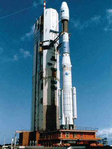 This Ariane 42P was launched from the European Space Agency’s Guiana Space Center in Kourou, French Guiana, on August 10, 1992.
The European Space Agency maintains a launch center in French Guiana because of its favorable climate and launch conditions. France maintains the facility and has subsidized the department's economy. This European support provides the population with a higher standard of living than in many other South American countries. Economic activities have included fishing, agriculture (bananas and sugar) and logging. Deforestation from the sale of hardwood lumber has become a problem throughout the Guianas as it leaves the soil open for erosion. Logging endangers the area's fragile but extensive biodiversity. Roads, dams, and gold mining have also contributed to the erosive destruction of the environment.
Cultural Regions of South America
Colonialism changed the ethnicity, religion, language, and economic activities of the people in South America. The past 500 years have molded the current states and regions of the South American continent. To identify standards of living, ethnic majorities, and economic conditions, it is helpful to map out South America’s various cultural regions.
In South America, five main cultural regions indicate the majority of ethnic groups and the main economic activities:
- Tropical Plantation (region)
- Rural Amerindian (region)
- Amazon Basin
- Mixed Mestizo (region)
- European Commercial--Southern Cone (region)
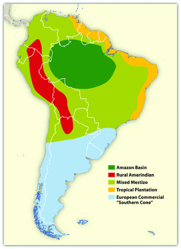 This graphic illustrates the cultural spheres of South America.
These are generalized regions that provide a basic understanding of the whole continent. Technological advancements and globalization have increased the integration of the continent to the point that these regions are not as delineated as they once were, but they still provide a context in which to understand the ethnic and cultural differences that exist within the realm.
Tropical Plantation Region
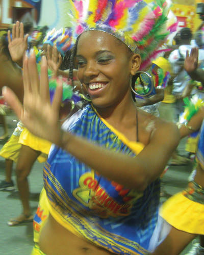 Salvador, Brazil, is located along the coastal region of South America where the Tropical Plantation Region was prominent. Most people in this region are of African descent.
Located along the north and east coast of South America, the Tropical Plantation Region resembles the Caribbean rimland in its culture and economic activity. The region, which extends as far south as the Tropic of Capricorn, has a tropical climate and an agricultural economy. Europeans opened up this area for plantation agriculture because of coastal access for ships and trade. The local people were forced into slavery, but when the local people died or escaped, millions of African slaves were brought in to replace them. After slavery was abolished, indentured servants from Asia were brought to the Guianas to work the plantations. The Tropical Plantation Region has a high percentage of people of African or Asian descent.
Rural Amerindian Region
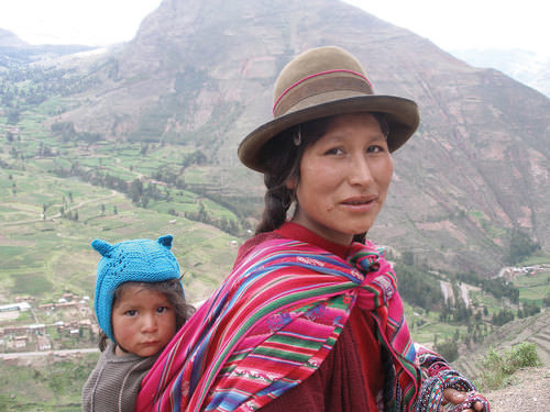 The Amerindian woman and child in this photo live in the Sacred Valley of the Andes in Peru.
The Rural Amerindian Region includes the countries of Ecuador, Peru, and Bolivia. The ruling Mestizo class that inherited control from the European conquistadors mainly lives in urban areas. Most of the rural Amerindian population lives in mountainous areas with type H climates and survives by subsistence agriculture. This is one of the poorest regions of South America, and land and politics are controlled by powerful elites. The extraction of gold and silver has not benefited the local Amerindian majority, which holds to local customs and speaks local languages.
Amazon Basin
The Amazon Basin, which is characterized by a type A climate, is the least-densely populated region of South America and is home to isolated Amerindian groups. The development has encroached upon the region in the forms of deforestation, mining, and cattle ranching. Large deposits of iron ore, along with gold and other minerals, have been found in the Amazon Basin. Preservation of the tropical rain forest of this remote region has been hampered by the destructive pattern of development that has pushed into the region. The future of the basin is unclear because of development patterns that are expected to continue as Brazil seeks to exploit its interior peripheral region. Conflicts over land claims and the autonomy of Amerindian groups are on the rise.
 The Amazon has more than 1,100 tributaries.
Mixed Mestizo Region
The Mixed Mestizo Region includes the coastal area of the west and the interior highlands of the north and east. This region between the Tropical Plantation Region and the Rural Amerindian Region includes a majority of people who share a mixed European and Amerindian ethnicity. It is not as poor as the Rural Amerindian Region and yet not as wealthy as the European-dominated region to the south. Paraguay falls into the Mixed Mestizo Region, as do other portions of other South American countries such as parts of Brazil, Colombia, and Venezuela. Paraguay is mainly Mestizo, but its economic qualities resemble that of the Rural Amerindian Region to the north, even though Paraguay is not located in the mountains.
European Commercial Region (Southern Cone)
The southern part of South America, called the European Commercial Region or the Southern Cone, includes Chile, Argentina, Uruguay, and parts of Brazil. European ethnic groups dominate this region and include not only Spanish and Portuguese but also German, Austrian, Italian, and other European ethnic heritages. Fertile soils and European trade provided early economic growth, and the region attracted industry and manufacturing in the later decades of the 20th century.
There are not many Amerindians or people of African descent here. More than 90 percent of all the people in Argentina, Chile, and Uruguay are of European descent and live in urban areas. With a highly urbanized population and with trade connections to a globalized economy, the Southern Cone is home to South America’s most developed economies.
Globalization and Trade
South America has been fragmented by European colonialism. The colonial economic patterns did not encourage the South American countries to work together to create an integrated continental trade network. Countries outside the continent have promoted trade partnerships to benefit from South America’s natural resources and agricultural exports. The establishment of the European Union and the North American Free Trade Agreement (NAFTA) created globalized trading blocs that challenged the South American countries to consider how to take advantage of trading opportunities within their realm to protect and support their own economic interests.
Since the 1990's, cooperation and business ventures have started to form within the realm to create a more integrated network of trade and commerce to benefit the countries of South America. Transportation and communication systems are being developed through joint ventures by internal investment groups. River and road systems continue to be managed and developed for improved transport of people and goods throughout the continent. Free-trade agreements have been implemented to support the integration of internal economic networks and competition in the global marketplace.
In 2008, the South American countries formed the Union of South American Nations (UNASUR) to oversee the customs unions and trade agreements within the realm. One of the more established trade associations is Mercosur (the Southern Cone Common Market), created in 1995 by the southern countries. It has evolved to include most countries in South America and is the most dominant trade agreement in the realm. Full members of Mercosur include Argentina, Uruguay, Paraguay, and Brazil. Chile, Bolivia, Peru, Ecuador, and Colombia are associate members. As of 2011, Venezuela’s membership was under review.
The Andean Community (Colombia, Ecuador, Peru, and Bolivia) was established in 1969 but did not gain ground until 1995, when it established stronger trade measures. Multinational corporations have supported the creation of a Free Trade Area of the Americas (FTAA) to include all of the Western Hemisphere in one unified trade association. It has not been approved and has received strong opposition from Mercosur and economic forces that support a more localized economy controlled by local people.
South America faced division and competition during the colonial era between the Spanish and the Portuguese. Today’s new era of corporate colonialism has created similar fragmentation and divisions. The level of trade between the countries of South America and the United States and Europe varies widely. Countries such as Colombia and Chile have well-established trade relationships with the United States and are unwilling to jeopardize those trade connections to strengthen ties with their neighbors that have less-supportive political relationships with the United States.
External global trade arrangements often provide financial benefits to individual countries that might not be shared by the bordering countries in the same region. South America’s historical fragmentation has not made it easy to unify the continent under a singular trade agreement to complete against the European Union or NAFTA.
- The extensive Andes Mountain chain and the massive Amazon River dominate the realm’s physical geography.
- The Spanish and the Portuguese were the two main colonial powers that dominated South America.
- The Guianas were the only part of the continent not dominated by these the Spanish and the Portuguese.
- Britain, Holland, and France formed colonies in the Guianas.
- The slave trade brought many people of African descent to the Guiana colonies.
- After slavery was abolished, indentured servants from Asia were brought to the Guianas to support the labor base.
- Identifying the majority of ethnic groups in South America can be helpful in classifying the various cultural regions of the realm.
- Colonial activities and ethnic backgrounds are consistent enough to formulate regions with similar characteristics.
- Globalization and the creation of economic or political units such as the European Union and NAFTA have prompted the South American countries to work together to implement cooperative trade agreements and create the Union of South American Nations.
Vocabulary Terms
| Andes | long mountain range that runs down the west coast of South America |
| Atacama Desert | found in Chile, is the hottest desert on earth |
| Francisco Pizarro | Spanish conquistador who conquered the Inca |
| Inca | A Mesoamerican civilization that was an empire. They lived in the Andes Mountains of South America (Ecuador, Peru, and Chile). They kept records using a complicated system of colored knotted cords called quipus. Pizarro conquered them in 1535 |
| Llanos | grassland located in Colombia and Venezuela |
| Jose de San Martin | A general who led a war for South American independence beginning in 1810. His leadership freed the southern parts of South America from Spain and Portugal |
| MERCOSUR | An economic and political bloc comprising Argentina, Brazil, Paraguay, Uruguay, and Venezuela |
| Pampas | grassland located in Argentina and Uruguay. Known for cattle ranching |
| Simon Bolivar | A general who led a war in 1810 for South American independence. His leadership freed the northern parts of South America from Spain and Portugal. He was known as "the Liberator" |
Applying Knowledge
Interactive Notebook Activities
- Summarize the main physical features and characteristics of South America.
- Explain how European colonialism dominated the realm and divided up the continent.
- Describe the ethnic, economic, and political patterns in the Guianas.
- List the main cultural realms of South America.
- Describe each realm’s main ethnic majority.
- Explain how colonialism impacted each region.
- Summarize briefly how the South American countries are integrating their economies.
Discussion and Study Questions
- What are the two main physical features of South America? Where are they located?
- What two main European colonial powers dominated South America?
- What are the majority ethnic groups in each of the Guianas?
- How do most people in the Guianas make a living?
- Where are the five main cultural regions of South America?
- What are the majority ethnic groups in each of the cultural regions of the continent?
- Why would the Southern Cone have a stronger economic position than other regions?
- What are the environmental concerns in the Guianas?
- What are the main economic trade agreements for the South American countries?
- Why has it been so difficult to unify the countries in this realm into a single trade zone?
Real-World Geography Exercise
- Using Google Maps, complete the following activities:
- Locate each place on the bulleted list below.
- Find the nearest city with an international airport in proximity to each location on the bulleted list below.
- Calculate the distance and travel time by plane to each city from the Ted Stevens Anchorage International Airport in Anchorage, Alaska.
- Using NASA Latitude and Longitude Finder, determine the latitude and longitude for each location on the bulleted list below.
- Be prepared to share and discuss your answers.
- Altiplano
- Amazon Basin
- Amazon River
- Andes Mountains
- Atacama Desert
- Brazilian Highlands
- Cape Horn
- Cerrado
- Devil’s Island
- Easter Island
- European Commercial Region
- Falkland Islands
- Galapagos Islands
- Guiana Highlands
- Guianas
- Lake Maracaibo
- Lake Titicaca
- Llanos
- Madeira River
- Mato Grosso Plateau
- Mixed Mestizo Region
- Orinoco River
- Pampas
- Paraguay River
- Paraná River
- Patagonia
- Rio de la Plata
- Rio Negro
- Robinson Crusoe Island
- Rural Amerindian Region
- Sao Francisco River
- Southern Cone
- Tierra del Fuego
- Tordesillas Line
- Tropical Plantation Region
- Xingu River
Mapping Exercise
GEO Inquiry Mountain Building: Illustrate and explore how global mountain ranges are formed in relation to plate motions.
Videos for Geography Enrichment
Helpful Websites for the Study of Geography
Canadian Encyclopedia is an encyclopedia funded by the Canadian government covering all branches of knowledge. Their scholarly collection includes interactive materials.
CIA World Factbook provides information on the people, history, government, economy, energy, geography, communications, transportation, military, and transnational issues for the world's entities.
Congress.gov is a US government website where you can find federal legislation, past and present, as well as information about the US legal system.
Drug Enforcement Administration (DEA) is a government agency website that provides current news, resources, topics of interest, information about drugs, careers in the DEA, and a tip hotline.
Library of Congress is the largest library in the world and provides manuscripts, files, information, pictures, and videos.
NASA Earth Observatory (NEO) is a US government agency website that allows users to search for and retrieve satellite images of Earth.
National Archives is a US government website that provides historical documents, photos, records, publications, and educator resources.
National Oceanic and Atmospheric Association (NOAA) is a US government agency website that provides weather-related information and ocean research.
National Map is a website by the United States Geological Survey and other federal, state, and local agencies that deliver topographic information for the United States.
NationMaster is a massive central data source and a handy way to graphically compare nations.
Real-Time World Air Quality Index is a website that measures most locations in the world for air pollution in real time.
StateMaster is a unique statistical database, which allows you to research and compare a multitude of different data on US states.
United Nations (UN) is an international organization founded in 1945 and made up of 193 member states. The UN maintains international peace and security, protects human rights, delivers humanitarian aid, promotes sustainable development, and upholds international law.
United States Census Bureau is a US government agency that provides a population clock, data, surveys, statistics, a library with information and infographics, news about the economy, and much more.
United States Geological Survey (USGS) is a US government agency website that provides scientific information about the natural hazards that threaten lives, the natural resources we rely on, the health of our ecosystems and environment, and the impacts of climate and land-use change.
Whitehouse.gov is a US government website that provides the latest presidential news, information about the budget, policy, defense, and many more topics.
World Health Organization (WHO) is under the United Nations and provides leadership on matters critical to health, shapes the research agenda on health, and monitors the health situation and assessing health trends around the world. Their website provides information on the state of health around the world, outbreaks, current health news, and more.
World Trade Organization (WTO) is an intergovernmental organization that regulates international trade. The website provides information on the history of the multilateral trading system, featured videos, news and events, trade topics, and more.
| Image | Reference | Attributions |
 |
[Figure 1] | Credit: http://open.lib.umn.edu/worldgeograp...south-america/ Source: http://open.lib.umn.edu/worldgeography/part/chapter-6-south-america/ License: CC BY-NC 3.0 |
 |
[Figure 2] | Credit: Benedict Adam – Peru – CC BY 2.0. Source: open.lib.umn.edu/worldgeography/wp-content/uploads/sites/181/2016/04/b9588973157f231ced228dd558312fd9.jpg License: CC BY-NC 3.0 |
 |
[Figure 3] | Credit: http://open.lib.umn.edu/worldgeograp...ing-the-realm/ Source: open.lib.umn.edu/worldgeography/wp-content/uploads/sites/181/2016/04/ea26b3f32636e9e786100d3b7e407ba3.jpg License: CC BY-NC 3.0 |
 |
[Figure 4] | Credit: James Preston – La Compania de Jesus, Cusco – CC BY 2.0. Source: open.lib.umn.edu/worldgeography/wp-content/uploads/sites/181/2016/04/a4ea5fc91bacf29c8b2e6c5b6e66a2bc.jpg License: CC BY-NC 3.0 |
 |
[Figure 5] | Credit: http://open.lib.umn.edu/worldgeograp...ing-the-realm/ Source: open.lib.umn.edu/worldgeography/wp-content/uploads/sites/181/2016/04/ab1e86ae729b7140f1faf37c0ec13295.jpg License: CC BY-NC 3.0 |
 |
[Figure 6] | Credit: cia world factbook Source: https://www.cia.gov/library/publications/the-world-factbook/geos/gy.html License: CC BY-NC 3.0 |
 |
[Figure 7] | Credit: Paul Arps – Kaietur falls from a distance (Guyana 2001) – CC BY 2.0. Source: open.lib.umn.edu/worldgeography/wp-content/uploads/sites/181/2016/04/370738ebe0ab0128f950036592fae081.jpg License: CC BY-NC 3.0 |
 |
[Figure 8] | Credit: cia world factbook Source: https://www.cia.gov/library/publications/the-world-factbook/geos/ns.html License: CC BY-NC 3.0 |
 |
[Figure 9] | Credit: http://open.lib.umn.edu/worldgeograp...ing-the-realm/ Source: open.lib.umn.edu/worldgeography/wp-content/uploads/sites/181/2016/04/711977b61ea9a9735efb4b23e9f8e8b1.jpg License: CC BY-NC 3.0 |
 |
[Figure 10] | Credit: Photo courtesy of NASA – public domain. Source: open.lib.umn.edu/worldgeography/wp-content/uploads/sites/181/2016/04/ce55a964275697638ea6ea43716cf367.jpg License: CC BY-NC 3.0 |
 |
[Figure 11] | Credit: http://open.lib.umn.edu/worldgeograp...ing-the-realm/ Source: open.lib.umn.edu/worldgeography/wp-content/uploads/sites/181/2016/04/6a842f6e52cae38efe5083585ff770e8.jpg License: CC BY-NC 3.0 |
 |
[Figure 12] | Credit: Carnal.com Studios – Salvador Carnaval Comanches 03 – CC BY 2.0. Source: open.lib.umn.edu/worldgeography/wp-content/uploads/sites/181/2016/04/40509e6b81bb5e4b90e4586bc811b57d.jpg License: CC BY-NC 3.0 |
 |
[Figure 13] | Credit: Thomas Quine – Mother and Child – CC BY 2.0. Source: open.lib.umn.edu/worldgeography/wp-content/uploads/sites/181/2016/04/c28dedb23650c748f8cc226f5a76e2f9.jpg License: CC BY-NC 3.0 |
 |
[Figure 14] | Credit: Image courtesy of NASA – public domain. Source: open.lib.umn.edu/worldgeography/wp-content/uploads/sites/181/2016/04/bb8f48c1aee1d754d39eb44e7c82e35f.jpg License: CC BY-NC 3.0 |