4.4: The Caribbean (1 Day)
- Page ID
- 1960
\( \newcommand{\vecs}[1]{\overset { \scriptstyle \rightharpoonup} {\mathbf{#1}} } \)
\( \newcommand{\vecd}[1]{\overset{-\!-\!\rightharpoonup}{\vphantom{a}\smash {#1}}} \)
\( \newcommand{\dsum}{\displaystyle\sum\limits} \)
\( \newcommand{\dint}{\displaystyle\int\limits} \)
\( \newcommand{\dlim}{\displaystyle\lim\limits} \)
\( \newcommand{\id}{\mathrm{id}}\) \( \newcommand{\Span}{\mathrm{span}}\)
( \newcommand{\kernel}{\mathrm{null}\,}\) \( \newcommand{\range}{\mathrm{range}\,}\)
\( \newcommand{\RealPart}{\mathrm{Re}}\) \( \newcommand{\ImaginaryPart}{\mathrm{Im}}\)
\( \newcommand{\Argument}{\mathrm{Arg}}\) \( \newcommand{\norm}[1]{\| #1 \|}\)
\( \newcommand{\inner}[2]{\langle #1, #2 \rangle}\)
\( \newcommand{\Span}{\mathrm{span}}\)
\( \newcommand{\id}{\mathrm{id}}\)
\( \newcommand{\Span}{\mathrm{span}}\)
\( \newcommand{\kernel}{\mathrm{null}\,}\)
\( \newcommand{\range}{\mathrm{range}\,}\)
\( \newcommand{\RealPart}{\mathrm{Re}}\)
\( \newcommand{\ImaginaryPart}{\mathrm{Im}}\)
\( \newcommand{\Argument}{\mathrm{Arg}}\)
\( \newcommand{\norm}[1]{\| #1 \|}\)
\( \newcommand{\inner}[2]{\langle #1, #2 \rangle}\)
\( \newcommand{\Span}{\mathrm{span}}\) \( \newcommand{\AA}{\unicode[.8,0]{x212B}}\)
\( \newcommand{\vectorA}[1]{\vec{#1}} % arrow\)
\( \newcommand{\vectorAt}[1]{\vec{\text{#1}}} % arrow\)
\( \newcommand{\vectorB}[1]{\overset { \scriptstyle \rightharpoonup} {\mathbf{#1}} } \)
\( \newcommand{\vectorC}[1]{\textbf{#1}} \)
\( \newcommand{\vectorD}[1]{\overrightarrow{#1}} \)
\( \newcommand{\vectorDt}[1]{\overrightarrow{\text{#1}}} \)
\( \newcommand{\vectE}[1]{\overset{-\!-\!\rightharpoonup}{\vphantom{a}\smash{\mathbf {#1}}}} \)
\( \newcommand{\vecs}[1]{\overset { \scriptstyle \rightharpoonup} {\mathbf{#1}} } \)
\(\newcommand{\longvect}{\overrightarrow}\)
\( \newcommand{\vecd}[1]{\overset{-\!-\!\rightharpoonup}{\vphantom{a}\smash {#1}}} \)
\(\newcommand{\avec}{\mathbf a}\) \(\newcommand{\bvec}{\mathbf b}\) \(\newcommand{\cvec}{\mathbf c}\) \(\newcommand{\dvec}{\mathbf d}\) \(\newcommand{\dtil}{\widetilde{\mathbf d}}\) \(\newcommand{\evec}{\mathbf e}\) \(\newcommand{\fvec}{\mathbf f}\) \(\newcommand{\nvec}{\mathbf n}\) \(\newcommand{\pvec}{\mathbf p}\) \(\newcommand{\qvec}{\mathbf q}\) \(\newcommand{\svec}{\mathbf s}\) \(\newcommand{\tvec}{\mathbf t}\) \(\newcommand{\uvec}{\mathbf u}\) \(\newcommand{\vvec}{\mathbf v}\) \(\newcommand{\wvec}{\mathbf w}\) \(\newcommand{\xvec}{\mathbf x}\) \(\newcommand{\yvec}{\mathbf y}\) \(\newcommand{\zvec}{\mathbf z}\) \(\newcommand{\rvec}{\mathbf r}\) \(\newcommand{\mvec}{\mathbf m}\) \(\newcommand{\zerovec}{\mathbf 0}\) \(\newcommand{\onevec}{\mathbf 1}\) \(\newcommand{\real}{\mathbb R}\) \(\newcommand{\twovec}[2]{\left[\begin{array}{r}#1 \\ #2 \end{array}\right]}\) \(\newcommand{\ctwovec}[2]{\left[\begin{array}{c}#1 \\ #2 \end{array}\right]}\) \(\newcommand{\threevec}[3]{\left[\begin{array}{r}#1 \\ #2 \\ #3 \end{array}\right]}\) \(\newcommand{\cthreevec}[3]{\left[\begin{array}{c}#1 \\ #2 \\ #3 \end{array}\right]}\) \(\newcommand{\fourvec}[4]{\left[\begin{array}{r}#1 \\ #2 \\ #3 \\ #4 \end{array}\right]}\) \(\newcommand{\cfourvec}[4]{\left[\begin{array}{c}#1 \\ #2 \\ #3 \\ #4 \end{array}\right]}\) \(\newcommand{\fivevec}[5]{\left[\begin{array}{r}#1 \\ #2 \\ #3 \\ #4 \\ #5 \\ \end{array}\right]}\) \(\newcommand{\cfivevec}[5]{\left[\begin{array}{c}#1 \\ #2 \\ #3 \\ #4 \\ #5 \\ \end{array}\right]}\) \(\newcommand{\mattwo}[4]{\left[\begin{array}{rr}#1 \amp #2 \\ #3 \amp #4 \\ \end{array}\right]}\) \(\newcommand{\laspan}[1]{\text{Span}\{#1\}}\) \(\newcommand{\bcal}{\cal B}\) \(\newcommand{\ccal}{\cal C}\) \(\newcommand{\scal}{\cal S}\) \(\newcommand{\wcal}{\cal W}\) \(\newcommand{\ecal}{\cal E}\) \(\newcommand{\coords}[2]{\left\{#1\right\}_{#2}}\) \(\newcommand{\gray}[1]{\color{gray}{#1}}\) \(\newcommand{\lgray}[1]{\color{lightgray}{#1}}\) \(\newcommand{\rank}{\operatorname{rank}}\) \(\newcommand{\row}{\text{Row}}\) \(\newcommand{\col}{\text{Col}}\) \(\renewcommand{\row}{\text{Row}}\) \(\newcommand{\nul}{\text{Nul}}\) \(\newcommand{\var}{\text{Var}}\) \(\newcommand{\corr}{\text{corr}}\) \(\newcommand{\len}[1]{\left|#1\right|}\) \(\newcommand{\bbar}{\overline{\bvec}}\) \(\newcommand{\bhat}{\widehat{\bvec}}\) \(\newcommand{\bperp}{\bvec^\perp}\) \(\newcommand{\xhat}{\widehat{\xvec}}\) \(\newcommand{\vhat}{\widehat{\vvec}}\) \(\newcommand{\uhat}{\widehat{\uvec}}\) \(\newcommand{\what}{\widehat{\wvec}}\) \(\newcommand{\Sighat}{\widehat{\Sigma}}\) \(\newcommand{\lt}{<}\) \(\newcommand{\gt}{>}\) \(\newcommand{\amp}{&}\) \(\definecolor{fillinmathshade}{gray}{0.9}\)- Describe how the physical environment has affected human activity in the region.
- Summarize in a few sentences the various ways in which colonialism has impacted the islands.
- Explain why the United States has an economic embargo against the socialist country of Cuba.
- Explain how tourism has become the main means of economic development for most of the Caribbean.
- Identify and list the main music genres that have emerged from the Caribbean.
TEKS Regional Unit 04: Latin America; Chapter 4.4 Caribbean
WG.1A Analyze the effects of physical and human geographic patterns and processes on the past and describe their impact on the present, including significant physical features and environmental conditions that influenced migration patterns and shaped the distribution of culture groups today.
WG.2A Describe the human and physical characteristics of the same regions at different periods of time to evaluate relationships between past events and current conditions.
WG.2B Explain how changes in societies have led to diverse uses of physical features.
WG.3A Explain weather conditions and climate in relation to annual changes in Earth-Sun relationships.
WG.4B Explain the influence of climate on the distribution of biomes in different regions.
WG.5A Analyze how the character of a place is related to its political, economic, social, and cultural elements.
WG.5B Interpret political, economic, social, and demographic indicators (gross domestic product per capita, life expectancy, literacy, and infant mortality) to determine the level of development and standard of living in nations using the terms Human Development Index, less developed, newly industrialized, and more developed.
WG.6A Locate and describe human and physical features that influence the size and distribution of settlements.
WG.8A Compare ways that humans depend on, adapt to, and modify the physical environment, including the influences of culture and technology.
WG.9A Identify physical and/or human factors such as climate, vegetation, language, trade networks, political units, river systems, and religion that constitute a region.
WG.10B Classify where specific countries fall along the economic spectrum between free enterprise and communism.
WG.14A Analyze current events to infer the physical and human processes that lead to the formation of boundaries and other political divisions.
WG.14B Compare how democracy, dictatorship, monarchy, republic, theocracy, and totalitarian systems operate in specific countries.
WG.22A Design and draw appropriate graphics such as maps, diagrams, tables, and graphs to communicate geographic features, distributions, and relationships.
WG.22C Use geographic terminology correctly.
WG.22D Use standard grammar, spelling, sentence structure, and punctuation.
TEKS and ELPS for Regional World Geography Unit 04--Latin America from TEKS Resource System
The Caribbean's Physical Characteristics
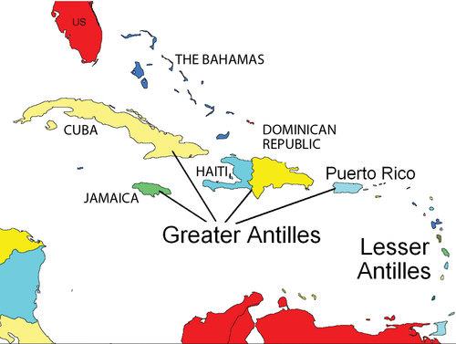
Caribbean Regions of the Greater Antilles, the Lesser Antilles, and the Bahamas
The regions of Middle America and South America, including the Caribbean, follow similar colonial patterns of invasion, dominance, and development by outside European powers. The Caribbean Basin is often divided into the Greater Antilles and the Lesser Antilles (the bigger islands and the smaller islands, respectively). The Greater Antilles includes the four large islands of Cuba, Jamaica, Hispaniola, and Puerto Rico. The Lesser Antilles are in the eastern and southern region.
The Bahamas are located in the Atlantic Ocean, not in the Caribbean Sea. They are usually associated with the Caribbean region and are often associated with the Lesser Antilles. Middle America can be divided into two geographic areas according to occupational activities and colonial dynamics. The rimland includes the Caribbean islands and the Caribbean coastal areas of Central America. The mainland includes the interior of Mexico and Central America.
Many of the Caribbean islands experience the rain shadow effect. Jamaica has as much as a 20-inch difference in rainfall between the north side and south side of the island because most of the rain falls on the north side, where the prevailing winds hit the island. The Blue Mountains on the eastern part of the island provide a rain shadow effect. Puerto Rico has a tropical rain forest on the northeastern part of the island, which receives a large amount of rainfall.
The rain shadow effect creates semi-desert conditions on the southwestern side of Puerto Rico because the southwestern side receives little rainfall. Low elevation islands such as the Bahamas do not receive as much rain because they are not high enough to affect the precipitation patterns of rain clouds.
European Colonialism in the Caribbean
The Spanish were not the only Europeans to take advantage of colonial expansion in the Caribbean. The English, French, Dutch, and other Europeans followed. Most of the European colonial countries were located on the west coast of Europe, which had a seafaring heritage. This included smaller countries such as Denmark, Sweden, and Belgium. The Caribbean Basin became an active region for European ships to enter and vie for possession of each island.
Many of the Caribbean islands changed hands several times before finally being secured as established colonies (see "Historical Caribbean Colonizers"). The languages, religions, and economic activities of the colonized islands reflected those of the European colonizers rather than those of the native people who had inhabited the islands originally.
The four main colonial powers in the Caribbean were the Spanish, English, Dutch, and French. Other countries that held possession of various islands at different times were Portugal, Sweden, and Denmark. The United States became a colonial power when they gained Cuba and Puerto Rico as a result of the Spanish-American War. The US Virgin Islands were purchased from Denmark in 1918. Sweden controlled the island of St. Barthelemy from 1784 to 1878 before trading it back to the French, who had been the original colonizer. Portugal originally colonized Barbados before abandoning it to the British.
| Colonizer | European colonies |
| Spain | Cuba, Dominican Republic, Puerto Rico |
| British | Bahamas, Jamaica, Cayman Islands, Turks and Caicos Islands, Antigua, Dominica, St. Lucia, St. Vincent, Grenada, Barbados, Virgin Islands, Trinidad and Tobago, Montserrat, Anguilla, St. Kitts and Nevis |
| Dutch | Curacao, Bonaire, Aruba, St. Eustatius, Saba and Sint Maarten (south half) |
| French | Haiti, Guadeloupe, Martinique, St. Martin (north half), St. Barthelemy |
| United States | Puerto Rico, Virgin Islands, Cuba |
Colonialism drastically altered the ethnic makeup of the Caribbean. Amerindians were almost eliminated after the arrival of Africans, Europeans, and Asians. Those of European descent are at the top of the socio-economic pyramid and control a higher percentage of wealth and power, even though they are a minority of the population. In the Caribbean, the middle class includes mulattos, or people with both African and European heritage. Many mulattos hold positions as managers, businesspeople, and professionals in the world of business.
In some countries, such as Haiti, the minority mulatto segment of the population makes up the power base and holds a political and economic advantage over the rest of the country. The working poor at the bottom of the socio-economic pyramid make up most of the population. In the Caribbean, the lower economic class contains the highest percentage of people of African heritage
Not only was colonialism what brought many Africans to the Caribbean through the slave trade, but it brought many people from Asia as well. Once slavery became illegal, the colonial powers brought indentured laborers to the Caribbean from their Asian colonies. Cuba was the destination for over 100,000 Chinese workers. The first Chinatown in the Western Hemisphere happened in Havana. Laborers from the British colonies of India and other parts of South Asia arrived by ship in various British colonies in the Caribbean. At the present time, about 40 percent of the population of Trinidad has South Asian heritage, and a large number follow the Hindu faith.
The Greater Antilles
Cuba
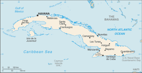
Map of Cuba
The largest island in the Greater Antilles is Cuba. It was transformed by the power of colonialism, the transition to plantation agriculture, and a socialist revolution. The island country of Cuba is slightly smaller in size than the US state of Pennsylvania. The elongated island has the Sierra Maestra mountains on its eastern end, the Escambray Mountains in the center, and the Western Karst region in the west, near Viñales. Low hills and fertile valleys cover more than half the island. The pristine waters of the Caribbean that surround the island make for some of the most attractive tourist locations in the Caribbean region.
Approximately 100,000 Amerindians inhabited Cuba when Christopher Columbus first landed on the island in 1492. Except for brief control by the British, the island was a Spanish colony until 1898. Plantation agriculture was established, and slaves provided the labor. History indicates that more than 800,000 African slaves were brought to Cuba between 1800 and 1870. Slave labor was in high demand on the extensive sugar plantations that dominated the island’s economy.
The African influence can still be witnessed today in the main religion of the island, Santeria, which is an overlay of African-based spirits on top of Catholic saints. At the present time, an estimated 70 percent of Cubans practice some aspect of Santeria.
With the defeat of Spain in the Spanish-American War, the United States gained possession of the Spanish possessions of Cuba, Puerto Rico, Guam, the Philippines, and various other islands. Cuba became independent in 1902, but it remained under US influence for decades.
Sugar plantations and the sugar industry came to be owned and operated by US interests, and wealthy Americans bought up large haciendas, farmland, and family estates, as well as industrial and business operations. Organized crime syndicates operated many of the nightclubs and casinos in Havana.
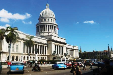
This photo shows the US "Colonial influence in Cuba. Notice the cars and architecture.
The Cuban Revolution
In January of 1934, with the encouragement of the US government, Fulgencio Batista led a coup that took control of the Cuban government. Fidel Castro, once a prisoner under Batista and having fled to Mexico in exile for a number of years, returned to Cuba to start a revolution. Joining him were his brother Raúl Castro and revolutionaries such as Che Guevara. Starting in the remote and rugged Sierra Maestra in the east, Castro rallied the support of the Cuban people. By the end of 1958, the Cuban Revolution brought down the US-backed Batista government. Castro gained power and had the support of most of the Cuban population.
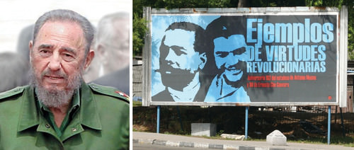
Fidel Castro (left); Billboard in Havana Promoting the Virtues of Revolutionaries Antonio Maceo and Che Guevara (right)
Castro worked to recover Cuba for Cubans. The government cleared rampant gambling from the island, forcing organized crime operations to shut down or move back to the United States. Castro nationalized all foreign landholdings and the sugar plantations, as well as all the utilities, port facilities, and other industries. Foreign ownership of land and businesses in Cuba was forbidden. Large estates, once owned by rich US families were taken over and recovered for Cuban purposes.
The United States Embargo Era
Castro’s policy of seizing and nationalizing businesses and property raised concerns in the United States. As a result, US President Dwight D. Eisenhower severed diplomatic relations with Cuba in 1960. He issued an executive order implementing a partial trade embargo to prohibit the importation of Cuban goods. Later presidents implemented a full-scale embargo, restricting travel and trade with Cuba. In March 1960, the Central Intelligence Agency (CIA) trained Cuban exiles for an invasion of Cuba at the Bay of Pigs, on the south side of the island. This failed invasion of the Bay of Pigs attempt only resulted in consolidating the Cuban people’s support for Castro and his socialist government.
To deter any further US plans of invading or destabilizing Cuba, Castro sought economic and military assistance from the Soviet Union. Soviet premier Nikita Khrushchev agreed to secretly send missiles armed with nuclear weapons capable of hitting targets within the United States. In September 1962, US spy planes identified the missile sites. On October 22, 1962, President John F. Kennedy announced a naval blockade of the island and informed Khrushchev that any Soviet ship crossing the blockade would be sunk.
At the last second, the two leaders resolved this dispute (called the Cuban Missile Crisis) before it erupted into a potential nuclear war. Khrushchev recalled the ships and agreed to dismantle the Cuban missile sites. In return, the United States agreed not to invade Cuba and to remove US missiles from sites in Turkey that were aimed at the Soviet Union.
The collapse of the Soviet Union in 1991 caused a downturn in Cuba’s economy. With the loss of Soviet aid, the 1990s was a period of transition for Cubans. Castro turned to tourism and foreign investment to shore up his failing economy. Tensions between the United States and Cuba did not improve. In 1996, the United States strengthened the trade embargo with the Helms-Burton Act.
At the turn of the 21st century, Cuba emerged as the lone Communist state in the Americas. Castro was the longest-governing leader of any country in the world. He never kept his promises of holding free elections. Rather, he cracked down on dissent and suppressed free speech. He turned over power to his brother Raúl in 2006.
A Post-Castro Cuba
With Fidel Castro no longer in power, Cuba’s future looks positive, though difficult. The island has natural resources, a great climate, and an excellent location but is also struggling economically. Cuba has standardized health care, though medical supplies are often in short supply. The Cubans who live in dire poverty look to the future for relief. Personal freedoms have been marginal, and reforms are slowly taking place in the post-Fidel era.
As the largest island in the Caribbean, Cuba has the potential to become an economic power for the region. There is vast US interest in regaining US dominance of the Cuban economy and corporate colonialists would like to profit from Cuba’s economic potential. Keeping corporate colonialism out is what Fidel’s socialist experiment worked so hard to achieve, even at the expense of depriving the Cuban people of civil rights and economic reforms.
Cuba today is in transition from a socialist to a more capitalist economy and relies on outside sources for energy and food. In 2008, the average wage in Cuba was about $20 dollars per month. There was almost total employment, and everyone had equal access to free health care, education, and housing. At the same time, the underground informal economy was thriving and was pushing the formal economy to make changes.
Raúl Castro declared that workers with different skills and occupations could earn wages at varying levels. Cubans are now allowed to have cell phones and computers, though Internet access has been restricted by the Cuban government. More goods and money are being brought in from Cuban family members who live in the United States. The US government grants general licenses to allow a number of categories of people to travel to Cuba. It is only a matter of time before full travel restrictions are lifted.
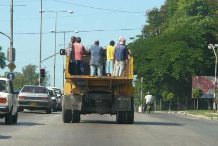
Cubans use all available resources and opportunities to get by. These people are catching a ride on a dump truck to get where they want to go.
Cuba is counting on tourism for an added economic boost. With some of the finest beaches and the clearest waters in the Caribbean, Cuba is a magnet for tourists and water sports enthusiasts. Its countryside is full of wonders and scenic areas. The beautiful Viñales Valley in western Cuba has been listed as a UNESCO World Heritage Site for its outstanding karst landscape and traditional agriculture as well as for its architecture, crafts, and music. Karst topography is made up of soluble rock, such as limestone. The karst in the Viñales Valley results in unusual bread loaf–shaped hills that create a scenic landscape attractive for tourism. This region is also one of Cuba’s best tobacco-growing areas and has great potential for economic development.
Cuba is gearing up for an increase in tourism when travel restrictions are lifted by the United States. There is already a focus on improving tourism services to people traveling there from China, Australia, Japan, and other countries. Millions more from the United States are expected to travel to Cuba as well. The Cuban economy is banking on tourism to forge a path to a more prosperous future.
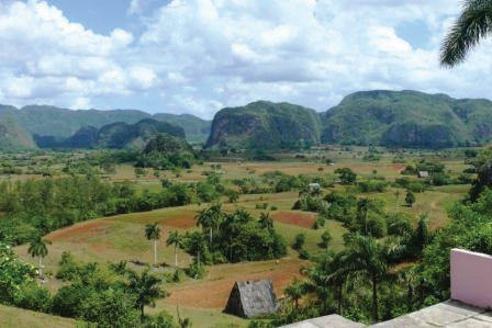
In 2008, Hurricanes Gustav and Ike devastated the tobacco crops, but the region is recovering and is a major tourist area.
The Commonwealth of Puerto Rico
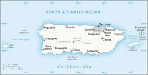
Map of Puerto Rico
Populated for centuries by Amerindian peoples, the island of Puerto Rico was claimed by the Spanish Crown in 1493, following Columbus’s second voyage to the Americas. In 1898, after 400 years of colonial rule, Puerto Rico was ceded to the United States as a result of the Spanish-American War. Puerto Ricans were granted US citizenship in 1917. Popularly elected governors have served since 1948. In 1952, a constitution was enacted providing for internal self-government. In elections held in 1967, 1993, and 1998, Puerto Rican voters chose to retain the commonwealth status, although they were almost evenly split between total independence and becoming a US state.
Puerto Rico is the smallest of the four islands of the Greater Antilles and is only slightly larger than the US state of Delaware. Puerto Rico’s population is about four million, similar to the population of Oregon. As US citizens, Puerto Ricans have no travel or employment restrictions anywhere in the United States, and about one million Puerto Ricans live in New York City alone. The commonwealth arrangement allows Puerto Ricans to be US citizens without paying federal income taxes, but they cannot vote in US presidential elections. The Puerto Rican Federal Relations Act governs the island and awards it considerable autonomy.
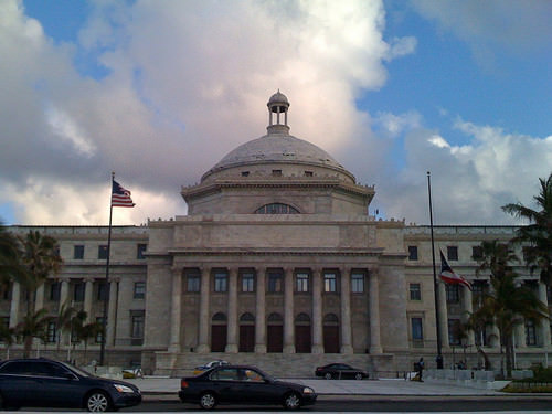
US Government Building in San Juan, Puerto Rico, with Both US and Puerto Rican Flags.
Puerto Rico has one of the most dynamic economies in the Caribbean Basin. However, about 60 percent of its population lives below the poverty line. A diverse industrial sector has surpassed agriculture as the primary area of economic activity. Encouraged by duty-free access to the United States and by tax incentives, US firms have invested heavily in Puerto Rico since the 1950s.
Sugar production has lost out to dairy production and other livestock products as the main source of income in the agricultural sector. Tourism has traditionally been an important source of income, with estimated arrivals of more than five million tourists a year. San Juan is the number one port for cruise ships in the Caribbean. The US government also subsidizes Puerto Rico’s economy with financial aid.
The future of Puerto Rico as a political unit remains unclear. Some in Puerto Rico want independence, and others would like to become the 51st US state. The commonwealth status is a compromise. Puerto Rico is not an independent country as a result of colonialism. Many of the islands and colonies in the Caribbean Basin have experienced dynamics similar to Puerto Rico in that they are still under the political jurisdiction of a country that colonized them.
The Dominican Republic
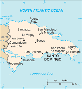
Map of the Dominican Republic
Sharing the island of Hispaniola are the two countries of the Dominican Republic and Haiti. The island became a possession of Spain under European colonialism after it was visited by Columbus in 1492 and 1493. The Tiano-Arawak people were nonviolent and welcomed the Europeans, who subjugated and enslaved them. French buccaneers settled on the western portion of Hispaniola and started growing tobacco and agricultural crops. France and Spain finally agreed to divide the island into two colonies. The western side would be French, and the eastern side would be Spanish.
The Dominican Republic holds the largest share of Hispaniola. A former Spanish colony, the Dominican Republic has weathered the storms of history to become a relatively stable democratic country. The Dominican Republic has long been viewed primarily as an exporter of sugar, coffee, and tobacco, but in recent years the service sector has overtaken agriculture as the economy’s largest employer.
The mountainous interior and the coastal beaches are attractive to the tourism market, and tourism remains the main source of economic income. The economy is highly dependent on the United States, which is the destination for nearly 60 percent of its exports. Remittances from workers in the United States sent back to their families on the island contribute much to the economy.
.jpg?revision=1) Punta Cana is a resort town in the easternmost province of the Dominican Republic.
Punta Cana is a resort town in the easternmost province of the Dominican Republic.The country suffers from marked income inequality. The poorest half of the population receives less than one-fifth of the gross domestic product (GDP), while the richest 10 percent enjoys nearly 40 percent of GDP. High unemployment and underemployment remain an important long-term challenge. The Central American-Dominican Republic Free Trade Agreement (CAFTA-DR) came into play in March 2007, boosting investment and exports and reducing losses to the Asian garment industry. In addition, the global economic downturn has hurt the Dominican Republic.
Plantation agriculture thrived in Haiti during the colonial era, producing sugar, coffee, and other cash crops. The local labor pool was insufficient to expand plantation operations, so French colonists brought in thousands of African slaves to work the plantations. People of African descent soon outnumbered Europeans. Haiti became one of the most profitable French colonies in the world with some of the highest sugar production of the time.
A slave revolt that began in 1792 finally defeated the French forces, and Haiti became an independent country in 1804. It was the first country ever to be ruled by former slaves. However, the transition to a fully functional free state was difficult. Racked by corruption and political conflicts, few presidents in the first 100 years ever served a full term in office.
Haiti
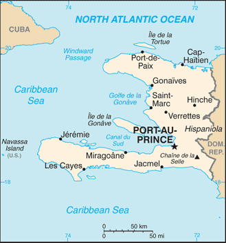
Map of Haiti
The United States occupied Haiti from 1915 to 1934 in an attempt to instill a US presence and bring some sense of stability. From 1957 to 1986, Dr. François “Papa Doc” Duvalier and then his son Jean-Claude “Baby Doc” Duvalier controlled the government. They created a private army and terrorist death squads known as Tonton Macoutes. Many Haitians fled to the United States or Canada, especially to French-speaking Quebec. After the Duvalier era, a Catholic priest by the name of Jean-Bertrand Aristide won the presidency through democratic elections only to be deposed of by a military coup a few years later. Haiti has had a difficult time finding political and economic stability.
Haiti is the poorest nation in the Western Hemisphere, and many Haitians live in dire poverty with few employment opportunities. An elite upper-class minority controls the bulk of the nation’s wealth. Many people in Haiti have sought comfort in Voodou (Voodoo), a religious practice steeped in African beliefs brought over with the slave trade. Often misunderstood by outsiders, Voodou’s main objective is to bring good health and well-being.
Haiti’s January 12, 2010 earthquake was a major setback for such a poor country that was already in need of aid and support. The 7.0 magnitude earthquake, with many aftershocks, struck Haiti about 15 miles from Port-Au-Prince, resulting in as many as 200,000 deaths. More than two million were immediately homeless, and about one million more were in need of aid. The lack of building standards in Haiti contributed to the collapse of structures and the devastation. Food and other aid were brought in by many international agencies and other countries to address the situation. Efforts continue to address the needs of the Haitian people to stabilize the situation and provide support and future opportunities.
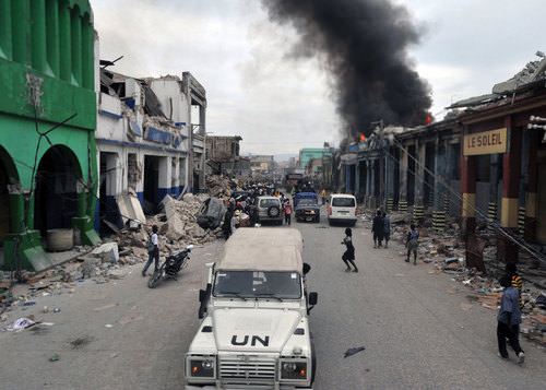
UN peacekeeping troops patrol the streets of Port au Prince after Haiti’s 2010 earthquake.
Jamaica
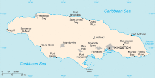
Map of Jamaica
The tropical island of Jamaica is physically smaller than the US state of Connecticut. In 2017, the estimated population was close to 3 million people. Jamaica was settled by the Spanish early in the 16th century. The Taino Indians, who had inhabited Jamaica for centuries, were gradually eradicated and replaced by African slaves. When England seized the island from Spain in 1655, it established a plantation economy based on sugar, cocoa, and coffee.
Two hundred years later (1834), the abolition of slavery freed about 250,000 slaves, many of whom became small farmers. Jamaica gradually obtained independence from Britain, with full independence achieved in 1962. Sugar, cocoa, and coffee production continue on the island. The Blue Mountains of eastern Jamaica are known for their Blue Mountain coffee production.
Deteriorating economic conditions during the 1970s led to recurrent violence as rival gangs affiliated with the major political parties evolved into powerful organized crime networks. These networks were involved in international drug smuggling and money laundering. Violent crime, drug trafficking, and poverty pose significant challenges to the country. Nonetheless, many rural and resort compounds remain safe and contribute substantially to the tourism sector. The beautiful beaches and lush interior make for an attractive destination for cruise ships and other tourists.
Tourism and Economic Activity in the Rimland
The physical geography of the Caribbean region makes it a prime location for tourism. Its beautiful coastal waters and warm tropical climate draw in tourists from all over North America and the world. Tourism is the number one means of economic income for many places in the Caribbean Basin, and the tourist industry has experienced enormous growth in the last few decades.
Tourism is a powerful force to achieve economic development for the people on the islands of the Lesser Antilles. In the last decade, there has been strong growth in the number of cruise ships operating in the Caribbean. Cruise ships from the southern coasts of the United States sail around the islands and coastal regions. San Juan receives the largest number of cruise ship travelers. Other areas well known to tourists include the Bahamas, St. Martin, and the Virgin Islands. Even the poorest country in the Caribbean, Haiti, has tried to attract cruise ships to its ports. The main restriction on cruise ship travel is the hurricane season, from June to November.
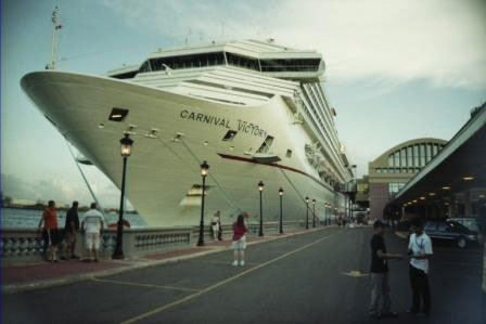
Large cruise ships in the Caribbean can hold up to 4,000 passengers and crew members. The major cruise lines do not operate in the Caribbean during hurricane season.
One might reasonably think that the economic benefits of tourism would be entirely positive. Even though tourism has become a vital economic component of the Caribbean Basin, in the long term, tourism creates many problems. Large cruise ships and pleasure crafts can overtax the environment. There have been occasions where there were actually more tourists than citizens on an island. An increase in tourist activity brings with it an increase in environmental pollution.
Most people in the Caribbean Basin live below the poverty line. The investment in tourism infrastructure, such as exclusive hotels and five-star resorts, takes away resources that could be allocated to schools, roads, medical clinics, and housing. However, without the income from tourism, there would be no money for infrastructure. Tourism attracts people who can afford to travel. Most of the jobs in hotels, ports, and restaurants where wealthy tourists visit employ people from poorer communities at low wages.
The disparity between the tourists and the workers creates strong centrifugal cultural dynamics. The gap between the level of affluence and the level of poverty is wide in the Caribbean. In the model of how countries gain wealth, tourism is a mixed-profit situation. Local businesses in the Caribbean do gain income from tourists who spend their money there. However, the big money is in the cruise ship lines and the resort hotels, which are mainly owned by international corporations or the local wealthy elite.
There is little activity in the Caribbean Basin in the manufacturing sector. Although US firms have invested in Puerto Rico, and the Dominican Republic has experienced growth in light industries and information technologies, the remaining islands have had little industrial growth. Unless an island state has natural resources such as oil or minerals, as is the case with Trinidad and Tobago, there are few opportunities other than tourism to bolster the economy.
Agricultural products have been traditionally a large part of the economic activity of the islands of the Lesser Antilles. Grenada is known for its nutmeg and other spices. Bananas, sugar, and other fruit and food crops have also been exported products. The problem has been that the profit margins on the products are low and prices are subject to international markets, which fluctuate widely. With an increasing population and few opportunities or advantages, countries such as Haiti suffer from poverty and unemployment. Being an island, there are few methods of expanding the economy. People often try to migrate to another county in search of employment and a more hopeful future.
Offshore Banking
Other methods of gaining wealth in the Caribbean include offshore banking and financial services. Various islands have established themselves as banking centers where one can set up financial accounts that are outside the jurisdiction of other countries. These offshore accounts provide tax havens for individuals or corporations that wish to evade taxes in their home countries. Many of these island banking centers do not share account information with tax agencies or government offices of other countries. Places such as the Cayman Islands have a worldwide reputation for professional financial services for offshore banking. As a result, the people of the Cayman Islands have a high standard of living with much national wealth.
The Bahamas and the Turks and Caicos have also established offshore financial centers. Other Caribbean Islands are working to increase their visibility with similar services. All are hoping to gain income from this low-impact and high-income enterprise. The United States and other countries have made attempts to pressure these islands to share the financial account information of people evading taxes. If successful, there may be less of an incentive for individuals and businesses to use offshore accounts to shelter income from taxes or for those involved in illegal money-laundering schemes to hide money in the Caribbean.
The wide level of diversity in the Caribbean has not made it easy for outside groups to provide support and assistance for common economic goals. The Caribbean Community (CARICOM) is an organization with 15 Caribbean members established to promote economic integration and cooperation in the region. It hopes to coordinate foreign policy for the region and ensure that the benefits of integration are equitably shared. CARICOM is an attempt to compete with other trade organizations such as NAFTA and CAFTA-DR.
Caribbean Music
The Caribbean culture includes many varieties of music that have developed on several islands. The region is a breeding ground for innovative music and rhythms that emulate the cultural traditions and attitudes of the people. Every island has its own traditional festivals that include parades, music, and dance. The music scene reveals the uniqueness of the Caribbean. Listening to the different sounds coming from the different islands showcases the cultural backgrounds found in the Caribbean.
The Caribbean is full of local musical variations, and many types of music are found only on a single island or two. For example, the Dominican Republic has meringue music, Dominica has bouyon, and Haiti has its festive rara music.
The Cuban influence on music is evident in the salsa tunes from the Caribbean over the years. African and Spanish cultural influences have helped shape the salsa music that has evolved from Cuba and neighboring islands of Puerto Rico and the Greater Antilles. With a strong percussion component, brass additions, and guitar sections, salsa has become popular throughout many parts of Latin America. Other genres of music coming out of Cuba include rumba, habanera, son, and timba, to name a few.
Calypso music comes from a mix of African influences on the island of Trinidad. Calypso began taking shape at the beginning of the 20th century and gained popularity through Carnival and other Caribbean festivals. It has evolved to incorporate the steel pan and other musical instruments. A commercial version of calypso became popular with Harry Belafonte’s version of the Jamaican folk tune of “Day-O,” known as the “Banana Boat Song." Mento is a more folksy rural style of acoustical music that influenced other forms of music such as reggae in Jamaica.
The steel pan is the national instrument of Trinidad and Tobago, where it was created. The pan was originally made from 55-gallon oil drums. The bottom is cut off at various levels to provide different sounds. The top is then shaped into a chromatically pitched percussion instrument. It is struck with a pair of straight sticks. An entire family of pans has been developed and can be assembled into a steel pan orchestra. The instrument has become popular outside the Caribbean as well.
Reggae music started coming out of Jamaica in the 1960s with the music of such artists as Bob Marley and the Wailers, which featured Peter Tosh and Bunny Wailer. The rhythmic style with offbeat accents evolved from earlier genres to become a standard of Jamaican music. Musicians from the Beatles to Eric Clapton have used reggae rhythms. Outside Jamaica, reggae has hit the charts thanks to groups such as UB40. Reggae music has often been associated with the Rastafarian movement or Rasta.
Tropical Hurricanes (Cyclones) in Middle America
Above the oceans just north and south of the equator, a weather phenomenon called a tropical cyclone. Once a tropical cyclone develops, it can drastically alter the physical and cultural landscape if it reaches land. In the North Atlantic Ocean and the Caribbean Sea, this weather pattern is called a hurricane. In the North Pacific Ocean, the same type of weather pattern is called a typhoon. In the Indian Ocean region and in the South Pacific Ocean, it is called a tropical cyclone or just a cyclone. All these storms are considered tropical because they almost always develop between the Tropics of Cancer and Capricorn.
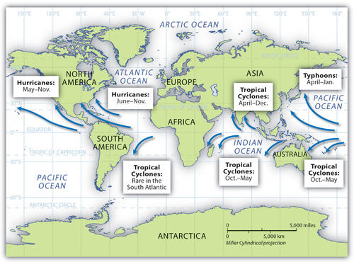
Cyclones, hurricanes, and typhoons and their respective locations around the world.
Hurricanes develop over water that is warmer than 80 ºF. As the air heats, it rises rapidly, drawing incoming air to replace the rising air and creating strong wind currents and storm conditions. The rapidly rising humid air then cools and condenses, resulting in heavy rains and a downdraft of cooler air. The rotation of the earth causes the storm to rotate in a cyclonic pattern. North of the equator, tropical storms rotate in a counterclockwise direction. South of the equator, tropical storms rotate in a clockwise direction.
Hurricanes start out as tropical depressions, which are storms with wind speeds between 25 and 38 miles per hour. Cyclonic motion and warm temperatures feed the system. If a storm reaches sustained winds of 39 to 73 miles per hour, it is upgraded to a tropical storm. Tropical depressions are numbered, and tropical storms are named. When winds reach a sustained speed of 74 miles per hour, a storm is classified as a hurricane.
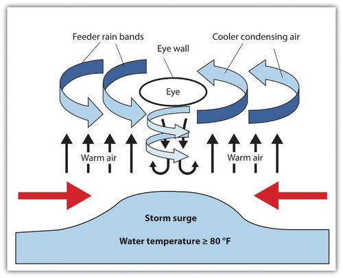
This graphic illustrates the dynamics of hurricane components.
- Colonialism created a high level of ethnic, linguistic, and economic diversity in the Caribbean. The main shifts were the demise of indigenous groups and the introduction of African slaves.
- The African influence can be witnessed in the religions of Santeria in Cuba, Voodoo in Haiti, and Rasta in Jamaica.
- The Caribbean Basin faces many challenges, including natural elements such as hurricanes, earthquakes, and volcanic activity.
- Economic conditions are often hampered by environmental degradation, corruption, organized crime, or the lack of employment opportunities.
- The Cuban Revolution led by Fidel Castro created a socialist state that nationalized foreign-owned assets and brought about a trade embargo by the United States.
- Cuba lost its aid from the Soviet Union after the USSR’s collapse in 1991 and has been increasing its focus on tourism and capitalistic reforms.
- Tourism can bring added economic income for an island country, but it also shifts to the service sector resources that are needed for infrastructure and services.
- A high percentage of tourism income goes to external corporations.
- The diversity of the Caribbean is evident in the wide range of musical types generated from the islands.
- Individual islands are known for certain types of music; salsa, reggae, and calypso are examples.
- Tropical cyclones occur in the tropical regions over warm ocean water. In the North Atlantic, they are called hurricanes; in the North Pacific, they are called typhoons; and in the Indian Ocean, they are called cyclones.
Vocabulary Terms
- Archipelago: A group or chain of islands
- Greater Antilles: is a grouping of the larger islands in the Caribbean Sea: Cuba, Hispaniola (containing Haiti and the Dominican Republic), Puerto Rico, Jamaica
- Hurricane: A storm that forms over warm, tropical ocean waters. Starts off as a tropical storm. Brings heavy rain and winds that exceed 75 miles per hour.
- Lesser Antilles: a long arc of small islands in the Eastern Caribbean Sea extending in a north-south direction from the Virgin Islands to Grenada
- Saffir-Simpson Scale: Hurricane rating scale from 1-5. category 5 being most dangerous
- US Embargo on Cuba: The official ban on trade or other commercial activity with Cuba, which was imposed in the late 1950s
Interactive Notebook Activities
Applying Knowledge
- Describe how the physical environment has affected human activity in the region.
- Summarize in a few sentences the various ways in which colonialism has impacted the islands.
- Explain why the United States has an economic embargo against the socialist country of Cuba.
- Explain how tourism has become the main means of economic development for most of the Caribbean.
- Identify and list the main music genres that have emerged from the Caribbean.
- Describe how and why hurricanes form.
- Explain why hurricanes mainly occur in the tropics.
- Summarize briefly why hurricanes have the potential to be so dangerous.
Discussion and Study Questions
- Which islands make up the Greater Antilles? Where are the Lesser Antilles?
- Which European countries were the main colonizers of the Caribbean?
- How is Cuba a good example of a rimland country?
- Why does the United States still have an economic embargo against Cuba?
- How is the political system in Cuba different from that of the United States?
- Why is Puerto Rico a commonwealth of the United States?
- How is Haiti different from its neighbor, the Dominican Republic?
- What are the positive and negative perspectives on the Caribbean tourism industry?
- Besides tourism, what other methods do people in the Caribbean islands use to generate wealth?
- How do differences in musical styles tell a story of Caribbean culture?
Real-World Geography Exercise
Using Google Maps, locate the places below. Using the Internet, research to find a picture and a fact about each place. To which region would you like to travel? Why? Be prepared to share your answers.
- The Bahamas
- Blue Mountains
- Greater Antilles
- Lesser Antilles
- Sierra Maestra
- Viñales Valley
Mapping Exercise
Borders, Boundaries, and Barriers; Students will learn examples of boundaries, borders, and barriers around the world that exhibit the organization of the earth’s surface as identified through political geography. The activity uses a web-based map.
Videos for Geography Enrichment
Helpful Websites for the Study of Geography
Canadian Encyclopedia is an encyclopedia funded by the Canadian government covering all branches of knowledge. Their scholarly collection includes interactive materials.
CIA World Factbook provides information on the people, history, government, economy, energy, geography, communications, transportation, military, and transnational issues for the world's entities.
Congress.gov is a US government website where you can find federal legislation, past and present, as well as information about the US legal system.
Drug Enforcement Administration (DEA) is a government agency website that provides current news, resources, topics of interest, information about drugs, careers in the DEA, and a tip hotline.
Library of Congress is the largest library in the world and provides manuscripts, files, information, pictures, and videos.
NASA Earth Observatory (NEO) is a US government agency website that allows users to search for and retrieve satellite images of Earth.
National Archives is a US government website that provides historical documents, photos, records, publications, and educator resources.
National Oceanic and Atmospheric Association (NOAA) is a US government agency website that provides weather-related information and ocean research.
National Map is a website by the United States Geological Survey and other federal, state, and local agencies that deliver topographic information for the United States.
NationMaster is a massive central data source and a handy way to graphically compare nations.
Real-Time World Air Quality Index is a website that measures most locations in the world for air pollution in real time.
StateMaster is a unique statistical database, which allows you to research and compare a multitude of different data on US states.
United Nations (UN) is an international organization founded in 1945 and made up of 193 member states. The UN maintains international peace and security, protects human rights, delivers humanitarian aid, promotes sustainable development, and upholds international law.
United States Census Bureau is a US government agency that provides a population clock, data, surveys, statistics, a library with information and infographics, news about the economy, and much more.
United States Geological Survey (USGS) is a US government agency website that provides scientific information about the natural hazards that threaten lives, the natural resources we rely on, the health of our ecosystems and environment, and the impacts of climate and land-use change.
Whitehouse.gov is a US government website that provides the latest presidential news, information about the budget, policy, defense, and many more topics.
World Health Organization (WHO) is under the United Nations and provides leadership on matters critical to health, shapes the research agenda on health, and monitors the health situation and assessing health trends around the world. Their website provides information on the state of health around the world, outbreaks, current health news, and more.
World Trade Organization (WTO) is an intergovernmental organization that regulates international trade. The website provides information on the history of the multilateral trading system, featured videos, news and events, trade topics, and more.
| Image | Reference | Attributions |
 |
[Figure 1] | Credit: http://open.lib.umn.edu/worldgeograp...the-caribbean/ Source: open.lib.umn.edu/worldgeography/wp-content/uploads/sites/181/2016/04/32ac72b9554942a4f7564f9aeb4c6a0f.jpg License: CC BY-NC 3.0 |
 |
[Figure 2] | Credit: cia world factbook Source: https://www.cia.gov/library/publications/the-world-factbook/geos/cu.html License: CC BY-NC 3.0 |
 |
[Figure 3] | Credit: http://open.lib.umn.edu/worldgeograp...the-caribbean/ Source: open.lib.umn.edu/worldgeography/wp-content/uploads/sites/181/2016/04/8e175fe18eb8a9d7a9a82d5ac80eedfd.jpg License: CC BY-NC 3.0 |
 |
[Figure 4] | Credit: Wikimedia Commons – CC BY 3.0; R. Berglee – CC BY-NC-SA. Source: open.lib.umn.edu/worldgeography/wp-content/uploads/sites/181/2016/04/f4203298e42c7c4a9eec8c30d4154775.jpg License: CC BY-NC 3.0 |
 |
[Figure 5] | Credit: Photo by R. Berglee – CC BY-NC-SA. Source: open.lib.umn.edu/worldgeography/wp-content/uploads/sites/181/2016/04/1b85c7048d75b8c2565f59f4ef1676fd.jpg License: CC BY-NC 3.0 |
 |
[Figure 6] | Credit: Photo by R. Berglee – CC BY-NC-SA. Source: open.lib.umn.edu/worldgeography/wp-content/uploads/sites/181/2016/04/f8aedc7596e02d33cbc7ca3d64280adf.jpg License: CC BY-NC 3.0 |
 |
[Figure 7] | Credit: cia world factbook Source: https://www.cia.gov/library/publications/the-world-factbook/geos/rq.html License: CC BY-NC 3.0 |
 |
[Figure 8] | Credit: Rafael Torres – Puerto Rico Capitol Building – CC BY-NC-ND 2.0. Source: http://open.lib.umn.edu/worldgeography/chapter/5-4-the-caribbean/ License: CC BY-NC 3.0 |
 |
[Figure 9] | Credit: cia world factbook Source: https://www.cia.gov/library/publications/the-world-factbook/geos/dr.html License: CC BY-NC 3.0 |
 |
[Figure 11] | Credit: cia world factbook Source: https://www.cia.gov/library/publications/the-world-factbook/geos/ha.html License: CC BY-NC 3.0 |
 |
[Figure 12] | Credit: Wikimedia Commons – CC BY 2.5. Source: open.lib.umn.edu/worldgeography/wp-content/uploads/sites/181/2016/04/cb3d7b19782dda2651ac67cea290c750.jpg License: CC BY-NC 3.0 |
 |
[Figure 13] | Credit: cia world factbook Source: https://www.cia.gov/library/publications/the-world-factbook/geos/jm.html License: CC BY-NC 3.0 |
 |
[Figure 14] | Credit: Photo by R. Berglee – CC BY-NC-SA. Source: open.lib.umn.edu/worldgeography/wp-content/uploads/sites/181/2016/04/92015955e0d934783833c67ae5b7284c.jpg License: CC BY-NC 3.0 |
 |
[Figure 15] | Credit: open.lib.umn.edu/worldgeograp...es-hurricanes/ Source: open.lib.umn.edu/worldgeography/wp-content/uploads/sites/181/2016/04/d245bfe474b6b320cfd52bfd234f0fca.jpg License: CC BY-NC 3.0 |
 |
[Figure 16] | Credit: http://open.lib.umn.edu/worldgeograp...es-hurricanes/ Source: open.lib.umn.edu/worldgeography/wp-content/uploads/sites/181/2016/04/d4c2b42d4b5391ef9a44e27eb0dcde54.jpg License: CC BY-NC 3.0 |

