
6.1: Russia- Physical Characteristics (2 Days)
- Page ID
- 1889
\( \newcommand{\vecs}[1]{\overset { \scriptstyle \rightharpoonup} {\mathbf{#1}} } \)
\( \newcommand{\vecd}[1]{\overset{-\!-\!\rightharpoonup}{\vphantom{a}\smash {#1}}} \)
\( \newcommand{\id}{\mathrm{id}}\) \( \newcommand{\Span}{\mathrm{span}}\)
( \newcommand{\kernel}{\mathrm{null}\,}\) \( \newcommand{\range}{\mathrm{range}\,}\)
\( \newcommand{\RealPart}{\mathrm{Re}}\) \( \newcommand{\ImaginaryPart}{\mathrm{Im}}\)
\( \newcommand{\Argument}{\mathrm{Arg}}\) \( \newcommand{\norm}[1]{\| #1 \|}\)
\( \newcommand{\inner}[2]{\langle #1, #2 \rangle}\)
\( \newcommand{\Span}{\mathrm{span}}\)
\( \newcommand{\id}{\mathrm{id}}\)
\( \newcommand{\Span}{\mathrm{span}}\)
\( \newcommand{\kernel}{\mathrm{null}\,}\)
\( \newcommand{\range}{\mathrm{range}\,}\)
\( \newcommand{\RealPart}{\mathrm{Re}}\)
\( \newcommand{\ImaginaryPart}{\mathrm{Im}}\)
\( \newcommand{\Argument}{\mathrm{Arg}}\)
\( \newcommand{\norm}[1]{\| #1 \|}\)
\( \newcommand{\inner}[2]{\langle #1, #2 \rangle}\)
\( \newcommand{\Span}{\mathrm{span}}\) \( \newcommand{\AA}{\unicode[.8,0]{x212B}}\)
\( \newcommand{\vectorA}[1]{\vec{#1}} % arrow\)
\( \newcommand{\vectorAt}[1]{\vec{\text{#1}}} % arrow\)
\( \newcommand{\vectorB}[1]{\overset { \scriptstyle \rightharpoonup} {\mathbf{#1}} } \)
\( \newcommand{\vectorC}[1]{\textbf{#1}} \)
\( \newcommand{\vectorD}[1]{\overrightarrow{#1}} \)
\( \newcommand{\vectorDt}[1]{\overrightarrow{\text{#1}}} \)
\( \newcommand{\vectE}[1]{\overset{-\!-\!\rightharpoonup}{\vphantom{a}\smash{\mathbf {#1}}}} \)
\( \newcommand{\vecs}[1]{\overset { \scriptstyle \rightharpoonup} {\mathbf{#1}} } \)
\( \newcommand{\vecd}[1]{\overset{-\!-\!\rightharpoonup}{\vphantom{a}\smash {#1}}} \)
\(\newcommand{\avec}{\mathbf a}\) \(\newcommand{\bvec}{\mathbf b}\) \(\newcommand{\cvec}{\mathbf c}\) \(\newcommand{\dvec}{\mathbf d}\) \(\newcommand{\dtil}{\widetilde{\mathbf d}}\) \(\newcommand{\evec}{\mathbf e}\) \(\newcommand{\fvec}{\mathbf f}\) \(\newcommand{\nvec}{\mathbf n}\) \(\newcommand{\pvec}{\mathbf p}\) \(\newcommand{\qvec}{\mathbf q}\) \(\newcommand{\svec}{\mathbf s}\) \(\newcommand{\tvec}{\mathbf t}\) \(\newcommand{\uvec}{\mathbf u}\) \(\newcommand{\vvec}{\mathbf v}\) \(\newcommand{\wvec}{\mathbf w}\) \(\newcommand{\xvec}{\mathbf x}\) \(\newcommand{\yvec}{\mathbf y}\) \(\newcommand{\zvec}{\mathbf z}\) \(\newcommand{\rvec}{\mathbf r}\) \(\newcommand{\mvec}{\mathbf m}\) \(\newcommand{\zerovec}{\mathbf 0}\) \(\newcommand{\onevec}{\mathbf 1}\) \(\newcommand{\real}{\mathbb R}\) \(\newcommand{\twovec}[2]{\left[\begin{array}{r}#1 \\ #2 \end{array}\right]}\) \(\newcommand{\ctwovec}[2]{\left[\begin{array}{c}#1 \\ #2 \end{array}\right]}\) \(\newcommand{\threevec}[3]{\left[\begin{array}{r}#1 \\ #2 \\ #3 \end{array}\right]}\) \(\newcommand{\cthreevec}[3]{\left[\begin{array}{c}#1 \\ #2 \\ #3 \end{array}\right]}\) \(\newcommand{\fourvec}[4]{\left[\begin{array}{r}#1 \\ #2 \\ #3 \\ #4 \end{array}\right]}\) \(\newcommand{\cfourvec}[4]{\left[\begin{array}{c}#1 \\ #2 \\ #3 \\ #4 \end{array}\right]}\) \(\newcommand{\fivevec}[5]{\left[\begin{array}{r}#1 \\ #2 \\ #3 \\ #4 \\ #5 \\ \end{array}\right]}\) \(\newcommand{\cfivevec}[5]{\left[\begin{array}{c}#1 \\ #2 \\ #3 \\ #4 \\ #5 \\ \end{array}\right]}\) \(\newcommand{\mattwo}[4]{\left[\begin{array}{rr}#1 \amp #2 \\ #3 \amp #4 \\ \end{array}\right]}\) \(\newcommand{\laspan}[1]{\text{Span}\{#1\}}\) \(\newcommand{\bcal}{\cal B}\) \(\newcommand{\ccal}{\cal C}\) \(\newcommand{\scal}{\cal S}\) \(\newcommand{\wcal}{\cal W}\) \(\newcommand{\ecal}{\cal E}\) \(\newcommand{\coords}[2]{\left\{#1\right\}_{#2}}\) \(\newcommand{\gray}[1]{\color{gray}{#1}}\) \(\newcommand{\lgray}[1]{\color{lightgray}{#1}}\) \(\newcommand{\rank}{\operatorname{rank}}\) \(\newcommand{\row}{\text{Row}}\) \(\newcommand{\col}{\text{Col}}\) \(\renewcommand{\row}{\text{Row}}\) \(\newcommand{\nul}{\text{Nul}}\) \(\newcommand{\var}{\text{Var}}\) \(\newcommand{\corr}{\text{corr}}\) \(\newcommand{\len}[1]{\left|#1\right|}\) \(\newcommand{\bbar}{\overline{\bvec}}\) \(\newcommand{\bhat}{\widehat{\bvec}}\) \(\newcommand{\bperp}{\bvec^\perp}\) \(\newcommand{\xhat}{\widehat{\xvec}}\) \(\newcommand{\vhat}{\widehat{\vvec}}\) \(\newcommand{\uhat}{\widehat{\uvec}}\) \(\newcommand{\what}{\widehat{\wvec}}\) \(\newcommand{\Sighat}{\widehat{\Sigma}}\) \(\newcommand{\lt}{<}\) \(\newcommand{\gt}{>}\) \(\newcommand{\amp}{&}\) \(\definecolor{fillinmathshade}{gray}{0.9}\)- Identify Russia’s climatic influences and physical regions.
- Determine how the czars expanded their territorial power to create the Russian Empire.
- Contrast the ways that the governments of the Russian Empire and the Soviet Union dealt with the issue of diverse nationalities within their countries.
- Describe some of the environmental problems facing the Russian republics today.
TEKS Regional Unit 06: Russia, the Caucasus and Central Asia; Chapter 6.1 Physical Characteristics.
WG.1A Describe the forces that determine the distribution of goods and services in free enterprise, socialist, and communist economic systems.
WG.10B Classify where specific countries fall along the economic spectrum between free enterprise and communism.
WG.10C Compare the ways people satisfy their basic needs through the production of goods and services such as subsistence agriculture versus commercial agriculture or cottage industries versus commercial industries.
WG.12A Analyze how the creation, distribution, and management of key natural resources affects the location and patterns of movement of products, money, and people.
WG.13A Interpret maps to explain the division of land, including man-made and natural borders, into separate political units such as cities, states, or countries.
WG.14A Analyze current events to infer the physical and human processes that lead to the formation of boundaries and other political divisions.
WG.17A Describe and Compare patterns of culture such as language, religion, land use, education, and customs that make specific regions of the world distinctive.
WG.18A Analyze cultural changes in specific regions caused by migration, war, trade, innovations, and diffusion.
WG.19C Examine the environmental, economic, and social impacts of advances in technology on agriculture and natural resources.
WG.21C Create and Interpret different types of maps to answer geographic questions, infer relationships, and analyze change.
WG.22B Generate summaries, generalizations, and thesis statements supported by evidence.
WG.22C Use geographic terminology correctly.
WG.22D Use standard grammar, spelling, sentence structure, and punctuation.
Physical Characteristics of Russia
The massive expanse of Russia exhibits a variety of physical environments, such as tundras, steppes, mountains, and birch forests. Type D (continental) climates dominate most of the country and characterize large landmasses such as Eurasia and North America. Land in the center of a large continent, far from the moderating effects of oceans, tends to heat up rapidly in the summer and cool down rapidly in the winter. These areas are known for hot summers and cold, harsh winters.
Northern Russia borders the Arctic Ocean, and frigid air masses from the Arctic swoop south across Russia each winter. Moreover, Russia’s northerly latitude means that it experiences a short growing season and has never been an agricultural superpower. The country usually has to import grain to feed its people. Mountain ranges to the south block summer rains and warm air masses that would otherwise come from South and Central Asia, thus creating deserts and steppes in southern Russia.
Most of Russia’s population live in the European part of the country on the Eastern European Plain, also known as the Western Russian Plain or the Russian Plain. It is the most agriculturally productive land in Russia. The eastern edge of the plain is marked by the Ural Mountains, a low-lying mountain chain (about 6,000 feet) that crosses Russia from the Arctic Ocean to Kazakhstan. The mountains contain deposits of coal, iron ore, and precious and semiprecious stones and are considered the boundary between Europe and Asia.
To the south of the Russian Plain is another mountain range, the Caucasus Mountains, which bridge the gap between the Caspian and Black Seas. East of the Urals are the West Siberian Plain, the Central Siberian Plateau, the Yakutsk Basin, the Eastern Highlands, and the Central Asian Ranges. Russia has rich natural resources, such as petroleum, natural gas, and forest products.
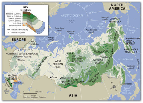 This map illustrates the physical regions of Russia.
Expansion of the Empire
The territory that makes up the Russian Federation was gradually conquered by the Russian Empire as the country expanded from its political core around Moscow/St. Petersburg during the 16th through the 19th centuries. By the end of the 18th century, Czarina Catherine the Great had expanded Russia to include the area that is now Ukraine, the northern Caucasus Mountains, and Alaska.
During the next century, the Russian Empire expanded eastward into Central Asia (what is now Kazakhstan, Uzbekistan, and the other Central Asian republics), southward into the rest of the Caucasus region, and westward into Poland and Finland. In the 20th century, when the Russian Empire disintegrated and was replaced by the Soviet Union (the Union of Soviet Socialist Republics or USSR), the central government continued to expand and strengthen its control of the vast area from Eastern Europe to the Pacific Ocean.
Both the Russian Empire and the Soviet Union were imperial powers. In other words, these governments ruled a large variety of ethnic groups in distant places. These places included people who spoke many languages, people who worshiped different gods in different ways, people who had various skin and hair colors, and people who did not consider themselves to be Russian. Russia had the largest empire in the world in terms of territory. Ruling this diverse, immense empire was an incredible challenge.
The czars ruled this empire with Russification and the sword. Russification refers to the attempt to minimize cultural differences and turn all Russian subjects into Russians, or at least to make them as Russian as possible. As they were all subject to the Russian czars, people were taught the Russian language and were encouraged to convert to Russian Orthodoxy. Russification was not very successful, and the farther people were from Moscow the less likely they were to be Russified. When the Soviets took over the Russian Empire, millions of Muslims still lived in Central Asia, on the Crimean peninsula of southern Ukraine, in the Caucasus Mountains, and elsewhere.
The Soviets took a different approach when it came to unifying the diversity of the empire. Instead of emphasizing unity under the Russian czar, the Russian language, and the Russian Orthodox religion, the Soviets decided to organize the diversity of ethnic groups found in the Soviet Union. They chose some of the major groups and established Soviet Socialist Republics that corresponded to these major groups.
The following are the groups that were created:
- Uzbek Soviet Socialist Republic (Uzbek SSR)
- Kazakh Soviet Socialist Republic (Kazakh SSR)
- Ukrainian Soviet Socialist Republic (Ukrainian SSR)
- A different republic for each of the 14 ethnic groups
- Russian Soviet Federative Socialist Republic
About 85 other ethnic groups were not given their own republics, although some of them were allocated regions within the Russian Republic. In theory, each of the Soviet Socialist Republics was an independent state choosing to ally with the Soviet Union. In practice, these republics were part of a totalitarian, centrally ruled state with far fewer autonomous rights than states in the United States.
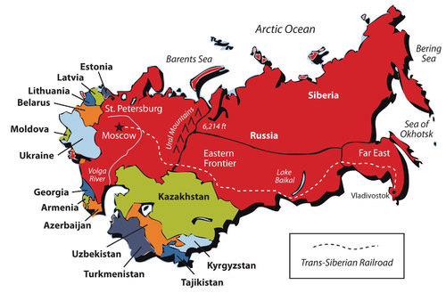 This map illustrates the former Soviet Union.
The creation of these republics strengthened certain ethnic/national identities and weakened others. There had not been a fully developed Uzbek national identity before the formation of the Uzbek SSR. The same was true for the Kazakh SSR, the Turkmen SSR, and others. Although people in a certain area might have spoken the same language, they did not think of themselves as belonging to a nation of fellow Uzbeks, Kazakhs, or Turkmen until they were put into one by the Soviet rulers. In 1991, when the Soviet Union collapsed, these Soviet Socialist Republics were able to declare their independence from Russia.
At the same time that the Soviets were organizing minority ethnic groups into republics, they were also sending ethnic Russians to live in non-Russian parts of the Soviet Union. Some were sent by force—such as Russians who were sent to prison camps in Siberia and stayed in the area after they were eventually freed. Other Russians were sent around the empire to work in factories, power plants, and other industries. Some were sent to help administer the government. By sending Russians to the far reaches of the Soviet Union, the Russian government hoped to consolidate its control over the various republics and to dilute the strength of the minority ethnicities.
This policy also had unintended consequences. When the Soviet Union collapsed after 1991 and the various republics became independent countries, they each had to deal with sizable Russian minorities. For example, at the time of its independence, nearly as many ethnic Russians lived in Kazakhstan (38 percent) as ethnic Kazakhs (40 percent). In the 20 years since then, many Russians moved to Russia from the former Soviet republics. In 2010, Kazakhstan’s population was only about 24 percent ethnic Russian.
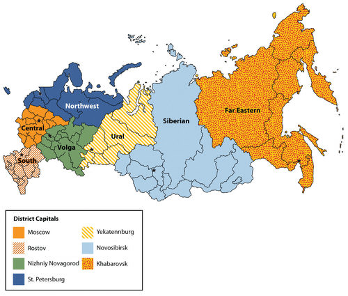 This map illustrates the new Russian federal districts.
The Russian federation was created with 83 federal subjects:
- 2 autonomous federal cities
- 46 provinces (oblasts)
- 9 territories (krais)
- 21 republics
- 4 autonomous districts (okrugs)
- 1 autonomous oblast
- Moscow and St. Petersburg are the two federal cities that function as their own units
The oblasts and krais each have a governor appointed by the central government and a locally elected legislature. The governorship was an elected position in the 1990s, but President Vladimir Putin changed the structure to strengthen the power of the central state.
The republics, designed to be home to certain ethnic minorities, are allowed to have their own constitutions and governments and to select an official language that will be used besides Russian. They are not considered independent countries with the right to secession.
The autonomous districts were also formed for ethnic minorities and are administered either by the central state or by the province or territory in which they are located. The only autonomous oblast was created in the 1930s to be a home for Jews in the Russian Far East, but only about one percent of the population remains Jewish today.
Regional Environmental Problems
Each region of the Russian republic has its own environmental issues. The core region surrounding Moscow, with all its industrial activity and large urban expanses, introduces sewage and chemicals to the country’s waterways, contributing to serious water pollution. The same water pollution is found east of the Ural Mountains—and in the waterways in that region—because of the industrial cities found there.
Moscow and the ring of industrial cities surrounding it have seen a dramatic increase in automobile use since 1991, contributing to air pollution. Russia has abundant natural resources, but significant environmental damage has been the price of exploiting and extracting those resources. Massive oil spills have occurred in the taiga and tundra areas, where the lack of safety management has increased environmental damage during oil exploration and development.
The taiga is the large expanse of evergreen or boreal forests in the north just south of the tundra in North America, Europe, and Asia. The taiga is most common in type D climates and is one of the largest biomes on earth. The taiga is the largest biome in Russia. Mining and smelting processes in Siberian cities have added to the region’s air and water pollution. These ecosystems are fragile and will take years to recover from such damage.
Water pollution from the rivers extends into the Black Sea, the Caspian Sea, and other bodies of water. Lake Baikal, described as the largest freshwater lake in the world, was at one time pristine, but pollutants have entered its waters from nearby industrial activity. Increased pollution in the Black and Caspian Seas, as well as overfishing, the lack of fishing regulations, and the lack of law enforcement have resulted in the devastation of fish populations such as the caviar-producing sturgeon.
The Arctic waters of the Barents Sea off the northern coast of Russia have been a dumping ground for nuclear waste products and expended nuclear reactors from naval vessels. The consequences of this nuclear pollution are not widely known or studied. Many additional aging nuclear reactors from the Soviet era dot the landscape, and they will need to be decommissioned at some point, adding to the nuclear waste issues. Various regions in Siberia were used for nuclear testing and are also contaminated with nuclear radiation.
- Russia’s climate is characterized by long, cold winters and short summers.
- Because of a short growing season, the country has such poor agriculture that usually it needs to import grain.
- The Russian Empire gradually expanded its territory to the east, west, and south of Moscow. By the end of the 19th century had accumulated a vast area of land and a great variety of people of many ethnicities, languages, and religions.
- The Soviets sent ethnic Russians across the Union of Soviet Socialist Republics (USSR) to better control and govern the territory and its people.
- When the Soviet Union collapsed, its internal nationality-oriented republics declared independence, and the Russians who had been sent to live around the USSR were now living in non-Russian countries. While most of the ethnic Russians stayed in their current countries, many others returned to Russia after 1991.
Vocabulary Terms
| chernozem | black topsoil, one of the world's richest soils found in Ukraine and into Russia |
| continentality | a region's distance from the moderating influence of the sea |
| Siberia | the Arctic and subarctic region of central Asia that extends from the Ural Mountains to the Pacific Ocean |
| taiga | a vast forest belt that covers about 40% of European Russia and extends into much of Siberia. It is the world's largest coniferous forest, containing about 50% of the world's softwood timber |
| tundra | a vast treeless plain in the arctic region of Russia between the ice cap and the tree line |
| Ural Mountains | the mountain ranges that separate the Northern European and West Siberian Plains and used as the dividing line between Europe and Asia |
| Volga River | longest river in Europe and connects Moscow to the Caspian Sea |
| Taiga | coniferous evergreen forest located in subarctic climate regions |
| Permafrost | area of subsoil that remains frozen |
| Crossroads | place where many migration routes intersect |
Applying Knowledge
Discussion and Study Questions
- What physical feature provides a divide between European and Asian Russia?
- What are Russia’s main physical regions?
- In what ways was Russia a colonial empire?
- What strategies did the Russian Empire use to govern a multiethnic state?
- What were Soviet Socialist Republics, and why were they created?
- What was a long-term consequence of the formation of Soviet Socialist Republics for the current geopolitical organization of this world region?
- What are some of the major environmental problems in Russia?
- Why did so many of the Soviet republics separate and become independent in 1991?
- Why wasn’t the Russian Orthodox Church more prominent or powerful during the Soviet era?
- Why do more people live on the smaller European side of Russia than the larger Asian side?
Real-World Geography Exercise
- Using Google Maps, complete the following activities:
- Locate each place on the bulleted list below.
- Find the nearest city with an international airport in proximity to each location on the bulleted list below.
- Calculate the distance and travel time by plane to each city from the Baltimore-Washington International Airport in Baltimore, Maryland.
- Using NASA Latitude and Longitude Finder, determine the latitude and longitude for each location on the bulleted list below.
- Be prepared to share and discuss your answers.
- Barents Sea
- Black Sea
- Caspian Sea
- Caucasus Mountains
- Central Asian Ranges
- Central Siberian Plateau
- Eastern Highlands
- European Plain
- Lake Baikal
- Ural Mountains
- West Siberian Plain
- Yakutsk Basin
Mapping Exercise
Russian Expansion to the Sea: Discover when and how Russia acquired territory between 1553 and 1914 to become the largest country in the world. This mapping exercise uses online mapping software.
Helpful Websites for the Study of Geography
Canadian Encyclopedia is an encyclopedia funded by the Canadian government covering all branches of knowledge. Their scholarly collection includes interactive materials.
CIA World Factbook provides information on the people, history, government, economy, energy, geography, communications, transportation, military, and transnational issues for the world's entities.
Congress.gov is a US government website where you can find federal legislation, past and present, as well as information about the US legal system.
Drug Enforcement Administration (DEA) is a government agency website that provides current news, resources, topics of interest, information about drugs, careers in the DEA, and a tip hotline.
Library of Congress is the largest library in the world and provides manuscripts, files, information, pictures, and videos.
NASA Earth Observatory (NEO) is a US government agency website that allows users to search for and retrieve satellite images of Earth.
National Archives is a US government website that provides historical documents, photos, records, publications, and educator resources.
National Oceanic and Atmospheric Association (NOAA) is a US government agency website that provides weather-related information and ocean research.
National Map is a website by the United States Geological Survey and other federal, state, and local agencies that delivers topographic information for the United States.
NationMaster is a massive central data source and a handy way to graphically compare nations.
Real-Time World Air Quality Index is a website that measures most locations in the world for air pollution in real time.
StateMaster is a unique statistical database, which allows you to research and compare a multitude of different data on US states.
United Nations (UN) is an international organization founded in 1945 and made up of 193 member states. The UN maintains international peace and security, protects human rights, delivers humanitarian aid, promotes sustainable development, and upholds international law.
United States Census Bureau is a US government agency that provides a population clock, data, surveys, statistics, a library with information and infographics, news about the economy, and much more.
United States Geological Survey (USGS) is a US government agency website that provides scientific information about the natural hazards that threaten lives, the natural resources we rely on, the health of our ecosystems and environment, and the impacts of climate and land-use change.
Whitehouse.gov is a US government website that provides the latest presidential news, information about the budget, policy, defense, and many more topics.
World Health Organization (WHO) is under the United Nations and provides leadership on matters critical to health, shapes the research agenda on health, and monitors the health situation and assessing health trends around the world. Their website provides information on the state of health around the world, outbreaks, current health news, and more.
World Trade Organization (WTO) is an intergovernmental organization that regulates international trade. The website provides information on the history of the multilateral trading system, featured videos, news and events, trade topics, and more.
Discover when and how Russia acquired territory between 1553 and 1914 to become the largest country in the world.
| Image | Reference | Attributions |
|
[Figure 1] | Credit: cia world factbook Source: open.lib.umn.edu/worldgeography/wp-content/uploads/sites/181/2016/04/b9b3e18f588bf4b23aa9e413a21cef7a.jpg License: CC BY-NC 3.0 |
|
[Figure 2] | Credit: http://open.lib.umn.edu/worldgeograp...ing-the-realm/ Source: open.lib.umn.edu/worldgeography/wp-content/uploads/sites/181/2016/04/884cd790424556169985cdfb3e4053bd.jpg License: CC BY-NC 3.0 |
|
[Figure 3] | Credit: Wikimedia Commons – CC BY 2.5. Source: open.lib.umn.edu/worldgeography/wp-content/uploads/sites/181/2016/04/4e084f74e12a1781e728ab96e52cba9a.jpg License: CC BY-NC 3.0 |