
9.1: South Asia- Introducing the Realm (2 Days)
- Page ID
- 1981
\( \newcommand{\vecs}[1]{\overset { \scriptstyle \rightharpoonup} {\mathbf{#1}} } \)
\( \newcommand{\vecd}[1]{\overset{-\!-\!\rightharpoonup}{\vphantom{a}\smash {#1}}} \)
\( \newcommand{\id}{\mathrm{id}}\) \( \newcommand{\Span}{\mathrm{span}}\)
( \newcommand{\kernel}{\mathrm{null}\,}\) \( \newcommand{\range}{\mathrm{range}\,}\)
\( \newcommand{\RealPart}{\mathrm{Re}}\) \( \newcommand{\ImaginaryPart}{\mathrm{Im}}\)
\( \newcommand{\Argument}{\mathrm{Arg}}\) \( \newcommand{\norm}[1]{\| #1 \|}\)
\( \newcommand{\inner}[2]{\langle #1, #2 \rangle}\)
\( \newcommand{\Span}{\mathrm{span}}\)
\( \newcommand{\id}{\mathrm{id}}\)
\( \newcommand{\Span}{\mathrm{span}}\)
\( \newcommand{\kernel}{\mathrm{null}\,}\)
\( \newcommand{\range}{\mathrm{range}\,}\)
\( \newcommand{\RealPart}{\mathrm{Re}}\)
\( \newcommand{\ImaginaryPart}{\mathrm{Im}}\)
\( \newcommand{\Argument}{\mathrm{Arg}}\)
\( \newcommand{\norm}[1]{\| #1 \|}\)
\( \newcommand{\inner}[2]{\langle #1, #2 \rangle}\)
\( \newcommand{\Span}{\mathrm{span}}\) \( \newcommand{\AA}{\unicode[.8,0]{x212B}}\)
\( \newcommand{\vectorA}[1]{\vec{#1}} % arrow\)
\( \newcommand{\vectorAt}[1]{\vec{\text{#1}}} % arrow\)
\( \newcommand{\vectorB}[1]{\overset { \scriptstyle \rightharpoonup} {\mathbf{#1}} } \)
\( \newcommand{\vectorC}[1]{\textbf{#1}} \)
\( \newcommand{\vectorD}[1]{\overrightarrow{#1}} \)
\( \newcommand{\vectorDt}[1]{\overrightarrow{\text{#1}}} \)
\( \newcommand{\vectE}[1]{\overset{-\!-\!\rightharpoonup}{\vphantom{a}\smash{\mathbf {#1}}}} \)
\( \newcommand{\vecs}[1]{\overset { \scriptstyle \rightharpoonup} {\mathbf{#1}} } \)
\( \newcommand{\vecd}[1]{\overset{-\!-\!\rightharpoonup}{\vphantom{a}\smash {#1}}} \)
\(\newcommand{\avec}{\mathbf a}\) \(\newcommand{\bvec}{\mathbf b}\) \(\newcommand{\cvec}{\mathbf c}\) \(\newcommand{\dvec}{\mathbf d}\) \(\newcommand{\dtil}{\widetilde{\mathbf d}}\) \(\newcommand{\evec}{\mathbf e}\) \(\newcommand{\fvec}{\mathbf f}\) \(\newcommand{\nvec}{\mathbf n}\) \(\newcommand{\pvec}{\mathbf p}\) \(\newcommand{\qvec}{\mathbf q}\) \(\newcommand{\svec}{\mathbf s}\) \(\newcommand{\tvec}{\mathbf t}\) \(\newcommand{\uvec}{\mathbf u}\) \(\newcommand{\vvec}{\mathbf v}\) \(\newcommand{\wvec}{\mathbf w}\) \(\newcommand{\xvec}{\mathbf x}\) \(\newcommand{\yvec}{\mathbf y}\) \(\newcommand{\zvec}{\mathbf z}\) \(\newcommand{\rvec}{\mathbf r}\) \(\newcommand{\mvec}{\mathbf m}\) \(\newcommand{\zerovec}{\mathbf 0}\) \(\newcommand{\onevec}{\mathbf 1}\) \(\newcommand{\real}{\mathbb R}\) \(\newcommand{\twovec}[2]{\left[\begin{array}{r}#1 \\ #2 \end{array}\right]}\) \(\newcommand{\ctwovec}[2]{\left[\begin{array}{c}#1 \\ #2 \end{array}\right]}\) \(\newcommand{\threevec}[3]{\left[\begin{array}{r}#1 \\ #2 \\ #3 \end{array}\right]}\) \(\newcommand{\cthreevec}[3]{\left[\begin{array}{c}#1 \\ #2 \\ #3 \end{array}\right]}\) \(\newcommand{\fourvec}[4]{\left[\begin{array}{r}#1 \\ #2 \\ #3 \\ #4 \end{array}\right]}\) \(\newcommand{\cfourvec}[4]{\left[\begin{array}{c}#1 \\ #2 \\ #3 \\ #4 \end{array}\right]}\) \(\newcommand{\fivevec}[5]{\left[\begin{array}{r}#1 \\ #2 \\ #3 \\ #4 \\ #5 \\ \end{array}\right]}\) \(\newcommand{\cfivevec}[5]{\left[\begin{array}{c}#1 \\ #2 \\ #3 \\ #4 \\ #5 \\ \end{array}\right]}\) \(\newcommand{\mattwo}[4]{\left[\begin{array}{rr}#1 \amp #2 \\ #3 \amp #4 \\ \end{array}\right]}\) \(\newcommand{\laspan}[1]{\text{Span}\{#1\}}\) \(\newcommand{\bcal}{\cal B}\) \(\newcommand{\ccal}{\cal C}\) \(\newcommand{\scal}{\cal S}\) \(\newcommand{\wcal}{\cal W}\) \(\newcommand{\ecal}{\cal E}\) \(\newcommand{\coords}[2]{\left\{#1\right\}_{#2}}\) \(\newcommand{\gray}[1]{\color{gray}{#1}}\) \(\newcommand{\lgray}[1]{\color{lightgray}{#1}}\) \(\newcommand{\rank}{\operatorname{rank}}\) \(\newcommand{\row}{\text{Row}}\) \(\newcommand{\col}{\text{Col}}\) \(\renewcommand{\row}{\text{Row}}\) \(\newcommand{\nul}{\text{Nul}}\) \(\newcommand{\var}{\text{Var}}\) \(\newcommand{\corr}{\text{corr}}\) \(\newcommand{\len}[1]{\left|#1\right|}\) \(\newcommand{\bbar}{\overline{\bvec}}\) \(\newcommand{\bhat}{\widehat{\bvec}}\) \(\newcommand{\bperp}{\bvec^\perp}\) \(\newcommand{\xhat}{\widehat{\xvec}}\) \(\newcommand{\vhat}{\widehat{\vvec}}\) \(\newcommand{\uhat}{\widehat{\uvec}}\) \(\newcommand{\what}{\widehat{\wvec}}\) \(\newcommand{\Sighat}{\widehat{\Sigma}}\) \(\newcommand{\lt}{<}\) \(\newcommand{\gt}{>}\) \(\newcommand{\amp}{&}\) \(\definecolor{fillinmathshade}{gray}{0.9}\)- Summarize the realm’s physical geography. Identify each country’s main features and physical attributes and locate the realm’s main river systems.
- Understand the dynamics of the monsoon and how it affects human activities.
- Outline the early civilizations of South Asia and learn how they gave rise to the early human development patterns that have shaped the realm.
- Describe how European colonialism impacted the realm.
- Learn about the basic demographic trends the realm is experiencing. Understand how rapid population growth is a primary concern for the countries of South Asia.
TEKS Regional Unit 09 South Asia: Chapter 9.1 Introducing the Realm
WG.1A Analyze the effects of physical and human geographic patterns and processes on the past and describe their impact on the present, including significant physical features and environmental conditions that influenced migration patterns and shaped the distribution of culture groups today.
WG.2A Describe the human and physical characteristics of the same regions at different periods of time to evaluate relationships between past events and current conditions.
WG.1B Trace the spatial diffusion of phenomena such as the Colombian Exchange or the diffusion of American popular culture and describe the effects on regions of contact.
WG.3B Describe the physical processes that affect the environments of regions, including weather, tectonic forces, erosion, and soil-building processes.
WG.4A Explain how elevation, latitude, wind systems, ocean currents, position on a continent, and mountain barriers influence temperature, precipitation, and distribution of climate regions.
WG.4B Explain the influence of climate on the distribution of biomes in different regions.
WG.5A Analyze how the character of a place is related to its political, economic, social, and cultural elements.
WG.7A Construct and Analyze population pyramids and use other data, graphics, and maps to describe the population characteristics of different societies and to predict future population trends.
WG.7C Describe trends in world population growth and distribution.
WG.21A Analyze and evaluate the validity and utility of multiple sources of geographic information such as primary and secondary sources, aerial photographs, and maps.
WG.22A Design and draw appropriate graphics such as maps, diagrams, tables, and graphs to communicate geographic features, distributions, and relationships.
WG.22C Use geographic terminology correctly.
WG.22D Use standard grammar, spelling, sentence structure, and punctuation.
TEKS and ELPS for Regional World Geography Unit 09--South Asia from TEKS Resource System.
South Asia: Introducing the Realm
The Physical Geography
The landmass of South Asia was formed by the Indian Plate colliding with the Eurasian Plate. This action started about 70 million years ago and gave rise to the highest mountain ranges in the world. Most of the South Asian landmass is formed from the land in the original Indian Plate. Pressure from tectonic action against the plates causes the Himalayas to rise in elevation by as much as one to five millimeters per year. Destructive earthquakes and tremors are frequent in this seismically active realm. The great size of the Himalayas has intensely influenced the beliefs and traditions of the people in the realm. Some of the mountains are considered sacred to certain religions that exist here.
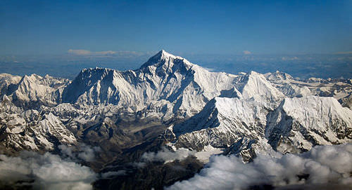
Mount Everest is the world’s highest peak at 29,035 feet.
The Himalayan Mountains dominate the physical landscape in the northern region of South Asia. Mount Everest is the tallest peak in the world at 29,035 feet. Three key rivers cross South Asia, all originating from the Himalayas. The Indus River, which has been a center of human civilization for thousands of years, starts in Tibet and flows through the center of Pakistan. The Ganges River flows through northern India, creating a core region of the country. The Brahmaputra River flows through Tibet and then enters India from the east, where it meets up with the Ganges in Bangladesh to flow into the Bay of Bengal.
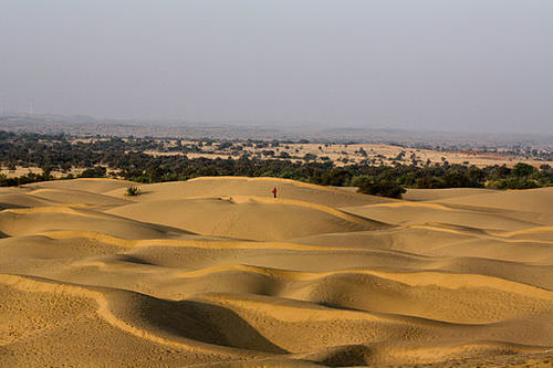
While the northern part of this region includes some of the highest elevations in the world, the Maldives in the south has some of the lowest elevations, some barely above sea level. The coastal regions in southern Bangladesh also have low elevations. When the seasonal reversal of winds called the monsoon arrives every year, there is heavy flooding and its effect on the infrastructure of the region is disastrous. The extensive Thar Desert in western India and parts of Pakistan, on the other hand, does not receive monsoon rains. In fact, much of southwest Pakistan—a region called Baluchistan—is dry, with desert conditions.
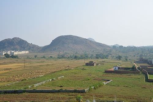
This region is home to Jaipur, Jodhpur and many culturally important cities.
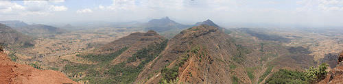
The mountains on the border between Pakistan and Afghanistan extend through Kashmir and then meet up with the high ranges of the Himalayas. The Himalayas create a natural barrier between India and China, with the kingdoms of Nepal and Bhutan acting as buffer states with Tibet. Farther south along the east and west coasts of India are shorter mountain ranges called ghats.
The Western Ghats reach as high as 8,000 feet, but average around 3,000 feet. These ghats are home to an extensive range of biodiversity. The Eastern Ghats are not as high as the Western Ghats but have similar physical qualities. The ghats provide a habitat for a wide range of animals and are also home to large coffee and tea estates. The Deccan Plateau lies between the Eastern and Western Ghats. The Central Indian Plateau and the Chota-Nagpur Plateau are located in the central parts of India, north of the two Ghat ranges. The monsoon rains ensure that an average of about 52 inches of rain per year falls on the Chota-Nagpur Plateau, which has a tiger reserve and is also a refuge for Asian elephants.
The Chota Nagpur Plateau is a plateau in eastern India.
The Monsoon
A monsoon is a seasonal reversal of winds that is associated with heavy rains. The summer monsoon rains—usually falling between June and September—feed the rivers and streams of South Asia and provide the water needed for agricultural production. In the summer, the continent heats up, with the Thar Desert fueling the system. The rising hot air creates a vacuum that pulls in warm moist air from the Bay of Bengal and the Indian Ocean. This action shifts moisture-laden clouds over the land, where the water is precipitated out in the form of rain.
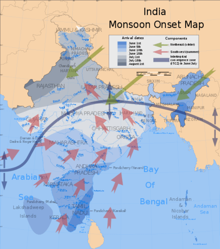
This map shows the average onset (monsoon arrival) dates and wind directions prevalent during India's southwest summer monsoon.
The monsoon rains bring moisture to South Asia right up to the Himalayas. As moisture-laden clouds rise in elevation in the mountains, the water vapor condenses in the form of rain or snow and feeds the streams and basins that flow into the major rivers, such as the Brahmaputra, Ganges, and Indus. The Western Ghats creates a similar system in the south along the west coast of India.
Western Ghats, Maharashtra, India, in May during the dry season.
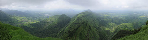
Western Ghats, Maharashtra, India, in August, during Monsoon season.
Parts of Bangladesh and eastern India receive as much as six feet of rain during the monsoon season, and some areas experience severe flooding. The worst-hit places are along the coast of the Bay of Bengal, such as in Bangladesh. There is less danger of flooding in western India and Pakistan because by the time the rain clouds have moved across India they have lost their moisture.
Desert conditions are evident in the west, near the Pakistan border in the great Thar Desert. On average, fewer than ten inches of rainfall per year in this massive desert. On the northern rim of the region, the height of the Himalayas restricts the warm moist monsoon air from moving across the mountain range. The Himalayas act as a precipitation barrier and create a strong rain shadow effect for Tibet and Western China. The monsoon is responsible for much of the rainfall in South Asia.
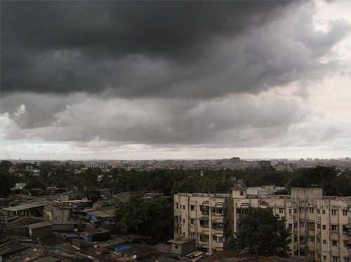
A "monsoon burst" over Mumbai.
By October, the system has run its course and the monsoon season is generally over. In the winter, the cold, dry air above the Asian continent blows to the south, and the winter monsoon is characterized by cool, dry winds coming from the north. South Asia experiences a dry season during the winter months. Small sections of South Asia, such as Sri Lanka and southeastern India, experience a rainy winter monsoon as well as a rainy summer monsoon. In their case, the winter monsoon winds that come down from the north have a chance to pick up moisture from the Bay of Bengal before depositing it on their shores.
Early Civilizations
The Indian subcontinent has a long history of human occupation and is an area where cities independently developed and civilization emerged. The earliest civilization on the subcontinent was the Indus Valley Civilization, in existence from about 3300 B.C.E. to 1500 B.C.E. This Bronze Age civilization started as a series of small villages that became linked in a wider regional network.
.png?revision=1)
The Indus Valley Civilization, or Harappan Civilization, was a Bronze Age civilization (3300–1300 B.C.E.; mature period 2600–1900 B.C.E.) mainly in the northwestern regions of South Asia, extending from what today is northeast Afghanistan to Pakistan and northwest India.
Urban centers developed into various religious and trade networks that spanned as far as Central Asia, Southwest Asia, and perhaps Egypt. The civilization is known for its planned structures. The cities and villages of the urban phases were planned with major streets going north/south and east/west. It had a system of drains that channeled waste water outside the city. The artifacts of pottery and metallurgy all had a similar style that was spread over a vast land area, a fact that aided in the recognition of the expanse of the culture.
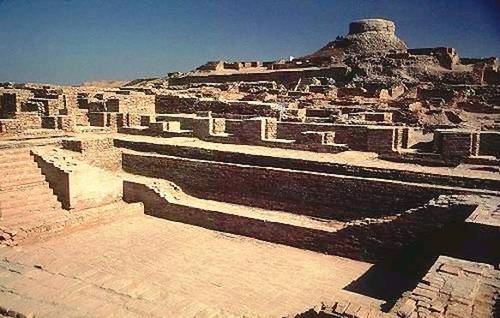
Excavated ruins of Mohenjo-Daro, Sindh province, Pakistan, showing the Great Bath in the foreground.
Invasions by outsiders have the potential effect of bringing with them an influx of new ideas, concepts, and technology. Likewise, the Indus Valley Civilization had an impact on the region that it encompassed. Little is known of the historical events of earlier times. Some of the evidence we rely on today to discern historical events is gleaned from language, religion, and ethnicity.
Significant to South Asia is the presence of Indo-European languages. It is presumed that these languages were brought to the region by immigrants from the west, where these languages were dominant. Aryans from Persia and other cultures might have diffused languages such as Hindi to South Asia, which later may have led to Hindi, for example, becoming the lingua franca of the region.
The northern plains of South Asia, which extend through the Ganges River valley over to the Indus River valley of present-day Pakistan, were fertile grounds for a number of empires that controlled the region throughout history. After the decline of the Indus Valley Civilization, various phases of Iron Age traditions emerged. Most of this Iron Age culture is defined by the presence of iron metallurgy and distinctive characteristics of ceramics.
The Mauryan Empire existed between 322 and 185 B.C.E. and was one of the most extensive and powerful political and military empires in ancient India. This empire was founded by Chandragupta Maurya in 322 B.C.E., who began to extend his regime westward, easily conquering areas that had been disrupted by the expansion of Alexander the Great’s armies. The Mauryan Empire was prosperous and greatly expanded the region’s trade, agriculture, and economic activities.
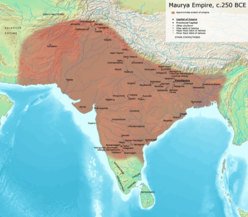
The Maurya Empire was a geographically extensive Iron Age historical power founded by Chandragupta Maurya which dominated ancient India between 322 B.C.E. and 187 B.C.E.
This empire created a single and efficient system of finance, administration, and security. One of the greatest emperors in the Mauryan dynasty was Ashoka the Great, who ruled over a long period of peace and prosperity. Ashoka embraced Buddhism and focused on peace for much of his rule. He created hospitals and schools and renovated major road systems throughout the empire. His advancement of Buddhist ideals is credited with being the reason why most of the population on the island of Sri Lanka is Buddhist to this day.
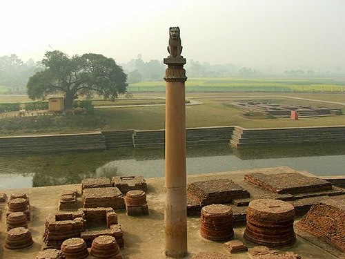
Ashoka the Great, was an Indian emperor of the Maurya Dynasty, who ruled almost all of the Indian subcontinent from c. 268 to 232 B.C.E.
Islam became a powerful force in South Asia upon its diffusion to the subcontinent. Muslim dynasties or kingdoms that ruled India between 1206 and 1526 are referred to as the Delhi Sultanate. The Delhi Sultanate ended in 1526 when it was absorbed into the expanding Mughal Empire. The Islamic Mughal Empire ruled over much of northern and central India from the 1500s to about the middle of the 19th century.
After 1725, the Mughal Empire began to decline because of many factors, one of those factors being European colonialism. The Mughal Empire had been religiously tolerant but Muslim oriented. The classic period of this empire began in 1556 and ended in 1707. Many of the monuments we associate with India, including the Taj Mahal, the Red Fort in Lahore, and the Agra Fort, were built during the classical period.
The largest manufacturing industry in the Mughal Empire was textile manufacturing.
Colonialism in South Asia
The force of colonialism was felt around the world, including in South Asia. South Asia provides an excellent example of colonialism’s role in establishing most of the current political borders in the world. From the 16th century onward, ships from colonial Europe began to arrive in South Asia to conduct trade. The British East India Company was chartered in 1600 to trade in Asia and India. They traded in spices, silk, cotton, and other goods. Later, to take advantage of conflicts and bitter rivalries between kingdoms, European powers began to establish colonies. Britain controlled South Asia from 1857 to 1947.
Goa is the smallest state in modern-day India. In the 16th century, it was first encountered by Portuguese traders, who annexed it shortly after arriving. Goa was a colony of Portugal for the next 450 years. By the mid-1800s, most of the population of the tiny area had been forcibly converted to Christianity. Many of the Hindu traditions, however, survived in the region.
Hindu holidays are celebrated amongst the expatriate community in India. Christian holidays are also celebrated, especially Christmas and Easter. The cathedrals and secular architecture in many of the historic buildings of Goa are European in style, reflecting its Portuguese origins. This architecture is locally termed “Indo-Portuguese.” Goa was one of the longest-held colonial possessions in the world. It was finally annexed to India in 1961.
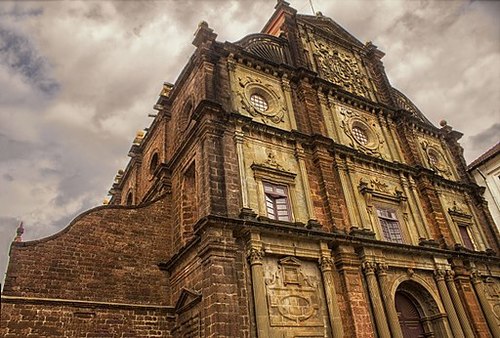
The Basilica of Bom Jesus is located in Goa, India, and is a UNESCO World Heritage Site.
The British no longer controlled South Asia after 1947. Local resistance and the devastating effects of World War II meant the British Empire could not be controlled as it once was. Great Britain pulled away from empire building to focus on its own redevelopment. Upon the British withdrawal from India, Britain realized the immense cultural differences between the Muslims and Hindus and created political boundaries based on those differences.
West Pakistan was carved out of western India, and East Pakistan was carved from eastern India. However, the new borders separating Hindu and Muslim majorities ran through population groups, and some of the population now found itself to be on the wrong side of the border. The West Pakistan-India partition grew into a civil war, as Hindus and Muslims struggled to migrate to their country of choice.
More than one million people died in the civil war, a war that is still referred to in today’s political dialogue between Pakistan and India. The Sikhs, who are indigenous to the Punjab region in the middle, also suffered greatly. Some people decided not to migrate, which explains why India has the largest Muslim population of any non-Muslim state.
Another civil war erupted in 1973 between West Pakistan and East Pakistan. When the states were first created in 1947, they operated under the same government despite having no common border and being over 900 miles apart and populated by people with no ethnic similarities. The civil war lasted about three months and resulted in the creation of the sovereign countries of Pakistan and Bangladesh. The name Bangladesh is based on the Bengali ethnicity of most of the people who live there. Both Pakistan and Bangladesh are among the top ten most populous countries in the world.
Language is probably one of the more pervasive ways that Europeans impacted South Asia. In modern-day India and Pakistan, English is the language of choice in secondary education. It is often the language used by the government and military. Unlike many other Asian countries, much of the signage and advertising in Pakistan and India is in English, even in rural areas. Educated people switch back and forth, using English words or entire English sentences during conversation in their native tongue. Some scholars have termed this Hinglish or Urglish as the base languages of northern India and Pakistan are Hindi and Urdu, respectively.
The British game of cricket is an important cultural and national sport in South Asia. The constant conflict between the nations of India and Pakistan is reflected in the intense rivalry between their national cricket teams. The Cricket World Cup is held every four years and is awarded by the International Cricket Council. South Asian countries have won the Cricket World Cup three times: India (1983), Pakistan (1992), and Sri Lanka (1996).
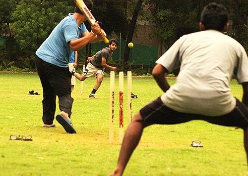
Cricket is the most popular sport in India.
Population in South Asia
South Asia is one of the most populous realms in the world. Large populations are a product of large family sizes and a high fertility rate. The rural population of South Asia has traditionally had large families, and religious traditions generally support this. However, the least densely populated country in South Asia is the Kingdom of Bhutan. Bhutan has a population density of approximately 50 people per square mile. Bhutan is mountainous with little arable land. More than one-third of the people in Bhutan live in an urban setting. Population overgrowth for the realm is a serious concern. An increase in population requires additional natural resources, energy, and food production, all of which are in short supply in many areas.
South Asia’s growing population has placed exceedingly high demands on agricultural production. The amount of area available for food production divided by the population may be a more helpful indicator of population distribution than total population density. For example, large portions of Pakistan are deserts and mountains that do not provide arable land for food production.
India has the Thar Desert and the northern mountains. Nepal has the Himalayas. The small country of the Maldives, with its many islands, has almost no arable land. The number of people per square mile of arable land, which is called the physiologic density, can be an important indicator of a country’s status. Total population densities are high in South Asia, but the physiologic densities are even more surprising.
In Bangladesh, for example, more than 5,000 people depend on every square mile of arable land. In Sri Lanka, the physiologic density reaches to more than 6,000 people per square mile, and in Pakistan, it is more than 2,400. The data are averages, which indicate that the population density in the fertile river valleys and the agricultural lowlands might be even higher. Urban areas of South Asia are expanding rapidly.
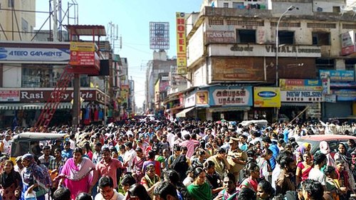
Thyagaraya Nagar is a neighborhood in the city of Chennai, India. It is a popular shopping district.
The population of South Asia is relatively young. In Pakistan, about 35 percent of the population is under the age of 15, while about 30 percent of India’s almost 1.3 billion people are under the age of 15. Many of these young people live in rural areas, as most of the people of South Asia work in agriculture and live a subsistence lifestyle. As the population increases, the cities reflect the growth in the urban population and the large influx of migrants arriving from rural areas.
Rural-to-urban shift is extremely high in South Asia and will continue to fuel the expansion of the urban centers into some of the largest cities on the planet. The rural-to-urban shift that is occurring in South Asia also coincides with an increase in the region’s interaction with the global economy.
The South Asian countries are transitioning through the five stages of the index of economic development. The more rural agricultural regions are in the lower stages of the index. The realm experienced rapid population growth during the latter half of the 20th century. As death rates declined and family size remained high, the population swiftly increased. India, for example, grew from fewer than 400 million in 1950 to more than one billion at the turn of the century.
The more urbanized areas are transitioning into stage 3 of the index and experiencing a significant rural-to-urban shift. Large cities such as Mumbai have sectors that are in the latter stages of the index because of their urbanized workforce and higher incomes. Family size is decreasing in the more urbanized areas and in the realm as a whole. Demographers predict that eventually the population will stabilize.
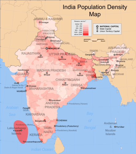
India is the second-most populated country in the world with nearly a fifth of the world's population. This map reflects the 2001 census.
At the current rates of population growth, the population of South Asia will double in about 50 years. Without continued attention to how the societies address family planning and birth control, South Asia will likely face serious resource shortages in the future.
- All of the South Asian countries border India by either a physical or a marine boundary. The Himalayas form a natural boundary between South Asia and East Asia (China). The realm is surrounded by deserts, the Indian Ocean, and the high Himalayan ranges.
- The summer monsoon arrives in South Asia in late May or early June and subsides by early October. The rains that accompany the monsoon account for most of the rainfall for South Asia. Water is a primary resource, and the larger river systems are home to large populations.
- The Indus River Valley was a location of early human civilization. The large empires of the realm gave way to European colonialism. The British dominated the realm for 90 years from 1857 to 1947 and established the main boundaries of the realm.
- Population growth is a major concern for South Asia. The already enormous populations of South Asia continue to increase, challenging the economic systems and depleting natural resources at an unsustainable rate.
Vocabulary Terms
|
A Bay that the Ganges River flows into, North of the Indian Ocean, On the eastern side of India, South of Tibet, West of China |
|
|
River that begins in Tibet, flows through northeast India and Bangladesh, joining with the Ganges to empty into the Bay of Bengal |
|
|
A high area of land at the center of the Indian subcontinent., it lies between the Adrian Sea and the Bay of Bengal and it is made of lava, which produces a rich black soil; it's bordered on the west and east by the Eastern Ghats and the Western Ghats |
|
|
Eastern Ghats |
eroded coastal mountains east of the Deccan Plateau in Southern India |
|
A river of South Asia that flows southeast from the Himalayas to the Bay of Bengal., India's most important river, flows across northern India into Bangladesh, Hindus sacred river, they believe it is the "liquid form of God" |
|
|
A range of mountains with the highest peaks in the world including Mt. Everest. The Himalayas stretch from Pakistan to Bhutan |
|
|
Hindu Kush Mountains |
large mountain range located in northern Pakistan and that provide a barrier between Pakistan and Afghanistan. The Khyber Pass is used to travel between the two countries |
|
A river in South Asia that flows from the Himalayas to the Arabian Sea, the earliest Indian civilization began in the valley of this river |
|
|
a shallow body of water in the center of an atoll |
|
|
monsoon |
regional winds that predictably change direction with the passing of the seasons. These winds blow from land to sea in the winter, and from sea to land in the summer. In summer they are often accompanied by precipitation. |
|
Highest peak in the world, located in the Himalayas |
|
|
A large landmass that is part of a continent |
|
|
A chain of eroded mountains in India that forms a triangle of rugged hills with the Eastern Ghats. It prevents yearly rainy winds from reaching the Deccan Plateau |
Applying Knowledge
Discussion and Study Questions
- Why are the Himalayan Mountains continuing to increase in elevation? Which of the countries of South Asia border the Himalayas?
- What are the three major rivers of South Asia? Where do they start and into what bodies of water do they flow? Why have these river basins been such an important part of the early civilizations of the realm and why are they core population areas today?
- Why does the monsoon usually arrive in late May or early June? What is the main precipitation pattern that accompanies the monsoon? Why is the monsoon a major source of support for South Asia’s large population?
- What changes did British colonialism bring to South Asia? When did the British control South Asia? Why do you think the British lost control when they did?
- Why is the high population growth rate a serious concern for South Asian countries? What can these countries do to address the high population growth rate?
- How can Pakistan have a higher fertility rate than Bangladesh but still have the same growth rate and doubling time?
- Why would the country of the Maldives be concerned about climate change?
- How would you assess the status of each country with regard to the index of economic development?
- What are the three dominant religions of the realm? How did religion play a role in establishing the realms’ borders? What happened to East Pakistan?
Real-World Geography Exercise
- Using Google Maps, complete the following activities:
- Locate each place on the bulleted list below.
- Find the nearest city with an international airport in proximity to each location on the bulleted list below.
- Calculate the distance and travel time by plane to each city from the Charlotte-Douglas International Airport in Charlotte, North Carolina.
- Using NASA Latitude and Longitude Finder, determine the latitude and longitude for each location on the bulleted list below.
- Be prepared to share and discuss your answers.
- Arabian Sea
- Baluchistan
- Bay of Bengal
- Brahmaputra River
- Central Indian Plateau
- Chota-Nagpur Plateau
- Deccan Plateau
- Eastern Ghats
- Ganges River
- Himalayas
- Indian Ocean
- Indus River
- Kashmir
- Mt. Everest
- Punjab
- Thar Desert
- Western Ghats
Current Events
India is Changing Some Cities Names and Muslims Fear Loss of Their Heritage
US Cuts off India Preferential Trade Status
Geography Videos for Enrichment
Helpful Websites for the Study of Geography
Canadian Encyclopedia is an encyclopedia funded by the Canadian government covering all branches of knowledge. Their scholarly collection includes interactive materials.
CIA World Factbook provides information on the people, history, government, economy, energy, geography, communications, transportation, military, and transnational issues for the world's entities.
Congress.gov is a US government website where you can find federal legislation, past and present, as well as information about the US legal system.
Drug Enforcement Administration (DEA) is a government agency website that provides current news, resources, topics of interest, information about drugs, careers in the DEA, and a tip hotline.
Library of Congress is the largest library in the world and provides manuscripts, files, information, pictures, and videos.
NASA Earth Observatory (NEO) is a US government agency website that allows users to search for and retrieve satellite images of Earth.
National Archives is a US government website that provides historical documents, photos, records, publications, and educator resources.
National Oceanic and Atmospheric Association (NOAA) is a US government agency website that provides weather-related information and ocean research.
National Map is a website by the United States Geological Survey and other federal, state, and local agencies that delivers topographic information for the United States.
NationMaster is a massive central data source and a handy way to graphically compare nations.
Real-Time World Air Quality Index is a website that measures most locations in the world for air pollution in real time.
StateMaster is a unique statistical database, which allows you to research and compare a multitude of different data on US states.
United Nations (UN) is an international organization founded in 1945 and made up of 193 member states. The UN maintains international peace and security, protects human rights, delivers humanitarian aid, promotes sustainable development, and upholds international law.
United States Census Bureau is a US government agency that provides a population clock, data, surveys, statistics, a library with information and infographics, news about the economy, and much more.
United States Geological Survey (USGS) is a US government agency website that provides scientific information about the natural hazards that threaten lives, the natural resources we rely on, the health of our ecosystems and environment, and the impacts of climate and land-use change.
Whitehouse.gov is a US government website that provides the latest presidential news, information about the budget, policy, defense, and many more topics.
World Health Organization (WHO) is under the United Nations and provides leadership on matters critical to health, shapes the research agenda on health, and monitors the health situation and assessing health trends around the world. Their website provides information on the state of health around the world, outbreaks, current health news, and more.
World Trade Organization (WTO) is an intergovernmental organization that regulates international trade. The website provides information on the history of the multilateral trading system, featured videos, news and events, trade topics, and more.
WG.4B Describe different landforms and the physical processes that cause their development.
WG.5A Analyze how the character of a place is related to its political, economic, social, and cultural elements.
WG.6A Locate and describe human and physical features that influence the size and distribution of settlements.
WG.6B Explain the processes that have caused changes in settlement patterns, including urbanization, transportation, access to and availability of resources, and economic activities.
WB.12A Analyze how the creation, distribution, and management of key natural resources affects the location and patterns of movement of products, money, and people.
WG.13A Interpret maps to explain the division of land, including man-made and natural borders, into separate political units such as cities, states, or countries.
WG.14A Analyze current events to infer the physical and human processes that lead to the formation of boundaries and other political divisions.
WG.15A Identify and give examples of different points of view that influence the development of public policies and decision-making processes on local, state, national, and international levels.
WG.15B Explain how citizenship practices, public policies, and decision making may be influenced by cultural beliefs, including nationalism and patriotism.
WG.16C Explain ways various groups of people perceive the characteristics of their own and other cultures, places, and regions differently.
WG.17A Describe and compare patterns of culture such as language, religion, land use, education, and customs that make specific regions of the world distinctive.
WG.22A Design and draw appropriate graphics such as maps, diagrams, tables, and graphs to communicate geographic features, distributions, and relationships.
WG.22C Use geographic terminology correctly.
WG.22D Use standard grammar, spelling, sentence structure, and punctuation.
TEKS and ELPS for Regional World Geography Unit 08--Africa from TEKS Resource System.