
2.2: Globalization and Development (5 Days)
- Page ID
- 1946
\( \newcommand{\vecs}[1]{\overset { \scriptstyle \rightharpoonup} {\mathbf{#1}} } \)
\( \newcommand{\vecd}[1]{\overset{-\!-\!\rightharpoonup}{\vphantom{a}\smash {#1}}} \)
\( \newcommand{\dsum}{\displaystyle\sum\limits} \)
\( \newcommand{\dint}{\displaystyle\int\limits} \)
\( \newcommand{\dlim}{\displaystyle\lim\limits} \)
\( \newcommand{\id}{\mathrm{id}}\) \( \newcommand{\Span}{\mathrm{span}}\)
( \newcommand{\kernel}{\mathrm{null}\,}\) \( \newcommand{\range}{\mathrm{range}\,}\)
\( \newcommand{\RealPart}{\mathrm{Re}}\) \( \newcommand{\ImaginaryPart}{\mathrm{Im}}\)
\( \newcommand{\Argument}{\mathrm{Arg}}\) \( \newcommand{\norm}[1]{\| #1 \|}\)
\( \newcommand{\inner}[2]{\langle #1, #2 \rangle}\)
\( \newcommand{\Span}{\mathrm{span}}\)
\( \newcommand{\id}{\mathrm{id}}\)
\( \newcommand{\Span}{\mathrm{span}}\)
\( \newcommand{\kernel}{\mathrm{null}\,}\)
\( \newcommand{\range}{\mathrm{range}\,}\)
\( \newcommand{\RealPart}{\mathrm{Re}}\)
\( \newcommand{\ImaginaryPart}{\mathrm{Im}}\)
\( \newcommand{\Argument}{\mathrm{Arg}}\)
\( \newcommand{\norm}[1]{\| #1 \|}\)
\( \newcommand{\inner}[2]{\langle #1, #2 \rangle}\)
\( \newcommand{\Span}{\mathrm{span}}\) \( \newcommand{\AA}{\unicode[.8,0]{x212B}}\)
\( \newcommand{\vectorA}[1]{\vec{#1}} % arrow\)
\( \newcommand{\vectorAt}[1]{\vec{\text{#1}}} % arrow\)
\( \newcommand{\vectorB}[1]{\overset { \scriptstyle \rightharpoonup} {\mathbf{#1}} } \)
\( \newcommand{\vectorC}[1]{\textbf{#1}} \)
\( \newcommand{\vectorD}[1]{\overrightarrow{#1}} \)
\( \newcommand{\vectorDt}[1]{\overrightarrow{\text{#1}}} \)
\( \newcommand{\vectE}[1]{\overset{-\!-\!\rightharpoonup}{\vphantom{a}\smash{\mathbf {#1}}}} \)
\( \newcommand{\vecs}[1]{\overset { \scriptstyle \rightharpoonup} {\mathbf{#1}} } \)
\(\newcommand{\longvect}{\overrightarrow}\)
\( \newcommand{\vecd}[1]{\overset{-\!-\!\rightharpoonup}{\vphantom{a}\smash {#1}}} \)
\(\newcommand{\avec}{\mathbf a}\) \(\newcommand{\bvec}{\mathbf b}\) \(\newcommand{\cvec}{\mathbf c}\) \(\newcommand{\dvec}{\mathbf d}\) \(\newcommand{\dtil}{\widetilde{\mathbf d}}\) \(\newcommand{\evec}{\mathbf e}\) \(\newcommand{\fvec}{\mathbf f}\) \(\newcommand{\nvec}{\mathbf n}\) \(\newcommand{\pvec}{\mathbf p}\) \(\newcommand{\qvec}{\mathbf q}\) \(\newcommand{\svec}{\mathbf s}\) \(\newcommand{\tvec}{\mathbf t}\) \(\newcommand{\uvec}{\mathbf u}\) \(\newcommand{\vvec}{\mathbf v}\) \(\newcommand{\wvec}{\mathbf w}\) \(\newcommand{\xvec}{\mathbf x}\) \(\newcommand{\yvec}{\mathbf y}\) \(\newcommand{\zvec}{\mathbf z}\) \(\newcommand{\rvec}{\mathbf r}\) \(\newcommand{\mvec}{\mathbf m}\) \(\newcommand{\zerovec}{\mathbf 0}\) \(\newcommand{\onevec}{\mathbf 1}\) \(\newcommand{\real}{\mathbb R}\) \(\newcommand{\twovec}[2]{\left[\begin{array}{r}#1 \\ #2 \end{array}\right]}\) \(\newcommand{\ctwovec}[2]{\left[\begin{array}{c}#1 \\ #2 \end{array}\right]}\) \(\newcommand{\threevec}[3]{\left[\begin{array}{r}#1 \\ #2 \\ #3 \end{array}\right]}\) \(\newcommand{\cthreevec}[3]{\left[\begin{array}{c}#1 \\ #2 \\ #3 \end{array}\right]}\) \(\newcommand{\fourvec}[4]{\left[\begin{array}{r}#1 \\ #2 \\ #3 \\ #4 \end{array}\right]}\) \(\newcommand{\cfourvec}[4]{\left[\begin{array}{c}#1 \\ #2 \\ #3 \\ #4 \end{array}\right]}\) \(\newcommand{\fivevec}[5]{\left[\begin{array}{r}#1 \\ #2 \\ #3 \\ #4 \\ #5 \\ \end{array}\right]}\) \(\newcommand{\cfivevec}[5]{\left[\begin{array}{c}#1 \\ #2 \\ #3 \\ #4 \\ #5 \\ \end{array}\right]}\) \(\newcommand{\mattwo}[4]{\left[\begin{array}{rr}#1 \amp #2 \\ #3 \amp #4 \\ \end{array}\right]}\) \(\newcommand{\laspan}[1]{\text{Span}\{#1\}}\) \(\newcommand{\bcal}{\cal B}\) \(\newcommand{\ccal}{\cal C}\) \(\newcommand{\scal}{\cal S}\) \(\newcommand{\wcal}{\cal W}\) \(\newcommand{\ecal}{\cal E}\) \(\newcommand{\coords}[2]{\left\{#1\right\}_{#2}}\) \(\newcommand{\gray}[1]{\color{gray}{#1}}\) \(\newcommand{\lgray}[1]{\color{lightgray}{#1}}\) \(\newcommand{\rank}{\operatorname{rank}}\) \(\newcommand{\row}{\text{Row}}\) \(\newcommand{\col}{\text{Col}}\) \(\renewcommand{\row}{\text{Row}}\) \(\newcommand{\nul}{\text{Nul}}\) \(\newcommand{\var}{\text{Var}}\) \(\newcommand{\corr}{\text{corr}}\) \(\newcommand{\len}[1]{\left|#1\right|}\) \(\newcommand{\bbar}{\overline{\bvec}}\) \(\newcommand{\bhat}{\widehat{\bvec}}\) \(\newcommand{\bperp}{\bvec^\perp}\) \(\newcommand{\xhat}{\widehat{\xvec}}\) \(\newcommand{\vhat}{\widehat{\vvec}}\) \(\newcommand{\uhat}{\widehat{\uvec}}\) \(\newcommand{\what}{\widehat{\wvec}}\) \(\newcommand{\Sighat}{\widehat{\Sigma}}\) \(\newcommand{\lt}{<}\) \(\newcommand{\gt}{>}\) \(\newcommand{\amp}{&}\) \(\definecolor{fillinmathshade}{gray}{0.9}\)- Explain how the concepts of opportunity and advantage create a stronger rural-to-urban shift and fuel migration in various regions of the world.
- Describe the dynamics of the core-periphery spatial relationship and determine whether a country is a part of the core or periphery by its respective attributes.
- Explain how countries gain national income and which activities are renewable or have value-added profits. Understand the vital roles that labor and resources play in the economic situation for each country.
- Describe the patterns illustrated in the index of economic development—especially in terms of how it illustrates a country’s development status in regard to family size and economic indicators.
- Define the concepts of rural-to-urban shift, core-periphery spatial relationships, opportunity and advantage, and "haves" and "have-nots".
TEKS Regional Unit 02 Human Geographic Systems Chapter 2.2
WG.9B Describe different types of regions, including formal, functional, and perceptual regions
WG.10A Describe the forces that determine the distribution of goods and services in free enterprise, socialist, and communist economic systems.
WG.10B Classify where specific countries fall along the economic spectrum between free enterprise and communism.
WG.10C Compare the ways people satisfy their basic needs through the production of goods and services such as subsistence agriculture versus commercial agriculture or cottage industries versus commercial industries.
WG.10B Compare global trade patterns over time and examine the implications of globalization, including outsourcing and free trade zones.
WG. 10B Compare global trade patterns over time and examine the implications of globalization, including outsourcing and free trade zones.
WG.11A Understand the connections between levels of development and economic activities (primary, secondary, tertiary, and quaternary).
WG.11B Identify the factors affecting the location of different types of economic activities, including subsistence and commercial agriculture, manufacturing, and service industries.
WG.16B Describe elements of culture, including language, religion, beliefs and customs, institutions and technologies.
WG.22A Design and draw appropriate graphics such as maps, diagrams, tables, and graphs to communicate geographic features, distributions, and relationships, features, distributions, and relationships
Globalization and Development
Globalization
US President George H. W. Bush gave a speech during his presidency (1988–92) indicating the real possibility of a New World Order. This speech, given during the Persian Gulf War when Iraq occupied Kuwait, was surprising to many people. What did the president mean by New World Order? This term has been used before to refer to times in history when great changes were taking place and a collective effort was needed to address problems. The goal in geography is to understand globalization and to make sense of what is happening. The better we understand the world and human dynamics, the better prepared we will be for our future. Geography provides a means to examine these changes.
Globalization is a process with a long history. People have been exploring, migrating, and trading with each other throughout human history. These activities have created networks connecting the different parts of the planet and producing dependent economic relationships. In modern times, globalization is shown when corporations, such as Walmart, McDonald’s, or Ford, trade across international borders and use labor and resources from different countries to sell products and services in the global marketplace.
European colonialism was the first wave of globalization that shaped the world in many ways. Propelled by the Industrial Revolution, this conquest spread technology, food products, and ideas across the globe. The European colonial empires of Europe were mainly Britain, Spain, France, Portugal, and the Netherlands. Once the United States became independent of these European colonial powers, it also began to extend its power and influence around the world.
In many countries, people have protested the building of global corporations. Such protests cause concern about globalization and the growing expansion of a dominant global economy into local communities. These iconic corporations represent interests that are concerned with high profits. Because of this, what matters to these businesses is how these countries and communities function as markets, sources of labor, or raw materials. The main force that encourages globalization is economic activity based on technological advancements. As the world becomes more global, cultural and societal changes occur as a result.
Political geography examines geography’s influence on political systems and globalization. There is a link between the history of colonialism and the development of capitalism. Eric Wolf, in his book Europe and the People without History, details the expansion of European powers throughout the world to control human and natural resources, expand a country’s world power, and promote Christianity. In the past, the British Empire exported its parliamentary system throughout the world. The parliamentary system continues to be used around the world in former British colonies and the British Commonwealth. Additionally, colonialism helped spread the English language in such places as India and the United States.
The Space Race and the Information Age in the late 20th century caused a second wave of globalization. The space race was a competition between the United States and the Soviet Union to develop space-related technologies. The end of the Cold War, which happened with the collapse of the Soviet Union in 1991, occurred at the same time as advancements in computer technology. These two forces have moved globalization forward at an unprecedented rate of speed. Moreover, these forces have had huge consequences on the environment.
European colonialism and multinational corporations have similarities and differences. Corporations do not own a country or run a government. They are not concerned with who is in power as long as they can operate and make a profit. This neocolonialism (new colonialism or corporate colonialism), like European colonialism, continues to use natural resources, labor, and markets, for profit. Critics claim that neocolonialism is nothing more than a legal method of pillaging and plundering. Supporters claim it is the most efficient use of labor and resources to supply the world with low-priced products.
Opportunity and Advantage
People with access to opportunities and advantages typically have a higher standard of living than people who do not. This can be true for individuals, global corporations, or countries. Opportunities and advantages are determined by various factors such as natural or human resources, arable land for farming, forests for timber, fresh water for fishing, or a location that provides access to world markets. Examples of human resources are a large labor pool or a high percentage of educated professionals. Individuals seek to gain opportunities or advantages by increasing their education, learning new skills that can translate into higher earning power, or migrating to a place with good jobs.
The rural-to-urban shift occurs when people move from rural areas to cities. Individuals moving to a city in search of a better life (i.e., employment) is an example of a migration pattern based on people seeking greater opportunities or advantages. When people migrate from a poorer country to a post-industrial country, they are seeking opportunities or advantages in life. The “have” countries are those with opportunities and advantages. The “have-not” countries are those with fewer opportunities and advantages for their people or for their country’s future. Migration patterns around the world usually shift people from places without resources to places with resources. These migration patterns, which are evident in rural-to-urban shift and periphery-to-core migration, allow individuals to seek greater opportunities or advantages for the future.
Core-Periphery Spatial Relationship
Economic conditions vary across the globe. There are wealthy countries and there are poor countries. Countries that are wealthy versus countries that are poor have generally been determined by the availability of economic opportunities and advantages. The three core areas of wealthy industrialized countries are located in North America, Western Europe, and eastern Asia. The main market centers of these regions are New York City, London, and Tokyo. These three core areas and their rich neighbors make up the centers of economic activity that drive the global economy. Other wealthy countries are found in regions with large amounts of natural resources, such as the Middle East, or strategic locations, such as Singapore. The world’s poorer countries make up the peripheral countries. A few countries share qualities of both and may be called semi-peripheries.
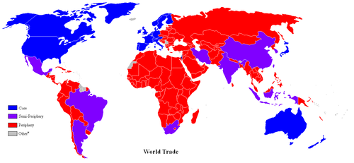
This World Trade map illustrates the countries that are in the core, the semi-periphery, and the periphery.
The periphery countries and the core countries each have unique characteristics. Peripheral locations are providers of raw materials and agricultural products. In the periphery, more people earn their living in occupations related to securing resources like farming, mining, or harvesting forest products. Workers in these jobs tend to make less money and have less chance for promotions. In the periphery, there is a condition known as brain drain, which describes a loss of educated or professional individuals. Young people leave the peripheral areas for the cities to earn an education or to find better employment. Very few of these individuals return.
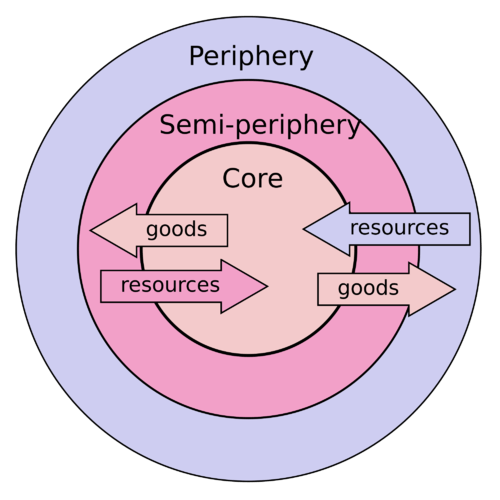
The Core-periphery Model illustrates how power (economic, political, cultural) is distributed.
Brain drain also happens on an international level. Students from periphery countries might go to college in core countries, such as the United States or countries in Europe. Many international college graduates do not return to their poorer countries of origin. Instead, they choose to stay in the core country because of employment opportunities. This is especially true in the medical field. There is little political power in the periphery because centers of political power are usually located in the core areas or at least dominated by the core cities. The core areas pull in people, skills, and wealth from the periphery. Lack of opportunities in the periphery pushes people to relocate to the core.
Power, wealth, and opportunity historically have been centered in the core areas of the world. These locations are urbanized and industrialized and hold immense economic and political power. Moreover, cultural activity thrives in these core areas. Influential people, who live in the core, are the ones who hold political power. Core countries, in general, have the best standards of living. According to the World Economic Forum, the countries with the highest quality of life are New Zealand, Iceland, United Kingdom, Netherlands, Norway, Sweden, Switzerland, Australia, Denmark, Canada, and Finland. The core depends on the periphery for raw materials, food, and cheap labor. On the other hand, the periphery depends on the core of manufactured goods, services, and governmental support.
The core-periphery spatial relationship is multifaceted. On a local level, the city of Morehead in eastern Kentucky is an example. Morehead has a population of about 7,000 people and is the only town in the region with a university, regional hospital, retail services, and serves as a core hub for the surrounding periphery. The hinterland of Morehead has an economy based on agriculture, coal mining, and timber, which is typical of a peripheral region. Morehead has the political, economic, and educational power that serves the people of its local area.
Entire regions of the United States are peripheral areas. The agricultural Midwest, rural Appalachia, and the mountain ranges and basins of the western United States are examples of peripheral areas. The large metropolitan areas of the east and west coasts and the Industrial Belt act as the core areas. Los Angeles and New York City anchor each coast, and cities such as Chicago, St. Louis, Denver, and Indianapolis represent the heartland. All the other large cities in the United States act as core areas for their surrounding peripheral hinterlands. Southern cities such as Atlanta, Memphis, Dallas, or Phoenix act as core centers of commerce for the South in a region known as the Sun Belt.
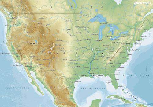
This map illustrates the major core cities in the United States.
On a global scale, we can understand why North America, Western Europe, and eastern Asia represent the three main economic core areas of the world. They all possess the most advanced technology and the greatest economic resources. Core regions control the corporate markets that energize and fuel global activity. Peripheral regions include portions of Africa, Asia, Latin America, and all the other places that primarily make their living from local resources and support the economic core. These peripheral regions may include key port cities.
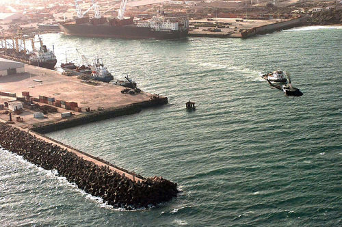
Somalia is a periphery country. The city of Mogadishu in Somalia has an estimated population between 1.5 to 3 million people. It is a key port city.
A semi-periphery would be a transitional area between the core and the periphery, which could include countries such as Russia, India, or Brazil that are not exactly in the core and not really in the periphery but might have qualities of both. World migration patterns follow the core-periphery spatial relationship in that people and wealth usually shift from the peripheral rural regions to the urban core regions. The “have” countries of the world are in the core regions, while the “have-not” countries are most likely in the peripheral regions.
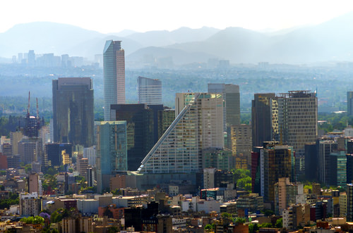
Mexico is considered a semi-periphery country because it is industrializing and is positioned between a core and a periphery country.
National Income Methods
It is easier to understand why people move from rural to urban or from periphery to core when one begins to understand the global economy. Economic conditions are connected to how countries gain national income, opportunities, and advantages. One way of gaining wealth is simply by taking the wealth that belongs to another. This method has been common practice throughout human history when a group of armed individuals attacks another group and takes their possessions or resources. Pillaging and plundering have been a standard way of gaining wealth throughout human history. The global economic community frowns on the taking of resources by force or by war. Nonetheless, it is still happening in places around the world, such as off the coast of Somalia with piracy.
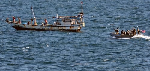
A visit, board, search and seizure team from the guided-missile destroyer USS Truxtun approaches a dhow in the Gulf of Aden.
The main methods countries use to gain national income are based on sustainable national income models and value-added principles. The traditional three areas of agriculture, extraction/mining, and manufacturing are a result of primary and secondary economic activities. Natural resources, agriculture, and manufacturing are targeted as the means to gain national income. Postindustrial activities in the service sector would include tertiary, quaternary, and quinary economic activities, which make up a large part of a nation’s economy but might not hold the same value-added quotient for national income as the traditional three areas.
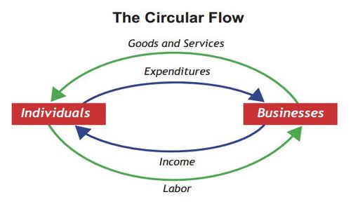
In this circular flow National Income Model, the Bureau of Economic Analysis with the US Department of Commerce illustrates a sustainable way that a country earns money.
Agriculture is the method of growing crops or trees or raising livestock that provides food and some raw materials. This is a renewable method of gaining wealth, as long as conditions are favorable. Profits for agricultural products might be low because of global competition. Countries with minerals, oil, or other natural resources can earn income from the extraction and sale of those items. Saudi Arabia and other countries with abundant petroleum reserves can gain wealth by selling that resource to other countries. Since these resources are not renewable, once the minerals or oil runs out, the country must turn to other activities to gain national income.
Many places around the world are named for what they produce. The Gold Coast of western Africa received its label because of the abundance of gold in the region. The term breadbasket often refers to a region with abundant agricultural surpluses. The Champagne region of France is well known by the beverage made from the grapes grown there. The Banana republics earned their name because the large fruit plantations were the main income source for the large corporations that operated them. Places such as Copper Canyon and Silver City are examples of towns, cities, or regions named after the natural resources found there. The United States had its Manufacturing Belt, referring to the region from Boston to St. Louis, which was the core industrial region that generated wealth through heavy manufacturing for the greater part of 19th and 20th centuries.
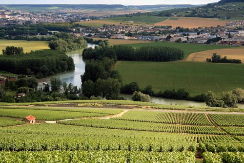
This photo shows a few vineyards in the Champagne wine region of France.
Manufacturing has offered the industrialized world the opportunity for the greatest value-added profits. From the beginning of the Industrial Revolution, profits were made by turning raw materials into products that could be sold in high quantities. The core areas of the world have all made enormous wealth from manufacturing profits. Today, information technology and high-tech manufactured products generate substantial wealth. The Microsoft Corporation manufactures information by placing data in the form of computer programs on inexpensive disks or in digital files that are then sold at a profit to a world computer market. The geographic region of California south of San Francisco was labeled Silicon Valley after this type of information-generating activity.
For a country to gain national wealth, income must be brought in from outside the country or generated from within. Other than the big-three methods of agriculture, extraction/mining, and manufacturing, countries can create wealth through tourism and services. The service sector contributes to a large percentage of employment opportunities in industrialized countries and generates income to national economies.
However, the service sector does not have the high value-added profits traditionally provided by the manufacturing sector. In the gaming industry, for example, casinos do not have a large wealth-generating potential for the country unless they can either attract gamblers from other countries or provide for other wealth-generating services. Gambling shifts wealth from one person to another and provides little national income. A benefit of the gambling industry is that it creates service jobs.
National Debt
Countries with few opportunities to gain wealth to support their governments often borrow money to provide services for their people. The national debt is a major problem for national governments. National income can be consolidated into the hands of a minority of the population at the top of the socioeconomic strata. These social elites have the ability to dominate the politics of their countries or regions.
The elites may hold most of a country’s wealth, while at the same time their government might not always have enough revenue to pay for public services. To pay for public services, the government might need to borrow money, which then increases that country’s national debt. The government could have a high national debt even when the country is home to a large number of wealthy citizens or a growing economy.
Taxes are a standard method for governments to collect revenue. If economic conditions decline, the amount of taxes collected can also decline, which could leave the government in a shortfall. Again, the government might borrow money to continue operating and to provide the same level of services. Political corruption and the mismanagement of funds can also cause a country’s government to lack revenue to pay for the services it needs to provide its citizens.
The national debt, defined as the total amount of money a government owes, is a growing concern across the globe. Many governments have problems paying their national debt or even the interest on their national debt. Governments whose debt has surpassed their ability to pay have often inflated their currency to increase the amount of money in circulation, a practice that can lead to hyperinflation and eventually the collapse of the government’s currency, which could have serious negative effects on the country’s economy. In contrast to the national debt, the term budget deficit refers to the annual cycle of accounting of a government’s excess spending over the amount of revenue it takes in during a given fiscal year.
Development and Demographics
The Industrial Revolution, which prompted the shift in population from rural to urban, also encouraged market economies, which have evolved into modern consumer societies. Various theories and models have been developed over the years to help explain these changes. For example, in 1929, the American demographer Warren Thompson developed the Demographic Transition Model (DTM) to explain population growth based on an interpretation of demographic history. A revised version of Thomson’s model outlines five stages of demographic transition, from traditional rural societies to modern urban societies:
- Stage 1: High birth and death rates; rural pre-industrial society
- Stage 2: Declining death rate; developing country
- Stage 3: Declining birth rate; high urbanization rate
- Stage 4: Low birth and death rates; stabilized population
- Stage 5: Declining population; urban post-industrial society
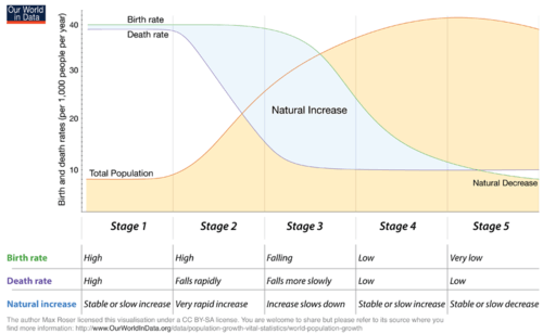
This diagram of the Five Stages of the Demographic Transition Model traces the development from rural, pre-industrial society to urban, post-industrial society.
In the 1960s, economist Walt Rostow outlined a pattern of economic development that has become one model for growth in a global economy. Rostow’s model outlined the five stages of growth in the economic modernization of a country. In this model, a society begins at stage 1 called "traditional society" and moves up the ladder until becoming a stage 5 "age of high mass consumption" society.
- Stage 1: Traditional society
- Stage 2: Preconditions for take-off
- Stage 3: Take-off
- Stage 4: Drive to maturity
- Stage 5: Age of high mass consumption
The Human Development Index (HDI) was developed in 1990 and used by the United Nations Development Programme to measure a standard of human development. Human development refers to the widening opportunities available to individuals for education, health care, income, and employment. The HDI incorporates variables such as standards of living, literacy rate, and life expectancy to indicate a measure of well-being or the quality of life for a specific country. The HDI is an indicator of a country’s economic and technological development.
The basic principles of Rostow’s DTM and the HDI can be illustrated in a general index for understanding development. Two variables of the DTM’s correlating five stages are family size and economic income, which illustrates the population pattern or development potential. All countries of the world are at one of the five stages. The general index addresses how population growth rates relate to rural-to-urban shift, which has traditionally been a result of industrialization. By tracking both family size and economic conditions, a pattern of population growth and economic development can be illustrated and more clearly understood.
The number of children born to a woman in her lifetime is the fertility rate. Fertility rate may (or may not) vary from family size, which is an indication of the number of living children raised by a parent or parents in the same household. A high infant mortality rate may account for a fertility rate that is greater than family size. To simplify the understanding, family size is used in this textbook to illustrate economic dynamics. Though the statistical data may vary slightly between the two terms, this should not present any problem in understanding basic patterns of development.
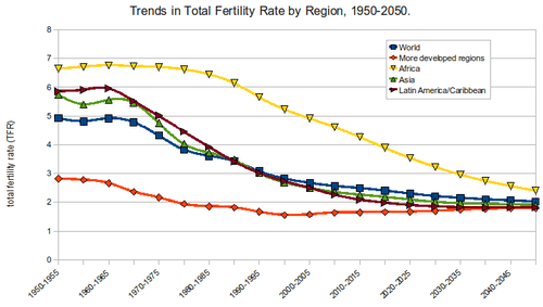
This graphic illustrates the total fertility rate worldwide from 1950 until 2050.
As a general trend, when a country experiences increasing levels of industrial activity and greater urban growth, the outcome is usually a higher standard of living for its people. Additionally, a rural-to-urban shift takes place, driven by the pull of opportunities and advantages in the industrializing and urbanizing areas. Though there are exceptions, a decrease in family size usually coincides with a higher level of urbanization. There are cases in which only core regions within a country transition through the five development stages without the peripheral regions experiencing the coinciding levels of economic benefit. The five stages of the index of economic development assist in illustrating these general patterns.
Stage 1 indicates traditional rural societies, which are usually based on agriculture and not as dependent on the outside world. Stage 1 families are larger, their income levels are low, and their advantages and economic development opportunities are low. Health care, education, and social services are in short supply or nonexistent. High birth and death rates maintain a high fertility rate/family size and a low population-growth status. Populations in stage 1 development have a stationary population pyramid. Although there may be regions of the world that exhibit stage 1 development patterns, few if any entire countries fall into this category as of the year 2000.
Stage 2 countries experience high population growth rates because family size remains high but modern medicine or improved nutrition allows people to live longer, which lowers the death rate. The population is exploding in countries in stage 2. During this stage, young people from rural areas often migrate to the cities looking for employment. Rural stage 2 regions are starting to urbanize and integrate their economic activities with the outside world. Regions in stage 2 often have a surplus of cheap labor. Income levels remain low and family size continues to be large. Countries in this stage often have a rapidly expanding population pyramid.
Societies that have made business connections that provide for the manufacturing of products, industrial activities, or an increased service sector might progress to stage 3, the rural-to-urban shift stage. These regions are experiencing a high rate of rural-to-urban shift in their populations. These regions are often targeted by multinational corporations for their labor supply As people migrate from rural areas to the cities looking for employment, urban populations grow and core or central cities experience high rates of self-constructed housing (slums). Income levels start to increase and family size starts to drop significantly. Stage 3 countries have an expanding population pyramid.
Societies that have urbanized and industrialized and are members of the global marketplace might enter stage 4. Members of an urban workforce assist in building a networked economy. Family size is lower as urban women enter the workforce and have fewer children. Health care, education, and social services become more available, and income levels continue to rise. In stage 4, there is typically a high level of growth in the industrial and service sectors with a great need for infrastructure in the form of transportation, housing, and human services. Countries in stage 4 development have populations that resemble a stationary population pyramid.
As incomes increase and family size decreases, a consumer society emerges, creating stage 5, where high mass consumption can drive the economy. Many countries in stage 5 can eventually experience a negative population growth rate in which the fertility rate (family size) is below replacement levels (statistically around 2.1 children). With a low number of young people entering the workforce, stage 5 regions become an attractive magnet for people looking for opportunities and advantages in the job market. Illegal immigration might become an issue. Europe and the United States are now experiencing this condition. Japan has the same low family size, but because of their island location and strict laws, they have a different set of illegal immigration issues compared with Europe or the United States. Populations in stage 5 development have a contracting population pyramid.
The four basic shapes of population pyramids parallel the various stages of a country’s economic development. Many of the concepts used in this textbook are interrelated. The various methods, models, or theories used in geography are often used by other disciplines as well. In this case, the stages of economic development and the population pyramids illustrate the contrast between rural and urban societies and the changes in family size during the industrialization process.
Geography of Opportunity
Highly industrialized countries in western Europe, eastern Asia, or North America can offer more economic opportunities compared with developing countries. The push-pull factors that push people out of poorer countries and pull them to an industrialized country are strong. Portions of the population of countries in the earlier stages of the index of economic development often migrate to countries in the latter stages of the index looking for work and other opportunities.
This transition has created differences between people who have opportunities and advantages and those who do not. People who do not have opportunities and advantages often want to move to places that do have them so they can work to attain greater economic security for themselves and their families. The haves and have-nots are general categories of economic status and not necessarily cultural values.
Countries in stage 4 or 5 of the index of economic development are often attractive places for those seeking greater economic opportunities or advantages. Populations in these stages generally have fewer children, so the demand for entry-level workers is often higher. Immigrants with fewer skills take entry-level jobs to enter the workforce. An established country with a long history and culture does not always welcome the arrival of new immigrants.
An immigrant labor pool often includes individuals who hold different cultural traditions or customs than those of the mainstream society. Social tensions arise if different ethnic groups are competing for the same cultural spaces and opportunities such as are seen in Europe and the United States. The immigration issue is one that will continue to be debated for as long as we have people leaving their countries for better opportunities and advantages.
Opportunities in Geography
The following information on careers in geography is from the website of the Association of American Geographers (AAG), which is a resource for those interested in pursuing employment in the field of geography. Many occupations require knowledge of and skills in geography. Geographers work in many different areas, such as environmental management, education, disaster response, city and county planning, community development, and more. Geography is an interdisciplinary field that offers diverse career opportunities. Many geographers pursue rewarding careers in business, local, state, or federal government agencies, nonprofit organizations, and schools. Geographers with graduate degrees may become educators in higher education such as community colleges and universities.
Using information from the US Department of Labor, the AAG has compiled data on a broad list of occupations related to geography. Using this online career database, you can explore the diverse career opportunities available to geographers, as well as retrieve data on salaries, projected growth, demand for key skills, and much more to guide your career planning. Go to AAG Guide to Jobs and Careers in Geography to explore what kinds of jobs are available in the field of geology.
- The search for cheap labor and resources drives the need for profits by multinational corporations that fuel the global economy. This activity is creating a second major wave of globalization, often referred to as neocolonialism or corporate colonialism.
- The concepts of opportunity and advantage provide a means to understand the attractiveness or unattractiveness of a place to immigrants or economic activities.
- Opportunities and advantages drive rural-to-urban shift, migration, and movement of corporate activity.
- Core areas are usually urban with high levels of industrial and economic development.
- Peripheral areas are typically suppliers of food and raw materials used in the core.
- Political and economic power is held in the core, while the periphery suffers from lower incomes and brain drain.
- National income methods are based on standard economic practices and value-added principles.
- Agricultural activities are renewable, but extractive activities are not.
- Manufacturing has historically provided the highest value-added profits and has been the main means of the core economic regions of the world to gain income.
Vocabulary Terms
| core country | More economically developed countries--ex. Germany, Japan, Canada |
| developed country | A country which has progressed adequately with regard to economic, mortality and demographic indicators |
| developing country | A country which has not progressed adequately with regard to economic, mortality and demographic indicators |
| fertility rate | The number of children a woman of childbearing years will have in her lifetime |
| gross domestic product | The value of only goods and services produced in a country within a given time |
| gross national income | A measure that reflects the economic state of a country. GNI is the total income generated by a country in 12 months after expenses owing to their countries have been paid |
| human development index | A measure of human development which combines indicators of life expectancy, educational levels, and income |
| infant mortality rate | The number of deaths per 1000 between ages 0-1 |
| mortality rate | The number of deaths per 1000 people in the population |
| peripheral country | A country that is considered less economically developed. Ex. many countries found in Sub-Saharan Africa |
| population pyramid | A graphic device that shows sex and age distribution of a population |
|
rate of natural increase |
Determines if a country's population is increasing or decreasing. Subtract mortality rate from birth rate |
|
semi-peripheral country |
These countries fall between the core and periphery, most of them newly industrialized--ex. Mexico, India, Russia, Brazil |
|
sustainability |
Meeting the needs of the present without compromising the ability of future generations to meet their own needs |
Applying Knowledge
Interactive Notebook Activities
- Explain how the concepts of opportunity and advantage create a stronger rural-to-urban shift and fuel migration in various regions of the world.
- Describe the dynamics of the core-periphery spatial relationship and determine whether a country is a part of the core or periphery by its respective attributes.
- Explain how countries gain national income and which activities are renewable or have value-added profits.
- Illustrate in a chart or diagram the relationship between labor and resources in the economic situation for each country.
- Describe the patterns illustrated in the index of economic development—especially in terms of how it illustrates a country’s development status about family size and economic indicators.
- Define the concepts of rural-to-urban shift, core-periphery spatial relationships, opportunity and advantage, and haves and have-nots.
Discussion and Study Questions
- What prompted the first major wave of rural-to-urban migration in modern history?
- What human economic activities would you find in a core region? What human economic activities would you encounter in the periphery?
- What does opportunity and advantage mean? How do these terms help us understand world geography?
- What are the three main traditional methods through which a country can gain national income? Of the three, which has traditionally provided the highest value-added profits?
- What are the three main economic core areas of the world that have dominated the global economy?
- What are the main elements of business that global corporations seek in terms of a geographic location to make the highest profits?
- What is the main human migration pattern between the core and the periphery?
- What does each stage of the index of economic development represent or illustrate?
- Would minimum wage tend to go up or down for countries moving from stage 4 to stage 5 of the index of economic development?
- How is it that countries with strong or stable economies run up a high national debt?
Real-World Geography Exercise
- Using the Internet, compare the main opportunities and advantages for the place you live with another place either in the same country or in another country with a similar population pyramid profile.
- Research and list the main economic activities for your city or country. Do any of the activities you found compare with what you learned in this textbook?
- Research and describe the main migration pattern for people moving into or out of your current location.
Mapping Exercise
Understanding Globalization: Students will investigate how connections are made across Earth, focusing on advancements in transportation and technology. The activity uses a web-based map.
Videos for Geography Enrichment
Helpful Websites for the Study of Geography
Canadian Encyclopedia is an encyclopedia funded by the Canadian government covering all branches of knowledge. Their scholarly collection includes interactive materials.
CIA World Factbook provides information on the people, history, government, economy, energy, geography, communications, transportation, military, and transnational issues for the world's entities.
Congress.gov is a US government website where you can find federal legislation, past and present, as well as information about the US legal system.
Drug Enforcement Administration (DEA) is a government agency website that provides current news, resources, topics of interest, information about drugs, careers in the DEA, and a tip hotline.
Library of Congress is the largest library in the world and provides manuscripts, files, information, pictures, and videos.
NASA Earth Observatory (NEO) is a US government agency website that allows users to search for and retrieve satellite images of Earth.
National Archives is a US government website that provides historical documents, photos, records, publications, and educator resources.
National Oceanic and Atmospheric Association (NOAA) is a US government agency website that provides weather-related information and ocean research.
National Map is a website by the United States Geological Survey and other federal, state, and local agencies that delivers topographic information for the United States.
NationMaster is a massive central data source and a handy way to graphically compare nations.
Real-Time World Air Quality Index is a website that measures most locations in the world for air pollution in real time.
StateMaster is a unique statistical database, which allows you to research and compare a multitude of different data on US states.
United Nations (UN) is an international organization founded in 1945 and made up of 193 member states. The UN maintains international peace and security, protects human rights, delivers humanitarian aid, promotes sustainable development, and upholds international law.
United States Census Bureau is a US government agency that provides a population clock, data, surveys, statistics, a library with information and infographics, news about the economy, and much more.
United States Geological Survey (USGS) is a US government agency website that provides scientific information about the natural hazards that threaten lives, the natural resources we rely on, the health of our ecosystems and environment, and the impacts of climate and land-use change.
Whitehouse.gov is a US government website that provides the latest presidential news, information about the budget, policy, defense, and many more topics.
World Health Organization (WHO) is under the United Nations and provides leadership on matters critical to health, shapes the research agenda on health, and monitors the health situation and assessing health trends around the world. Their website provides information on the state of health around the world, outbreaks, current health news, and more.
World Trade Organization (WTO) is an intergovernmental organization that regulates international trade. The website provides information on the history of the multilateral trading system, featured videos, news and events, trade topics, and more.
Students will investigate how connections are made across Earth, focusing on advancements in transportation and technology. The activity uses a web-based map.
| Image | Reference | Attributions |
|
[Figure 1] | Credit: By Lou Coban (Based on File:Anglosphere_map.png.) [Public domain], via Wikimedia Commons) Source: By Lou Coban (Based on File:Anglosphere_map.png.) [Public domain] ; via Wikimedia Commons) License: CC BY-NC 3.0 |
|
[Figure 2] | Credit: http://open.lib.umn.edu/worldgeograp...-to-the-world/ Source: http://open.lib.umn.edu/worldgeography/part/chapter-1-introduction-to-the-world/ License: CC BY-NC 3.0 |
|
[Figure 3] | Credit: Source: https://mapswire.com/countries/united-states/ Source: Source: https://mapswire.com/countries/united-states/ License: CC BY-NC 3.0 |
|
[Figure 4] | Credit: By TSGT PERRY HEIMER [Public domain], via Wikimedia Commons Source: By TSGT PERRY HEIMER [Public domain] ; via Wikimedia Commons License: CC BY-NC 3.0 |
|
[Figure 5] | Credit: By Lidia Lopez [CC BY 2.0 (http://creativecommons.org/licenses/by/2.0)], via Wikimedia Commons Source: By Lidia Lopez [CC BY 2.0 (creativecommons.org/licenses/by/2.0)] ; via Wikimedia Commons License: CC BY-NC 3.0 |
|
[Figure 6] | Credit: Source: U.S. Navy photo by Mass Communication Specialist 2nd Class Tony D. Curtis/Released Source: Source: U.S. Navy photo by Mass Communication Specialist 2nd Class Tony D. Curtis/Released License: CC BY-NC 3.0 |
|
[Figure 7] | Credit: Source: By Bureau of Economic Analysis (BEA), U.S. Department of Commerce, October 2014 [Public domain], via Wikimedia Commons Source: Source: By Bureau of Economic Analysis (BEA) ; U.S. Department of Commerce ; October 2014 [Public domain] ; via Wikimedia Commons License: CC BY-NC 3.0 |
|
[Figure 8] | Credit: By Rob & Lisa Meehan (originally posted to Flickr as Champagne Vineyards) [CC BY 2.0 (http://creativecommons.org/licenses/by/2.0)], via Wikimedia Commons Source: By Rob & ; Lisa Meehan (originally posted to Flickr as Champagne Vineyards) [CC BY 2.0 (creativecommons.org/licenses/by/2.0)] ; via Wikimedia Commons License: CC BY-NC 3.0 |
|
[Figure 9] | Credit: By Max Roser [CC BY-SA 4.0 (https://creativecommons.org/licenses/by-sa/4.0)], via Wikimedia Commons Source: By Max Roser [CC BY-SA 4.0 (creativecommons.org/licenses/by-sa/4.0)] ; via Wikimedia Commons License: CC BY-NC 3.0 |
|
[Figure 10] | Credit: By Rcragun [CC BY 3.0 (http://creativecommons.org/licenses/by/3.0)], from Wikimedia Commons Source: By Rcragun [CC BY 3.0 (creativecommons.org/licenses/by/3.0)] ; from Wikimedia Commons License: CC BY-NC 3.0 |