
3.1: Physical Geography of the United States and Canada (2 Days)
- Page ID
- 1956
\( \newcommand{\vecs}[1]{\overset { \scriptstyle \rightharpoonup} {\mathbf{#1}} } \)
\( \newcommand{\vecd}[1]{\overset{-\!-\!\rightharpoonup}{\vphantom{a}\smash {#1}}} \)
\( \newcommand{\dsum}{\displaystyle\sum\limits} \)
\( \newcommand{\dint}{\displaystyle\int\limits} \)
\( \newcommand{\dlim}{\displaystyle\lim\limits} \)
\( \newcommand{\id}{\mathrm{id}}\) \( \newcommand{\Span}{\mathrm{span}}\)
( \newcommand{\kernel}{\mathrm{null}\,}\) \( \newcommand{\range}{\mathrm{range}\,}\)
\( \newcommand{\RealPart}{\mathrm{Re}}\) \( \newcommand{\ImaginaryPart}{\mathrm{Im}}\)
\( \newcommand{\Argument}{\mathrm{Arg}}\) \( \newcommand{\norm}[1]{\| #1 \|}\)
\( \newcommand{\inner}[2]{\langle #1, #2 \rangle}\)
\( \newcommand{\Span}{\mathrm{span}}\)
\( \newcommand{\id}{\mathrm{id}}\)
\( \newcommand{\Span}{\mathrm{span}}\)
\( \newcommand{\kernel}{\mathrm{null}\,}\)
\( \newcommand{\range}{\mathrm{range}\,}\)
\( \newcommand{\RealPart}{\mathrm{Re}}\)
\( \newcommand{\ImaginaryPart}{\mathrm{Im}}\)
\( \newcommand{\Argument}{\mathrm{Arg}}\)
\( \newcommand{\norm}[1]{\| #1 \|}\)
\( \newcommand{\inner}[2]{\langle #1, #2 \rangle}\)
\( \newcommand{\Span}{\mathrm{span}}\) \( \newcommand{\AA}{\unicode[.8,0]{x212B}}\)
\( \newcommand{\vectorA}[1]{\vec{#1}} % arrow\)
\( \newcommand{\vectorAt}[1]{\vec{\text{#1}}} % arrow\)
\( \newcommand{\vectorB}[1]{\overset { \scriptstyle \rightharpoonup} {\mathbf{#1}} } \)
\( \newcommand{\vectorC}[1]{\textbf{#1}} \)
\( \newcommand{\vectorD}[1]{\overrightarrow{#1}} \)
\( \newcommand{\vectorDt}[1]{\overrightarrow{\text{#1}}} \)
\( \newcommand{\vectE}[1]{\overset{-\!-\!\rightharpoonup}{\vphantom{a}\smash{\mathbf {#1}}}} \)
\( \newcommand{\vecs}[1]{\overset { \scriptstyle \rightharpoonup} {\mathbf{#1}} } \)
\(\newcommand{\longvect}{\overrightarrow}\)
\( \newcommand{\vecd}[1]{\overset{-\!-\!\rightharpoonup}{\vphantom{a}\smash {#1}}} \)
\(\newcommand{\avec}{\mathbf a}\) \(\newcommand{\bvec}{\mathbf b}\) \(\newcommand{\cvec}{\mathbf c}\) \(\newcommand{\dvec}{\mathbf d}\) \(\newcommand{\dtil}{\widetilde{\mathbf d}}\) \(\newcommand{\evec}{\mathbf e}\) \(\newcommand{\fvec}{\mathbf f}\) \(\newcommand{\nvec}{\mathbf n}\) \(\newcommand{\pvec}{\mathbf p}\) \(\newcommand{\qvec}{\mathbf q}\) \(\newcommand{\svec}{\mathbf s}\) \(\newcommand{\tvec}{\mathbf t}\) \(\newcommand{\uvec}{\mathbf u}\) \(\newcommand{\vvec}{\mathbf v}\) \(\newcommand{\wvec}{\mathbf w}\) \(\newcommand{\xvec}{\mathbf x}\) \(\newcommand{\yvec}{\mathbf y}\) \(\newcommand{\zvec}{\mathbf z}\) \(\newcommand{\rvec}{\mathbf r}\) \(\newcommand{\mvec}{\mathbf m}\) \(\newcommand{\zerovec}{\mathbf 0}\) \(\newcommand{\onevec}{\mathbf 1}\) \(\newcommand{\real}{\mathbb R}\) \(\newcommand{\twovec}[2]{\left[\begin{array}{r}#1 \\ #2 \end{array}\right]}\) \(\newcommand{\ctwovec}[2]{\left[\begin{array}{c}#1 \\ #2 \end{array}\right]}\) \(\newcommand{\threevec}[3]{\left[\begin{array}{r}#1 \\ #2 \\ #3 \end{array}\right]}\) \(\newcommand{\cthreevec}[3]{\left[\begin{array}{c}#1 \\ #2 \\ #3 \end{array}\right]}\) \(\newcommand{\fourvec}[4]{\left[\begin{array}{r}#1 \\ #2 \\ #3 \\ #4 \end{array}\right]}\) \(\newcommand{\cfourvec}[4]{\left[\begin{array}{c}#1 \\ #2 \\ #3 \\ #4 \end{array}\right]}\) \(\newcommand{\fivevec}[5]{\left[\begin{array}{r}#1 \\ #2 \\ #3 \\ #4 \\ #5 \\ \end{array}\right]}\) \(\newcommand{\cfivevec}[5]{\left[\begin{array}{c}#1 \\ #2 \\ #3 \\ #4 \\ #5 \\ \end{array}\right]}\) \(\newcommand{\mattwo}[4]{\left[\begin{array}{rr}#1 \amp #2 \\ #3 \amp #4 \\ \end{array}\right]}\) \(\newcommand{\laspan}[1]{\text{Span}\{#1\}}\) \(\newcommand{\bcal}{\cal B}\) \(\newcommand{\ccal}{\cal C}\) \(\newcommand{\scal}{\cal S}\) \(\newcommand{\wcal}{\cal W}\) \(\newcommand{\ecal}{\cal E}\) \(\newcommand{\coords}[2]{\left\{#1\right\}_{#2}}\) \(\newcommand{\gray}[1]{\color{gray}{#1}}\) \(\newcommand{\lgray}[1]{\color{lightgray}{#1}}\) \(\newcommand{\rank}{\operatorname{rank}}\) \(\newcommand{\row}{\text{Row}}\) \(\newcommand{\col}{\text{Col}}\) \(\renewcommand{\row}{\text{Row}}\) \(\newcommand{\nul}{\text{Nul}}\) \(\newcommand{\var}{\text{Var}}\) \(\newcommand{\corr}{\text{corr}}\) \(\newcommand{\len}[1]{\left|#1\right|}\) \(\newcommand{\bbar}{\overline{\bvec}}\) \(\newcommand{\bhat}{\widehat{\bvec}}\) \(\newcommand{\bperp}{\bvec^\perp}\) \(\newcommand{\xhat}{\widehat{\xvec}}\) \(\newcommand{\vhat}{\widehat{\vvec}}\) \(\newcommand{\uhat}{\widehat{\uvec}}\) \(\newcommand{\what}{\widehat{\wvec}}\) \(\newcommand{\Sighat}{\widehat{\Sigma}}\) \(\newcommand{\lt}{<}\) \(\newcommand{\gt}{>}\) \(\newcommand{\amp}{&}\) \(\definecolor{fillinmathshade}{gray}{0.9}\)- Define the physiographic regions of Canada and the United States.
- Explain the two dominant climate patterns in Canada and the United States.
- List the three European countries that had the most significant early influence on Canada and the United States.
- What parts of the region did the three European countries listed above dominate in Canada and the United States?
- Describe a few of the long-term impacts these three European countries have had in Canada and the United States.
- Map the population distribution of Canada and the United States.
TEKS Regional Unit 03 The United States and Canada Chapter 3.1 Physical Geo of US and Canada
WG.1A: analyze significant physical features and environmental conditions that have influenced the past and migration patterns and have shaped the distribution of culture groups today
WG.1B: trace the spatial diffusion of phenomena such as the Columbian Exchange or the diffusion of American popular culture and describe the effects on regions of contact
WG.4C: explain the influence of climate on the distribution of biomes in different regions
WG.5A: analyze how the character of a place is related to its political, economic, social, and cultural elements
WG.5B: interpret political, economic, social, and demographic indicators (gross domestic product per capita, life expectancy, literacy, and infant mortality) to determine the level of development and standard of living in nations
WG.6A: locate and describe human and physical features that influence the size and distribution of settlements
WG.6B: explain the processes that have caused changes in settlement patterns, including urbanization, transportation, access to and availability of resources, and economic activities
WG.7B: explain how physical geography and push and pull forces, including political, economic, social, and environmental conditions, affect the routes and flows of human migration
WG.7C: describe trends in world population growth and distribution
WG.7D: analyze how globalization affects connectivity, standard of living, pandemics, and loss of local culture
WG.9A: identify physical and/or human factors such as climate, vegetation, language, trade networks, political units, river systems, and religion that constitute a region
WG.9B: describe different types of regions, including formal, functional, and perceptual regions
WG.13A: interpret maps to explain the division of land, including man‐made and natural borders, into separate political units such as cities, states, or countries
WG.16A: describe distinctive cultural patterns and landscapes associated with different places in Texas, the United States, and other regions of the world and how these patterns influenced the processes of innovation and diffusion
WG.16C: describe life in a variety of urban and rural areas in the world to compare political, economic, social, and environmental changes
WG.17D: evaluate the experiences and contributions of diverse groups to multicultural societies
WG.18D: evaluate the spread of cultural traits to find examples of cultural convergence and divergence such as the spread of democratic ideas, language, foods, technology, or global sports
WG.19A: evaluate the significance of major technological innovations in the areas of transportation and energy that have been used to modify the physical environment
WG.21C: create and interpret different types of maps to answer geographic questions, infer relationships, and analyze change
WG.22A: create appropriate graphics such as maps, diagrams, tables, and graphs to communicate geographic features, distributions, and relationships
WG.22C: use social studies terminology correctly
WG.22D: create original work using effective written communication skills, including proper citations and understanding and avoiding plagiarism
Physical Geography and Regions of the United States and Canada
Canada and the United States are divided into a number of physiographic provinces with distinct landforms. A physiographic province is a geographic region with characteristic geomorphology, and often a specific subsurface rock type or structural elements. The western part of the continent is marked by north-south mountain ranges in the Rocky Mountains, Pacific Mountains, the Valley and Ridge Geologic Province, the Intermontane Basins and Range, and the Plateaus in between.
The eastern portion of North America is defined by the ancient Appalachian Highlands, a mountain range that is much less rugged than the Rockies, but with no less influence on the history and development of the United States. The interior of the continent is characterized by plains—the Interior Lowlands and the Great Plains. To the north is the Canadian Shield, geologically the oldest part of North America, and a sparsely populated area with poor soils. At the southern and eastern edge of the continent is the Atlantic Coastal Plain, a relatively flat zone that extends from New York to Texas.
There are various climates types in Canada and the United States. The climates include type A, type B, type C, and type E. In general, there are two different climate patterns common in North America. The first pattern is that temperatures get warmer as you travel from north to south and get closer to the equator. The second pattern is that there is a decrease in precipitation as you move from east to west across the continent until you reach the Pacific Coast, where rainfall is abundant again.
 This Köppen climate map illustrates the climate types found in Canada.
 This Köppen climate map illustrates the climate types found in the United States.
The rain shadow effect of the western mountain ranges creates the second climate pattern. As wet air masses move from the Pacific Ocean over the North American continent, they run into the Cascades and the Sierra Nevada mountain ranges. The Cascade ranges of Washington and Oregon cut off moisture from falling on the leeward side of the mountains creating a semi-arid condition in eastern Washington and eastern Oregon.
The western United States experiences a strong rain shadow effect. As the air rises over the mountains, water vapor condenses and returns to the earth as rain or snow. This means that west of these mountain ranges there is much more precipitation than to their east, resulting in arid and semi-arid lands. The entire Great Plains of the western United States is a semi-arid, type B climate because of the rain shadow effect.
European Realms in Canada and the United States
Both the United States and Canada are products of European colonialism. Many Native American groups inhabited North America before the Europeans arrived. Complex native societies, federations, and traditional local groups faced the European invasion. While the indigenous population of North America was robust at the time of the European encounter, within a few generations, the diseases, weapons, and sheer numbers of the European arrivals overwhelmed the native peoples.
The Europeans—mainly the Spanish, French, and British—left a strong imprint on their North American colonies. The oldest colonial city in North America is St. Augustine, Florida, founded by Spain in 1565 when Florida was a remote portion of the Spanish Americas. Spain also had outposts in what are now California, Arizona, New Mexico, and Texas. The forms of settlement characteristic of those areas were similar to the Spanish colonies of Central America.
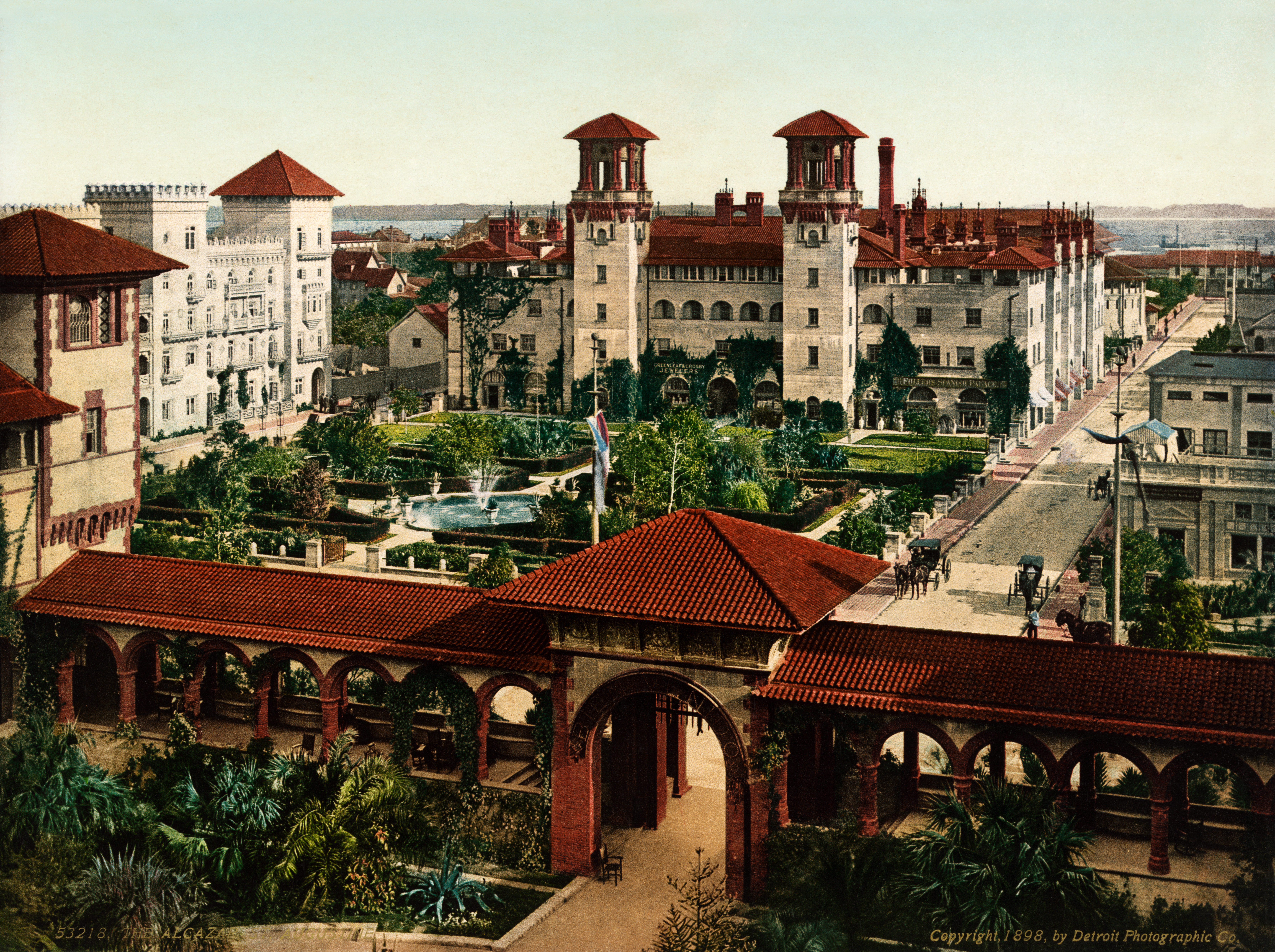 This picture is of the historic Alcazar Hotel, located in St. Augustine, Florida. It is an 1898 photochrome postcard published by the Detroit Photographic Company. This hotel shows the Spanish influence on St. Augustine, Florida.
While Spain governed what is now the southern United States, France ruled Canada and much of the interior of the North American continent. The French first came to Canada in the late 1500s to engage in fishing in the North Atlantic and soon expanded their reach by creating a fur trade in the area surrounding the Great Lakes and throughout the Mississippi River system.
Although there were fewer settlers from France than from other European countries—especially in what became the United States—this French era left behind place names like Baton Rouge and Detroit, patterns of land use, and a French-speaking population in Canada. Despite the early influence of Spain and France in Canada and the United States, most of the population speaks English as their native language because of Britain’s colonial dominance. Jamestown, the earliest permanent British colony, was founded in 1607.
The British built up a successful empire in the New World. Their 13 American colonies became populous, economically robust, and militarily strong enough to gain independence in 1776. Canada functions as an independent country, but it remains part of the British Commonwealth.
 This map illustrates the colonial empire of the English, French, and Spanish in North America.
Population Distribution in North America
The population of the United States surpassed the 325 million mark in 2017. Canada now has over 36 million people. From 2015 to 2016, 2.2 million people were added to the US population. A little less than half of the growth is due to immigration and the rest is to birth rates. The pace of growth is slower than the world average but more rapid than many other industrialized countries such as those in Europe. In fact, the US is the third most populous country in the world.
The population is not uniformly spread over North America. Most Canadians live in proximity to the US border. The North American population tends to be clustered in cities, with about 80 percent of US citizens living in urban and suburban areas. Additionally, over time, the population has been moving southward and westward. States in the US experiencing the greatest rates of population growth include those located on the southern portion of the eastern seaboard, as well as Texas, Nevada, Utah, California, Oregon, and Washington.
Three states—California, Texas, and Florida—account for about one-third of the entire US population growth since 1990. Nonetheless, the Northeast is the most densely populated area of the country. This is due in large part to the megalopolis that forms the corridor from Washington, D.C. to Boston. The largest concentration of Canadians lives in the most southern-reaching province of Ontario. For this reason, Ontario is often referred to as South Canada.
In general, the population of minorities is growing most rapidly. Some of the fastest-growing populations in the United States are Hispanics. Another interesting factor in population growth is the increase in life expectancy. As more people live longer, the growth of the segment of the population aged 65 has doubled in the last 50 years. However, it appears that the growth of this population segment is slowing. Of this group, the greatest increase was seen in people aged 85 years and older.
The American population tends to be on the move, although moving fell to an all-time low according to 2016 data from the US Census Bureau. Data also indicates that Americans will move to a metropolitan area. Urbanization has been a trend since the 1950s. Until that time, most Americans lived in small towns or rural settings. The population density of the cities, especially the suburban areas, has grown steadily since that time, bringing about a rural-to-urban population shift. Now, a significant majority of people in North America live in suburban areas.
Urbanization has brought some challenges. The layout of cities and their suburbs often makes owning a car a necessity. Thus, traffic congestion is a major problem. Other issues that have arisen are overcrowded schools, racial tensions, and a widening economic gap between the rich and the poor. As people move to cities, housing and other resources might not be able to meet demand, forcing prices to be more expensive. The margin between the cost of living in an urban area and the population’s ability to afford it has contributed to poverty and homelessness. Environmental issues also abound, including how to reduce or eliminate smog, manage waste, and ensure clean drinking water.
- The United States and Canada have mountain ranges along their eastern and western portions, with lowlands in the middle.
- In general, temperatures get cooler as you move from south to north, and the climate gets more arid as you move from east to west across the continent.
- The Spanish were the earliest Europeans to establish a permanent settlement in North America. They controlled the territory in the southern edge of what is now the United States, and their influence is still felt today through the Mexican American culture in that region.
- The French colonized eastern Canada, the Great Lakes, and the Mississippi River Valley.
- Although the number of settlers was small outside Quebec, French place names, and French land-use patterns are still evident.
- The British colonized the eastern coast of what became the United States. The number of English-speaking settlers was so high that the English culture dominated the region and left a strong long-term impact in terms of language, religion, and many other cultural aspects.
- The millions of people living in both Canada and the United States are not evenly distributed.
- More of the population continues to migrate into urban areas.
- Minority groups are the fastest-growing segment of the population.
Vocabulary Terms
- cultural convergence: a process of cultures becoming more alike
- cultural diffusion: the process by which culture is spread
- cultural divergence: a process in which cultural groups distinguish themselves from other culture groups
- demographics: statistical data about human populations
- indigenous: originating in a particular region
- megalopolis: a very large urban region consisting of several adjoining cities and suburbs
- migration: movement from one place to another
- multicultural: inclusion of a variety of cultures
- settlement patterns: the spatial distribution of where humans inhabit the Earth
- urbanization: the process of increasing human settlement in cities
Applying Knowledge
Interactive Notebook Activities
List the physiographic regions of Canada and the United States.
- List the two dominant climate patterns in Canada and the United States.
- Identify the three European countries that had the most significant early influence on Canada and the United States.
- Describe the region that the three European countries listed above dominated early on in Canada and the United States.
- Summarize the legacies these three European countries have had in Canada and the United States.
- Map the population distribution of the United States and Canada.
Discussion and Study Questions
- Who were the three main European colonizers of what became the United States and Canada?
- Where was each European colonizer most influential?
- Describe the long-term impacts of each European power in Canada and the United States.
- What is the main reason the Great Plains and the western part of the United States are so arid?
- What three states had the highest population growth since 2000?
- What segment of the population has doubled in the past 50 years?
- What are the current populations of Canada and the United States?
- What problems has urbanization caused in Canada and the United States?
- Why do millions of people move within the United States each year?
- Why do most Canadians live near the US border?
Real-World Geography Exercise
Using Google Maps, locate each one of the places below. Calculate the distance and how long it would take you to drive from your house to each one of these locations (or the nearest metropolis located in the region). Next, using NASA Latitude and Longitude Finder, determine the latitude and longitude for each location. Be prepared to share and discuss your answers.
- Appalachian Highlands
- Canadian Shield
- Great Lakes
- Great Plains
- Atlantic Coastal Plain
- Interior Lowlands
- Intermontane Basins and Plateaus
- Mississippi River
- Pacific Mountains and Valleys
- Rocky Mountains
Mapping Exercise
Seasonal Differences: In this activity, students will analyze the variable patterns of precipitation in South Asia that result from the region’s seasonal monsoon winds. As the students investigate those patterns, they will explore relationships between rainfall and physical features and analyze the climate’s impact on agriculture and population
Videos for Geography Enrichment
Helpful Websites for the Study of Geography
Canadian Encyclopedia is an encyclopedia funded by the Canadian government covering all branches of knowledge. Their scholarly collection includes interactive materials.
CIA World Factbook provides information on the people, history, government, economy, energy, geography, communications, transportation, military, and transnational issues for the world's entities.
Congress.gov is a US government website where you can find federal legislation, past and present, as well as information about the US legal system.
Drug Enforcement Administration (DEA) is a government agency website that provides current news, resources, topics of interest, information about drugs, careers in the DEA, and a tip hotline.
Library of Congress is the largest library in the world and provides manuscripts, files, information, pictures, and videos.
NASA Earth Observatory (NEO) is a US government agency website that allows users to search for and retrieve satellite images of Earth.
National Archives is a US government website that provides historical documents, photos, records, publications, and educator resources.
National Oceanic and Atmospheric Association (NOAA) is a US government agency website that provides weather-related information and ocean research.
National Map is a website by the United States Geological Survey and other federal, state, and local agencies that delivers topographic information for the United States.
NationMaster is a massive central data source and a handy way to graphically compare nations.
Real-Time World Air Quality Index is a website that measures most locations in the world for air pollution in real time.
StateMaster is a unique statistical databas,e which allows you to research and compare a multitude of different data on US states.
United Nations (UN) is an international organization founded in 1945 and made up of 193 member states. The UN maintains international peace and security, protects human rights, delivers humanitarian aid, promotes sustainable development, and upholds international law.
United States Census Bureau is a US government agency that provides a population clock, data, surveys, statistics, a library with information and infographics, news about the economy, and much more.
United States Geological Survey (USGS) is a US government agency website that provides scientific information about the natural hazards that threaten lives, the natural resources we rely on, the health of our ecosystems and environment, and the impacts of climate and land-use change.
Whitehouse.gov is a US government website that provides the latest presidential news, information about the budget, policy, defense, and many more topics.
World Health Organization (WHO) is under the United Nations and provides leadership on matters critical to health, shapes the research agenda on health, and monitors the health situation and assessing health trends around the world. Their website provides information on the state of health around the world, outbreaks, current health news, and more.
World Trade Organization (WTO) is an intergovernmental organization that regulates international trade. The website provides information on the history of the multilateral trading system, featured videos, news and events, trade topics, and more.
| Image | Reference | Attributions |
 |
[Figure 4] | Credit: By Pinpin [GFDL (http://www.gnu.org/copyleft/fdl.html) or CC BY-SA 3.0 (https://creativecommons.org/licenses/by-sa/3.0)], via Wikimedia Commons. Source: By Pinpin [GFDL ( or CC BY-SA 3.0 (creativecommons.org/licenses/by-sa/3.0)]http://www.gnu.org/copyleft/fdl.html) ; via Wikimedia Commons. License: CC BY-NC 3.0 |