
3.2: Early Development and Globalization (2 days)
- Page ID
- 1950
\( \newcommand{\vecs}[1]{\overset { \scriptstyle \rightharpoonup} {\mathbf{#1}} } \)
\( \newcommand{\vecd}[1]{\overset{-\!-\!\rightharpoonup}{\vphantom{a}\smash {#1}}} \)
\( \newcommand{\id}{\mathrm{id}}\) \( \newcommand{\Span}{\mathrm{span}}\)
( \newcommand{\kernel}{\mathrm{null}\,}\) \( \newcommand{\range}{\mathrm{range}\,}\)
\( \newcommand{\RealPart}{\mathrm{Re}}\) \( \newcommand{\ImaginaryPart}{\mathrm{Im}}\)
\( \newcommand{\Argument}{\mathrm{Arg}}\) \( \newcommand{\norm}[1]{\| #1 \|}\)
\( \newcommand{\inner}[2]{\langle #1, #2 \rangle}\)
\( \newcommand{\Span}{\mathrm{span}}\)
\( \newcommand{\id}{\mathrm{id}}\)
\( \newcommand{\Span}{\mathrm{span}}\)
\( \newcommand{\kernel}{\mathrm{null}\,}\)
\( \newcommand{\range}{\mathrm{range}\,}\)
\( \newcommand{\RealPart}{\mathrm{Re}}\)
\( \newcommand{\ImaginaryPart}{\mathrm{Im}}\)
\( \newcommand{\Argument}{\mathrm{Arg}}\)
\( \newcommand{\norm}[1]{\| #1 \|}\)
\( \newcommand{\inner}[2]{\langle #1, #2 \rangle}\)
\( \newcommand{\Span}{\mathrm{span}}\) \( \newcommand{\AA}{\unicode[.8,0]{x212B}}\)
\( \newcommand{\vectorA}[1]{\vec{#1}} % arrow\)
\( \newcommand{\vectorAt}[1]{\vec{\text{#1}}} % arrow\)
\( \newcommand{\vectorB}[1]{\overset { \scriptstyle \rightharpoonup} {\mathbf{#1}} } \)
\( \newcommand{\vectorC}[1]{\textbf{#1}} \)
\( \newcommand{\vectorD}[1]{\overrightarrow{#1}} \)
\( \newcommand{\vectorDt}[1]{\overrightarrow{\text{#1}}} \)
\( \newcommand{\vectE}[1]{\overset{-\!-\!\rightharpoonup}{\vphantom{a}\smash{\mathbf {#1}}}} \)
\( \newcommand{\vecs}[1]{\overset { \scriptstyle \rightharpoonup} {\mathbf{#1}} } \)
\( \newcommand{\vecd}[1]{\overset{-\!-\!\rightharpoonup}{\vphantom{a}\smash {#1}}} \)
\(\newcommand{\avec}{\mathbf a}\) \(\newcommand{\bvec}{\mathbf b}\) \(\newcommand{\cvec}{\mathbf c}\) \(\newcommand{\dvec}{\mathbf d}\) \(\newcommand{\dtil}{\widetilde{\mathbf d}}\) \(\newcommand{\evec}{\mathbf e}\) \(\newcommand{\fvec}{\mathbf f}\) \(\newcommand{\nvec}{\mathbf n}\) \(\newcommand{\pvec}{\mathbf p}\) \(\newcommand{\qvec}{\mathbf q}\) \(\newcommand{\svec}{\mathbf s}\) \(\newcommand{\tvec}{\mathbf t}\) \(\newcommand{\uvec}{\mathbf u}\) \(\newcommand{\vvec}{\mathbf v}\) \(\newcommand{\wvec}{\mathbf w}\) \(\newcommand{\xvec}{\mathbf x}\) \(\newcommand{\yvec}{\mathbf y}\) \(\newcommand{\zvec}{\mathbf z}\) \(\newcommand{\rvec}{\mathbf r}\) \(\newcommand{\mvec}{\mathbf m}\) \(\newcommand{\zerovec}{\mathbf 0}\) \(\newcommand{\onevec}{\mathbf 1}\) \(\newcommand{\real}{\mathbb R}\) \(\newcommand{\twovec}[2]{\left[\begin{array}{r}#1 \\ #2 \end{array}\right]}\) \(\newcommand{\ctwovec}[2]{\left[\begin{array}{c}#1 \\ #2 \end{array}\right]}\) \(\newcommand{\threevec}[3]{\left[\begin{array}{r}#1 \\ #2 \\ #3 \end{array}\right]}\) \(\newcommand{\cthreevec}[3]{\left[\begin{array}{c}#1 \\ #2 \\ #3 \end{array}\right]}\) \(\newcommand{\fourvec}[4]{\left[\begin{array}{r}#1 \\ #2 \\ #3 \\ #4 \end{array}\right]}\) \(\newcommand{\cfourvec}[4]{\left[\begin{array}{c}#1 \\ #2 \\ #3 \\ #4 \end{array}\right]}\) \(\newcommand{\fivevec}[5]{\left[\begin{array}{r}#1 \\ #2 \\ #3 \\ #4 \\ #5 \\ \end{array}\right]}\) \(\newcommand{\cfivevec}[5]{\left[\begin{array}{c}#1 \\ #2 \\ #3 \\ #4 \\ #5 \\ \end{array}\right]}\) \(\newcommand{\mattwo}[4]{\left[\begin{array}{rr}#1 \amp #2 \\ #3 \amp #4 \\ \end{array}\right]}\) \(\newcommand{\laspan}[1]{\text{Span}\{#1\}}\) \(\newcommand{\bcal}{\cal B}\) \(\newcommand{\ccal}{\cal C}\) \(\newcommand{\scal}{\cal S}\) \(\newcommand{\wcal}{\cal W}\) \(\newcommand{\ecal}{\cal E}\) \(\newcommand{\coords}[2]{\left\{#1\right\}_{#2}}\) \(\newcommand{\gray}[1]{\color{gray}{#1}}\) \(\newcommand{\lgray}[1]{\color{lightgray}{#1}}\) \(\newcommand{\rank}{\operatorname{rank}}\) \(\newcommand{\row}{\text{Row}}\) \(\newcommand{\col}{\text{Col}}\) \(\renewcommand{\row}{\text{Row}}\) \(\newcommand{\nul}{\text{Nul}}\) \(\newcommand{\var}{\text{Var}}\) \(\newcommand{\corr}{\text{corr}}\) \(\newcommand{\len}[1]{\left|#1\right|}\) \(\newcommand{\bbar}{\overline{\bvec}}\) \(\newcommand{\bhat}{\widehat{\bvec}}\) \(\newcommand{\bperp}{\bvec^\perp}\) \(\newcommand{\xhat}{\widehat{\xvec}}\) \(\newcommand{\vhat}{\widehat{\vvec}}\) \(\newcommand{\uhat}{\widehat{\uvec}}\) \(\newcommand{\what}{\widehat{\wvec}}\) \(\newcommand{\Sighat}{\widehat{\Sigma}}\) \(\newcommand{\lt}{<}\) \(\newcommand{\gt}{>}\) \(\newcommand{\amp}{&}\) \(\definecolor{fillinmathshade}{gray}{0.9}\)- Explain how the United States acquired its geographic boundaries.
- List patterns of immigration to and migration within the United States through the period of westward settlement.
- Describe urban growth and its connection to development of new forms of transportation.
- Explain which economic patterns helped the United States become the world’s largest economy.
- Describe how the concept of the American Dream has been exported globally.
TEKS Regional Unit 03: United States and Canada Chapter 3.2
WG.5B Interpret political, economic, social, and demographic indicators (gross domestic product per capita, life expectancy, literacy, and infant mortality) to determine the level of development and standard of living in nations using the terms Human Development Index, less developed, newly industrialized, and more developed
WG.6A Locate and describe human and physical features that influence the size and distribution of settlements
WG.6B Explain the processes that have caused changes in settlement patterns, including urbanization, transportation, access to and availability of resources, and economic activities
WG.9A Identify physical and/or human factors such as climate, vegetation, language, trade networks, political units, river systems, and religion that constitute a region
WG.10D Compare global trade patterns over time and examine the implications of globalization, including outsourcing and free trade zones
WG.11A Understand the connections between levels of development and economic activities (primary, secondary, tertiary, and quaternary)
WG.11B Identify the factors affecting the location of different types of economic activities, including subsistence and commercial agriculture, manufacturing, and service industries
WG.11C Assess how changes in climate, resources, and infrastructure (technology, transportation, and communication) affect the location and patterns of economic activities
WG.12A how the creation, distribution, and management of key natural resources affects the location and patterns of movement of products, money, and people
WG.13A Interpret maps to explain the division of land, including man-made and natural borders, into separate political units such as cities, states, or countries
WG.14C Analyze current events to infer the physical and human processes that lead to the formation of boundaries and other political divisions
WG.16A Describe distinctive cultural patterns and landscapes associated with different places in Texas, the United States, and other regions of the world and how these patterns influenced the processes of innovation and diffusion.
WG.16D Compare life in a variety of urban and rural areas in the world to evaluate political, economic, social, and environmental changes
WG.18D Evaluate the spread of cultural traits to find examples of cultural convergence and divergence such as the spread of democratic ideas, US-based fast-food franchises, the English language, technology, or global sports.
WG.19A Evaluate the significance of major technological innovations in the areas of transportation and energy that have been used to modify the physical environment
United States: Early Development and Globalization
Early Development Patterns
Canada and the United States is divided into a number of physical regions with distinct landforms. The western part of the continent is marked by north-south mountain ranges in the Rocky Mountains and Pacific Mountains and Valley's physiographic provinces, with the Intermontane Basins and Plateaus in between. The eastern portion of the United States is defined by the ancient Appalachian Mountains, a mountain range that is much less rugged than the Rockies but with no less influence on the history and development of this region. The interior of North America is characterized by plains—the Interior Lowlands and the Great Plains. To the north is the Canadian Shield, geologically the oldest part of North America, and a sparsely populated area with poor soils. At the southern and eastern edge of the continent is the Atlantic Coastal Plain, a relatively flat zone that extends from New York to Texas.
Manifest Destiny
The concept of Manifest Destiny came from the works of John O’Sullivan in 1839. O’Sullivan wrote, "The far-reaching, the boundless future will be the era of American greatness. In its magnificent domain of space and time, the nation of many nations is destined to manifest to mankind the excellence of divine principles; to establish on earth the noblest temple ever dedicated to the worship of the Most High—the Sacred and the True. Its floor shall be a hemisphere—its roof the firmament of the star-studded heavens, and its congregation an Union of many Republics, comprising hundreds of happy millions, calling, owning no man master, but governed by God’s natural and moral law of equality, the law of brotherhood—of “peace and good will amongst men” (John L. O'Sullivan on Manifest Destiny, 1839).
As the United States developed, it acquired external colonial possessions. With the victory over Spain in the Spanish-American War of 1898, the US government gained control of the Philippines, Cuba, Puerto Rico, Guam, and various Pacific islands. Cuba and the Philippines later became independent countries, but Puerto Rico and Guam continue to be part of the United States. The US Virgin Islands were purchased from Denmark in 1918 after World War I as a location to provide strategic military support to protect the shipping lanes through the Caribbean and the Panama Canal.
Westward Settlement Patterns and European Immigration
The 13 original colonies are often grouped into three regions, each with its own economic and cultural patterns. These three areas—New England, the Mid-Atlantic, and the South—are considered culture hearths, or places where culture formed and from which it spread. The three regions were source areas for westward migration, and migrants from these regions carried with them the cultural traditions of their culture hearths. The New England colonies were characterized by poor soils, subsistence agriculture, and fishing communities. They were also the birthplace of North America’s Industrial Revolution. Boston was the largest city in the region.
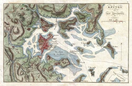 This is a photographic reproduction of an 1807 map of Boston and its immediate vicinity drawn by J. N. Buache for inclusion in the 1807 French edition of Marshall's Life of Washington.
Settlers from New England traveled west across New York State and into the upper Midwest and the Great Lakes region. The Mid-Atlantic region, focused on Philadelphia, Pennsylvania, was known for its fertile soils, prosperous small-scale agriculture, and multinational population. Prosperous farming led to a vibrant economy and a robust network of towns and cities. People who migrated west from this region traveled down the Great Valley into the Appalachian Mountains and across the Cumberland Gap into Kentucky, or they crossed Pennsylvania and traveled west via the Ohio River valley. The heart of the South was Virginia, a region oriented around plantation agriculture. The South was overwhelmingly rural, and in time the bulk of its agricultural workforce consisted of slaves brought to the United States from Sub-Saharan Africa.
Westward migration was spurred along by the California Gold Rush of 1849 and by the completion of the Transcontinental Railroad in 1869. The settlement frontier pushed westward during the course of the 19th century and was declared “closed” by the Bureau of the Census in 1890. This did not mean that settlers were spread uniformly across the continent by 1890. Vast areas of the Great Plains and the mountain west remained sparsely populated by Europeans at that time. The Homestead Act of 1862 also encouraged westward migration by offering 160 acres of free land to households willing to move west. The continental United States had been organized into official states by the end of the 19th century with the exception of Oklahoma, Arizona, and New Mexico.
Most US residents at the beginnings of the country in 1776 had roots in Great Britain. Large numbers were also from other northern and western European countries. Moreover, the south had a substantial population from Africa, most of whom were slaves. During the 19th century, migrants continued to immigrate to the United States as its economy grew, especially after the 1830s. The German and Irish began arriving in large numbers, joining others from Britain and other countries.
As the century progressed, immigrants from Italy, Russia, and Austria came to the United States in masses. The new arrivals were different from the early British immigrants. They practiced Roman Catholic or Eastern Orthodox Christianity. They primarily moved to urban areas, and they found work in the new manufacturing sector growing rapidly in the Northeast and around the Great Lakes. Very few immigrants came from Latin America or Asia at that time. For a more detailed history of immigration in the United States, go to the Statue of Liberty - Ellis Island Immigration Timeline website.
Industrial Development and Urbanization
The Industrial Revolution that began in Great Britain in the late 18th century eventually moved across the Atlantic and took hold in the United States. Rapid industrial growth emerged in the 19th century and was focused in the northeastern United States around the Great Lakes. This area is called the Manufacturing Belt. Mechanized manufacturing began with textiles in New England. Then it moved to steel and other metals in Pennsylvania and Indiana. Later, it was dominated by the manufacturing of automobiles in Michigan. Manufacturing would not have been possible without an abundant supply of power. Coal mining became an important industry in western Pennsylvania and in Appalachia.
Manufacturing took place in the cities and towns of the Manufacturing Belt. Not until the second half of the 20th century did manufacturing move to rural areas. Until then, it was almost entirely an urban activity. As the United States went through its Industrial Revolution, the population shifted from being almost entirely rural to being mostly urban. In 1790, only about 5 percent of the US population lived in urban areas. By 1920, about 50 percent lived in cities. As the rural to urban shift took place, the function and form of US cities also changed.
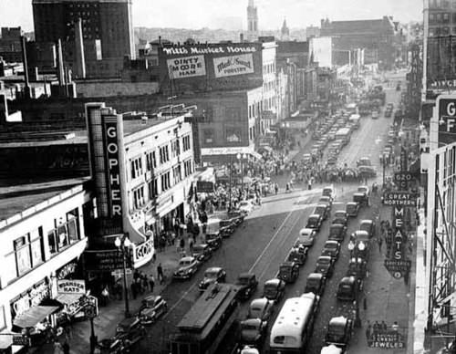
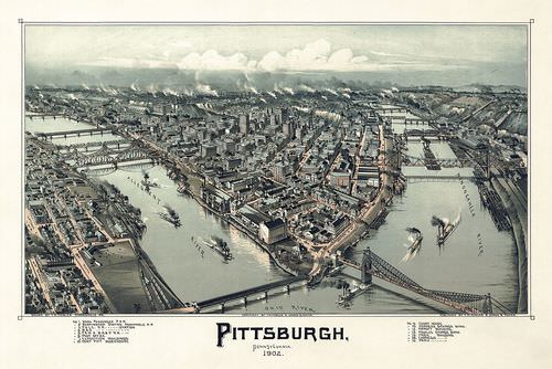 Pittsburgh, Pennsylvania was an important city in the Manufacturing Belt in the 1900s.
From the colonial era until the late 19th century, US cities were walking cities. Because most Americans lived on farms, cities were small, compact, and centrally located as well as most activities were within walking distance. Only wealthy people had access to transportation by horse. City dwellers needed to live within a short distance of where they worked, shopped, and lived their daily lives.
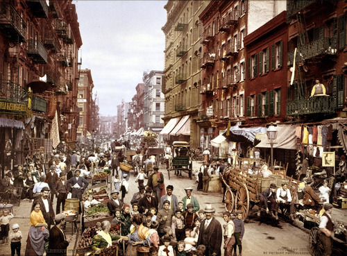
This photograph was taken on Mulberry Street on the Lower East Side in New York City in the early 1900s. It depicts a walking city.
The invention of the electric streetcar in 1888 allowed cities to increase in size. People could live farther from their place of employment as long as they lived within walking distance of a streetcar line. Streetcar suburbs grew up along streetcar lines. These neighborhoods were often segregated by ethnicity and race. Fewer people lived in downtown areas, which became dedicated to retail and manufacturing. Cities remained oriented around a Central Business District (CBD), which was often located near the railway station. Factories needed to be near modes of transportation for both shipping in parts and shipping out completed products so that workers could easily get to work.
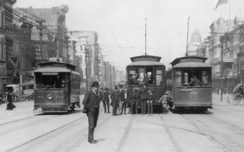
This picture of three street cars in New Orleans, Louisiana, shows the prevalence of street cars in the early 1900s.
Large numbers of middle-class Americans began acquiring automobiles after 1920. This eventually led to a complete rethinking of the spatial layout of cities. Automobile suburbs sprang up outside the traditional city limits as people were able to buy homes far from streetcar lines or railway stations. Cities became increasingly decentralized. People could go shopping in suburban malls instead of downtown department stores.
Factories could be built at highway interchanges and not just near rivers and railroads. People could live in one suburb and work in another, instead of living in the suburbs and working downtown. Neighborhoods became even more racially and economically segregated than they had in the past, as middle-class whites moved into the new suburbs. Economically disadvantaged African Americans were left behind in the urban cores.
 By the 1940s, the car culture was taking hold. This picture was taken in Minneapolis, Minnesota, in 1940.
By the late 20th century, the automobile had led to a new urban form called the "edge city". Edge cities are areas of dense urban development outside the boundaries of traditional cities. They often form at the intersection of major interstate highways and contain shopping malls, office complexes, high-rise apartment buildings, industrial parks, restaurants, and hotels. Sometimes edge cities are called suburban downtowns. Edge cities have supplanted the CBD as the place Americans call home.
Economic Changes
For the purpose of understanding economic geography, all economic activities can be grouped into one of four categories, each with its respective terms, depending on the nature of what is being produced:
- Primary economic sector activities include everything that pertains to the collection of raw materials, such as agriculture, forestry, fishing, and mining.
- Secondary economic sector activities involve the processing of those raw materials through manufacturing.
- Tertiary economic sector activities are those that produce services, not physical products.
- Quaternary economic sector activities are those that deal with information collecting and processing, as well as management.
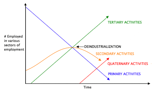 Clark's Sector Model illustrates the trends of the different economic sectors. With industrialization, the primary sector is in a decline and the tertiary sector is on an incline.
The tertiary and quaternary economic sectors are often thought of together as the service sector. In the explanation of how countries gain national income, only primary and secondary activities produce actual physical products. Manufacturing traditionally earns the highest value-added profits. Tertiary activities are selective in gaining national wealth. For example, service activities such as tourism can bring in national wealth if the visitors are from outside the country. Tourism within a country can also influence economic conditions by increasing the amount of consumer spending.
During the colonial era and into the 19th century, when the majority of Americans lived on farms and worked in agriculture, most economic activity in the United States took place within the primary economic sector. Today, the primary sector is still an important component of the US economy, but far fewer people are employed in it. For example, less than 1 percent of Americans make their living by farming, but agricultural output has continued to grow because of advancements in mechanization and the development of high-tech seeds, fertilizers, and pesticides. The United States has been able to export surplus agricultural output to other parts of the world. Fewer people work in coal mines than in the past, but because of new mining technologies and methods such as mountaintop removal, coal production remains high.
The geographic distribution of primary activities depends both on the location of natural features such as physical geography and climate and on the location of the market for a particular crop or resource. The 19th-century German economist Johann von Thünen created a model that predicted land use around a central market. In his theory, the land closest to the market would be used to produce crops that were expensive to transport, such as dairy. Land far from the market would be used for the production of crops that were less expensive to transport and less perishable, such as grain.
 This diagram shows the Von Thünen's model of distribution of different types of farming at different distances from a city.
The Von Thünen model predicts a series of concentric rings surrounding a central market, with each ring producing a different kind of crop. If the Von Thünen model is applied at a much larger scale to the United States as a whole, with the densely populated urban zone from Boston to Washington, D.C., the model is fairly accurate in predicting the United States’ agricultural land use. Dairy farms are found close to the market, grain farms are farther away, and ranch lands used for livestock production are even farther away.
Anything that involves the processing of raw materials, known as manufacturing, is a secondary activity. As the United States moved into the Industrial Revolution and into the mid-20th century, the percentage of the US workforce involved in manufacturing grew from almost nothing until it peaked in the late 1970s. It was the main area of economic growth for decades.
Although manufacturing was present in most areas of the country, it was focused in the northeastern United States and along the Great Lakes. Factories were close both to the reserves of labor and to the markets for manufactured products found in the densely populated Northeast. The steel industry was located in Pittsburgh and its environs because of the area’s access to raw materials. Iron ore was mined in Minnesota and transported via the Great Lakes. Coal was mined in Pennsylvania, West Virginia, and other parts of Appalachia.
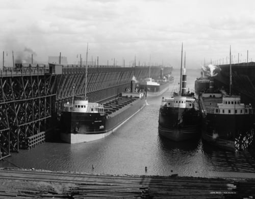
Ore docks of the Duluth, Missabe and Northern Railway loading ships in Duluth, Minnesota. The ship at the left front is George H. Russel, launched 1905, in Ecorse, Michigan. This picture was taken between 1900 and 1915.
As manufacturing has grown in other parts of the world, the secondary economic sector has declined in the United States. US labor statistics indicate that the United States lost about five million manufacturing jobs between 2000 and 2010. Many of these jobs were lost to countries with lower labor costs, such as Mexico or China.
The third group of economic activities takes place in the tertiary and quaternary sectors, known as the service sector. Tertiary and quaternary activities create services, not physical products. Service jobs include everything from engineering to finance, restaurants to sports, and childcare to medicine. The tertiary sector makes up more than three-quarters of the US economy, as measured by its share of the gross domestic product (GDP), which is the total value of all goods and services produced in a country in a given year. The GDP is then divided by the country’s population to provide a GDP per capita statistic. Current data for GDP composition by Industry for the United States can be accessed at the US Bureau of Economic Analysis.
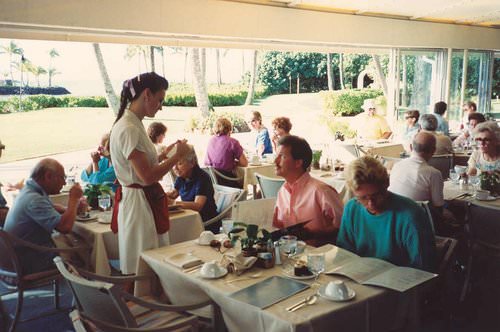
This picture of a waitress taking an order at Kahala Hilton Hotel in Hawaii is an example of a service job in the tertiary sector.
These figures show that the United States has shifted to a postindustrial service economy. The rise of the information age in the latter part of the 20th century shifted the workforce into the information sector. By the beginning of the 21st century, less than 2 percent of the US workforce was employed in agriculture, 15 percent in industry, 18 percent in services, and 65 percent in information activities.

This picture of engineers programming on computers is an example of the quaternary sector.
The locations of service-sector jobs are much more flexible than are jobs in the primary or secondary sectors. Another term for service-sector jobs is footloose jobs. For example, an accountant can live in New York or in Denver. Whereas it is much more difficult for factories to move from one place to another, and it is impossible for farms to relocate. Many of the information-technology jobs are emerging in the southern regions of the United States called the Sun Belt. Southern cities such as Atlanta, Dallas, and Phoenix are centers of innovation and population growth.
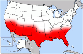
This map of the United States with the area highlighted in red depicts the Sun Belt.
The warmer climate, combined with a lower cost of living and less congestion, makes the Sun Belt an attractive location for emerging information-based companies. Note that the popularity of the South and West for service-sector jobs only came about after the invention and adoption of air-conditioning. Air-conditioning was not widespread until after World War II in the 1950s.
While the population of the Southern states has increased, the population of some Northern states has decreased. The Sun Belt has always been a destination for people escaping the harsh winters of the Northern states. This has usually been only a seasonal transition. However, the new trend is one of permanent growth because of the increase in information technologies and in the service industry. Emerging companies looking to establish their businesses have targeted major cities from the Carolinas to the Southwest.
Houston, Texas is an example of a city in which companies and people are moving. According to the worldpopulationreview.com website, Houston is the fourth largest city in the United States and the largest in Texas. Currently, the population in Houston is more than 2.2 million people and rapidly growing. It is a global and multicultural city, and only New York City has more Fortune 500 company headquarters.

Houston is the 4th largest city in the US and the largest in Texas. Only New York City has more Fortune 500 company headquarters.
Migration Patterns
The United States has undergone a massive rural-to-urban shift in its population. Moreover, intermigration within the United States from one region to another has also been prevalent. Each of the US regions has witnessed changes in demographics because of migration patterns.
In the agricultural regions of the United States, such as the Midwest, the migration pattern has been caused by changes in farm technology. Portions of the United States were opened up for agriculture because of the Homestead Act of 1862, where each person was given 160 acres from the government to start a farm. They could keep the acres if they lived on them and farmed them for a period of years. In the 1800s, 160 acres was enough land to support a family if environmental conditions were good.
The Industrial Revolution brought about improved farm equipment and technology. Larger and more expensive tractors and improved farming methods pushed the small farmers to sell out. Farms increased in size and fewer people were required to operate them. Since fewer farm workers are needed in rural areas, there has been a major rural-to-urban shift in the population. Central cities are increasing in population, while small towns and rural areas in the Midwest and across the nation are decreasing in population.
Americanism and Globalization
The freedom of personal expression in the United States has supported individual ingenuity to create the largest economy in the world. Citizens of the United States have pushed American corporations to become a major force in the world markets. Products and franchises from the US are distributed throughout the world. Items such as fast food, computers, news networks, and Hollywood movies have become the products of choice in countries across the globe.
 McDonald's has fast-food restaurants all over the world. This McDonald's operates in Moscow, Russia.
The English language dominates the Internet, which has been heavily influenced by US corporations. The power of the American Dream—the idea that through hard work anyone can achieve upward mobility and financial success—as it is portrayed in the US media, holds sway in the minds of people in the United States and abroad.
News networks in the United States are so dominant that small countries, having no resources to create networks, rely on the US networks to deliver their news. Fast food franchises from the US exist in over 100 countries. Despite humble beginnings in Arkansas, Walmart grew to become the world’s largest corporation. It has become the buyer and seller of retail trade that shapes and molds cultural attitudes and fashions internationally.
The size of the US population and the country’s vast resources have allowed it to become a world military superpower. After the fall of the Soviet Union, the United States became the most powerful military force in the world. The United States has also dominated the world’s economy and its communications networks. The advancements of multinational corporations have in essence enabled the sale of America to the rest of the world. The selling of American products and the large consumer market in the United States have provided the profits that have fueled global economic markets.
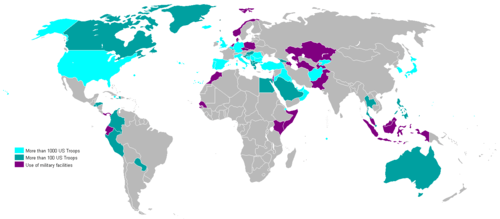
This 2007 world map shows the locations of US military bases.
The United States has become a worldwide franchise of its own. Corporate colonialism has advanced the American brand to a level that is now synonymous with consumerism, success, and power, worldwide. The reaction of the global community includes both admiration and disdain. Many view Americanism as interchangeable with globalization. Some welcome it; others reject it. The country of Iran is an example of this dichotomy. Young people in Iran wearing blue jeans gather in secret to watch American television programming from a hidden illegal satellite dish, while at the same time the anti-American forces in their government condemn America as decadent and imperialistic.
Corporate colonialism has become a dominant force impacting the global cultural fabric. Supporters appreciate access to American goods and services, while opponents claim that the English language and the American corporate franchise system are destroying the culture and heritage of untold millions who see their unique traditional ways of life being overshadowed and destroyed.
Some argue that American television advertisements promote conformity and uniformity in American culture. They contend that America’s unique cultural diversity, which historically has provided originality is being eroded by the franchising of similar retail products, fast food, professional sports, and Hollywood entertainment that stifle the creative will of the American people. Others continue to see opportunities to pursue the American Dream and believe that innovation and ideas continue to emerge in spite of these trends.
Many people worry about the future of the American Dream. American culture continues to evolve as people face changing economic and social conditions. Over the course of their history, Americans have faced both difficult and prosperous times, and now the future of this vibrant country is in the hands of the current generation. The United States has developed into one of the most powerful countries on the planet. Will the American Dream continue to motivate people in the future? Only time will tell.
- The United States’ territory expanded gradually through various treaties and land acquisitions and was influenced by the concept of Manifest Destiny.
- The three main colonial regions in the United States—New England, the Mid-Atlantic, and the South—had their own distinct economic foundations, settlement patterns, and social structures. People from these regions moved westward in particular migration patterns.
- In the beginning of the 19th century, most immigrants were from western and northern Europe.
- By the end of the 19th century and the beginning of the 20th century, immigrants were coming in large numbers from southern and Eastern Europe and moving to industrial cities of the Northeast.
- City structure changed from the walking cities of colonial America, to the railroad and streetcar cities of the late 19th century, to the automobile cities of the mid- and late-20th century.
- The US economy was initially based in the primary economic sector (particularly farming), then was based in the secondary economic sector (manufacturing), and is now oriented around the tertiary and quaternary economic sectors (services and information).
- The diverse immigrants who have created American society have been unified by common aspirations and common ideals that created the concept of the American Dream. The concept indicates that regardless of one’s station in life, by working hard, applying oneself, and following the rules, one can obtain upward economic mobility.
Vocabulary Terms
Appalachian Mountains A mountain range that stretches from eastern Canada south to Alabama
cash crop Crops grow to be sold (examples are indigo, tobacco, cotton)
diversity A variety or a wide range of differences
Mid-Atlantic Region New York, New Jersey, Pennsylvania, Delaware
subsistence farming farmers produced just enough food for themselves and sometimes a little extra to trade in town
Applying Knowledge
Discussion and Study Questions
- What did “Manifest Destiny” mean for the United States?
- From what European region did most early 19th century immigrants come? How did that change by the end of the 19th century?
- How did modes of transportation affect the layout of American cities?
- What is an edge city, and how did edge cities form?
- How does the Von Thünen model relate to the spatial pattern of land use in the United States?
- How have economic sectors shifted in the United States in the past two hundred years?
- What is the American Dream, and how has it been expanded globally?
- What has been the major migration pattern in the Midwest region of the United States? Why is this occurring?
- What part of the United States has been a target for the location of the information age–based businesses? What was the role of air-conditioning technology in making this possible?
- Outline some examples of how US culture influences the rest of the world.
- Explain how the United States acquired its geographic boundaries.
- List patterns of immigration to and migration within the United States through the period of westward settlement.
- Describe urban growth and its connection to the development of new forms of transportation.
- Explain which economic patterns helped the United States become the world’s largest economy.
- Describe how the concept of the American Dream has been exported globally.
Real-World Geography Exercise
Using Google Maps, find a megalopolis located in one of the regions from the list below. Calculate the distance and how long it would take you to drive from your house to each one of these locations. Next, using NASA Latitude and Longitude Finder, determine the latitude and longitude for each megalopolis you chose.
- Cumberland Gap
- Great Valley
- Manufacturing Belt
- Midwest
- Original thirteen colonies
- Sun Belt
Mapping Exercise
USA Demographics: Students will explore US census data to see the spatial differences in the United States’ population. The activity uses a web-based map
Videos for Geography Enrichment
Helpful Websites for the Study of Geography
Canadian Encyclopedia is an encyclopedia funded by the Canadian government covering all branches of knowledge. Their scholarly collection includes interactive materials.
CIA World Factbook provides information on the people, history, government, economy, energy, geography, communications, transportation, military, and transnational issues for the world's entities.
Congress.gov is a US government website where you can find federal legislation, past and present, as well as information about the US legal system.
Drug Enforcement Administration (DEA) is a government agency website that provides current news, resources, topics of interest, information about drugs, careers in the DEA, and a tip hotline.
Library of Congress is the largest library in the world and provides manuscripts, files, information, pictures, and videos.
NASA Earth Observatory (NEO) is a US government agency website that allows users to search for and retrieve satellite images of Earth.
National Archives is a US government website that provides historical documents, photos, records, publications, and educator resources.
National Oceanic and Atmospheric Association (NOAA) is a US government agency website that provides weather-related information and ocean research.
National Map is a website by the United States Geological Survey and other federal, state, and local agencies that delivers topographic information for the United States.
NationMaster is a massive central data source and a handy way to graphically compare nations.
Real-Time World Air Quality Index is a website that measures most locations in the world for air pollution in real time.
StateMaster is a unique statistical database, which allows you to research and compare a multitude of different data on US states.
United Nations (UN) is an international organization founded in 1945 and made up of 193 member states. The UN maintains international peace and security, protects human rights, delivers humanitarian aid, promotes sustainable development, and upholds international law.
United States Census Bureau is a US government agency that provides a population clock, data, surveys, statistics, a library with information and infographics, news about the economy, and much more.
United States Geological Survey (USGS) is a US government agency website that provides scientific information about the natural hazards that threaten lives, the natural resources we rely on, the health of our ecosystems and environment, and the impacts of climate and land-use change.
Whitehouse.gov is a US government website that provides the latest presidential news, information about the budget, policy, defense, and many more topics.
World Health Organization (WHO) is under the United Nations and provides leadership on matters critical to health, shapes the research agenda on health, and monitors the health situation and assessing health trends around the world. Their website provides information on the state of health around the world, outbreaks, current health news, and more.
World Trade Organization (WTO) is an intergovernmental organization that regulates international trade. The website provides information on the history of the multilateral trading system, featured videos, news and events, trade topics, and more.
| Image | Reference | Attributions |
|
[Figure 3] | Credit: See page for author [Public domain], via Wikimedia Commons Source: https://commons.wikimedia.org/wiki/File:Mulberry_Street_NYC_c1900_LOC_3g04637u_edit.jpg License: CC BY-NC 3.0 |
|
[Figure 4] | Credit: By Photographer not credited. [Public domain], via Wikimedia Commons Source: commons.wikimedia.org/wiki/File:CanalMagazineStreetcarsPrytaniaAnnunciation.jpg License: CC BY-NC 3.0 |
 |
[Figure 7] | Credit: By Ytx21cn [CC0], via Wikimedia Commons Source: commons.wikimedia.org/wiki/File:Von_Thunen_Model.svg License: CC BY-NC 3.0 |
|
[Figure 8] | Credit: By Detroit Publishing Co. [Public domain], via Wikimedia Commons Source: commons.wikimedia.org/wiki/File:Duluth_Ore_Docks.jpg License: CC BY-NC 3.0 |
|
[Figure 9] | Credit: photo by Alan Light [CC BY 2.0 (https://creativecommons.org/licenses/by/2.0)], via Wikimedia Commons Source: commons.wikimedia.org/wiki/File:Waitress_taking_an_order.jpg License: CC BY-NC 3.0 |
|
[Figure 10] | Credit: By Vajrapani666 [GFDL (http://www.gnu.org/copyleft/fdl.html) or CC BY-SA 3.0 (https://creativecommons.org/licenses/by-sa/3.0)], from Wikimedia Commons Source: commons.wikimedia.org/wiki/File:Pair_Programming_3.jpg License: CC BY-NC 3.0 |
|
[Figure 11] | Credit: Public domain map courtesy of [http://www.lib.utexas.edu/ The General Libraries, The University of Texas at Austin], modified (by • Benc • 00:36, 13 Aug 2004 (UTC)) to highlight regions via Wikimedia Commons Source: upload.wikimedia.org/Wikipedia/commons/c/c3/Map_of_USA_highlighting_Sun_Belt.png License: CC BY-NC 3.0 |
|
[Figure 12] | Credit: By Henry Han [CC BY-SA 3.0 (https://creativecommons.org/licenses/by-sa/3.0)], from Wikimedia Commons Source: commons.wikimedia.org/wiki/File:Uptown_Houston.jpg License: CC BY-NC 3.0 |
|
[Figure 14] | Credit: By Tree Sign at English Wikipedia (Transferred from en.Wikipedia to Commons.) [Public domain], via Wikimedia Commons Source: commons.wikimedia.org/wiki/File:US_military_bases_in_the_world_2007.PNG License: CC BY-NC 3.0 |