
3.3: Regions of the United States and Canada (2 Days)
- Page ID
- 1953
\( \newcommand{\vecs}[1]{\overset { \scriptstyle \rightharpoonup} {\mathbf{#1}} } \)
\( \newcommand{\vecd}[1]{\overset{-\!-\!\rightharpoonup}{\vphantom{a}\smash {#1}}} \)
\( \newcommand{\id}{\mathrm{id}}\) \( \newcommand{\Span}{\mathrm{span}}\)
( \newcommand{\kernel}{\mathrm{null}\,}\) \( \newcommand{\range}{\mathrm{range}\,}\)
\( \newcommand{\RealPart}{\mathrm{Re}}\) \( \newcommand{\ImaginaryPart}{\mathrm{Im}}\)
\( \newcommand{\Argument}{\mathrm{Arg}}\) \( \newcommand{\norm}[1]{\| #1 \|}\)
\( \newcommand{\inner}[2]{\langle #1, #2 \rangle}\)
\( \newcommand{\Span}{\mathrm{span}}\)
\( \newcommand{\id}{\mathrm{id}}\)
\( \newcommand{\Span}{\mathrm{span}}\)
\( \newcommand{\kernel}{\mathrm{null}\,}\)
\( \newcommand{\range}{\mathrm{range}\,}\)
\( \newcommand{\RealPart}{\mathrm{Re}}\)
\( \newcommand{\ImaginaryPart}{\mathrm{Im}}\)
\( \newcommand{\Argument}{\mathrm{Arg}}\)
\( \newcommand{\norm}[1]{\| #1 \|}\)
\( \newcommand{\inner}[2]{\langle #1, #2 \rangle}\)
\( \newcommand{\Span}{\mathrm{span}}\) \( \newcommand{\AA}{\unicode[.8,0]{x212B}}\)
\( \newcommand{\vectorA}[1]{\vec{#1}} % arrow\)
\( \newcommand{\vectorAt}[1]{\vec{\text{#1}}} % arrow\)
\( \newcommand{\vectorB}[1]{\overset { \scriptstyle \rightharpoonup} {\mathbf{#1}} } \)
\( \newcommand{\vectorC}[1]{\textbf{#1}} \)
\( \newcommand{\vectorD}[1]{\overrightarrow{#1}} \)
\( \newcommand{\vectorDt}[1]{\overrightarrow{\text{#1}}} \)
\( \newcommand{\vectE}[1]{\overset{-\!-\!\rightharpoonup}{\vphantom{a}\smash{\mathbf {#1}}}} \)
\( \newcommand{\vecs}[1]{\overset { \scriptstyle \rightharpoonup} {\mathbf{#1}} } \)
\( \newcommand{\vecd}[1]{\overset{-\!-\!\rightharpoonup}{\vphantom{a}\smash {#1}}} \)
\(\newcommand{\avec}{\mathbf a}\) \(\newcommand{\bvec}{\mathbf b}\) \(\newcommand{\cvec}{\mathbf c}\) \(\newcommand{\dvec}{\mathbf d}\) \(\newcommand{\dtil}{\widetilde{\mathbf d}}\) \(\newcommand{\evec}{\mathbf e}\) \(\newcommand{\fvec}{\mathbf f}\) \(\newcommand{\nvec}{\mathbf n}\) \(\newcommand{\pvec}{\mathbf p}\) \(\newcommand{\qvec}{\mathbf q}\) \(\newcommand{\svec}{\mathbf s}\) \(\newcommand{\tvec}{\mathbf t}\) \(\newcommand{\uvec}{\mathbf u}\) \(\newcommand{\vvec}{\mathbf v}\) \(\newcommand{\wvec}{\mathbf w}\) \(\newcommand{\xvec}{\mathbf x}\) \(\newcommand{\yvec}{\mathbf y}\) \(\newcommand{\zvec}{\mathbf z}\) \(\newcommand{\rvec}{\mathbf r}\) \(\newcommand{\mvec}{\mathbf m}\) \(\newcommand{\zerovec}{\mathbf 0}\) \(\newcommand{\onevec}{\mathbf 1}\) \(\newcommand{\real}{\mathbb R}\) \(\newcommand{\twovec}[2]{\left[\begin{array}{r}#1 \\ #2 \end{array}\right]}\) \(\newcommand{\ctwovec}[2]{\left[\begin{array}{c}#1 \\ #2 \end{array}\right]}\) \(\newcommand{\threevec}[3]{\left[\begin{array}{r}#1 \\ #2 \\ #3 \end{array}\right]}\) \(\newcommand{\cthreevec}[3]{\left[\begin{array}{c}#1 \\ #2 \\ #3 \end{array}\right]}\) \(\newcommand{\fourvec}[4]{\left[\begin{array}{r}#1 \\ #2 \\ #3 \\ #4 \end{array}\right]}\) \(\newcommand{\cfourvec}[4]{\left[\begin{array}{c}#1 \\ #2 \\ #3 \\ #4 \end{array}\right]}\) \(\newcommand{\fivevec}[5]{\left[\begin{array}{r}#1 \\ #2 \\ #3 \\ #4 \\ #5 \\ \end{array}\right]}\) \(\newcommand{\cfivevec}[5]{\left[\begin{array}{c}#1 \\ #2 \\ #3 \\ #4 \\ #5 \\ \end{array}\right]}\) \(\newcommand{\mattwo}[4]{\left[\begin{array}{rr}#1 \amp #2 \\ #3 \amp #4 \\ \end{array}\right]}\) \(\newcommand{\laspan}[1]{\text{Span}\{#1\}}\) \(\newcommand{\bcal}{\cal B}\) \(\newcommand{\ccal}{\cal C}\) \(\newcommand{\scal}{\cal S}\) \(\newcommand{\wcal}{\cal W}\) \(\newcommand{\ecal}{\cal E}\) \(\newcommand{\coords}[2]{\left\{#1\right\}_{#2}}\) \(\newcommand{\gray}[1]{\color{gray}{#1}}\) \(\newcommand{\lgray}[1]{\color{lightgray}{#1}}\) \(\newcommand{\rank}{\operatorname{rank}}\) \(\newcommand{\row}{\text{Row}}\) \(\newcommand{\col}{\text{Col}}\) \(\renewcommand{\row}{\text{Row}}\) \(\newcommand{\nul}{\text{Nul}}\) \(\newcommand{\var}{\text{Var}}\) \(\newcommand{\corr}{\text{corr}}\) \(\newcommand{\len}[1]{\left|#1\right|}\) \(\newcommand{\bbar}{\overline{\bvec}}\) \(\newcommand{\bhat}{\widehat{\bvec}}\) \(\newcommand{\bperp}{\bvec^\perp}\) \(\newcommand{\xhat}{\widehat{\xvec}}\) \(\newcommand{\vhat}{\widehat{\vvec}}\) \(\newcommand{\uhat}{\widehat{\uvec}}\) \(\newcommand{\what}{\widehat{\wvec}}\) \(\newcommand{\Sighat}{\widehat{\Sigma}}\) \(\newcommand{\lt}{<}\) \(\newcommand{\gt}{>}\) \(\newcommand{\amp}{&}\) \(\definecolor{fillinmathshade}{gray}{0.9}\)- Name the key characteristics of the regions of the United States and Canada.
- Describe the patterns of population growth or decline for the various regions.
- List which regions have significant minority groups and why.
- Explain the environmental and social costs to rapid growth in the West.
- Summarize how physical geography has contributed to economic activities.
TEKS Regional Unit 03: The United States and Canada Chapter 3.3 Regions of the US and Canada
WG.1B describe the human and physical characteristics of the same regions at different periods of time to evaluate relationships between past events and current conditions
WG.4A Explain how elevation, latitude, wind systems, ocean currents, position on a continent, and mountain barriers influence temperature, precipitation, and distribution of climate regions
WG.4C Explain the influence of climate on the distribution of biomes in different region
WG.5A Analyze how the character of a place is related to its political, economic, social, and cultural elements
WG.7D Examine the benefits and challenges of globalization, including connectivity, standard of living, pandemics, and loss of local culture
WG.9A Identify physical and/or human factors such as climate, vegetation, language, trade networks, political units, river systems, and religion that constitute a region
WG.9B Describe different types of regions, including formal, functional, and perceptual regions
WG.14C Analyze current events to infer the physical and human processes that lead to the formation of boundaries and other political divisions
Regions of the United States and Canada
Main Regions of the United States
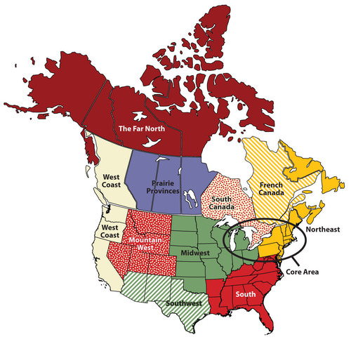
Main regions of the United States and Canada
The Northeastern Core
The Northeastern Core includes the upper Midwest (Illinois, Indiana, Ohio, and Michigan); the mid-Atlantic states of Pennsylvania, New York, Maryland, and New Jersey plus northern Virginia; and the southern New England states of Connecticut, Rhode Island, and Massachusetts. It also includes southern Ontario, Canada’s capital (Ottawa), and its largest city (Toronto). The physical environments of the Northeastern Core are diverse, including the northern Gulf-Atlantic Coastal Plain, the northern Appalachians, and the area surrounding the Great Lakes.
This region, anchored by North America’s largest metropolis, New York, is the economic heart of the United States and Canada and home to more than a third of each country’s population. The megalopolis—the built-up area from Washington, D.C., to Boston—is part of this region. The core region contains the Rust Belt, which was once the main manufacturing region for North America, but suffered decline with the advent of the information age. The core region hosts the headquarters of countless corporations, banks, financial markets (e.g., Wall Street), universities, cultural institutions (e.g., Broadway, world-class museums, dance and music organizations), and even global organizations such as the United Nations.
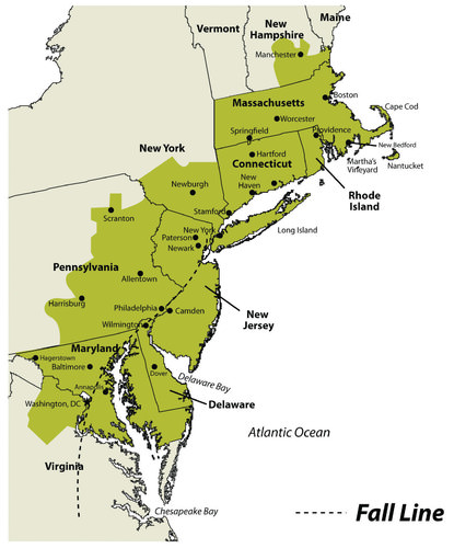
Megalopolis

Downtown Philadelphia’s city hall is an example of the urban qualities of the megalopolis that extends from Boston to Washington, DC.
This large region includes geographic swaths of both wealth and poverty. Eight of the United States’ ten wealthiest counties are in this region, most of them in the Washington, D.C. area. Many billionaires live in New York City as well. Meanwhile, cities such as Detroit and Cleveland have suffered from deindustrialization and have experienced a major population decline since the 1950s. Detroit, for instance, has lost 61 percent of its population since 1950. Moreover, from 2000 to 2010, the city's population decreased by 25 percent.
New England and the Canadian Maritimes
New England and the Canadian Maritimes overlap with the Northeastern Core because its major city—Boston—is considered to be the northern edge of the megalopolis. South of Boston, the low-lying states of New England were the center of colonial settlement in the region and the birthplace of America’s Industrial Revolution. Southern New England began as an agricultural and fishing colony, and as the industry developed in the 19th century, the region attracted European immigrants to work in its factories.
The highly skilled workforce helped maintain a strong economy in southern New England, although there have been times of increased unemployment and economic hardship. Today the region has a more diverse economic base, including recreation, tourism, finance, telecommunications, and healthcare. The mountains of western New England have been attractive for the development of ski resorts. The coasts of New England are popular destinations for summer vacations.
As you move north from Boston, the terrain becomes more rugged and the soil less fertile. There are fewer economic reasons for people to live in northern New England. The states of Vermont, New Hampshire, and Maine have always been less populated than the southern New England states. Maine is the least populated state in this region. About 90 percent of its land is forested, making it the most forested of the United States. The vast Empty Quarter in western Maine consists of five million acres of privately owned forest and no permanent human inhabitants. Maine’s leading economic activity is manufacturing, and the bulk of it is oriented around paper and other wood products.
Northern New England transitions to the even more rugged and remote uplands of the Canadian Maritimes: New Brunswick, Nova Scotia, Prince Edward Island, Newfoundland, and Labrador. The soil quality is quite poor, as glaciers removed most of it during the various ice ages. The region has a harsh climate and is removed from the major population centers of Canada and the eastern United States.
In the Maritime Provinces, fishing and other sea-oriented businesses have historically been strong here. However, in recent decades overfishing of the North Atlantic has caused a decline in the fishing economy. Tourism has been increasing as a source of revenue, especially in places such as Prince Edward Island, in which tourism is the dominant economic activity. Newfoundland, including Labrador, is Canada’s poorest province.
French Canada
West of the Canadian Maritimes lies the province of Quebec, the heart of which is the St. Lawrence River valley, a lowland separating the Appalachian Mountains to the south from the inhospitable Canadian Shield to the north. France was the first European country to colonize the coastal regions of what is now Canada, the St. Lawrence River Valley (most of the land surrounding the Great Lakes), and the Ohio and Mississippi River valleys, south to the Gulf of Mexico. Although Great Britain obtained all the land from France in 1763 following the French and Indian War, enough French inhabitants occupied part of the territory that the region did not automatically become English speaking.
The core of French Canada today is the St. Lawrence Valley from Montreal to the Atlantic coast and west of Montreal to Ottawa and north to the Hudson Bay. These French speakers, the descendants of the early French settlers, created a vibrant French-Canadian culture. About 21 percent of Canadians speak French as their native language, including about 80 percent of Canadians living in the province of Quebec.
Throughout most of its history, the people of Quebec have been rural farmers, making a living on mostly unproductive land in a place with a short growing season. One unique characteristic of the farms in French Canada is their size and shape. Early on, the farms were laid out as long lots, maximizing the number of farms that would have access to the transportation artery—usually a river, but sometimes a road.
Each farm was about 10 times longer than it was wide and had a small access point to the river, some fertile riverfront land, and a woodlot at the rear of the farm. This land-use pattern was common throughout French Canada and can be seen today in the United States in former French colonies such as Tennessee and Louisiana.
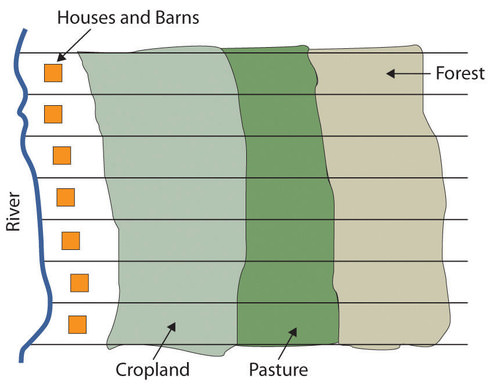
Long lot farms typical in French Canada.
Since then, Quebec’s economy has developed to include a manufacturing sector (fueled by abundant hydroelectricity), tourism, and a variety of tertiary and quaternary industries. Montreal, Canada’s second-largest metropolitan area with over 4 million, is the largest French-speaking city in the Western hemisphere. It developed as the region’s most important city in the mid-19th century, as it controlled access through the St. Lawrence River and the Great Lakes. It became a diverse industrial center, with oil refineries, steel mills, flour and sugar refineries, and shop yards for railroad companies.
Montreal attracted English speakers as well as the local French-speaking people. At times in its history, Montreal has had more English speakers than French speakers, despite being surrounded by a Francophone countryside. Most of northern Quebec is sparsely populated because of the lack of quality soil for agriculture. However, a paper and pulp industry based on its forests as well as the generation of hydroelectric power has developed over the 20th century.
The American South
The South includes the entire southeastern portion of the United States from Kentucky south to Louisiana, east to Florida, and north to Virginia. The South consists of most of the Gulf-Atlantic Coastal Plain and the southern portion of the Appalachian Highlands. Before the Civil War, the coastal plain was dedicated to plantation agriculture using African slave labor.
Land not used for plantation crops such as tobacco, cotton, and rice was typically farmed by poor whites and later by poor blacks. Some were sharecroppers, while others farmed their own small plots, especially on the lesser-quality land in the Appalachia region. The South had little urbanization or industrialization at the time of the Civil War. Well into the 20th century, the region remained rural and economically deprived.
Coal mining was a major source of employment in places such as West Virginia and eastern Kentucky for the first two-thirds of the 20th century. Increased mechanization of mining methods, as well as new mining techniques such as mountaintop removal mining, decreased the number of minors needed, even as coal production increased.
The Appalachian South has high unemployment, poverty, and difficult social conditions. Other areas of the rural South are amongst the poorest in the nation, including the Mississippi Delta and the lower Mississippi River valley. Despite the continued poverty in the South, parts of the region have prospered in the past generation. This is because northern migrants have moved to places such as Atlanta, Charlotte, Tampa, Miami, and many smaller cities in the south. This has fueled a period of urbanization and economic growth, and the newfound prosperity has helped the South move upward in the nation’s economy.

Names often reflect the cultural region of their location. Business names with “Dixie” in them can be found throughout the South. The Dixie Grill restaurant is located in Morehead, Kentucky.
The Midwest and Great Plains
The center of the continent contains a relatively level agricultural region: the Midwest and the Great Plains. This land includes some of the most fertile agricultural land in the entire world. This vast land is known as America’s breadbasket. The climate gets progressively more arid as you move to the west within this region, and the type of agriculture changes with the decrease in precipitation. Closer to the Rocky Mountains, the land is typically used for raising cattle. Grain farms are found where water is available, especially through irrigation.
The water for irrigation comes from the continent’s largest aquifer, the Ogallala Aquifer. Water is often pumped to the surface using a system called center pivot irrigation. The heart of the spring wheat belt is North Dakota, and the crop is also common in eastern Montana and in Canada’s Prairie Provinces of Alberta, Saskatchewan, and Manitoba. Winter wheat is common in Kansas and surrounding states. The corn belt is located farther to the east, mostly in Iowa and Illinois, where rainfall is more abundant.
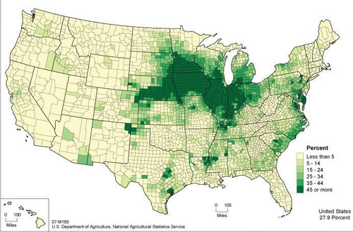
This map shows the extent of the Corn Belt.
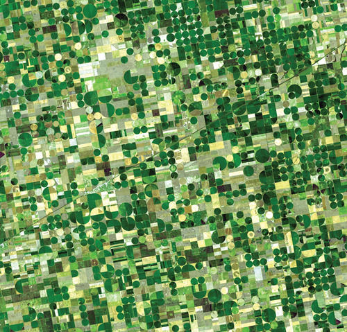
The circular fields are between a half-mile and mile in diameter and are characteristic of fields that use center-pivot irrigation.
The dominant city in this region is Chicago, which developed as a market town for the livestock and grain produced in the surrounding states and was linked to its hinterland through a complex network of rail lines. In fact, nearly all the major cities of this region developed as places for the buying, selling, and processing agricultural products. Today the Midwest and the Great Plains remain the most important food-producing areas in North America, although as agriculture has become increasingly mechanized and farms have gotten larger, the number of farmers has decreased. This region, especially the Great Plains, is experiencing a period of long-term population decline and aging.
The American Southwest
The states of Texas, New Mexico, and Arizona are considered the Southwest. The climate of the Southwest is more arid and receives a high amount of sunlight throughout the year. Desert conditions are integrated with higher elevations in the mountainous areas. Eastern Texas receives more rainfall from the Gulf of Mexico. Western Texas and the states of New Mexico and Arizona are arid and receive less rainfall. These conditions are more favorable to cattle ranching than to other agricultural activities. Large farming operations exist where water is available for irrigation. The warmer climate has been attractive for development and people emigrating from the colder regions of the north.
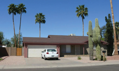
There is no grass to mow, and cactus and palm trees are common.
The Southwest has a strong Hispanic heritage and was part of Spain’s Mexican colony before England established colonies on the East Coast. The first Spanish settlers arrived in New Mexico in 1598. All three states have a large population of Hispanic residents. Some of the families have been in these states before they became part of the United States, and others are recent immigrants. According to the United States Census Bureau, the Hispanic or Latino population in New Mexico is 48.5 percent; in Texas it is 39.1 percent; and, in Arizona, it is 30.9 percent.
The Southwest also has a strong Native American presence, especially in New Mexico and Arizona. Twenty-one federally recognized tribes with more than 250,000 people (4.9 percent of the state’s population) live in Arizona. Their reservations and traditional communities make up more than one-fourth of the state’s land. The Navajo tribe is the largest in the United States, with more than 100,000 members in Arizona alone and others in surrounding states. The considerable Native American and Hispanic population in the Southwest means that non-Hispanic whites make up a minority of the population in New Mexico and Texas.
 One of the Pollen Trail Dancers, a Navajo group near Joseph City, Arizona, performs the Eagle Dance on September 21, 2010, on the scenic South Rim of Grand Canyon National Park between Hopi House and Verkamp’s Visitor Center.
The three Southwestern states have been recipients of Sun Belt migrations over the past few decades, as people have moved to the Southwest for tertiary-sector jobs and for the region's warm climate. The region is urbanized, and most of the new migrants are moving to cities. Three-fourths of Arizona's population lives in the Phoenix or Tucson metropolitan area. The most populous metropolitan area in the Southwest is Dallas-Fort Worth-Arlington, Texas. According to a report released on March 22, 2018, by the US Census Bureau, this area is the fastest growing metro area in the entire United States.
The economy of Texas used to be based on oil and natural gas, but it has since become more diversified. Residents of these cities work in high-tech manufacturing, health care, business, and information. One of the most famous high-tech industries in Texas is space. Houston is home to the National Aeronautics and Space Administration’s (NASA) Lyndon B. Johnson Space Center, where astronauts and thousands of others work in the space industry.
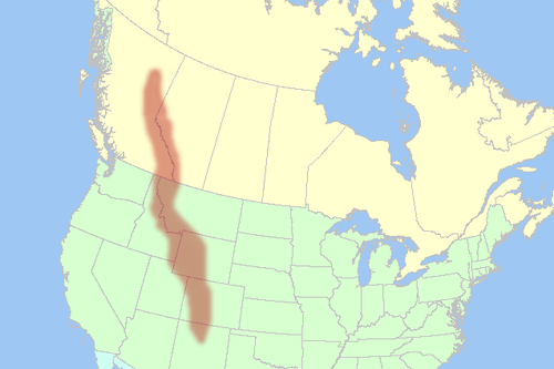
The Mountain West
From the Rocky Mountains to the Sierra Nevada, the Cascades, and Intermontane Basins and Plateaus in between, this part of North America has gone from the old Wild West to an area of rapid economic and population growth. The region encompasses western Colorado, western Wyoming, western Montana, Idaho, Nevada, Utah, the eastern portions of Washington, Oregon, and California, and the southern portion of the Canadian Rockies.
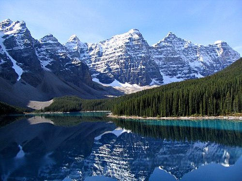
The Rocky Mountains are a major mountain range in western North America.
The Rocky Mountains formed 80 million to 55 million years ago.
The population of the Mountain West is growing much faster than the population of the United States as a whole. For example, Nevada’s population grew 32.3 percent from 2000 to 2009, which is more than three times as much as the United States as a whole (9.1 percent). All US states in this region, except for Montana, grew at faster rates than the US average. Utah grew 24.7 percent, Idaho grew 19.5 percent, and Colorado grew 16.8 percent.
What is fueling this growth? It is part of the larger pattern of Americans flocking to the Sun Belt, searching for a better climate and lifestyle. Jobs have been created in recreation, in high-tech firms, and in other tertiary sector industries. Many of the migrants come from southern California because the housing in the Mountain West is more affordable and the region is much less crowded. Nearly all the growth is occurring in urban and suburban areas.
However, the rapid growth of the West since 1990 has come at a cost. In some areas, the large population is putting a strain on physical resources, such as water. Water is a hot-button political issue, particularly in the more arid states such as Nevada. Las Vegas, for example, is a desert city that gets 90 percent of its water from Lake Mead, a Colorado River reservoir.
This water comes from snowmelt in the Rocky Mountains far to the east, and due to drought and high water demand, Lake Mead’s water level has been dropping. If current patterns persist, Las Vegas will eventually have a water crisis. The water shortage is happening even though Las Vegas has managed to reduce per capita water usage by raising prices for water and creating incentives to remove grass lawns. Las Vegas recycles 94 percent of all sewage water, which is the highest rate in the United States.
As the West’s population increased rapidly, the region’s urban areas became part of the real estate bubble of the early 2000s. Real estate prices grew and the housing industry built one residential subdivision after another in the suburbs surrounding cities such as Las Vegas, Denver, and Salt Lake City. However, in the late 2000s the real estate market collapsed in many parts of the country, and Western cities were hard hit. As of early 2011, three of the five states with the highest foreclosure rates were in this region (Nevada, Utah, and Idaho), and the others were bordering states (Arizona and California).
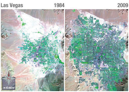
Notice the dark purple of city streets and the bright green of irrigated vegetation.
The Pacific Coast
The Pacific Coast includes the coastal portions of California, Oregon, and Washington, plus the southwestern portion of British Columbia in Canada. This region is typically thought of as two subregions: California and the Pacific Northwest. The two areas are quite different from each other in terms of climate and economy. However, both areas are part of the Ring of Fire that encircles the Pacific Ocean.
The Ring of Fire is a zone of earthquakes and volcanic eruptions that occur near where the Pacific tectonic plate meets the surrounding plates. In the United States, two areas of concern are the San Andreas Fault in California and Mount St. Helens in Washington. The 1906 earthquake that destroyed San Francisco was a result of activity on the San Andreas Fault, and scientists predict that strong earthquakes will reappear along the fault in the future. Thousands of small earthquakes occur along the fault every year. Mount St. Helens is a volcano in the Cascades that erupted in 1980, killing 57 people and destroying hundreds of square miles of forest.
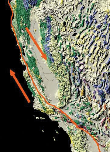
The Pacific tectonic plate is moving northward relative to the North American plate.
The Pacific Coast represents a large population center a continent away from what we consider the North American core. Most of the region's population is urban, and Los Angeles and its metropolitan area is by far the largest area of settlement. Twelve percent of the US population lives in California, and the greater Los Angeles metropolitan area has more than 16 million people. Los Angeles is the second largest US city after New York.
Los Angeles is an automobile city. It developed into a major city in the mid-20th century at the time that automobile ownership had become common. People who lived in the area tended to move to suburbs that were connected to each other by an extensive highway system. Los Angeles is a highly decentralized city, unlike cities in other parts of North America that formed during other transportation regimes.
The Pacific Coast region is also famous for its agriculture. California’s Central Valley lies between the Coast Ranges to the west and the Sierra Nevada to the east. It is one of the most productive agricultural areas in the world. The irrigated farmland in the valley produces all types of non-tropical crops and is the largest US producer of tomatoes, grapes, almonds, and many other foods. When other parts of the country are still frozen in the winter months, the fields of the Central Valley are already producing bountiful harvests. California is also famous for its wine production, especially in Napa Valley near San Francisco.
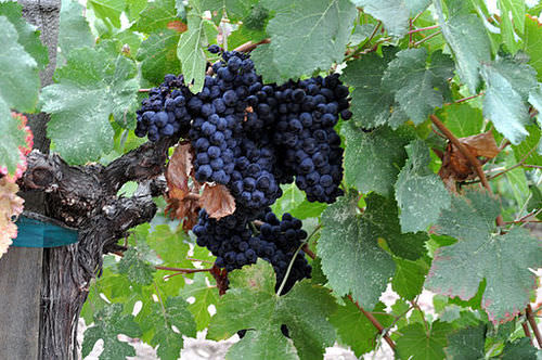
Napa Valley is considered to be one of the premier wine regions in the world.
Besides agriculture, the economic base of the Pacific Coast is diverse and rich. If it were an independent country, California would be the world’s sixth-largest economy. Los Angeles is considered the capital of the US entertainment industry and other major industries including aerospace, manufacturing, and foreign trade. The port of Los Angeles is the busiest in North America, receiving shipments of goods from China and other Asian countries. Silicon Valley, near San Francisco, is a key area for high-tech research and Internet commerce. The Pacific Northwest is home to major corporations such as Boeing, Microsoft, Starbucks, Amazon.com, REI, T-Mobile, Costco, and Eddie Bauer. One of the wealthiest Americans, Bill Gates, lives near Seattle.
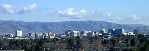
Silicon Valley is a region in the southern San Francisco Bay Area of Northern California.
Across the border to the north, Vancouver is Canada’s third-largest metropolitan area with over two million residents. Vancouver is unlike any other city in North America. Nearly one-third of its residents are of Chinese origin, and more than half its population speak a language other than English at home. Vancouver began as a logging town but developed into its position as the Asian gateway to Canada because of its port, the busiest in Canada. Vancouver is a popular location for the film industry and is sometimes dubbed as “Hollywood North.” It is also growing in the biotechnology and software industries.
The North
The North is the least densely populated of any region in North America due to its brutally cold winters, short growing season, and poor soils. It includes the boreal forests of the upper Great Lakes region and the Canadian Shield and the territory to the north of the tree line that extends beyond the Arctic Circle. Physically, this region is immense, including the state of Alaska and most of Canada. The climate is similar to that of Russia with cold continental and arctic climates, arctic air masses swooping down from the north, and long winters. Most inhabitants of the northern portions of North America live in the forested areas rather than in the frozen Arctic.
Two groups of people live in this region. First, there are the indigenous peoples who have lived in this region for thousands of years. They are small in number and traditionally make a living by hunting and fishing. More recently, the native populations such as the Inuit and the First Nations in Canada subsist by combining wage employment with their traditional means of living off the land. American Indians or Alaskan natives make up about 15 percent of Alaska’s population. In Canada’s Northwest Territories, First Nations people make up just over half of the population, but the total population is small. Nunavut is the northernmost territory in Canada and has a population of approximately 35,000 of which 85 percent are Inuit.
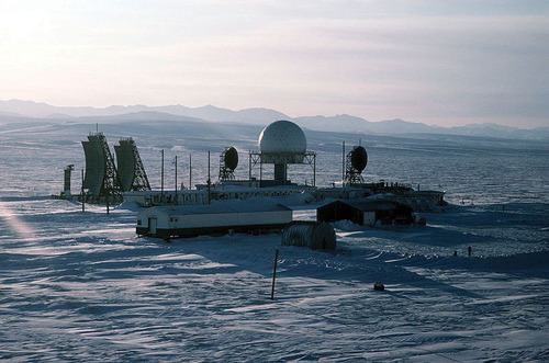
Distant Early Warning (DEW) line station formerly at Point Lay, Alaska.
The other residents are more recent immigrants who are there to profit from the land’s natural resources. The economy is dominated by forestry, oil and natural gas extraction, and mining, which are in the primary economic sector. In the Canadian Shield, metallic ores such as copper, gold, nickel, silver, and uranium are found in the rocks. Moreover, diamond mines are in operation, as are mines producing rare earth elements used in computer screens, electric car batteries, and computer hard drives. These elements include metals such as cerium, terbium, dysprosium, and neodymium. Alaska is an oil-producing state, and the decision of whether to open additional areas of Alaska’s Arctic to oil drilling remains controversial and uncertain.
- The economic core of North America has traditionally been in the US Northeast and its surrounding territory.
- As you move north from Boston into the rest of New England, the Canadian Maritimes, and Quebec, the economy is increasingly based on primary industries such as forestry and fishing.
- Agriculture and mining have been in decline in the South, while tertiary and quaternary industries have attracted new migrants to the region’s urban and suburban areas.
- The Midwest and the Great Plains make up North America’s breadbasket. The climate gets more arid as you move west, but through irrigation, agricultural productivity remains high.
- The Southwest is unique in its high proportion of Hispanic and Native American residents.
- The Mountain West is growing rapidly, especially in its urban and suburban areas. This is putting stress on the physical environment (particularly its water resources) and made the region susceptible to the real estate collapse.
- The Pacific Coast region is prone to earthquakes and volcanic activity, yet it is home to the second-largest metropolitan area in the United States and is known for its rich, diverse economic base.
- The far northern stretches of North America are sparsely populated, with an economy based on primary industries such as forestry and extraction. The North, both Canada and Alaska, is also known for its large native populations.
Vocabulary Terms
| alluvial plain | An area of fertile soil left by river floods |
| Canadian Shield | A northern part of the interior lowlands that is rocky, a flat region covering nearly two million square miles and encircling the Hudson Bay |
| Columbian Exchange | The exchange of animals, plants, and diseases between America, Africa, and Europe following the voyage of Christopher Columbus. Trade from the Old World (Europe) to the New World (North and South America) and back |
| Continental Divide | The line of the highest points in North America that marks the separation between rivers flowing eastward and westward |
| ecumene | A geographic region that is well suited for permanent settlement by people |
| First Nations | A group of Canada's Native American people |
| glaciation | The changing of landforms by slow-moving glaciers |
| Great Plains | A vast grassland of central North America that is largely treeless and ascends to 4,000 feet above sea level. |
| hydroelectric Power | Electricity that is generated from the power of moving water. |
| metis | A person of mixed French-Canadian and Native American ancestry |
| moraine | A mass of dirt and rock that has been left by a glacier as it retreats |
| parliament | A representative lawmaking body whose members are elected or appointed in which legislative and executive functions are combined |
| postindustrial economy | An economic phase in which manufacturing no longer plays a dominant role |
| Rust Belt | Also known as the manufacturing belt, it is located in the northeastern parts of the United States and Midwest states that contain older industries and factories |
| St. Lawrence Seaway | North America's most important deepwater ship route, connecting the Great Lakes to the Atlantic Ocean by way of the St. Lawrence River |
| Sun Belt | A wide area of the United States that has a mild climate all year |
Applying Knowledge
Interactive Notebook Activities
- Name the key characteristics of the regions of the United States and Canada.
- Describe the patterns of population growth or decline for the various regions.
- List which regions have significant minority groups and why.
- Explain the relationship between the environmental and social costs to rapid growth in the West.
- Summarize how physical geography has contributed to economic activities.
Discussion and Study Questions
- Where is the largest US megalopolis located? What region is it part of?
- What is the purpose of long lots? Where would they be most prominent?
- What have been some of the traditional economic activities in the American South? How is this changing?
- Why is there a difference between where spring wheat and winter wheat is grown?
- Name the main ethnic groups that are prominent in the American Southwest.
- Why does the population continue to increase in the American West?
- What makes the Pacific Coast region an unstable place for human development?
- Why does the Pacific Coast region have both high agricultural production and large high-tech urban cities?
- Why does the desert region of the American Southwest continue to attract a growing population?
- What have been the main economic activities in The North?
Real-World Geography Exercise
Using Google Maps, find a large city located in one of the regions below. Calculate the distance and how long it would take to drive from your house to your chosen destination. Be prepared to share your answers.
- Northwestern Core
- New England and the Canadian Maritimes
- French Canada
- The American South
- The Midwest and Great Plains
- The American Southwest
- The Mountain West
- The Pacific Coast
- The North
Mapping Exercise
Life on the Edge: In this activity, students will investigate the Pacific Ocean’s Ring of Fire, with particular focus on earthquake and volcanic activity in East Asia, where millions of people live with the daily threat of significant seismic or volcanic events.
Student Supplemental Materials-download
Videos for Geography Enrichment
Helpful Websites for the Study of Geography
Canadian Encyclopedia is an encyclopedia funded by the Canadian government covering all branches of knowledge. Their scholarly collection includes interactive materials.
CIA World Factbook provides information on the people, history, government, economy, energy, geography, communications, transportation, military, and transnational issues for the world's entities.
Congress.gov is a US government website where you can find federal legislation, past and present, as well as information about the US legal system.
Drug Enforcement Administration (DEA) is a government agency website that provides current news, resources, topics of interest, information about drugs, careers in the DEA, and a tip hotline.
Library of Congress is the largest library in the world and provides manuscripts, files, information, pictures, and videos.
NASA Earth Observatory (NEO) is a US government agency website that allows users to search for and retrieve satellite images of Earth.
National Archives is a US government website that provides historical documents, photos, records, publications, and educator resources.
National Oceanic and Atmospheric Association (NOAA) is a US government agency website that provides weather-related information and ocean research.
National Map is a website by the United States Geological Survey and other federal, state, and local agencies that deliver topographic information for the United States.
NationMaster is a massive central data source and a handy way to graphically compare nations.
Real-Time World Air Quality Index is a website that measures most locations in the world for air pollution in real time.
StateMaster is a unique statistical database, which allows you to research and compare a multitude of different data on US states.
United Nations (UN) is an international organization founded in 1945 and made up of 193 member states. The UN maintains international peace and security, protects human rights, delivers humanitarian aid, promotes sustainable development, and upholds international law.
United States Census Bureau is a US government agency that provides a population clock, data, surveys, statistics, a library with information and infographics, news about the economy, and much more.
United States Geological Survey (USGS) is a US government agency website that provides scientific information about the natural hazards that threaten lives, the natural resources we rely on, the health of our ecosystems and environment, and the impacts of climate and land-use change.
Whitehouse.gov is a US government website that provides the latest presidential news, information about the budget, policy, defense, and many more topics.
World Health Organization (WHO) is under the United Nations and provides leadership on matters critical to health, shapes the research agenda on health, and monitors the health situation and assessing health trends around the world. Their website provides information on the state of health around the world, outbreaks, current health news, and more.
World Trade Organization (WTO) is an intergovernmental organization that regulates international trade. The website provides information on the history of the multilateral trading system, featured videos, news and events, trade topics, and more.
| Image | Reference | Attributions |
|
[Figure 1] | Credit: http://open.lib.umn.edu/worldgeograp...es-and-canada/ Source: open.lib.umn.edu/worldgeography/wp-content/uploads/sites/181/2016/04/c7825eb44409f27a90197f4871e199ff.jpg License: CC BY-NC 3.0 |
|
[Figure 2] | Credit: http://open.lib.umn.edu/worldgeograp...es-and-canada/ Source: open.lib.umn.edu/worldgeography/wp-content/uploads/sites/181/2016/04/94f9224a82ac88c45ae0e19b41dbb8b0.jpg License: CC BY-NC 3.0 |
|
[Figure 3] | Credit: Henk Sijgers – A direct line to city hall – CC BY-NC 2.0. Source: http://open.lib.umn.edu/worldgeography/chapter/4-5-regions-of-the-united-states-and-canada/ License: CC BY-NC 3.0 |
|
[Figure 4] | Credit: http://open.lib.umn.edu/worldgeograp...es-and-canada/ Source: open.lib.umn.edu/worldgeography/wp-content/uploads/sites/181/2016/04/d57713db270fa9f9c503e21b7689840a.jpg License: CC BY-NC 3.0 |
|
[Figure 5] | Credit: Photo by R. Berglee – CC BY-NC-SA. Source: open.lib.umn.edu/worldgeography/wp-content/uploads/sites/181/2016/04/95c7ace10732eda62687a8148bfaca8f.jpg License: CC BY-NC 3.0 |
|
[Figure 6] | Credit: Map courtesy of US Department of Agriculture. Source: open.lib.umn.edu/worldgeography/wp-content/uploads/sites/181/2016/04/ad5ae228c3d809fe87880630f1aa62a4.jpg License: CC BY-NC 3.0 |
|
[Figure 7] | Credit: Photo courtesy of NASA/GSFC/METI/ERSDAC/JAROS and U.S./Japan ASTER Science Team Source: open.lib.umn.edu/worldgeography/wp-content/uploads/sites/181/2016/04/f1e0ed51cccbb61c7542bc941e225051.jpg License: CC BY-NC 3.0 |
|
[Figure 8] | Credit: Photo by R. Berglee – CC BY-NC-SA. Source: open.lib.umn.edu/worldgeography/wp-content/uploads/sites/181/2016/04/9dc0b4802b648927015914dfd280bbce.jpg License: CC BY-NC 3.0 |
|
[Figure 9] | Credit: Grand Canyon National Park – Grand Canyon Eagle Dancer – CC BY 2.0. Source: open.lib.umn.edu/worldgeography/wp-content/uploads/sites/181/2016/04/13db7b5114ee42fdad78b050195606d6.jpg License: CC BY-NC 3.0 |
|
[Figure 10] | Credit: By Gorgo (Photo taken by author) [Public domain], via Wikimedia Commons Source: https://commons.wikimedia.org/wiki/File:Moraine_Lake_17092005.jpg License: CC BY-NC 3.0 |
|
[Figure 11] | Credit: By al guy (talk · contribs) [GFDL (http://www.gnu.org/copyleft/fdl.html) or CC-BY-SA-3.0 (http://creativecommons.org/licenses/by-sa/3.0/)], via Wikimedia Commons Source: https://commons.wikimedia.org/wiki/File:RockyMountainsLocatorMap.png License: CC BY-NC 3.0 |
|
[Figure 12] | Credit: Images courtesy of NASA Source: open.lib.umn.edu/worldgeography/wp-content/uploads/sites/181/2016/04/a226ae82224e27dc4697a48ef3eb8a29.jpg License: CC BY-NC 3.0 |
|
[Figure 13] | Credit: Image courtesy of USGS Source: open.lib.umn.edu/worldgeography/wp-content/uploads/sites/181/2016/04/b27dfb295487dbc06d713defb7533d1c.jpg License: CC BY-NC 3.0 |
|
[Figure 14] | Credit: Photograph by D Ramey Logan [CC BY-SA 3.0 (https://creativecommons.org/licenses/by-sa/3.0)], from Wikimedia Commons Source: commons.wikimedia.org/wiki/File:Napa_Valley_grapes_Photo_D_Ramey_Logan_02.JPG License: CC BY-NC 3.0 |
|
[Figure 15] | Credit: By Photo created and uploaded by SCUMATT (from en.Wikipedia) [CC BY 2.5 (https://creativecommons.org/licenses/by/2.5)], via Wikimedia Commons Source: commons.wikimedia.org/wiki/File:SJPan.jpg License: CC BY-NC 3.0 |
|
[Figure 16] | Credit: Wikimedia Commons – public domain. Source: open.lib.umn.edu/worldgeography/wp-content/uploads/sites/181/2016/04/0d310000cc85c9fedc74201874b54f17.jpg License: CC BY-NC 3.0 |