
3.5: Canada (2 Days)
- Page ID
- 1951
\( \newcommand{\vecs}[1]{\overset { \scriptstyle \rightharpoonup} {\mathbf{#1}} } \)
\( \newcommand{\vecd}[1]{\overset{-\!-\!\rightharpoonup}{\vphantom{a}\smash {#1}}} \)
\( \newcommand{\dsum}{\displaystyle\sum\limits} \)
\( \newcommand{\dint}{\displaystyle\int\limits} \)
\( \newcommand{\dlim}{\displaystyle\lim\limits} \)
\( \newcommand{\id}{\mathrm{id}}\) \( \newcommand{\Span}{\mathrm{span}}\)
( \newcommand{\kernel}{\mathrm{null}\,}\) \( \newcommand{\range}{\mathrm{range}\,}\)
\( \newcommand{\RealPart}{\mathrm{Re}}\) \( \newcommand{\ImaginaryPart}{\mathrm{Im}}\)
\( \newcommand{\Argument}{\mathrm{Arg}}\) \( \newcommand{\norm}[1]{\| #1 \|}\)
\( \newcommand{\inner}[2]{\langle #1, #2 \rangle}\)
\( \newcommand{\Span}{\mathrm{span}}\)
\( \newcommand{\id}{\mathrm{id}}\)
\( \newcommand{\Span}{\mathrm{span}}\)
\( \newcommand{\kernel}{\mathrm{null}\,}\)
\( \newcommand{\range}{\mathrm{range}\,}\)
\( \newcommand{\RealPart}{\mathrm{Re}}\)
\( \newcommand{\ImaginaryPart}{\mathrm{Im}}\)
\( \newcommand{\Argument}{\mathrm{Arg}}\)
\( \newcommand{\norm}[1]{\| #1 \|}\)
\( \newcommand{\inner}[2]{\langle #1, #2 \rangle}\)
\( \newcommand{\Span}{\mathrm{span}}\) \( \newcommand{\AA}{\unicode[.8,0]{x212B}}\)
\( \newcommand{\vectorA}[1]{\vec{#1}} % arrow\)
\( \newcommand{\vectorAt}[1]{\vec{\text{#1}}} % arrow\)
\( \newcommand{\vectorB}[1]{\overset { \scriptstyle \rightharpoonup} {\mathbf{#1}} } \)
\( \newcommand{\vectorC}[1]{\textbf{#1}} \)
\( \newcommand{\vectorD}[1]{\overrightarrow{#1}} \)
\( \newcommand{\vectorDt}[1]{\overrightarrow{\text{#1}}} \)
\( \newcommand{\vectE}[1]{\overset{-\!-\!\rightharpoonup}{\vphantom{a}\smash{\mathbf {#1}}}} \)
\( \newcommand{\vecs}[1]{\overset { \scriptstyle \rightharpoonup} {\mathbf{#1}} } \)
\(\newcommand{\longvect}{\overrightarrow}\)
\( \newcommand{\vecd}[1]{\overset{-\!-\!\rightharpoonup}{\vphantom{a}\smash {#1}}} \)
\(\newcommand{\avec}{\mathbf a}\) \(\newcommand{\bvec}{\mathbf b}\) \(\newcommand{\cvec}{\mathbf c}\) \(\newcommand{\dvec}{\mathbf d}\) \(\newcommand{\dtil}{\widetilde{\mathbf d}}\) \(\newcommand{\evec}{\mathbf e}\) \(\newcommand{\fvec}{\mathbf f}\) \(\newcommand{\nvec}{\mathbf n}\) \(\newcommand{\pvec}{\mathbf p}\) \(\newcommand{\qvec}{\mathbf q}\) \(\newcommand{\svec}{\mathbf s}\) \(\newcommand{\tvec}{\mathbf t}\) \(\newcommand{\uvec}{\mathbf u}\) \(\newcommand{\vvec}{\mathbf v}\) \(\newcommand{\wvec}{\mathbf w}\) \(\newcommand{\xvec}{\mathbf x}\) \(\newcommand{\yvec}{\mathbf y}\) \(\newcommand{\zvec}{\mathbf z}\) \(\newcommand{\rvec}{\mathbf r}\) \(\newcommand{\mvec}{\mathbf m}\) \(\newcommand{\zerovec}{\mathbf 0}\) \(\newcommand{\onevec}{\mathbf 1}\) \(\newcommand{\real}{\mathbb R}\) \(\newcommand{\twovec}[2]{\left[\begin{array}{r}#1 \\ #2 \end{array}\right]}\) \(\newcommand{\ctwovec}[2]{\left[\begin{array}{c}#1 \\ #2 \end{array}\right]}\) \(\newcommand{\threevec}[3]{\left[\begin{array}{r}#1 \\ #2 \\ #3 \end{array}\right]}\) \(\newcommand{\cthreevec}[3]{\left[\begin{array}{c}#1 \\ #2 \\ #3 \end{array}\right]}\) \(\newcommand{\fourvec}[4]{\left[\begin{array}{r}#1 \\ #2 \\ #3 \\ #4 \end{array}\right]}\) \(\newcommand{\cfourvec}[4]{\left[\begin{array}{c}#1 \\ #2 \\ #3 \\ #4 \end{array}\right]}\) \(\newcommand{\fivevec}[5]{\left[\begin{array}{r}#1 \\ #2 \\ #3 \\ #4 \\ #5 \\ \end{array}\right]}\) \(\newcommand{\cfivevec}[5]{\left[\begin{array}{c}#1 \\ #2 \\ #3 \\ #4 \\ #5 \\ \end{array}\right]}\) \(\newcommand{\mattwo}[4]{\left[\begin{array}{rr}#1 \amp #2 \\ #3 \amp #4 \\ \end{array}\right]}\) \(\newcommand{\laspan}[1]{\text{Span}\{#1\}}\) \(\newcommand{\bcal}{\cal B}\) \(\newcommand{\ccal}{\cal C}\) \(\newcommand{\scal}{\cal S}\) \(\newcommand{\wcal}{\cal W}\) \(\newcommand{\ecal}{\cal E}\) \(\newcommand{\coords}[2]{\left\{#1\right\}_{#2}}\) \(\newcommand{\gray}[1]{\color{gray}{#1}}\) \(\newcommand{\lgray}[1]{\color{lightgray}{#1}}\) \(\newcommand{\rank}{\operatorname{rank}}\) \(\newcommand{\row}{\text{Row}}\) \(\newcommand{\col}{\text{Col}}\) \(\renewcommand{\row}{\text{Row}}\) \(\newcommand{\nul}{\text{Nul}}\) \(\newcommand{\var}{\text{Var}}\) \(\newcommand{\corr}{\text{corr}}\) \(\newcommand{\len}[1]{\left|#1\right|}\) \(\newcommand{\bbar}{\overline{\bvec}}\) \(\newcommand{\bhat}{\widehat{\bvec}}\) \(\newcommand{\bperp}{\bvec^\perp}\) \(\newcommand{\xhat}{\widehat{\xvec}}\) \(\newcommand{\vhat}{\widehat{\vvec}}\) \(\newcommand{\uhat}{\widehat{\uvec}}\) \(\newcommand{\what}{\widehat{\wvec}}\) \(\newcommand{\Sighat}{\widehat{\Sigma}}\) \(\newcommand{\lt}{<}\) \(\newcommand{\gt}{>}\) \(\newcommand{\amp}{&}\) \(\definecolor{fillinmathshade}{gray}{0.9}\)- Identify where in the country most Canadians live and why.
- Identify and locate the dominant physical features of Canada.
- Distinguish between the French-speaking and English-speaking areas of Canada and discuss the key activities in the effort to promote French culture in Canada.
- Name the characteristics of some of the minority ethnic groups in Canada.
- Determine which economic sectors are at the core of the Canadian economy and how the Canadian and US economies are connected.
TEKS Regional Unit 03 United States and Canada: Chapter 3.5 Canada
WG.1A Analyze significant physical features and environmental conditions that have influenced the past and migration patterns and have shaped the distribution of culture groups today.
WG.1B Trace the spatial diffusion of phenomena such as the Columbian Exchange or the diffusion of American popular culture and describe the effects on regions of contact
WG.2A Describe the human and physical characteristics of the same regions at different periods of time to analyze relationships between past events and current conditions
WG.3A Explain the weather conditions and climate in relation to annual changes in Earth-Sun relationships
WG.4A Explain how elevation, latitude, wind systems, ocean currents, position on a continent, and mountain barriers influence temperature, precipitation, and distribution of climate regions
WG.4B Describe different land forms such as plains, mountains, and islands and the physical processes that cause their development
WG.4C Explain the influence of climate on the distribution of biomes in different regions
WG.5A Analyze how the character of a place is related to its political, economic, social, and cultural elements
WG.6B Explain the processes that have caused changes in settlement patterns, including urbanization, transportation, access to and availability of resources, and economic activities
WG.8A Compare ways that humans depend on, adapt to, and modify the physical environment, including the influences of culture and technology
WG.9A Identify physical and/or human factors such as climate, vegetation, language, trade networks, political units, river systems, and religion that constitute a region
WG.10D Compare global trade patterns over time and analyze the implications of globalization, including outsourcing and free trade zones
WG.11C Assess how changes in climate, resources, and infrastructure (technology, transportation, and communication) affect the location and patterns of economic activities.
WG.16C Describe life in a variety of urban and rural areas in the world to compare political, economic, social, and environmental changes.
WG.21C Create and interpret types of maps to answer geographic questions, infer relationships, and analyze change.
WG.22A Create appropriate graphics such as maps, diagrams, tables, and graphs to communicate geographic features, distributions, and relationships. features, distributions, and relationships
WG.22B Generate summaries, generalizations, and thesis statements supported by evidence
Canada
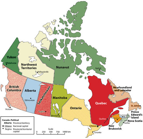
Canadian Provinces and Territories
Canada’s democratic state shares a similar developmental history and economic status with the United States. As of 2011, Canada had a population of just over 34 million, which is less than the population of California. Canada is larger than the United States, making it the second largest country in the world. However, despite this vast territory for a relatively small population, more than 90 percent of Canadians live within 150 miles of the US border.
Northern Canada is not considered part of Canada’s habitable zone for permanent human settlement. Only a narrow band of territory in southern and eastern Canada has the climate and physical geography suitable for agricultural production and widespread settlement. Moreover, Canada’s economy is so closely tied to that of the United States that it makes sense for people to live close to the US border.
Physical Geography of Canada
Ontario has by far the largest population of any of Canada’s provinces, with about 39 percent of the total. Quebec, the dominantly French-speaking province, is home to about 23 percent. Almost everyone else lives in British Colombia, west of the Rocky Mountains (13 percent); in the prairies (18 percent); or along the Atlantic coast (7 percent). The wide-open areas of Canada’s far north are occupied by only one-third of one percent of the population.
The continental Type D climate dominates most of central Canada, with its characteristically warm summers and cold winters. However, summers are cooler as you move farther north. Canada’s west coast receives the most precipitation—between 80 and 100 inches per year. The coastal areas in the Maritime Provinces can receive up to 60 inches per year. The northern territory of Nunavut barely receives 10 inches per year, usually in the form of snow.
The far northern region of Canada has an arctic type E climate. The conditions there are so harsh that only a very few people inhabit it. The cultural influence of the colder climates and the long winters on the people is evident by the sports that are enjoyed by most Canadian citizens. Ice hockey is Canada’s most popular sport and its most popular spectator sport. Other sports such as curling are also common in Canada.

The Canadian and Finnish junior teams face off during a junior ice hockey exhibition game in Calgary, Alberta.
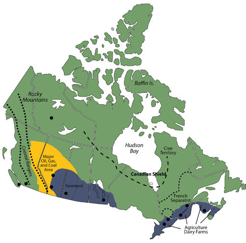
Canada has abundant natural resources for its population. The Canadian Shield is an area of rock and forest that covers much of central Canada around the Hudson Bay. This region, and the area to the east and west of it provides timber and minerals for Canadian industries and for export. In the Maritime Provinces of the east, the main economic activities include fishing and agriculture.
Some of Canada’s best farmland is located along the St. Lawrence River and in the southern Prairie Provinces of Manitoba, Saskatchewan, and Alberta. The St. Lawrence River region includes dairy farms and agriculture, which provide food for the larger cities of the region. The province of Ontario has fertile farmland on the north and east sides of the Great Lakes. The farmland in the Prairie Provinces has much larger grain and beef operations.
Centered in the province of Alberta is a large region of fossil fuel exploration. Coal, oil, and natural gas are found there in abundance, and much of it is exported to the United States for profit. Oil is found absorbed in surface soil called tar sands and is being extracted for energy. When tar sands are heated, the oil is separated and refined for fuel. Projections are that there is more oil in the tar sands of Canada than in the underground reserves of Saudi Arabia. Natural resources have even filtered into the cultural arena: Edmonton’s professional hockey team is called the Edmonton Oilers.
Map of the physical features of Canada.
The Rocky Mountains and the coastal ranges located in western Canada provide for mining and lumber mills. Vancouver, on the coast in British Columbia, has become a major port for Canada to export and import goods to and from the Pacific Rim. The Yukon Territory, also located in the mountains, has experienced a gold rush in years past. Canada has adequate natural resources to provide for its people and gain wealth.
Comparing British and French Canada
French fishermen and fur traders initially colonized Canada. The British later took it from the French, and immigrants from various other countries moved there to make a living off of the land. Although none of the provinces retain French names, countless cities have French names. Some of these cities include Montreal, Lacombe, Leduc, Trois-Rivières, Charlesbourg, and Beauport.
The names of several provinces have a British etymology. Nova Scotia means “New Scotland,” and it was so named by the British when they took over the island from the French. Prince Edward Island was named for the father of the famous 19th-century British queen, Victoria. You can see remnants of British colonialism in the way the Canadian government is organized. Canada, like many countries of Europe, including Great Britain, is a parliamentary democracy.
The monarch of the United Kingdom is still the top-ranking government official in Canada, but only as a figurehead. The queen (or king) appoints a governor general to be her (or his) representative in the Canadian federal government. Again, this is a symbolic position. There are two chambers, a House of Commons and a Senate. Members of the House of Commons are elected and are called members of Parliament. Senators are appointed to a lifelong term by the prime minister.
As of 2006, about 58 percent of Canadians spoke English as their primary language, French was the language of 22 percent, and 20 percent spoke a language other than English or French. [1] For most of Canada, the lingua franca remains English. The French-speaking portion of Canada is a reminder of Canada’s history as a French colony. Many of today’s French speakers are descendants of those earlier French settlers.
The proportion of French speakers in Canada is declining as more immigrants, who also have higher fertility rates than French speaking citizens, arrive from other parts of the world. In addition, more French speakers are using English instead of French as their primary language. These immigrants to Canada, along with indigenous people, make up 20 percent of Canada’s population who do not speak English or French as their native language. About 90 percent of Canadian people who speak French live in Quebec, which is a center of French culture in Canada.
The separation between French Canada and British Canada goes back to colonial times. Beginning in the 1530s, the French were the first to begin fur trading in the region and colonize what is present-day Canada, calling it New France. The French claimed much of the St. Lawrence River valley and the Great Lakes region, including the region that is now Ontario. When Britain began to dominate the eastern coast of North America in the 1680s, they entered into a series of wars with France. As a result of these wars, New France was eventually turned over to Britain.
Not wanting continued war with France, Britain allowed the French-dominated region to retain its land ownership system, civil laws, and Catholic faith. The American Revolution, which granted the United States independence from Great Britain, also pushed many people of English descent (especially those who sided with Britain), from the United States into Canada. British North America no longer included the United States. Canada became the main British colony in North America.
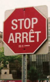
Bilingual Stop Sign in Ottawa, Ontario.
In an attempt to keep the peace between French and English settlers, in 1791 the British Parliament divided Quebec into Upper and Lower Canada, which later evolved into the provinces of English-speaking Ontario and French-speaking Quebec. The Maritime Provinces of the east were then separated into individual provinces.
The cultural differences between French-speaking Canada and the rest of Canada have erupted into serious political conflicts. The French-speaking areas, mainly southern Quebec, argue that they are treated unfairly since they have to learn English when the rest of the country is not required to learn French.
During the second half of the 20th century, many people in Quebec supported a separatist movement that sought to break Quebec off from the rest of Canada into an independent country. In the 1980s, the separatist initiative lost in a public vote by a small margin. The issue of Quebec’s sovereignty continued to be raised in the public arena. In 1998, Canada’s Supreme Court ruled that Quebec could not separate from the rest of Canada under international law. However, the matter would have to be negotiated between Quebec and the rest of Canada if secession was to proceed.
French and English are the two official languages of the Canadian government as a whole. However, the French people in Quebec, fearing that English was dominating the media, the Internet, and industry to such an extent that it was endangering their French culture, have declared French as the only official language of the province. To combat the encroachment of English, laws were enacted in Quebec requiring all public advertising to be in French, or if other languages are used, they must be half the size of the French letters. All businesses employing more than 50 employees are required to conduct all business in French.
Immigrants who wish to be citizens of Quebec must learn French. All primary and secondary education takes place in French unless the child’s parents were educated in English elsewhere in Canada. Civil servants dubbed the “language police” monitor and enforce the French language laws. A business found to be out of compliance with the language laws could be fined or shut down. Even though the official language of Quebec is French, since the national government takes place in both English and French, some services are still available in Quebec in English.
French Canada does not include the entire province of Quebec. Northern Quebec has traditionally been native Cree territory. When the initiative for Quebec to secede from Canada was being considered, an additional initiative was presented by the Cree to separate northern Quebec from the French region of Quebec. This would have caused the French separatist region of Quebec to lose major hydroelectric dams and important mineral and timber reserves. Other regions of Quebec that did not hold a French majority would then have promoted separating from Quebec and joining Ontario.
For Quebec to remain economically competitive, they would need the northern Cree region to remain part of the province to use the resources and energy found there. They would also need the businesses currently in Quebec to stay there. However, many would have left if Quebec had become an independent state with French as the only language. When secession was being considered, it was found that many businesses employing more than 50 employees did not want to switch over and conduct all their business in French. They were conducting their business in English to work with the global economic community.
In 1994, the North American Free Trade Agreement (NAFTA) was established between Canada, the United States, and Mexico. The goal was to open up new lines of business operations amongst the three countries and to increase economic opportunities to better compete with the European Union and the Pacific Rim nations. What would Quebec do if it separated from Canada? Would Quebec be able to join NAFTA? What if the other NAFTA partners cut off Quebec? Quebec would have faced serious economic consequences if they had separated from Canada. A number of English-speaking businesses have already moved to Ontario, Canada’s most populous province, to avoid changing to French. It appears Quebec will remain with the rest of Canada for the time being.
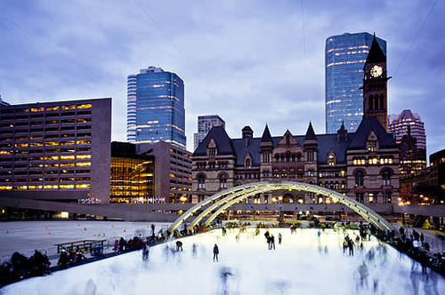
Nathan Phillips Square is Toronto's main square.
Other Ethnic Groups in Canada
When the Europeans arrived in Canada, the indigenous people were displaced. About 1.2 million people who identify themselves as Aboriginal live in Canada (about 3.8 percent of the total population). They include North American Indians (also called First Nations), Métis (descendants of both Europeans and American Indians), and Inuit (inhabitants of the far Arctic north). Of these three groups, Inuit have the smallest population, with only about 50,000 remaining. These native people represent more than 600 recognized groups and 65 language dialects. Only a handful of these languages are still spoken by enough people to remain viable languages.
Countless place names in Canada have native language etymologies. For example, the city of Quebec is built at the original head of navigation on the St. Lawrence River. Its name comes from an Algonquin word for “where the river narrows.” The word Canada is likely derived from the St. Lawrence Iroquois word Kanata, meaning “village” or “settlement.” While the French explorer Jacques Cartier was traveling up the St. Lawrence River in 1535, the indigenous peoples directed him to a specific village, the future Quebec City, using the word Kanata. He later used Canada to refer to the general area, and European mapmakers adopted it for the entire region.
Quebec is not the only place where devolutionary forces have been dividing cultural groups in Canada. In 1999, Nunavut officially broke from the Northwest Territory to become its own territory. Nunavut has only about 30,000 people in an area larger than any other province or territory in Canada. It comprises about one-fifth of Canada’s land area. Most of the people who had claimed the land before the Europeans arrived are Inuit. Iqaluit, the capital city of Nunavut, is on Baffin Island near Canada’s east coast.
Canada has a great deal of ethnic diversity. One measure of this is the number of languages spoken there. One source estimates that there are about 145 languages spoken in Canada, including English and French. This reflects both the rich native heritage and the history of immigration from around the world. As of 2006, the foreign-born population was 6.2 million, or nearly 20 percent of Canada’s population.
There are few countries that match this level of immigration. Even the United States had only about a 12.5 percent foreign-born population in 2006. If Canada’s current immigration rates continue, by 2017 more than 22 percent of Canada’s population will be foreign born, which equals the high rate seen in the early 20th century, during the golden age of Eastern European immigration to North America. During this period, people from all the countries of Eastern Europe immigrated to all parts of Canada. [2]
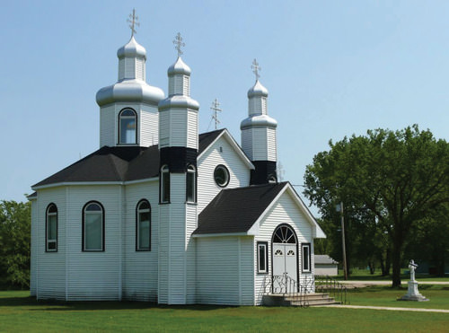
This Ukrainian Greek Orthodox Church is located in the southern region of the Prairie Province of Manitoba.
The current surge of immigrants to Canada does not include many Europeans. Instead, these immigrants come from Asian countries, especially China and countries in South Asia such as India and Pakistan. If immigration patterns stay the same, by 2017 about one in five people in Canada will belong to a nonwhite minority group. According to the 2010 Canadian census, more than one million Chinese and more than one-half of a million South Asians lived in Canada. Other groups increasing rapidly include people from the Middle East and Korea.
The Canadian Economy
Not surprisingly, Canada and the Unites States are each others’ largest trading partners. More than 80 percent of Canadian exports go to the United States and 70 percent of imports to Canada come from the United States. Except for some natural resource industries, most businesses are centered in Canadian cities to take advantage of the available labor force. Canada is rapidly moving toward a knowledge-based economy built on innovation and technology. Industries such as biotechnology and information technology are on the rise, and these are typically located in cities to facilitate partnering with universities and other researchers.
Although Canada is developing into a knowledge-based economy, the foundations of the Canadian economy have always been its abundant natural resources. Canada’s primary industries have traditionally been agriculture, fishing, mining, energy, and forestry. Success in tapping these natural resources for their economic benefit allowed the country to double in population since 1960 while the economy has increased sevenfold.
The primary industries now make up less than 10 percent of the gross domestic product (GDP). Just as in the United States, the most dramatic structural change in the economy has been the rise of the service sector, which now employs about three-quarters of all Canadians and generates over 60 percent of the GDP. Canadian manufacturing has been a strong sector of the economy with close ties to the United States and multinational corporations.
Canada’s economy is tightly tied to that of the United States. One of the best examples is how the Canadian economy fluctuates depending on whether the Canadian dollar is weak or strong compared with the US dollar. For example, in 2002, one American dollar was worth about $1.60 in Canada.
For many years, the American dollar was much stronger on the world market than the Canadian dollar. Therefore, Canadian goods and labor were less expensive for Americans than comparable US labor and goods.
During the time of the weak Canadian dollar, many film and television industries moved to Canada to film television shows and movies because it was less expensive to do so in Canada. Many popular television shows and movies have been filmed in Canada, especially in Toronto and Vancouver.
More recently, the value of the American dollar declined against other major currencies. The Canadian dollar remained strong, which meant that goods produced in Canada became much less affordable in the United States. This resulted in the television and film industries to move back south of the border and Canadian exports to the United States to decline.
In 2007, the Canadian dollar and the US dollar became equal for the first time in 30 years. The two currencies continue to fluctuate with market values.
NAFTA was one of the most significant economic events in North American history. For Canada, the agreement has meant more secure, stable access to US and Mexican markets. The agreement eliminated many tariffs; opened previously protected sectors in agriculture, energy, textiles, and automotive trade; and set specific rules for trade in services such as finance, transportation, and telecommunications. Perhaps most importantly for Canada, the agreement set rules for settling trade disputes.

The CRJ jet aircraft series is manufactured in Canada.
The United States exerts a powerful influence on Canada in a variety of ways. Because of the geographical proximity of the two countries and the mostly shared language of English and cultural values, American trends tend to be adopted by Canadians. Nonetheless, Canadians differentiate themselves from Americans on legale issues, laws, and health care. For example, Canada has a governmet funded health care system that provides free services to its citizens. Canadians often point to this difference as one of the defining elements of their country.
Canada is a great consumer of American popular culture. Canadians listen to, watch, and read tremendous quantities of American music, television and movies, news, books, and other literature. Some Canadians believe that Canadian culture is in danger of being extinguished. In response to these concerns, a law was passed and a watchdog agency created so that a certain percentage of all radio and television programs being broadcasted from Canadian radio and television stations had to originate in Canada or have significant Canadian content.
Others were less worried about the impact of American pop culture on Canadian culture. This segment of the Canadian population felt that Canadians have long identified themselves in contrast to Americans. Therefore, consuming American books, newspapers, television shows, and movies would only give Canadians a better foundation of comparison, thus strengthening the Canadian identity and perception of Canadian culture.
- Canada is a large country with rich natural resources, but a relatively small population that mostly lives in a narrow band in the southern part of the country.
- Canada’s English and French bilingualism is part of its British and French colonial past.
- The French culture is dominant in Quebec, where the population has considered seceding from Canada and becoming an independent country.
- Canada’s native population makes up less than 4 percent of the country’s population but represents a great deal of cultural and linguistic diversity.
- More than one in five Canadians is an immigrant, and most of the recent immigrants come from non-Western countries, especially those in Asia.
Vocabulary Terms
| bilingual | Able to speak two languages with the facility of a native speaker |
| glacier | A large mass of ice found near the Earth's poles or in high, cold mountain valleys |
| igloo | A type of shelter built of snow, typically built when the snow can be easily compacted |
| Inuit | A member of the indigenous people of northern Canada and parts of Greenland and Alaska |
| minister | In the Canadian government, a member of the cabinet, or government executive, usually responsible for a government department |
| parliament | A representative lawmaking body whose members are elected or appointed and in which legislative and executive functions are combined |
| prime minister | Chief political official in the parliamentary system--ex: Canada |
| province | A political region in Canada, much like an American state |
Applying Knowledge
Interactive Notebook Activities
- Identify where in the country most Canadians live and why.
- Identify the dominant physical features of Canada.
- Describe the relationship between the French-speaking and English-speaking areas of Canada.
- Explain the key activities used in an effort to promote French culture in Canada.
- Name the characteristics of some of the minority ethnic groups in Canada.
- Describe which economic sectors are at the core of the Canadian economy.
- Describe how the Canadian and US economies are connected.
Discussion and Study Guide Questions
- Where do most of the people live in Canada? Why do they live where they do?
- What is Canada’s capital city? What is Canada’s largest city?
- What is the difference in farming operations between the two main agricultural areas in Canada?
- Where are large deposits of fossil fuels found in Canada? What are tar sands?
- Where is the highest precipitation found in Canada? Where is the least amount of precipitation found in Canada? Explain this precipitation pattern.
- Who were Canada’s main colonizers? How does the history of colonialism impact Canada today?
- Where have devolutionary forces been active but not totally successful? Where have devolutionary activities already taken place in Canada?
- What problems might Quebec experience if it were to secede from the rest of Canada?
- Where is Nunavut? Why is it a separate territory? Why do you think its capital city in located on the eastern coast of the territory?
- How are current Canadian immigrants impacting the cultural and ethnic makeup of the country?
Real-World Geography Exercises
- Using Google Maps, locate each place on the bulleted list below.
- Using NASA Latitude and Longitude Finder, determine the latitude and longitude for each location on the bulleted list below.
- Be prepared to share and discuss your answers.
Provinces and Territories
- Alberta
- British Columbia
- Manitoba
- New Brunswick
- Newfoundland
- Northwest Territories
- Nova Scotia
- Nunavut
- Ontario
- Prince Edward Island
- Quebec
- Saskatchewan
- Yukon Territory
Cities
- Calgary
- Charlottetown
- Edmonton
- Fredericton
- Halifax
- Iqaluit
- Montreal
- Ottawa
- Quebec City
- Regina
- Johns
- Toronto
- Vancouver
- Victoria
- Whitehorse
- Winnipeg
- Yellowknife
Locations and Features
- Arctic Ocean
- Baffin Island
- Canadian Shield
- Coastal Ranges
- Elsmere Island
- Hudson Bay
- Labrador
- Rocky Mountains
- Lawrence River
Mapping Exercise
Running Hot and Cold: In this activity students will analyze monthly and annual temperature patterns in cities around the world. Students will explore how latitude, elevation, and proximity to the ocean influence temperature patterns in the world’s tropical, temperate, and polar zones.
Videos for Geography Enrichment
Helpful Websites for the Study of Geography
Canadian Encyclopedia is an encyclopedia funded by the Canadian government covering all branches of knowledge. Their scholarly collection includes interactive materials.
CIA World Factbook provides information on the people, history, government, economy, energy, geography, communications, transportation, military, and transnational issues for the world's entities.
Congress.gov is a US government website where you can find federal legislation, past and present, as well as information about the US legal system.
Drug Enforcement Administration (DEA) is a government agency website that provides current news, resources, topics of interest, information about drugs, careers in the DEA, and a tip hotline.
Library of Congress is the largest library in the world and provides manuscripts, files, information, pictures, and videos.
NASA Earth Observatory (NEO) is a US government agency website that allows users to search for and retrieve satellite images of Earth.
National Archives is a US government website that provides historical documents, photos, records, publications, and educator resources.
National Oceanic and Atmospheric Association (NOAA) is a US government agency website that provides weather-related information and ocean research.
National Map is a website by the United States Geological Survey and other federal, state, and local agencies that deliver topographic information for the United States.
NationMaster is a massive central data source and a handy way to graphically compare nations.
Real-Time World Air Quality Index is a website that measures most locations in the world for air pollution in real time.
StateMaster is a unique statistical database, which allows you to research and compare a multitude of different data on US states.
United Nations (UN) is an international organization founded in 1945 and made up of 193 member states. The UN maintains international peace and security, protects human rights, delivers humanitarian aid, promotes sustainable development, and upholds international law.
United States Census Bureau is a US government agency that provides a population clock, data, surveys, statistics, a library with information and infographics, news about the economy, and much more.
United States Geological Survey (USGS) is a US government agency website that provides scientific information about the natural hazards that threaten lives, the natural resources we rely on, the health of our ecosystems and environment, and the impacts of climate and land-use change.
Whitehouse.gov is a US government website that provides the latest presidential news, information about the budget, policy, defense, and many more topics.
World Health Organization (WHO) is under the United Nations and provides leadership on matters critical to health, shapes the research agenda on health, and monitors the health situation and assessing health trends around the world. Their website provides information on the state of health around the world, outbreaks, current health news, and more.
World Trade Organization (WTO) is an intergovernmental organization that regulates international trade. The website provides information on the history of the multilateral trading system, featured videos, news and events, trade topics, and more.
References
[1] Population by Mother Tongue, by Province and Territory (2006 Census)
| Image | Reference | Attributions |
|
[Figure 1] | Credit: Wikimedia Commons – public domain. Source: open.lib.umn.edu/worldgeography/wp-content/uploads/sites/181/2016/04/8b3ca0078caa7ee3525ecba0503d9783.jpg License: CC BY-NC 3.0 |
|
[Figure 2] | Credit: Resolute [CC BY-SA 3.0 (https://creativecommons.org/licenses/by-sa/3.0)], from Wikimedia Commons Source: https://commons.wikimedia.org/wiki/File:Canada_v_Finland_junior_exhibition.png License: CC BY-NC 3.0 |
|
[Figure 3] | Credit: Wikimedia Commons – CC BY 3.0. Source: open.lib.umn.edu/worldgeography/wp-content/uploads/sites/181/2016/04/8bb1f812f2273f80af1b5a17f37f5597.jpg License: CC BY-NC 3.0 |
|
[Figure 4] | Credit: Wikimedia Commons – public domain. Source: open.lib.umn.edu/worldgeography/wp-content/uploads/sites/181/2016/04/c019e2e62e5d408405081e35235c515d.jpg License: CC BY-NC 3.0 |
|
[Figure 5] | Credit: By Benson Kua from Toronto, Canada (Skaters at DuskUploaded by Skeezix1000) [CC BY-SA 2.0 (https://creativecommons.org/licenses/by-sa/2.0)], via Wikimedia Commons Source: commons.wikimedia.org/wiki/File:Skaters_at_dusk.jpg License: CC BY-NC 3.0 |
|
[Figure 6] | Credit: Photo by R. Berglee – CC BY-NC-SA. Source: open.lib.umn.edu/worldgeography/wp-content/uploads/sites/181/2016/04/2daf21f6a96e3d891368379d2e072c03.jpg License: CC BY-NC 3.0 |
|
[Figure 7] | Credit: Wikimedia Commons – public domain. Source: open.lib.umn.edu/worldgeography/wp-content/uploads/sites/181/2016/04/1d20c629ef893af755caf33f61b0d298.jpg License: CC BY-NC 3.0 |