8.1: Africa- Introducing the Realm (1 Day)
- Page ID
- 1962
\( \newcommand{\vecs}[1]{\overset { \scriptstyle \rightharpoonup} {\mathbf{#1}} } \)
\( \newcommand{\vecd}[1]{\overset{-\!-\!\rightharpoonup}{\vphantom{a}\smash {#1}}} \)
\( \newcommand{\dsum}{\displaystyle\sum\limits} \)
\( \newcommand{\dint}{\displaystyle\int\limits} \)
\( \newcommand{\dlim}{\displaystyle\lim\limits} \)
\( \newcommand{\id}{\mathrm{id}}\) \( \newcommand{\Span}{\mathrm{span}}\)
( \newcommand{\kernel}{\mathrm{null}\,}\) \( \newcommand{\range}{\mathrm{range}\,}\)
\( \newcommand{\RealPart}{\mathrm{Re}}\) \( \newcommand{\ImaginaryPart}{\mathrm{Im}}\)
\( \newcommand{\Argument}{\mathrm{Arg}}\) \( \newcommand{\norm}[1]{\| #1 \|}\)
\( \newcommand{\inner}[2]{\langle #1, #2 \rangle}\)
\( \newcommand{\Span}{\mathrm{span}}\)
\( \newcommand{\id}{\mathrm{id}}\)
\( \newcommand{\Span}{\mathrm{span}}\)
\( \newcommand{\kernel}{\mathrm{null}\,}\)
\( \newcommand{\range}{\mathrm{range}\,}\)
\( \newcommand{\RealPart}{\mathrm{Re}}\)
\( \newcommand{\ImaginaryPart}{\mathrm{Im}}\)
\( \newcommand{\Argument}{\mathrm{Arg}}\)
\( \newcommand{\norm}[1]{\| #1 \|}\)
\( \newcommand{\inner}[2]{\langle #1, #2 \rangle}\)
\( \newcommand{\Span}{\mathrm{span}}\) \( \newcommand{\AA}{\unicode[.8,0]{x212B}}\)
\( \newcommand{\vectorA}[1]{\vec{#1}} % arrow\)
\( \newcommand{\vectorAt}[1]{\vec{\text{#1}}} % arrow\)
\( \newcommand{\vectorB}[1]{\overset { \scriptstyle \rightharpoonup} {\mathbf{#1}} } \)
\( \newcommand{\vectorC}[1]{\textbf{#1}} \)
\( \newcommand{\vectorD}[1]{\overrightarrow{#1}} \)
\( \newcommand{\vectorDt}[1]{\overrightarrow{\text{#1}}} \)
\( \newcommand{\vectE}[1]{\overset{-\!-\!\rightharpoonup}{\vphantom{a}\smash{\mathbf {#1}}}} \)
\( \newcommand{\vecs}[1]{\overset { \scriptstyle \rightharpoonup} {\mathbf{#1}} } \)
\(\newcommand{\longvect}{\overrightarrow}\)
\( \newcommand{\vecd}[1]{\overset{-\!-\!\rightharpoonup}{\vphantom{a}\smash {#1}}} \)
\(\newcommand{\avec}{\mathbf a}\) \(\newcommand{\bvec}{\mathbf b}\) \(\newcommand{\cvec}{\mathbf c}\) \(\newcommand{\dvec}{\mathbf d}\) \(\newcommand{\dtil}{\widetilde{\mathbf d}}\) \(\newcommand{\evec}{\mathbf e}\) \(\newcommand{\fvec}{\mathbf f}\) \(\newcommand{\nvec}{\mathbf n}\) \(\newcommand{\pvec}{\mathbf p}\) \(\newcommand{\qvec}{\mathbf q}\) \(\newcommand{\svec}{\mathbf s}\) \(\newcommand{\tvec}{\mathbf t}\) \(\newcommand{\uvec}{\mathbf u}\) \(\newcommand{\vvec}{\mathbf v}\) \(\newcommand{\wvec}{\mathbf w}\) \(\newcommand{\xvec}{\mathbf x}\) \(\newcommand{\yvec}{\mathbf y}\) \(\newcommand{\zvec}{\mathbf z}\) \(\newcommand{\rvec}{\mathbf r}\) \(\newcommand{\mvec}{\mathbf m}\) \(\newcommand{\zerovec}{\mathbf 0}\) \(\newcommand{\onevec}{\mathbf 1}\) \(\newcommand{\real}{\mathbb R}\) \(\newcommand{\twovec}[2]{\left[\begin{array}{r}#1 \\ #2 \end{array}\right]}\) \(\newcommand{\ctwovec}[2]{\left[\begin{array}{c}#1 \\ #2 \end{array}\right]}\) \(\newcommand{\threevec}[3]{\left[\begin{array}{r}#1 \\ #2 \\ #3 \end{array}\right]}\) \(\newcommand{\cthreevec}[3]{\left[\begin{array}{c}#1 \\ #2 \\ #3 \end{array}\right]}\) \(\newcommand{\fourvec}[4]{\left[\begin{array}{r}#1 \\ #2 \\ #3 \\ #4 \end{array}\right]}\) \(\newcommand{\cfourvec}[4]{\left[\begin{array}{c}#1 \\ #2 \\ #3 \\ #4 \end{array}\right]}\) \(\newcommand{\fivevec}[5]{\left[\begin{array}{r}#1 \\ #2 \\ #3 \\ #4 \\ #5 \\ \end{array}\right]}\) \(\newcommand{\cfivevec}[5]{\left[\begin{array}{c}#1 \\ #2 \\ #3 \\ #4 \\ #5 \\ \end{array}\right]}\) \(\newcommand{\mattwo}[4]{\left[\begin{array}{rr}#1 \amp #2 \\ #3 \amp #4 \\ \end{array}\right]}\) \(\newcommand{\laspan}[1]{\text{Span}\{#1\}}\) \(\newcommand{\bcal}{\cal B}\) \(\newcommand{\ccal}{\cal C}\) \(\newcommand{\scal}{\cal S}\) \(\newcommand{\wcal}{\cal W}\) \(\newcommand{\ecal}{\cal E}\) \(\newcommand{\coords}[2]{\left\{#1\right\}_{#2}}\) \(\newcommand{\gray}[1]{\color{gray}{#1}}\) \(\newcommand{\lgray}[1]{\color{lightgray}{#1}}\) \(\newcommand{\rank}{\operatorname{rank}}\) \(\newcommand{\row}{\text{Row}}\) \(\newcommand{\col}{\text{Col}}\) \(\renewcommand{\row}{\text{Row}}\) \(\newcommand{\nul}{\text{Nul}}\) \(\newcommand{\var}{\text{Var}}\) \(\newcommand{\corr}{\text{corr}}\) \(\newcommand{\len}[1]{\left|#1\right|}\) \(\newcommand{\bbar}{\overline{\bvec}}\) \(\newcommand{\bhat}{\widehat{\bvec}}\) \(\newcommand{\bperp}{\bvec^\perp}\) \(\newcommand{\xhat}{\widehat{\xvec}}\) \(\newcommand{\vhat}{\widehat{\vvec}}\) \(\newcommand{\uhat}{\widehat{\uvec}}\) \(\newcommand{\what}{\widehat{\wvec}}\) \(\newcommand{\Sighat}{\widehat{\Sigma}}\) \(\newcommand{\lt}{<}\) \(\newcommand{\gt}{>}\) \(\newcommand{\amp}{&}\) \(\definecolor{fillinmathshade}{gray}{0.9}\)- Summarize the basic geography of Sub-Saharan Africa.
- Identify the African Transition Zone, including the transitions that are occurring in the zone. Locate the main features on a map.
- Understand how early kingdoms flourished in Sub-Saharan Africa before the colonial era. Identify how selective groups in these kingdoms participated in the supply operations for the slave trade.
- Explain how European colonialism divided up Africa and the role the Berlin Conference played in the colonization process in Africa.
- Outline how countries have transitioned from colonies to independent nations, including the many issues involved in this transition.
TEKS Regional Unit 08 Africa; Chapter 8.1 Introducing the Realm
WG.2A Describe the human and physical characteristics of the same regions at different periods of time to evaluate relationships between past events and current conditions.
WG.4C Explain the influence of climate on the distribution of biomes in different regions.
WG.5A Analyze how the character of a place is related to its political, economic, social, and cultural elements.
WG.11B Identify the factors affecting the location of different types of economic activities, including subsistence and commercial agriculture, manufacturing, and service industries.
WG.13A Interpret maps to explain the division of land, including man-made and natural borders, into separate political units such as cities, states, or countries.
WG.13B Compare maps of voting patterns or political boundaries to make inferences about the distribution of political power.
WG.14A Analyze current events to infer the physical and human processes that lead to the formation of boundaries and other political divisions.
WG.16D Compare life in a variety of urban and rural areas in the world to evaluate political, economic, social, and environmental changes.
WG.17A Describe and compare patterns of culture such as language, religion, land use, education, and customs that make specific regions of the world distinctive.
WG.17B Describe major world religions, including Animism, Buddhism, Christianity, Hinduism, Islam, Judaism, and Sikhism, and their spatial distribution.
WG.18A Analyze cultural changes in specific regions caused by migration, war, trade, innovations, and diffusion.
WG.18B Assess causes, effects, and perceptions of conflicts between groups of people, including modern genocides and terrorism.
WG.18C Identify examples of cultures that maintain traditional ways, including traditional economies.
WG.21A Analyze and evaluate the validity and utility of multiple sources of geographic information such as primary and secondary sources, aerial photographs, and maps.
WG.21B Locate places of contemporary geopolitical significance on a map.
WG.22A Design and draw appropriate graphics such as maps, diagrams, tables, and graphs to communicate geographic features, distributions, and relationships.
WG.22C Use geographic terminology correctly.
TEKS and ELPS for Regional World Geography Unit 08--Africa from TEKS Resource System.
Africa: Introducing the Realm
There is a lot of variation in how the regions of Sub-Saharan Africa are identified on maps. The debate is not about what regions are in Sub-Saharan Africa but rather about which countries are to be included within each region. The regions have both similarities and differences. The cultural geography varies widely from country to country and from one ethnic group to another. There are also shared cultural patterns across all Sub-Saharan African regions. For example, colonialism has been a major historical factor in the shaping of the countries. Families are large, and the rapid rural-to-urban shift is occurring in all regions. Every region has large urban centers. They are often port cities that act as central core locations supported by a large peripheral rural hinterland.
Globalization has entered into the dynamics connecting these once-remote regions with the rest of the world. Advancements in communication and transportation technology have created networks connecting Africa with global markets. Sub-saharan Africa has a young population seeking to gain from opportunities or advantages. The political arena is dynamic because of changes in political leadership through coups or military takeovers.
Sub-Saharan Africa is home to some of the poorest countries in the world. Poverty is evident in the countryside and in the urban slums of the largest cities. Bitter civil wars are a part of every region’s history. Violence and conflicts continue in some areas, while other areas exhibit political stability and thriving economies. The diversity in human geography is the most noteworthy dynamic in Sub-Saharan Africa. The variety of ethnic groups along with many languages and religions create strong centripetal and centrifugal forces.
Most of the population live an agrarian lifestyle. However, there are people who are developing the skills necessary to adapt to the rapid globalization that is importing new technology and new ideas to the continent. The urban core areas of the continent are the main focus of global trends in technology and communication. These urban core areas exhibit the dynamics of the core-periphery spatial relationship. Sub-Saharan Africa has many core areas and many peripheral areas. The core urban centers have political power because of the social elites who have connections to the global economy.
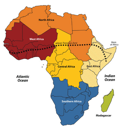 Africa is divided into regions along traditional boundaries.
These core urban areas attract people with large families from rural peripheral areas seeking employment. Millions of people in Africa who seek employment migrate to the cities or even other countries to find work. These immigrants are often not of the same ethnic group as those in power. Because of the inequalities, immigrants are at a disadvantage because of governmental discriminatory policies.
These dynamics can fuel protest activities with a goal of overthrowing the powerful elite. Various ideas have been proposed to help the move towards equality. One of the most favored options is the implementation of a democratic government, where citizens have a vote.
Patterns and dynamics of people and places are repeated throughout the Sub-Saharan realm. The regions share common demographic trends of large family sizes, agrarian lifestyles, and low-income levels. The patterns of an economy based on agricultural production and mineral extraction as well as disruptive changes in political leadership are common. Each region has diverse ethnic groups and many different languages.
Christianity and Animism are the most common religions practiced south of the African Transition Zone. Whereas, Islam is widespread north of the zone. Division and civil unrest occur frequently because of the different belief systems struggling for political power. The culture of Sub-Saharan Africa is vast and complex.
Physical Geography of Sub-Saharan Africa
The African Transition Zone divides North Africa from the rest of Africa because of climatic and cultural dynamics. Dry, arid type B climates, common in the Sahara Desert, are dominant north of the zone. Tropical type A climates prevail south of the zone. Global climate changes continue to shape the continent.
The shifting sands of the Sahara are slowly moving southward toward the tropics. Desertification in the zone continues as natural conditions and human activity place pressure on the region through overgrazing and the lack of precipitation. Type B climates resurface again south of the tropics in the southern latitudes. The Kalahari and Namib Deserts are located in Southern Africa, mainly in the countries of Botswana and Namibia.
For a continent as large as Africa, Sub-Saharan Africa does not have extended mountain ranges comparable to the ranges in North America, South America, Europe, Asia, or the Antarctica. However, on the Ethiopian Highlands, the Ethiopian Plateau has an elevation as high as 15,000 feet. East Africa has a number of well-known volcanic peaks that are high in elevation. The tallest point in Africa—Mount Kilimanjaro in Tanzania near the border with Kenya—is 19,340 feet high. Nearby in Kenya, Mount Kenya is 17,058 feet high. The Rwenzori Mountains on The Congo/Uganda border reach more than 16,000 feet in elevation and create a rain shadow effect for the region.
Permanent glaciers exist on these ranges even though they are near the equator. On the western side of the continent, Mount Cameroon in Central Africa is more than 13,000 feet in elevation. The South Africa’s Cape Ranges are low-lying mountains no higher than about 6,000 feet. The continent of Africa consists of basins and plateaus without long mountain chains. The only continuous feature is the eastern rift valleys that run along the tectonic plate boundaries from the Red Sea through to South Africa.
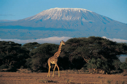 Africa has many scenic areas and many national parks set aside as game preserves, which have become major tourist attractions for world travelers.
The main rivers of Africa include the Nile, Niger, Congo, and Zambezi. The Nile River competes with the Amazon for the status as the longest river in the world. The White Nile branch begins in Lake Victoria in East Africa, and the Blue Nile branch starts in Lake Tana in Ethiopia. The Niger begins in Nigeria and flows through West Africa. The Congo River crosses the equator with a large tropical drainage basin that creates a flow of water second only to the Amazon in volume. The Zambezi River in the south is famous for the extensive Victoria Falls on the Zambia and Zimbabwe border. Victoria Falls is considered the largest waterfall in the world. Other significant rivers exist such as the Orange River, which makes up part of the border between South Africa and Namibia.
There are a number of large lakes in Sub-Saharan Africa. The largest is Lake Victoria, which borders several East African countries and is considered to be the second-largest lake in the world in surface area. Only Lake Superior in North America has a greater surface area. A number of large lakes are located in the rift valleys of the east. Three of the largest lakes along the western rift are Lake Malawi, Lake Tanganyika, and Lake Albert. To the northeast of these in Kenya is Lake Turkana, which reaches to the Ethiopian border. Lake Chad is located in the African Transition Zone on the border between Chad, Mali, and Nigeria. Lake Chad has been severely reduced in size in recent years.
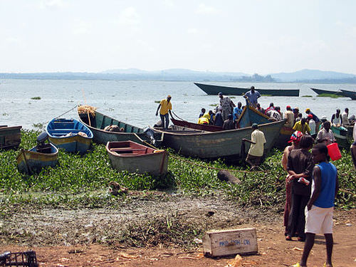 Fishers return with tilapia at Ggaba Landing Site, Lake Victoria, Uganda
The equator runs through the center of Sub-Saharan Africa, providing tropical type A climates. These regions usually have more rainfall, resulting in lighter, leached-out soils that may not be as productive as regions with richer volcanic soils, such as those found in the rift valleys. Root crops are common in Africa, as are millet and corn.
The savanna regions of the east and south have seasonal rains that affect the growing season. Soils in savanna areas are usually not as productive and cannot be depended on for the agricultural needs of growing populations. Savannas are usually grasslands or scrub forests with a seasonal precipitation pattern. Cattle and livestock grazing are common in savannas, and cattle migration follows the seasonal grazing conditions.
In specific areas of Southern Africa, larger farming operations exist in type C climates. However, Sub-Saharan Africa does not have large regions of rich alluvial soils found in the Northern Hemisphere. The ever-growing agrarian population has always depended on the land for food and sustenance, but these conditions are not favorable for Africa’s future. Populations are growing faster than any increase in agricultural production.
Increasing populations in Sub-Saharan Africa are depleting the natural environment. Deforestation is occurring in areas where firewood is in high demand and trees are cut down faster than they can grow back. Expanding human populations are also encroaching on the natural biodiversity for which the African continent is renowned.
Animals such as rhinoceroses, elephants, and lions have been hunted to near extinction. The creation of game preserves and national parks has stemmed this tide, but poaching remains a serious problem even in these protected areas. Gorilla and chimpanzee populations have also been stressed by human population growth. These animals are being killed by humans for bush meat, and their habitats are being reduced by human activities.
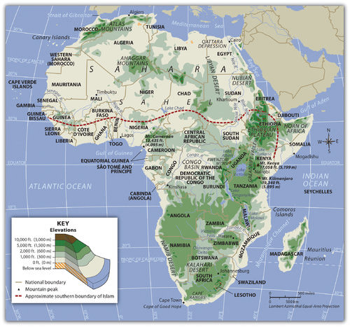 Sub-Saharan Africa does not have long mountain chains such as those found in the other continents. The Nile, Congo, and Niger Rivers are the main waterways. The Namib and Kalahari are the main deserts south of the African Transition Zone. The Great Rift Valleys are the longest physical features in East Africa.
Nile River Civilization
Human civilization also emerged along the Nile River valley of what is now Egypt. The pyramids and the Sphinx in the Giza Plateau just outside Cairo stand testimony to the human endeavors that took place here. Spring flooding of the Nile River brought nutrients and water to the land along the Nile Valley. The land could produce excess food, which subsequently led to the ability to support a structured, urbanized civilization.
The Nile River is the "lifeblood" of the region. In the fifth century B.C.E., the ancient Greek historian Herodotus suggested that Egypt was “the gift of the Nile.” The dating for the beginning of the civilization along the Nile River is often in question, but Egyptologists estimate the first dynasty ruled both Upper and Lower Egypt around 3100 B.C.E. Upper Egypt is in the south and Lower Egypt is in the north because the Nile River flows north. The terms “Upper” and “Lower” refer to elevation.
Geologists, using the erosion patterns of the Sphinx, estimate that it was constructed about 10,000 B.C.E. The ability of humans to harness the potential of the environment set the stage for technological advancements that continue to this day. The Egyptian civilization flourished for thousands of years and gave birth to a legacy that influenced their neighbors in the region, who benefited from their advancements
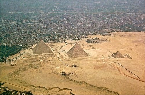 From north to south: parts of the city of Giza, the Giza Necropolis, and part of the Giza plateau.
The human activities that created the civilizations in Mesopotamia and along Egypt’s Nile River gave humanity a rich heritage to help us understand our history. Many of our legends, stories, and myths have their origins in these cultures. Their cultural developments provided the basis for much of the Western world’s religious beliefs and early philosophical ideas.
The engineering feats needed to create the magnificent temples and pyramids have by themselves been studied and analyzed over the centuries. They give modern scientists and scholars a reason to pause and recognize the high level of organization and structure that went into developing and managing these civilizations. Various aspects of science and the arts were being developed by these ancient people. Writing, mathematics, engineering, and astronomy were becoming highly advanced. Artifacts such as clay tablets and hieroglyphs are still being discovered and interpreted. They shed additional light on the advancements of these civilizations and their contribution to our human civilization.
Kingdoms, Empires, and the Slave Trade
West Africa was home to a number of large empires that shaped the culture and people of present-day Africa. The Ghana Empire (790–1076 C.E.) was responsible for one of the early consolidations of power in West Africa. Though its power and wealth were vast, it was only the first of a number of empires to arise in the region. After the Ghana Empire came the Mali Empire (1230–1600 C.E.), which was known for its wealth and size. The empire held major mining operations including gold, copper, and salt. Expanding along the Niger River and to the Atlantic coast, the Mali Empire extended over an area the size of Western Europe. Originally a federation of local groups, the empire incorporated many smaller provinces or kingdoms and had a major influence on the region’s laws and cultural heritage.
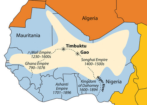 The main empires of West Africa are indicated on this map. The shaded region indicates the furthest expanse of the Songhai Empire at its peak in the 16th century.
One of the indigenous states that evolved out of the Mali Empire was that of the Songhai people, who were located to the east of the main Mali Empire. The Songhai had been based around the city of Gao for centuries. In the 15th century, they established the Songhai Empire, one of the largest empires in African history. The city of Timbuktu became prominent during this period as an urban center, and its educational institutions became well known. In the end, the Songhai Empire was defeated by Moroccan Berber forces that splintered the empire into many smaller kingdoms and ethnic clans.
South of the empires of the Niger River were coastal kingdoms, including the Ashanti and the Dahomey, which flourished during the colonial era. The local African groups had to contend with the colonial European traders and invaders, which had superior weapons and different technology. Besides the mining resources of gold, copper, salt, and ivory, the slave trade was a driving force that attracted trade ships from various European countries.
The Ashanti Empire was located along the Atlantic coast in an inland region of what is now Ghana and Ivory Coast. This area served as a trading corridor where goods from the northern regions crossed to make their way to the coastal trading towns. The Ashanti Empire took advantage of the trade opportunities and became wealthy. By the time the Europeans arrived, Ashanti trade relationships were well established and capable of supplying the colonial ships with slaves, ivory, and gold. The coastal area of Ghana was known as the Gold Coast during colonial times. Similarly, the country of Ivory Coast (Côte d’Ivoire) got its name from its participation in the elephant ivory trade.
This region of West Africa bordering the Atlantic was called the Slave Coast because of the high number of local people from this area who were sold into the European slave trade and shipped to the Americas. The once powerful Kingdom of Dahomey, east of the Ashanti Empire, was heavily involved in the slave trade. Slave trading with Europeans brought them rifles and other firearms that were useful in conflicts with their enemies. A major slave state along the Slave Coast, the kingdom became hated for selling its war captives into transatlantic slavery rather than killing them, as was the custom in warfare. The Kingdom of Dahomey became the country of Benin after the colonial era.
The slave trade brought wealth to many of the slave-trading kingdoms on the African coast. The demand for slaves pushed many of the African kingdoms to expand their slave-trading activities, capturing more individuals whom they could sell to European slave traders. Millions of Africans were captured by other Africans to be sold into slavery, placed on ships, and sent to slave owners in the Americas. The total number sold into the Atlantic slave trade will never be known, but estimates range between 10 and 12 million.
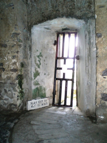 Slaves kept for shipment were held in dungeons awaiting the arrival of the slave ships. This was the last doorway that slaves from Elmina, Ghana, saw on their way from the dungeon to the slave ship.
States and kingdoms existed throughout Sub-Saharan Africa. Early kingdoms flourished in the region that is now Ethiopia. East Africa’s Axum Empire was an example of the powers of the early African savanna kingdoms located in the east.
The struggles between Islam and Christianity divided the region and gave way to the African Transition Zone, which serves as the dividing line between the two religions. Ethiopia has retained its Christian heritage, while to the north and east Islam has prevailed.
South of the equator, the ruins of Great Zimbabwe give testimony to the regional base of power that existed there in centuries past. The Zulu Empire thrived in the 19th century in the region that is now South Africa.
Colonialism in Sub-Saharan Africa
Wherever you go in the world, the impact of European colonialism is evident. Sub-Saharan Africa was broadly affected by colonial activities, the legacy of which can be recognized to this day. Colonial powers of Europe ventured into Africa to claim colonies. Many African groups were instrumental in capturing and holding slaves to trade with the European merchants.
By 1900, European colonial powers had claimed most of Africa. Only the Kingdom of Ethiopia and the area of Liberia, which was established as a home for freed slaves, remained independent. In 1884, Otto von Bismarck of Germany hosted the Berlin Conference, which to a great degree determined how Africa was colonized. This conference included 14 colonial European countries and the United States, and its purpose was to divide Africa and agree on colonial boundary lines.
Germany had few claims in Africa. Bismarck was hoping to benefit by playing the other countries against each other. At the time, more than 80 percent of Africa remained free of colonial control. On a large map of Africa, claims were argued over and boundary lines were drawn according to European agreements.
There was little regard for the concerns of local ethnic groups. Colonial boundaries divided communities into separate colonies. Ethnic boundaries were disregarded. Often-warring groups were placed together in the same colony. The Europeans, seeking profits from cheap labor and resources, did not consider the local people or culture and often employed brutal measures to subdue the local people. Most of the current borders in Africa are a result of the Berlin Conference, and many of the geopolitical issues that confront Africa today can be traced back to this event specifically and to colonialism in general.
European colonialism remained strong in Africa until the end of World War II, which left many European countries economically depleted. In 1945, the United Nations (UN) was established. One of the primary UN objectives was to oversee the decolonization of European colonies. However, colonialism in Sub-Saharan Africa lingered on. It was not until the 1990s that the last colony was finally freed.
The transition from colonies to independent nations created conflict. Civil wars were fought over who would be in power after the Europeans left. The transition to full independence has exacted a heavy toll from African countries but has resulted in stronger political structures and greater democratic liberties in many cases. The first country to gain independence in Sub-Saharan Africa was Ghana in 1957.
During the era of independence after World War II, the Cold War between the United States and the Soviet Union enticed many of the African countries to support one or the other of the superpowers. The political pressure that divided African countries during the Cold War has persisted and is the basis of some of the current political problems. The European countries extracted raw materials and minerals from their African colonies, as well as slave labor.
Varying degrees of attention were given to education, medical care, and infrastructure development. The dependency that a colony had on a European country for economic income in some cases continued long after independence and currently continues. On the other hand, major technology transfers from Europe to Africa infused greater efficiencies into Africa’s economic activities. Colonialism and the Cold War did bring about, in an unfortunate manner, the benefits of structured governments and greater democratic processes for many areas of the realm.
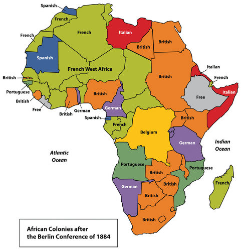 European Colonies in Africa, 1884
From Colonialism to Independence
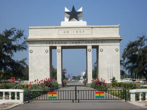 The Independence Arch in Accra, Ghana, built to commemorate Ghana's independence. The national motto, Freedom and Justice, is boldly inscribed at the top of the arch.
The transition from European colony to an independent state has not necessarily been a civil transition for African countries. Likewise, independent African countries have struggled to create stable governments or peaceful conditions—though stable governments and peaceful conditions have been established in some cases. In nearly all cases, removing the colonial powers from Africa was only half of the battle toward independence. The other half was establishing a functional, effective government.
Though each country has taken a slightly different path, most former colonies have endured civil unrest, conflict, or warfare in their push for stable governments. Coups, fraudulent elections, military regimes, and corruption have plagued the leadership in a number of African countries. Civil unrest usually precedes a change in leadership, and political power regularly changes hands by a military coup or an overthrow of the current leader.
The realm has had difficulty developing and maintaining effective political systems with democratic leadership. Political leaders have come and gone, many have been replaced before their terms were over, and a few have stayed long after their terms ended. When a leader is elected democratically, it is common to have widespread accusations of corruption, voter fraud, or ballot box scandals. Such government mismanagement and corruption have been common problems.
After the colonial era, it was not uncommon for new leaders to be connected to the old colonial power and to adopt the language and business arrangements of the European colonizer. This gave them an advantage over their competitors and provided a means of income gained by the support of their former European colonial business partners. The colonial business partners often wanted to keep ties with their former colonies to continue to profit from their resources. Many of these leaders stayed in power because of military backing or authoritarian rule funded by the profits from selling minerals or resources to their former colonial masters.
A few countries are still struggling to bring about some type of order and unity. However, there have been democratic and relatively stable progressive governments in Africa that have emerged from the transition in recent years. This is a hopeful trend for the future.
It is important to note that the objective of colonialism was to connect a colony with the homeland, not to connect African countries to each other. The legacy of this paradigm is that there is little cooperation between African countries today. Each individual country interacts more with its European colonial counterpart with regard to trade, economics, and cultural dynamics.
European colonialism isolated African countries from each other. Colonial powers often built new port cities to extract goods and resources from their colonies. They also developed transportation systems from the new ports to the interior to collect the resources and bring them back to the port. However, the colonial powers did not build a network of transportation systems that connected the region as a whole.
The current wave of globalization based on corporate colonialism continues to encourage the same pattern of discouraging interaction between countries in Africa. Instead, there is a concentration on trading with more economically powerful non-African countries. Most of the interaction between countries is a result of crisis or warfare, in which case large numbers of refugees cross the border into neighboring countries for personal survival or security.
To begin to work together and promote trade, common transportation, security, and industry, 15 West African states came together in 1975 to create the Economic Community of West African States (ECOWAS). Since then, additional political and economic agreements have been signed by various African countries. In 2001, the more expansive African Union was created to help African states compete in the international marketplace.
- Sub-Saharan Africa includes the African Transition Zone and the regions south of the Sahara. The African Transition Zone is a transitional zone between type A and type B climates and between the religions of Islam and Christianity.
- Sub-Saharan Africa is a realm of plateaus and basins with four main river systems. Mountain ranges, volcanic peaks, and large lakes are found in or along the rift valleys of eastern Africa. The rift valleys were created by tectonic activity.
- Before the colonial era, many African kingdoms dominated regions of Sub-Saharan Africa. West Africa had a number of great kingdoms. Kingdoms along the coast contributed to the slave trade.
- European countries colonized almost the entire realm of Sub-Saharan Africa. European powers made agreements during the 1884 Berlin Conference to divide the realm and create boundary lines between their African colonies. Many of the lines remain as the current borders today.
- Colonies were designed to provide labor and resources to the homeland. Port cities, transportation systems, and other infrastructure were implemented to benefit the imperial power without regard for the development of the colony.
- African colonies received independence after World War II. The transition from colonies to independent countries has been plagued by civil war, political chaos, or economic devastation.
Vocabulary Terms
|
A meeting of European Nations in 1884-1885 at which countries agreed on the rules in colonizing Africa. The Europeans did not take into account existing boundaries and/or ethnic divisions. |
|
|
White water rapids that can also include waterfalls |
|
|
Tropical rain forest located in Central Africa. The Congo River runs through this basin. |
|
|
The largest lake in Africa, it is the source of the Nile River |
|
|
Africa's tallest peak, a volcano located in Tanzania |
|
|
A valley created by the moving apart of tectonic plates. This exists in East Africa. |
|
|
Largest desert in the world measuring over 3,000 miles across Northern Africa |
|
|
Flat, grassy, mostly treeless plains located in the tropical regions of Africa |
Applying Knowledge
Interactive Notebook Activities
- Determine which of the countries in Sub-Saharan Africa are now experiencing civil war or national unrest over political leadership.
- Analyze which countries of the realm have the most stable governments.
Discussion and Study Questions
- What are the main boundaries that define Sub-Saharan Africa?
- Where is the African Transition Zone? What are the main transitions that this zone represents?
- What geological phenomenon has created the rift valleys of the east? What physical geographic features are found here?
- What are some of the general environmental issues that can be found throughout the realm of Sub-Saharan Africa?
- Name the African kingdoms that were involved in the supply of humans for the European slave trade.
- How did imperial powers in Africa cultivate their colonies’ dependence on the mother countries?
- When did the colonies in Sub-Saharan Africa gain their independence?
- What has been the usual pattern of transition from colonies to independent countries?
- What country was the first in Sub-Saharan Africa to gain its independence? In what year did it gain independence?
- How are the Sub-Saharan African countries continually isolated from their neighbors in the global economy?
Real-World Geography Exercise
- Using Google Maps, complete the following activities:
- Locate each place on the bulleted list below.
- Find the nearest city with an international airport in proximity to each location on the bulleted list below.
- Calculate the distance and travel time by plane to each city from the Denver International Airport.
- Using NASA Latitude and Longitude Finder, determine the latitude and longitude for each location on the bulleted list below.
- Be prepared to share and discuss your answers.
- African Transition Zone
- Blue Nile
- Cape of Good Hope
- Cape Ranges
- Central Africa
- Congo River
- East Africa
- Ethiopian Plateau
- Kalahari Desert
- Lake Albert
- Lake Chad
- Lake Malawi
- Lake Tana
- Lake Tanganyika
- Lake Turkana
- Lake Victoria
- Madagascar
- Mt. Cameroon
- Mt. Kilimanjaro
- Namib Desert
- Niger River
- Rwenzori Mountains
- Southern Africa
- Timbuktu
- Victoria Falls
- West Africa
- White Nile
- Zambezi River
Videos for Geography Enrichment
Helpful Websites for the Study of Geography
Canadian Encyclopedia is an encyclopedia funded by the Canadian government covering all branches of knowledge. Their scholarly collection includes interactive materials.
CIA World Factbook provides information on the people, history, government, economy, energy, geography, communications, transportation, military, and transnational issues for the world's entities.
Congress.gov is a US government website where you can find federal legislation, past and present, as well as information about the US legal system.
Drug Enforcement Administration (DEA) is a government agency website that provides current news, resources, topics of interest, information about drugs, careers in the DEA, and a tip hotline.
Library of Congress is the largest library in the world and provides manuscripts, files, information, pictures, and videos.
NASA Earth Observatory (NEO) is a US government agency website that allows users to search for and retrieve satellite images of Earth.
National Archives is a US government website that provides historical documents, photos, records, publications, and educator resources.
National Oceanic and Atmospheric Association (NOAA) is a US government agency website that provides weather-related information and ocean research.
National Map is a website by the United States Geological Survey and other federal, state, and local agencies that delivers topographic information for the United States.
NationMaster is a massive central data source and a handy way to graphically compare nations.
Real-Time World Air Quality Index is a website that measures most locations in the world for air pollution in real time.
StateMaster is a unique statistical database, which allows you to research and compare a multitude of different data on US states.
United Nations (UN) is an international organization founded in 1945 and made up of 193 member states. The UN maintains international peace and security, protects human rights, delivers humanitarian aid, promotes sustainable development, and upholds international law.
United States Census Bureau is a US government agency that provides a population clock, data, surveys, statistics, a library with information and infographics, news about the economy, and much more.
United States Geological Survey (USGS) is a US government agency website that provides scientific information about the natural hazards that threaten lives, the natural resources we rely on, the health of our ecosystems and environment, and the impacts of climate and land-use change.
Whitehouse.gov is a US government website that provides the latest presidential news, information about the budget, policy, defense, and many more topics.
World Health Organization (WHO) is under the United Nations and provides leadership on matters critical to health, shapes the research agenda on health, and monitors the health situation and assessing health trends around the world. Their website provides information on the state of health around the world, outbreaks, current health news, and more.
World Trade Organization (WTO) is an intergovernmental organization that regulates international trade. The website provides information on the history of the multilateral trading system, featured videos, news and events, trade topics, and more.

