
11.1: Australia and New Zealand- Introducing the Realm (1 Day)
- Page ID
- 1987
\( \newcommand{\vecs}[1]{\overset { \scriptstyle \rightharpoonup} {\mathbf{#1}} } \)
\( \newcommand{\vecd}[1]{\overset{-\!-\!\rightharpoonup}{\vphantom{a}\smash {#1}}} \)
\( \newcommand{\id}{\mathrm{id}}\) \( \newcommand{\Span}{\mathrm{span}}\)
( \newcommand{\kernel}{\mathrm{null}\,}\) \( \newcommand{\range}{\mathrm{range}\,}\)
\( \newcommand{\RealPart}{\mathrm{Re}}\) \( \newcommand{\ImaginaryPart}{\mathrm{Im}}\)
\( \newcommand{\Argument}{\mathrm{Arg}}\) \( \newcommand{\norm}[1]{\| #1 \|}\)
\( \newcommand{\inner}[2]{\langle #1, #2 \rangle}\)
\( \newcommand{\Span}{\mathrm{span}}\)
\( \newcommand{\id}{\mathrm{id}}\)
\( \newcommand{\Span}{\mathrm{span}}\)
\( \newcommand{\kernel}{\mathrm{null}\,}\)
\( \newcommand{\range}{\mathrm{range}\,}\)
\( \newcommand{\RealPart}{\mathrm{Re}}\)
\( \newcommand{\ImaginaryPart}{\mathrm{Im}}\)
\( \newcommand{\Argument}{\mathrm{Arg}}\)
\( \newcommand{\norm}[1]{\| #1 \|}\)
\( \newcommand{\inner}[2]{\langle #1, #2 \rangle}\)
\( \newcommand{\Span}{\mathrm{span}}\) \( \newcommand{\AA}{\unicode[.8,0]{x212B}}\)
\( \newcommand{\vectorA}[1]{\vec{#1}} % arrow\)
\( \newcommand{\vectorAt}[1]{\vec{\text{#1}}} % arrow\)
\( \newcommand{\vectorB}[1]{\overset { \scriptstyle \rightharpoonup} {\mathbf{#1}} } \)
\( \newcommand{\vectorC}[1]{\textbf{#1}} \)
\( \newcommand{\vectorD}[1]{\overrightarrow{#1}} \)
\( \newcommand{\vectorDt}[1]{\overrightarrow{\text{#1}}} \)
\( \newcommand{\vectE}[1]{\overset{-\!-\!\rightharpoonup}{\vphantom{a}\smash{\mathbf {#1}}}} \)
\( \newcommand{\vecs}[1]{\overset { \scriptstyle \rightharpoonup} {\mathbf{#1}} } \)
\( \newcommand{\vecd}[1]{\overset{-\!-\!\rightharpoonup}{\vphantom{a}\smash {#1}}} \)
\(\newcommand{\avec}{\mathbf a}\) \(\newcommand{\bvec}{\mathbf b}\) \(\newcommand{\cvec}{\mathbf c}\) \(\newcommand{\dvec}{\mathbf d}\) \(\newcommand{\dtil}{\widetilde{\mathbf d}}\) \(\newcommand{\evec}{\mathbf e}\) \(\newcommand{\fvec}{\mathbf f}\) \(\newcommand{\nvec}{\mathbf n}\) \(\newcommand{\pvec}{\mathbf p}\) \(\newcommand{\qvec}{\mathbf q}\) \(\newcommand{\svec}{\mathbf s}\) \(\newcommand{\tvec}{\mathbf t}\) \(\newcommand{\uvec}{\mathbf u}\) \(\newcommand{\vvec}{\mathbf v}\) \(\newcommand{\wvec}{\mathbf w}\) \(\newcommand{\xvec}{\mathbf x}\) \(\newcommand{\yvec}{\mathbf y}\) \(\newcommand{\zvec}{\mathbf z}\) \(\newcommand{\rvec}{\mathbf r}\) \(\newcommand{\mvec}{\mathbf m}\) \(\newcommand{\zerovec}{\mathbf 0}\) \(\newcommand{\onevec}{\mathbf 1}\) \(\newcommand{\real}{\mathbb R}\) \(\newcommand{\twovec}[2]{\left[\begin{array}{r}#1 \\ #2 \end{array}\right]}\) \(\newcommand{\ctwovec}[2]{\left[\begin{array}{c}#1 \\ #2 \end{array}\right]}\) \(\newcommand{\threevec}[3]{\left[\begin{array}{r}#1 \\ #2 \\ #3 \end{array}\right]}\) \(\newcommand{\cthreevec}[3]{\left[\begin{array}{c}#1 \\ #2 \\ #3 \end{array}\right]}\) \(\newcommand{\fourvec}[4]{\left[\begin{array}{r}#1 \\ #2 \\ #3 \\ #4 \end{array}\right]}\) \(\newcommand{\cfourvec}[4]{\left[\begin{array}{c}#1 \\ #2 \\ #3 \\ #4 \end{array}\right]}\) \(\newcommand{\fivevec}[5]{\left[\begin{array}{r}#1 \\ #2 \\ #3 \\ #4 \\ #5 \\ \end{array}\right]}\) \(\newcommand{\cfivevec}[5]{\left[\begin{array}{c}#1 \\ #2 \\ #3 \\ #4 \\ #5 \\ \end{array}\right]}\) \(\newcommand{\mattwo}[4]{\left[\begin{array}{rr}#1 \amp #2 \\ #3 \amp #4 \\ \end{array}\right]}\) \(\newcommand{\laspan}[1]{\text{Span}\{#1\}}\) \(\newcommand{\bcal}{\cal B}\) \(\newcommand{\ccal}{\cal C}\) \(\newcommand{\scal}{\cal S}\) \(\newcommand{\wcal}{\cal W}\) \(\newcommand{\ecal}{\cal E}\) \(\newcommand{\coords}[2]{\left\{#1\right\}_{#2}}\) \(\newcommand{\gray}[1]{\color{gray}{#1}}\) \(\newcommand{\lgray}[1]{\color{lightgray}{#1}}\) \(\newcommand{\rank}{\operatorname{rank}}\) \(\newcommand{\row}{\text{Row}}\) \(\newcommand{\col}{\text{Col}}\) \(\renewcommand{\row}{\text{Row}}\) \(\newcommand{\nul}{\text{Nul}}\) \(\newcommand{\var}{\text{Var}}\) \(\newcommand{\corr}{\text{corr}}\) \(\newcommand{\len}[1]{\left|#1\right|}\) \(\newcommand{\bbar}{\overline{\bvec}}\) \(\newcommand{\bhat}{\widehat{\bvec}}\) \(\newcommand{\bperp}{\bvec^\perp}\) \(\newcommand{\xhat}{\widehat{\xvec}}\) \(\newcommand{\vhat}{\widehat{\vvec}}\) \(\newcommand{\uhat}{\widehat{\uvec}}\) \(\newcommand{\what}{\widehat{\wvec}}\) \(\newcommand{\Sighat}{\widehat{\Sigma}}\) \(\newcommand{\lt}{<}\) \(\newcommand{\gt}{>}\) \(\newcommand{\amp}{&}\) \(\definecolor{fillinmathshade}{gray}{0.9}\)- Summarize how colonialism has affected the development and socioeconomic conditions of Australia and New Zealand.
- Understand how isolation has allowed for the high level of biodiversity.
- Outline how colonialism impacted the Maori and the Aboriginal populations.
TEKS Regional Unit 11 Oceania: Chapter 11.1 Australia and New Zealand; Introducing the Realm
- WG.2A Describe the human and physical characteristics of the same regions at different periods of time to evaluate relationships between past events and current conditions.
- WG.4C Explain the influence of climate on the distribution of biomes in different regions.
- WG.6A Locate and describe human and physical features that influence the size and distribution of settlements.
- WG.6B Explain the processes that have caused changes in settlement patterns, including urbanization, transportation, access to and availability of resources, and economic activities.
- WG.7B Explain how political, economic, social, and environmental push and pull factors and physical geography affect the routes and flows of human migration.
- WG.7D Examine the benefits and challenges of globalization, including connectivity, standard of living, pandemics, and loss of local culture.
- WG.8A Compare ways that humans depend on, adapt to, and modify the physical environment, including the influences of culture and technology.
- WG.22C Use geographic terminology correctly.
- WG.22D Use standard grammar, spelling, sentence structure, and punctuation.
TEKS and ELPS for Regional World Geography Unit 11--Oceana from TEKS Resource System.
Australia and New Zealand: Introducing the Realm
Isolation Geography
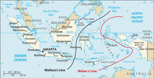 Wallace’s and Weber’s Lines were developed independently to account for the differences in biodiversity between the Austral realm and the Asian realm.
The historic isolation of New Zealand and Australia from the rest of the world has caused animals and organisms that are not found anywhere else to develop in these two countries. The unique biodiversity includes marsupials, such as kangaroos, wallabies, koalas, and bandicoots. It is believed that these creatures developed separately after the continents broke away from each other more than 200 million years ago.
Many plant species are also unique to this realm. The biodiversity found here is separate from that of Asia. This has been explained by various bio-geographers by drawing imaginary lines just north of Australia to indicate the line of division between the Asian realm and the Austral realm. Wallace’s Line and Weber’s Line are two such examples. Both examples attempt to establish the correct line of demarcation for the differences in species development between the two sides.
During the ice ages, sea level was lower, and the many islands of Southeast Asia were connected by land to the mainland. Papua New Guinea was connected to Australia. Wallace and Weber believed that no land bridge connected the Asian side with the Austral side for animals to cross over. This separation caused the organisms to the south to develop independently of those in the north. For example, marsupials are not found on the Asian side of these lines but are found on the Australian side.
Colonialism
New Zealand and Australia were both inhabited before the era of European colonialism. Aboriginal people are said to have migrated to Australia across Southeast Asia from the mainland of Asia more than 40,000 years ago. They made Australia their home and adapted to the physical geography of the continent. For tens of thousands of years before the Europeans arrived, the Aboriginal people carved out an existence in Australia and developed their cultural ways. The arrival of the Europeans had caused a serious demise in the Aboriginal population. Aborigines were completely decimated in Tasmania. Only about 450,000 Aboriginal peoples remain in Australia today.
New Zealand was inhabited by the Polynesian group called the Maori, who established themselves on the islands in the 10th century. For hundreds of years, they established their culture and traditions in the region before the Europeans arrived. The Aborigines in Australia and the Maori in New Zealand were both confronted with the European invaders.
From their standpoint, there was much to lose by the arrival of the Europeans. Lands were lost, new diseases killed many, and control of their methods of livelihood were taken over by Europeans. The Maori initiated a number of wars against British colonizers, but in the end the greater military power gained the advantage. At the present time, the Maori are approximately 14 percent of the population of New Zealand.
The sighting of Australia by the Dutch dates to 1606. Portuguese explorers may have discovered Australia earlier, but there are no written records. In the early 1700s, the northern and western coastlines of Australia were known as “New Holland.” There were no established colonies. James Cook, a naval officer working for the British navy, commanded the ship Endeavor and mapped Australia’s eastern coast in 1770. He made port at Botany Bay, just south of the current city of Sydney and claimed the region for Britain. He named the land New South Wales. The charting of the coast resulted in continued attention being paid to the region.
Meanwhile, England had a severe problem with overcrowding of its prisons. This problem was made worse by the loss of Britain’s American colonies. Upon Cook’s return to England, interest was generated in the concept of relieving prison overcrowding by sending prisoners to Australia. In 1787, eleven ships with 750 convicts sailed from Great Britain to Botany Bay.
Penal colonies were established in Australia. By the end of the 17th century, the entire Australian continent was under the British Crown. At the same time that the movement of prisoners from England to Australia was getting smaller, the next wave of immigration was being fueled by the discovery of gold in the 1850s. The practice of transferring prisoners to Australia ended in 1868.
In 1901, the various territories and states of Australia came together under one federation called the Commonwealth of Australia. A new federal capital city of Canberra was proposed. By 1927, Canberra was ready for government activity. This commonwealth government still allowed for individual state differences. The British monarch is considered the head of state, though it is mainly a ceremonial position. There have been movements within Australia in recent years to separate from the British Crown, but they have not been approved. Australia has a democratically elected government.
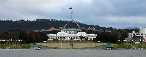 Two of Canberra's best-known landmarks, Parliament House and Old Parliament House.
British naval officer James Cook mapped the coastline of New Zealand in 1769. As the colonial era emerged, Great Britain took possession of New Zealand and included it with its colony of New South Wales. In the 1840s, New Zealand became a separate crown colony. The colony developed a local parliament and a representative government. By 1893, New Zealand made headlines as the first country in the world granting all women the right to vote. As a part of the British Empire, the country was made a commonwealth nation in 1947 and has been functioning independently ever since.
- Australia is an island continent that was home to aboriginal people who have lived there for tens of thousands of years.
- The British colonized Australia by first creating prison colonies for convicts from Great Britain.
- New Zealand has two main islands and is home to the Maori, who were originally from Polynesia.
- The British colonized New Zealand and often were in conflict with the Maori.
- Australia is relatively flat with low elevation highlands and an extensive dry interior, while New Zealand has high mountains and receives adequate rainfall.
- The Austral realm was isolated by physical geography. Weber’s Line and the Wallace Line were both attempts to distinguish the location of the separation between biological environments.
Vocabulary Terms
|
Aboriginal Peoples |
an original inhabitant of Australia. |
|
Great Barrier Reef |
a 1,250-mile chain of coral reefs off the coast of Australia. |
|
Great Dividing Range |
a range of low mountains in Australia |
|
James Cook |
a British explorer who claimed land in Australia |
|
marsupial |
an animal with an abdominal pouch to carry its young |
|
The arid, sparsely populated interior region of Australia |
|
|
Penal Colony |
a settlement that serves as a prison |
|
Treaty of Waitangi |
a treaty between the British and the Maori signed in 1840 |
|
Biodiversity |
Characterized by a variety of plants and animals |
|
Atoll |
Islands created from coral |
|
Volcano |
A mountain on the Earth’s surface that periodically erupts sending rock, ash, and lava onto the surface environment of the Earth |
Applying Knowledge
Discussion and Study Questions
- For what purpose was Australia first colonized? What European country colonized Australia and New Zealand?
- How did the colonial activity impact the indigenous people?
- How is the Austral realm isolated from the rest of the world?
- Who are the main indigenous people of New Zealand and from where did they originally come?
- Explain how the colonial development of Australia was similar to the colonial development of the United States.
Real-World Geography Exercise
- Using Google Maps, complete the following activities:
- Locate each place on the bulleted list below.
- Find the nearest city with an international airport in proximity to each location on the bulleted list below.
- Calculate the distance and travel time by plane to each city from the Minneapolis-St. Paul International Airport in Minneapolis-St. Paul, Minnesota
- Using NASA Latitude and Longitude Finder, determine the latitude and longitude for each location on the bulleted list below.
- Be prepared to share and discuss your answers.
- Arafura Sea
- Cape York
- Coral Sea
- Great Australian Bight
- Great Barrier Reef
- Gulf of Carpentaria
- New South Wales
- Sydney
- Tasman Sea
- Tasmania
Videos for Geography Enrichment
Helpful Websites for the Study of Geography
Canadian Encyclopedia is an encyclopedia funded by the Canadian government covering all branches of knowledge. Their scholarly collection includes interactive materials.
CIA World Factbook provides information on the people, history, government, economy, energy, geography, communications, transportation, military, and transnational issues for the world's entities.
Congress.gov is a US government website where you can find federal legislation, past and present, as well as information about the US legal system.
Drug Enforcement Administration (DEA) is a government agency website that provides current news, resources, topics of interest, information about drugs, careers in the DEA, and a tip hotline.
Library of Congress is the largest library in the world and provides manuscripts, files, information, pictures, and videos.
NASA Earth Observatory (NEO) is a US government agency website that allows users to search for and retrieve satellite images of Earth.
National Archives is a US government website that provides historical documents, photos, records, publications, and educator resources.
National Oceanic and Atmospheric Association (NOAA) is a US government agency website that provides weather-related information and ocean research.
National Map is a website by the United States Geological Survey and other federal, state, and local agencies that delivers topographic information for the United States.
NationMaster is a massive central data source and a handy way to graphically compare nations.
Real-Time World Air Quality Index is a website that measures most locations in the world for air pollution in real time.
StateMaster is a unique statistical database, which allows you to research and compare a multitude of different data on US states.
United Nations (UN) is an international organization founded in 1945 and made up of 193 member states. The UN maintains international peace and security, protects human rights, delivers humanitarian aid, promotes sustainable development, and upholds international law.
United States Census Bureau is a US government agency that provides a population clock, data, surveys, statistics, a library with information and infographics, news about the economy, and much more.
United States Geological Survey (USGS) is a US government agency website that provides scientific information about the natural hazards that threaten lives, the natural resources we rely on, the health of our ecosystems and environment, and the impacts of climate and land-use change.
Whitehouse.gov is a US government website that provides the latest presidential news, information about the budget, policy, defense, and many more topics.
World Health Organization (WHO) is under the United Nations and provides leadership on matters critical to health, shapes the research agenda on health, and monitors the health situation and assessing health trends around the world. Their website provides information on the state of health around the world, outbreaks, current health news, and more.
World Trade Organization (WTO) is an intergovernmental organization that regulates international trade. The website provides information on the history of the multilateral trading system, featured videos, news and events, trade topics, and more.
| Image | Reference | Attributions |
|
[Figure 1] | Credit: open.lib.umn.edu Source: http://open.lib.umn.edu/worldgeography/wp-content/uploads/sites/181/2016/04/b5c18b60a7b06917ede5a0f7b6760da2.jpg License: CC BY-NC 3.0 |
|
[Figure 2] | Credit: CC BY-SA 3.0, https://commons.wikimedia.org/w/inde...p?curid=984891 Source: https://en.Wikipedia.org/wiki/Canberra#/media/File:Lake-ParlHouse.JPG License: CC BY-NC 3.0 |