11.2: Australia (3 Days)
- Page ID
- 1988
\( \newcommand{\vecs}[1]{\overset { \scriptstyle \rightharpoonup} {\mathbf{#1}} } \)
\( \newcommand{\vecd}[1]{\overset{-\!-\!\rightharpoonup}{\vphantom{a}\smash {#1}}} \)
\( \newcommand{\dsum}{\displaystyle\sum\limits} \)
\( \newcommand{\dint}{\displaystyle\int\limits} \)
\( \newcommand{\dlim}{\displaystyle\lim\limits} \)
\( \newcommand{\id}{\mathrm{id}}\) \( \newcommand{\Span}{\mathrm{span}}\)
( \newcommand{\kernel}{\mathrm{null}\,}\) \( \newcommand{\range}{\mathrm{range}\,}\)
\( \newcommand{\RealPart}{\mathrm{Re}}\) \( \newcommand{\ImaginaryPart}{\mathrm{Im}}\)
\( \newcommand{\Argument}{\mathrm{Arg}}\) \( \newcommand{\norm}[1]{\| #1 \|}\)
\( \newcommand{\inner}[2]{\langle #1, #2 \rangle}\)
\( \newcommand{\Span}{\mathrm{span}}\)
\( \newcommand{\id}{\mathrm{id}}\)
\( \newcommand{\Span}{\mathrm{span}}\)
\( \newcommand{\kernel}{\mathrm{null}\,}\)
\( \newcommand{\range}{\mathrm{range}\,}\)
\( \newcommand{\RealPart}{\mathrm{Re}}\)
\( \newcommand{\ImaginaryPart}{\mathrm{Im}}\)
\( \newcommand{\Argument}{\mathrm{Arg}}\)
\( \newcommand{\norm}[1]{\| #1 \|}\)
\( \newcommand{\inner}[2]{\langle #1, #2 \rangle}\)
\( \newcommand{\Span}{\mathrm{span}}\) \( \newcommand{\AA}{\unicode[.8,0]{x212B}}\)
\( \newcommand{\vectorA}[1]{\vec{#1}} % arrow\)
\( \newcommand{\vectorAt}[1]{\vec{\text{#1}}} % arrow\)
\( \newcommand{\vectorB}[1]{\overset { \scriptstyle \rightharpoonup} {\mathbf{#1}} } \)
\( \newcommand{\vectorC}[1]{\textbf{#1}} \)
\( \newcommand{\vectorD}[1]{\overrightarrow{#1}} \)
\( \newcommand{\vectorDt}[1]{\overrightarrow{\text{#1}}} \)
\( \newcommand{\vectE}[1]{\overset{-\!-\!\rightharpoonup}{\vphantom{a}\smash{\mathbf {#1}}}} \)
\( \newcommand{\vecs}[1]{\overset { \scriptstyle \rightharpoonup} {\mathbf{#1}} } \)
\(\newcommand{\longvect}{\overrightarrow}\)
\( \newcommand{\vecd}[1]{\overset{-\!-\!\rightharpoonup}{\vphantom{a}\smash {#1}}} \)
\(\newcommand{\avec}{\mathbf a}\) \(\newcommand{\bvec}{\mathbf b}\) \(\newcommand{\cvec}{\mathbf c}\) \(\newcommand{\dvec}{\mathbf d}\) \(\newcommand{\dtil}{\widetilde{\mathbf d}}\) \(\newcommand{\evec}{\mathbf e}\) \(\newcommand{\fvec}{\mathbf f}\) \(\newcommand{\nvec}{\mathbf n}\) \(\newcommand{\pvec}{\mathbf p}\) \(\newcommand{\qvec}{\mathbf q}\) \(\newcommand{\svec}{\mathbf s}\) \(\newcommand{\tvec}{\mathbf t}\) \(\newcommand{\uvec}{\mathbf u}\) \(\newcommand{\vvec}{\mathbf v}\) \(\newcommand{\wvec}{\mathbf w}\) \(\newcommand{\xvec}{\mathbf x}\) \(\newcommand{\yvec}{\mathbf y}\) \(\newcommand{\zvec}{\mathbf z}\) \(\newcommand{\rvec}{\mathbf r}\) \(\newcommand{\mvec}{\mathbf m}\) \(\newcommand{\zerovec}{\mathbf 0}\) \(\newcommand{\onevec}{\mathbf 1}\) \(\newcommand{\real}{\mathbb R}\) \(\newcommand{\twovec}[2]{\left[\begin{array}{r}#1 \\ #2 \end{array}\right]}\) \(\newcommand{\ctwovec}[2]{\left[\begin{array}{c}#1 \\ #2 \end{array}\right]}\) \(\newcommand{\threevec}[3]{\left[\begin{array}{r}#1 \\ #2 \\ #3 \end{array}\right]}\) \(\newcommand{\cthreevec}[3]{\left[\begin{array}{c}#1 \\ #2 \\ #3 \end{array}\right]}\) \(\newcommand{\fourvec}[4]{\left[\begin{array}{r}#1 \\ #2 \\ #3 \\ #4 \end{array}\right]}\) \(\newcommand{\cfourvec}[4]{\left[\begin{array}{c}#1 \\ #2 \\ #3 \\ #4 \end{array}\right]}\) \(\newcommand{\fivevec}[5]{\left[\begin{array}{r}#1 \\ #2 \\ #3 \\ #4 \\ #5 \\ \end{array}\right]}\) \(\newcommand{\cfivevec}[5]{\left[\begin{array}{c}#1 \\ #2 \\ #3 \\ #4 \\ #5 \\ \end{array}\right]}\) \(\newcommand{\mattwo}[4]{\left[\begin{array}{rr}#1 \amp #2 \\ #3 \amp #4 \\ \end{array}\right]}\) \(\newcommand{\laspan}[1]{\text{Span}\{#1\}}\) \(\newcommand{\bcal}{\cal B}\) \(\newcommand{\ccal}{\cal C}\) \(\newcommand{\scal}{\cal S}\) \(\newcommand{\wcal}{\cal W}\) \(\newcommand{\ecal}{\cal E}\) \(\newcommand{\coords}[2]{\left\{#1\right\}_{#2}}\) \(\newcommand{\gray}[1]{\color{gray}{#1}}\) \(\newcommand{\lgray}[1]{\color{lightgray}{#1}}\) \(\newcommand{\rank}{\operatorname{rank}}\) \(\newcommand{\row}{\text{Row}}\) \(\newcommand{\col}{\text{Col}}\) \(\renewcommand{\row}{\text{Row}}\) \(\newcommand{\nul}{\text{Nul}}\) \(\newcommand{\var}{\text{Var}}\) \(\newcommand{\corr}{\text{corr}}\) \(\newcommand{\len}[1]{\left|#1\right|}\) \(\newcommand{\bbar}{\overline{\bvec}}\) \(\newcommand{\bhat}{\widehat{\bvec}}\) \(\newcommand{\bperp}{\bvec^\perp}\) \(\newcommand{\xhat}{\widehat{\xvec}}\) \(\newcommand{\vhat}{\widehat{\vvec}}\) \(\newcommand{\uhat}{\widehat{\uvec}}\) \(\newcommand{\what}{\widehat{\wvec}}\) \(\newcommand{\Sighat}{\widehat{\Sigma}}\) \(\newcommand{\lt}{<}\) \(\newcommand{\gt}{>}\) \(\newcommand{\amp}{&}\) \(\definecolor{fillinmathshade}{gray}{0.9}\)- Summarize the colonial exploitation and development of Australia.
- Understand the basic characteristics of Australia’s physical geography.
- Outline how the core-periphery spatial relationship applies to Australia.
- Describe the country’s general cultural attributes.
- Summarize the methods used for the country to gain national wealth.
TEKS Regional Unit 11 Oceania: Chapter 11.2 Australia
WG.1A Analyze the effects of physical and human geographic patterns and processes on the past and describe their impact on the present, including significant physical features and environmental conditions that influenced migration patterns and shaped the distribution of culture groups today.
WG.2A Describe the human and physical characteristics of the same regions at different periods of time to evaluate relationships between past events and current conditions.
WG.3A Explain weather conditions and climate in relation to annual changes in Earth-Sun relationships.
WG.3B Describe the physical processes that affect the environments of regions, including weather, tectonic forces.
WG.4A Explain how elevation, latitude, wind systems, ocean currents, position on a continent, and mountain barriers influence temperature, precipitation, and distribution of climate regions.
WG.4B Describe different landforms and the physical processes that cause their development.
WG.4C Explain the influence of climate on the distribution of biomes in different regions.
WG.5A Analyze how the character of a place is related to its political, economic, social, and cultural elements.
WG.6A Locate and describe human and physical features that influence the size and distribution of settlements.
WG.6B Explain the processes that have caused changes in settlement patterns, including urbanization, transportation, access to and availability of resources, and economic activities.
WG.8A Compare ways that humans depend on, adapt to, and modify the physical environment, including the influences of culture and technology.
WG.8B Describe the interaction between humans and the physical environment and analyze the consequences of extreme weather and other natural disasters such as El Nino, floods. tsunamis, and volcanoes.
WG.8C Evaluate the economic and political relationships between settlements and the environments, including sustainable development and renewable/non-renewable resources.
WG.9A Identify physical and/or human factors such as climate, vegetation, language, trade networks, political units, river systems, and religion that constitute a region.
WG.10C Compare the ways people satisfy their basic needs through the production of goods and services such as subsistence agriculture versus commercial agriculture or cottage industries versus commercial industries.
WG.10D Compare global trade patterns over time and examine the implications of globalization, including outsourcing and free trade zones.
WG.11B Identify factors affecting the location of different types of economic activities, including subsistence and commercial agriculture manufacturing, and service industries.
WG.11C Assess how changes in climate, resources, and infrastructure (technology, transportation, and communication) affect the location and patterns of economic activities.
WG.18A Analyze cultural changes in specific regions caused by migration, war, trade, innovations, and diffusion.
WG.18C Identify examples of cultures that maintain traditional ways, including traditional economies.
WG.18D Evaluate the spread of cultural traits to find examples of cultural convergence and divergence such as the spread of democratic ideas, US-based fast-food franchises, the English langue, technology, or global sports.
WG.21A Analyze and evaluate the validity and utility of multiple sources of geographic information such as primary and secondary sources, aerial photographs, and maps.
WG.21C Create and interpret different types of maps to answer geographic questions, infer relationships, and analyze change.
WG.22A Design and draw appropriate graphics such as maps, diagrams tables, and graphs to communicate geographic features, distributions, and relationships.
WG.22B Generate summaries, generalizations, and thesis statements supported by evidence.
WG.22E Create original work using proper citations and understanding and avoiding plagiarism.
TEKS and ELPS for Regional World Geography Unit 11--Oceania from TEKS Resource System.
Australia
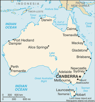 Map of Australia
Physical Geography
There is an international attraction to the island continent of Australia, and the attraction has grown in intensity in the past few decades. Tourism is now the number one economic activity in Australia. Just slightly smaller in physical area than the continental United States, Australia is a large country with many resources but few people relative to its size. The Tropic of Capricorn runs right through the middle of this country.
Australia hosts many unique species of plants and animals, including marsupials, snakes, and insects. With the advent of European colonialism, new species were introduced to the country, which caused the extinction of some of the native species but also gave Australia a wide diversity of organisms.
Australia is a relatively low-lying island with low relief. It is the flattest of all the continents. The various highland ranges are pronounced, but are not high in elevation. The Great Dividing Range is a mountain chain extending from Melbourne in the south to Cape York in the north. This low-lying range of highlands averages about 4,000 feet and reaches an elevation of just over 7,000 feet at its highest peaks in the south. The largest river in Australia is the Darling-Murray River system that starts in the highland of the Great Dividing Range and flows inward through New South Wales, Queensland, Victoria, and South Australia.
 The Great Dividing Range. The view from the peak of Mount Feathertop, facing north-east, showing the Fainters and other mountains.
 The confluence of the Darling and Murray Rivers at Wentworth, New South Wales.
The great interior of the country is home to the massive outback. Extending west from the Great Dividing Range, the outback encompasses most of the interior. This region receives less rainfall than along the coast and its terrain consists of deserts and semi-arid plateaus with rough grasses and scrublands. The outback is sparsely populated, but it is home to a number of aboriginal groups.
Many of the school-age children in the outback have traditionally received their school lessons through television or radio broadcasts because of their isolation. Mining and some agricultural activities can be found in the outback. Alice Springs is located in the center of the continent and has been given the designation of the middle of nowhere, or the center of everything.
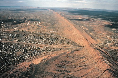 One of the larger settlements on the road that crosses Australia from north to south is Alice Springs.
The deserts of Australia’s interior make up a large portion of the continent. Western Australia has three large deserts: the Gibson Desert, Great Victoria Desert, and Great Sandy Desert. The Simpson Desert is located in the border region between the Northern Territory, Queensland, and South Australia. These deserts are not all sand. Coarse grasses and various species of Spinifex, a short plant that grows in sandy soil, also grow in the deserts.
 Dunes in the Simpson Desert near Andado, Northern Territory, Australia.
 The Great Artesian Basin on the western edge of the Great Dividing Range receives very little rainfall. It would be classified as a desert but for its underground water resources, which support extensive farming operations. Large livestock businesses exist in Australia’s interior with massive herds of cattle and sheep. The grassy plateaus and scrublands provide grazing for domesticated livestock and even wild camels.
The Great Barrier Reef, the largest barrier reef in the world, extends for 1,600 miles off the northeastern coast of Australia. It is home to a host of sea creatures and fish that draw millions of tourists each year. The reef attracts scuba divers and water enthusiasts from around the world. The reef is a main tourist attraction and brings income to the Australian economy. The Great Barrier Reef has been designated as a United Nations World Heritage Site. Brisbane is located on the Gold Coast, which gets its name from the beautiful sandy beaches. The beaches attract an important tourism market for the country.
A couple of large physical features of interest and significance to Australia are the two largest monoliths in the world. In Western Australia, more than 500 miles to the northeast of Perth, is Mount Augustus National Park, which features the rock known as Mount Augustus. It is considered to be the largest single rock in the world. Mount Augustus rises 2,352 feet above the desert landscape. The single structure is about five miles long.
.jpg?revision=1) Mount Augustus is located in the Mount Augustus National Park in Western Australia.
Mount Augustus is located in the Mount Augustus National Park in Western Australia. Uluru, also known as Ayers Rock, is located about 200 miles southwest of Alice Springs in the Northern Territory and is a well-known tourist attraction. Uluru rises 1,142 feet above the outback and is about 2.2 miles long. Both rocks hold significant cultural value to the aboriginal populations in Australia. They both have ancient petroglyphs, and both are considered sacred sites. Uluru has been more popularized through tourism promotions.
-crop.jpg?revision=1) Uluru, also known as Ayers Rock, is a large sandstone rock formation in the southern part of the Northern Territory in central Australia.
Uluru, also known as Ayers Rock, is a large sandstone rock formation in the southern part of the Northern Territory in central Australia.Climate Regions
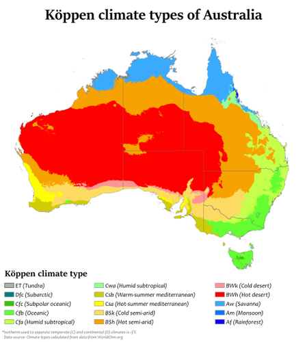
Central and Western Australia are sparsely populated. Large areas of the Northern Territory and the desert regions are uninhabited. Approximately 40 percent of Australia’s interior is desert, where Type B climates dominate. The large land mass can heat up during the summer months, triggering high temperatures. Low humidity allows heat to escape into the atmosphere after the sun goes down, so there is a wide temperature variation between day and night.
Along the northern coastal region there are more tropical type A climates. Closer to the equator and with the sea to moderate temperatures, the northern areas around Darwin and Cape York have little temperature variation. Temperatures in Darwin average about 90 °F in the summer and 86 °F in the winter. Spring monsoons bring additional rainfall from February to March.
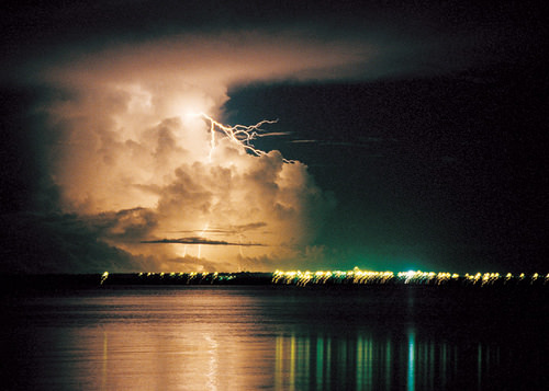 A wet season storm at night in Darwin, Australia.
Tasmania, Victoria, and the core region of the southeast have a more moderate and temperate type C climate. The main cities, such as Sydney, Melbourne, and Adelaide, are within this area. It is not surprising that there is a direct correlation between Type C climates and the major population areas. The Tropic of Capricorn cuts across the continent, indicating that the cities are not that far south of the tropics. Average winter temperatures in June and July do not usually fall below 50 °F and average summer temperatures in January and February remain around 70 °F. Since the seasons are reversed from that of the Northern Hemisphere, many Australians go to the beach for Christmas.
 Sydney Harbour seen from Sydney Harbour Bridge, Australia
Population, Urbanization, and the Core-Periphery Spatial Relationship
Australia is divided politically into six states and two territories. They are the Northern Territory, Australian Capital Territory, Western Australia, Tasmania, South Australia, Queensland, and New South Wales. Australian protectorates are composed of a number of small islands around Australia. Australian core areas are conducive to large human populations. To locate the core population areas in Australia, simply find the moderate Type C climates. Australia has two core regions. There is a small core region in the west, anchored by the city of Perth. Most of Australia’s people live in the large core region in the east along the coast. This region extends from Brisbane to Adelaide and holds most of the country’s population.
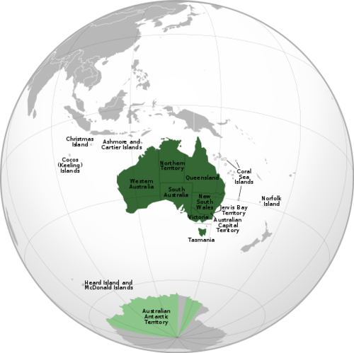 Australian States and Territories
| Flag | State/territory name | Abbreviation | Type | Capital (or largest settlement) |
Population |
|---|---|---|---|---|---|
|
|
New South Wales | NSW | State | Sydney | 7,704,300 |
|
|
Queensland | Qld | State | Brisbane | 4,827,000 |
|
|
South Australia | TO | State | Adelaide | 1,706,500 |
|
|
Tasmania | That | State | Hobart | 518,500 |
|
|
Victoria | Vic | State | Melbourne | 6,039,100 |
|
|
Western Australia | WA | State | Perth | 2,613,700 |
|
|
Australian Capital Territory | ACT | Territory | Canberra | 397,397 |
| Jervis Bay Territory | JBT | Territory | (Jervis Bay Village) | 391 | |
|
|
Northern Territory | NT | Territory | Darwin | 244,000 |
| Ashmore and Cartier Islands | External | (Offshore) | 0 | ||
| Australian Antarctic Territory | AAT | External | Davis Station | 1,000 | |
|
|
Christmas Island | External | Flying Fish Cove | 2,072 | |
|
|
Cocos (Keeling) Islands | External | West Island / Pulu Panjang | 596 | |
| Coral Sea Islands | External | (Willis Island) | 4 | ||
| Heard Island and McDonald Islands | HIMI | External | (Atlas Cove) | 0 | |
|
|
Norfolk Island | External | Kingston | 2,302 |
The total population of Australia in 2017 was approximately 23 million. There are more people living in Mexico City than in all of Australia. More than 90 percent of this population has European heritage, and most of this percentage is from the British Isles. English is the dominant language. Christianity is the dominant religion. The makeup of the people is a product of European colonialism and immigration.
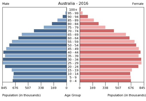
Age Structure of Australia: 0-14 years: 17.8% (male 2,122,139/female 2,012,670); 15-24 years: 12.79 percent (male 1,524,368/female 1,446,663); 25-54 years: 41.45 percent (male 4,903,130/female 4,725,976); 55-64 years: 11.83 percent (male 1,363,331/female 1,384,036); 65 years and over: 16.14 percent (male 1,736,951/female 2,013,149)
Only about two percent of the current population consists of Aboriginal people, the original people of Australia. Australia’s population has seen periodic growth spurts as waves of immigrants responded to national policies encouraging immigration. This was especially true after World War II. About 24 percent of the current population was born outside of Australia; most come from the United Kingdom, and another large percentage comes from New Zealand. Asian countries have also contributed to the Australian population, with measurable numbers of immigrants from China, Vietnam, and the Philippines. And lastly, people from Italy and India also make up a notable proportion of Australia’s immigrant population.
Australia’s population is not spread evenly across the landscape, since a large portion of the country is desert. The population is concentrated mostly in the urban areas. About 90 percent of the population live in cities, which are mostly in coastal areas. The largest city, Sydney, is often referred to as the New York of Australia. Sydney is positioned at the heart of the main core area, the state of New South Wales. To the south of Sydney is the Australian Capital Territory, home to the capital city of Canberra. Other major Australian cities include Melbourne, Perth, Adelaide, and Brisbane. Hobart is the largest city on the island of Tasmania and Darwin is the largest city in the Northern Territory.
| Rank | Cities | State/Territory |
June 2017 Census Population |
Percentage of national population (June 2017) |
|---|---|---|---|---|
| 1 | Sydney | New South Wales | 5,131,326 | 20.86% |
| 2 | Melbourne | Victoria | 4,850,740 | 19.72% |
| 3 | Brisbane | Queensland | 2,408,223 | 9.79% |
| 4 | Perth | Western Australia | 2,043,138 | 8.31% |
| 5 | Adelaide | South Australia | 1,333,927 | 5.42% |
| 6 | Gold Coast/Tweed Heads | Queensland/New South Wales | 693,321 | 2.70% |
| 7 | Newcastle/Maitland | New South Wales | 491,183 | 1.96% |
| 8 | Canberra/Queanbeyan | Australian Capital Territory/New South Wales | 447,457 | 1.82% |
| 9 | Sunshine Coast | Queensland | 375,399 | 1.32% |
| 10 | Wollongong | New South Wales | 299,203 | 1.22% |
All of the large cities of Australia—except the planned capital city of Canberra—are located on the coast. This pattern of urban distribution was a product of European colonial development. Most of Australia’s population lives in the two economic core regions, so Australia exhibits a distinct core-periphery spatial pattern. The core areas hold the power, wealth, and influence while the periphery region supplies all the food, raw materials, and goods needed in the core. Australia has never had a majority rural population since its Aboriginal times. There has been little rural-to-urban shift in Australia’s population.
English is the first language of the vast majority of the population. Recently, enacted policies and changing attitudes toward multiculturalism have spurred growth in the number of immigrants and their descendants who speak two languages fluently—English and the language of their birthplace or national heritage. Indigenous languages have not fared so well. As many as 300 indigenous languages were spoken by Aborigines before the Europeans arrived, and just a few hundred years later, that number now stands at about 70. Most aboriginal languages are in danger of dying out.
| Main languages | Australian English |
|---|---|
| Indigenous languages | Australian Aboriginal languages, Tasmanian languages, Torres Strait Island languages |
| Main immigrant languages | Mandarin (2.5%), Arabic (1.4%), Cantonese (1.2%), Vietnamese (1.2%), Italian (1.2%) |
Culture and Immigration
Until 1973, Australia had a collection of laws and policies known as the White Australia policy, which served to limit the immigration of nonwhite persons to Australia. While the White Australia policies limited immigration from some areas, other policies sought to expand immigration from the United Kingdom. Subsidies were offered to British citizens to relocate to Australia. Between 1830 and 1940, more than one million British citizens took advantage of the offer.
Recent census data indicate that 22.6 percent of the population identifies itself as Roman Catholic, and over 29 percent identify with other Christian faiths. Islam comprises 2.6 percent of the Australian population, followed by Buddhists at 2.4 percent and Hindus at 1.9%. Over 30 percent of Australians do not identify with any religion. Regular church attendance is claimed by at about 7.5 percent of the population. Despite modern Australia having been settled by the British, Australian law decrees that Australia will have no national religion and guarantees freedom of religion.
Sports are an important part of Australian culture, perhaps owing to a climate that allows for year-round outdoor activity. About one-fourth of the population is involved in some kind of organized sports team. Soccer is popular, rugby, and cricket are the most popular sports. The most popular spectator sport in Australia is Australian Rules Football, also known as Aussie Rules Football, or simply “footy.” This uniquely Australian game has codified rules that date back to 1858 and is a variant of football and rugby.
 A North East Australian Football League (NEAFL) match on July 4, 2015, at TIO Stadium in Darwin, Northern Territory.
Other forms of entertainment include television, film, and live performances of many kinds. Although Australia has a number of its own television stations, there are concerns that popular culture is beginning to be dominated by American influences. Australia’s large cities have extensive programs in the arts. Sydney is becoming a center for world-class performances in dance, opera, music, and theater.
Education is well-funded and internationally respected. School attendance is compulsory between the ages of 6 and 15, and the adult literacy rate has held steady at about 99 percent. Most students attend publicly funded schools, which are secular. Private schools, which charge tuition fees, do exist and are typically run by religious organizations, predominantly the Catholic Church.
Economic Geography
Most of Australia—especially the wide expanse of the arid interior known as the outback—has immense open spaces, agricultural potential or excellent resource extraction possibilities. The extensive grasslands support tens of millions of domesticated animals—mainly cattle and sheep—which accounts for up to one-fifth of the world’s wool production. Large agricultural businesses include thousands of acres under one operation.
The western sector of the Great Dividing Range in New South Wales is an excellent region for commercial grain operations. The coastal region in Queensland, since it is warmer and receives more rainfall, is good for sugarcane and similar crops. Sheep and cattle ranches are common in central Queensland and Western Australia. Various regions of southern Australia are excellent for grape and fruit production. Australian wine production has risen to compete with the US and European markets. Only the dry central desert regions in the center of the continent are not favorable for agriculture.
In the early portion of the 20th century, Australia gained enormous wealth by exporting food products to the rest of the world. This is still true, but the profit margin on food goods is no longer what it used to be. The country has had to look elsewhere to gain wealth.
Australia has excellent food production capabilities. It also has an excellent mineral resource base. Different types of minerals can be found in different regions throughout Australia. Western Australia has iron ore mines. The eastern region of Queensland and New South Wales has abundant coal reserves. Minerals such as zinc, copper, gold, silver, tungsten, and nickel can be found in various parts of the country, including Tasmania. Oil and gas fields can be found in the northwestern coastal waters and in the Tasman Sea east of Melbourne. The country is self-sufficient in natural gas but does have to import some petroleum products.
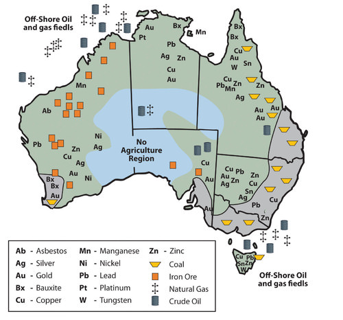
Australia does not export many manufactured goods. Its main exports are food and raw materials. Though Australia is a former British colony, Great Britain is not considered Australia’s largest trading partner. Australia is closer geographically to the Asian economic community than to the European Union. Japan has become Australia’s biggest trading partner. When Australia is viewed in the news, in television programs, and in Hollywood movies, it is portrayed as a country with a similar standard of living to the United States or Europe.
How do Australians have such a high standard of living if they don’t manufacture anything for export? To evaluate this, think about the size of the population of Australia and consider the distribution of wealth. They export an immense amount of raw materials and have a relatively small population to share the wealth.
As of the year 2002, tourism has become Australia’s number one means of economic income. From the Great Barrier Reef and the Gold Coast to the vast expanse of the outback, Australia has been marketing itself as an attractive place to visit with great success. Tourism from Japan provides a large percentage of tourist activity. Australia has moved through the initial stages of the index of economic development to become a society that is about 90 percent urban with small families and high incomes.
Mining and Aboriginal Lands
Territorial control of Australian lands has become a major issue in recent years. Large portions of Western Australia and the outback have traditionally been Aboriginal lands. European colonialism on the Australian continent displaced many of the native people. Large sections of land once used by the Aborigines were taken over by the government or by private interests. Large agricultural operations and mining operations have used the lands without adequate compensation to the Aboriginal people who once controlled them. Court rulings aimed at reparation for native people have had mixed results.
There are as many as 400 different groups of Aborigines currently in Australia that make up a total population of about 450,000. This is a small percentage of Australia’s population but involves a large part of the physical area of the country. Their land claims include all of the Northern Territory, a large portion of Western Australia, and parts of South Australia and Queensland. This is in addition to claims located within many urban areas, such as the largest city, Sydney.
Mining operations on Aboriginal lands have become highly regulated. Concerns have arisen that Australia’s extractive industries will diminish, causing a decline in the economy. The concern for the Aboriginal population has increased in the past few decades and the government has made attempts to mediate their political and economic issues as well as strengthen programs that address their social welfare.
Australia’s Future
The economic future of Australia is complex. Though tourism has become a viable means of providing income, Australia must import manufactured products that it does not produce locally, including electronic goods, computers, and automobiles. Import dependence has increased its trade deficit. Trade agreements and protectionism have become a part of the economic puzzle of how to sustain a competitive standard of living.
Australia is located next to the Asian realm. Its economy, culture, and future are becoming more Asian. Immigration has been an issue in that the government has always restricted immigration to ensure a European majority. Millions of Asian people would like to migrate to Australia to seek greater opportunities and advantages, but they are legally restricted. It is becoming more difficult for Australians to hold to their European connections with a growing Asian presence.
- Australia is an island continent that was home to aboriginal people before the British colonized it by first creating prison colonies for convicts from Great Britain.
- Australia is a relatively flat continent with low elevation highlands, including the Great Dividing Range along its eastern coast. The interior outback lacks precipitation and has numerous deserts.
- Two main core areas exist where Type C climates prevail and where most of the population lives: a large core area on the southeastern coast and a small core area around Perth on the western coast. The sparsely populated outback makes up the vast periphery, which has large amounts of mineral and agricultural resources.
- Aboriginal people were in Australia for 40,000 years. The British colonial activity didn’t heat up until the late 1700s. Today, most of the 22 million people are from the British Isles and Europe. Only about four hundred 50,000 Aborigines remain.
- Australia has few manufacturing enterprises for export profits. Tourism has become the number one method of gaining wealth, with the export of raw materials the second-largest method.
Vocabulary Terms
|
Aboriginal people |
an original inhabitant of Australia |
|
Cultural convergence |
The theory that two cultures will be more and more like each other as their interactions increase. Basically, the more that cultures interact, the more that their values, ideologies, behavior, arts, and customs will start to reflect each other. |
|
Cultural divergence |
Is the tendency for cultures to become dissimilar over time |
|
indigenous |
Originating or occurring naturally in a particular place; native |
|
Oceania |
A geographic region which includes Australasia, Melanesia, Micronesia, and Polynesia. Spanning the eastern and western hemispheres, Oceania covers an area of more than 3 million square miles and has a population of 40 million |
|
Colonial exploitation |
The national economic policy of conquering a country to exploit its population as labor and its natural resources as raw material |
|
Core-periphery spatial relationship |
Shows spatially how economic political, and cultural authority is dispersed in core or dominant regions and the surrounding peripheral and semi-peripheral regions |
|
Cultural attributes |
Characteristics that define a culture |
|
Scrublands |
A plant community characterized by vegetation dominated by shrubs, often also including grasses, herbs, and geophytes. Scrubland may occur naturally or may be the result of human activity. |
|
Great Barrier Reef |
The world’s largest coral reef system composed of over 2,900 individual reefs and 900 islands and stretching for over 1,400 miles. It is located in the Coral Sea, off the coast of Queensland, Australia. |
|
The Great Artesian Basin |
One of the largest underground fresh-water reservoirs in the world. It underlies 22% of Australia, occupying an area of over 1.7 million square kilometers beneath the arid and semi-arid parts of Queensland, New South Wales, South Australia, and the Northern Territory. |
Applying Knowledge
Interactive Notebook Activities
- Summarize the colonial exploitation and development of Australia.
- Describe the basic characteristics of Australia’s physical geography.
- Outline how the core-periphery spatial relationship applies to Australia.
- Describe the country’s general cultural attributes.
- Summarize the methods used for the country to gain national wealth.
Discussion and Study Questions
- Name the European country that colonized Australia. What was the original reason for colonizing Australia?
- What are Australia’s main political divisions? What is the vast interior called?
- What are some of Australia’s main physical features? How are they developed for tourism?
- What are the main climate types in Australia? How does climate relate to the population?
- What type of government does Australia have? What is its capital city? Who is the head of state?
- Outline the core-periphery relationship in Australia. What distinguishes the core areas?
- How does Australia compare with the Asian economic tigers? How do they support each other?
- How does Australia maintain a high standard of living when it exports a few manufactured products?
- What are Australia’s main exports? Who is their main trading partner?
- What stage is the country in with regard to the index of economic development?
Real-World Geography Exercise
Using Google Maps, locate each of the places on the list below. Next, choose one of these areas and create a SWAY or a PowerPoint presentation. Find important facts, maps, images and videos to use in your presentation. Be prepared to share your project.
- Adelaide
- Arafura Sea
- Australian Capital Territory
- Brisbane
- Canberra
- Cape York
- Coral Sea
- Darling-Murray River
- Darwin
- Gibson Desert
- Gold Coast
- Great Artesian Basin
- Great Australian Bight
- Great Barrier Reef
- Great Dividing Range
- Great Sandy Desert
- Great Victoria Desert
- Gulf of Carpentaria
- Hobart
- Melbourne
- New South Wales
- Northern Territory
- Outback
- Perth
- Queensland
- Sydney
- Simpson Desert
- South Australia
- Tasman Sea
- Tasmania
- Timor Sea
- Victoria
- Western Australia
Current Events
Top 20 Australian Baby Names That Have Nothing To Do With Kangaroos, Koalas, Or Vegemite
Australia Starts Importing U.S. Light Crude
Health Professionals Threatened With Disciplinary Action If They Spread Anti-Vaccination Messages
Videos for Geography Enrichment
Helpful Websites for the Study of Geography
Canadian Encyclopedia is an encyclopedia funded by the Canadian government covering all branches of knowledge. Their scholarly collection includes interactive materials.
CIA World Factbook provides information on the people, history, government, economy, energy, geography, communications, transportation, military, and transnational issues for the world's entities.
Congress.gov is a US government website where you can find federal legislation, past and present, as well as information about the US legal system.
Drug Enforcement Administration (DEA) is a government agency website that provides current news, resources, topics of interest, information about drugs, careers in the DEA, and a tip hotline.
Library of Congress is the largest library in the world and provides manuscripts, files, information, pictures, and videos.
NASA Earth Observatory (NEO) is a US government agency website that allows users to search for and retrieve satellite images of Earth.
National Archives is a US government website that provides historical documents, photos, records, publications, and educator resources.
National Oceanic and Atmospheric Association (NOAA) is a US government agency website that provides weather-related information and ocean research.
National Map is a website by the United States Geological Survey and other federal, state, and local agencies that delivers topographic information for the United States.
NationMaster is a massive central data source and a handy way to graphically compare nations.
Real-Time World Air Quality Index is a website that measures most locations in the world for air pollution in real time.
StateMaster is a unique statistical database, which allows you to research and compare a multitude of different data on US states.
United Nations (UN) is an international organization founded in 1945 and made up of 193 member states. The UN maintains international peace and security, protects human rights, delivers humanitarian aid, promotes sustainable development, and upholds international law.
United States Census Bureau is a US government agency that provides a population clock, data, surveys, statistics, a library with information and infographics, news about the economy, and much more.
United States Geological Survey (USGS) is a US government agency website that provides scientific information about the natural hazards that threaten lives, the natural resources we rely on, the health of our ecosystems and environment, and the impacts of climate and land-use change.
Whitehouse.gov is a US government website that provides the latest presidential news, information about the budget, policy, defense, and many more topics.
World Health Organization (WHO) is under the United Nations and provides leadership on matters critical to health, shapes the research agenda on health, and monitors the health situation and assessing health trends around the world. Their website provides information on the state of health around the world, outbreaks, current health news, and more.
World Trade Organization (WTO) is an intergovernmental organization that regulates international trade. The website provides information on the history of the multilateral trading system, featured videos, news and events, trade topics, and more.


