6.29: Biomes and Climate
- Page ID
- 12127
\( \newcommand{\vecs}[1]{\overset { \scriptstyle \rightharpoonup} {\mathbf{#1}} } \)
\( \newcommand{\vecd}[1]{\overset{-\!-\!\rightharpoonup}{\vphantom{a}\smash {#1}}} \)
\( \newcommand{\dsum}{\displaystyle\sum\limits} \)
\( \newcommand{\dint}{\displaystyle\int\limits} \)
\( \newcommand{\dlim}{\displaystyle\lim\limits} \)
\( \newcommand{\id}{\mathrm{id}}\) \( \newcommand{\Span}{\mathrm{span}}\)
( \newcommand{\kernel}{\mathrm{null}\,}\) \( \newcommand{\range}{\mathrm{range}\,}\)
\( \newcommand{\RealPart}{\mathrm{Re}}\) \( \newcommand{\ImaginaryPart}{\mathrm{Im}}\)
\( \newcommand{\Argument}{\mathrm{Arg}}\) \( \newcommand{\norm}[1]{\| #1 \|}\)
\( \newcommand{\inner}[2]{\langle #1, #2 \rangle}\)
\( \newcommand{\Span}{\mathrm{span}}\)
\( \newcommand{\id}{\mathrm{id}}\)
\( \newcommand{\Span}{\mathrm{span}}\)
\( \newcommand{\kernel}{\mathrm{null}\,}\)
\( \newcommand{\range}{\mathrm{range}\,}\)
\( \newcommand{\RealPart}{\mathrm{Re}}\)
\( \newcommand{\ImaginaryPart}{\mathrm{Im}}\)
\( \newcommand{\Argument}{\mathrm{Arg}}\)
\( \newcommand{\norm}[1]{\| #1 \|}\)
\( \newcommand{\inner}[2]{\langle #1, #2 \rangle}\)
\( \newcommand{\Span}{\mathrm{span}}\) \( \newcommand{\AA}{\unicode[.8,0]{x212B}}\)
\( \newcommand{\vectorA}[1]{\vec{#1}} % arrow\)
\( \newcommand{\vectorAt}[1]{\vec{\text{#1}}} % arrow\)
\( \newcommand{\vectorB}[1]{\overset { \scriptstyle \rightharpoonup} {\mathbf{#1}} } \)
\( \newcommand{\vectorC}[1]{\textbf{#1}} \)
\( \newcommand{\vectorD}[1]{\overrightarrow{#1}} \)
\( \newcommand{\vectorDt}[1]{\overrightarrow{\text{#1}}} \)
\( \newcommand{\vectE}[1]{\overset{-\!-\!\rightharpoonup}{\vphantom{a}\smash{\mathbf {#1}}}} \)
\( \newcommand{\vecs}[1]{\overset { \scriptstyle \rightharpoonup} {\mathbf{#1}} } \)
\(\newcommand{\longvect}{\overrightarrow}\)
\( \newcommand{\vecd}[1]{\overset{-\!-\!\rightharpoonup}{\vphantom{a}\smash {#1}}} \)
\(\newcommand{\avec}{\mathbf a}\) \(\newcommand{\bvec}{\mathbf b}\) \(\newcommand{\cvec}{\mathbf c}\) \(\newcommand{\dvec}{\mathbf d}\) \(\newcommand{\dtil}{\widetilde{\mathbf d}}\) \(\newcommand{\evec}{\mathbf e}\) \(\newcommand{\fvec}{\mathbf f}\) \(\newcommand{\nvec}{\mathbf n}\) \(\newcommand{\pvec}{\mathbf p}\) \(\newcommand{\qvec}{\mathbf q}\) \(\newcommand{\svec}{\mathbf s}\) \(\newcommand{\tvec}{\mathbf t}\) \(\newcommand{\uvec}{\mathbf u}\) \(\newcommand{\vvec}{\mathbf v}\) \(\newcommand{\wvec}{\mathbf w}\) \(\newcommand{\xvec}{\mathbf x}\) \(\newcommand{\yvec}{\mathbf y}\) \(\newcommand{\zvec}{\mathbf z}\) \(\newcommand{\rvec}{\mathbf r}\) \(\newcommand{\mvec}{\mathbf m}\) \(\newcommand{\zerovec}{\mathbf 0}\) \(\newcommand{\onevec}{\mathbf 1}\) \(\newcommand{\real}{\mathbb R}\) \(\newcommand{\twovec}[2]{\left[\begin{array}{r}#1 \\ #2 \end{array}\right]}\) \(\newcommand{\ctwovec}[2]{\left[\begin{array}{c}#1 \\ #2 \end{array}\right]}\) \(\newcommand{\threevec}[3]{\left[\begin{array}{r}#1 \\ #2 \\ #3 \end{array}\right]}\) \(\newcommand{\cthreevec}[3]{\left[\begin{array}{c}#1 \\ #2 \\ #3 \end{array}\right]}\) \(\newcommand{\fourvec}[4]{\left[\begin{array}{r}#1 \\ #2 \\ #3 \\ #4 \end{array}\right]}\) \(\newcommand{\cfourvec}[4]{\left[\begin{array}{c}#1 \\ #2 \\ #3 \\ #4 \end{array}\right]}\) \(\newcommand{\fivevec}[5]{\left[\begin{array}{r}#1 \\ #2 \\ #3 \\ #4 \\ #5 \\ \end{array}\right]}\) \(\newcommand{\cfivevec}[5]{\left[\begin{array}{c}#1 \\ #2 \\ #3 \\ #4 \\ #5 \\ \end{array}\right]}\) \(\newcommand{\mattwo}[4]{\left[\begin{array}{rr}#1 \amp #2 \\ #3 \amp #4 \\ \end{array}\right]}\) \(\newcommand{\laspan}[1]{\text{Span}\{#1\}}\) \(\newcommand{\bcal}{\cal B}\) \(\newcommand{\ccal}{\cal C}\) \(\newcommand{\scal}{\cal S}\) \(\newcommand{\wcal}{\cal W}\) \(\newcommand{\ecal}{\cal E}\) \(\newcommand{\coords}[2]{\left\{#1\right\}_{#2}}\) \(\newcommand{\gray}[1]{\color{gray}{#1}}\) \(\newcommand{\lgray}[1]{\color{lightgray}{#1}}\) \(\newcommand{\rank}{\operatorname{rank}}\) \(\newcommand{\row}{\text{Row}}\) \(\newcommand{\col}{\text{Col}}\) \(\renewcommand{\row}{\text{Row}}\) \(\newcommand{\nul}{\text{Nul}}\) \(\newcommand{\var}{\text{Var}}\) \(\newcommand{\corr}{\text{corr}}\) \(\newcommand{\len}[1]{\left|#1\right|}\) \(\newcommand{\bbar}{\overline{\bvec}}\) \(\newcommand{\bhat}{\widehat{\bvec}}\) \(\newcommand{\bperp}{\bvec^\perp}\) \(\newcommand{\xhat}{\widehat{\xvec}}\) \(\newcommand{\vhat}{\widehat{\vvec}}\) \(\newcommand{\uhat}{\widehat{\uvec}}\) \(\newcommand{\what}{\widehat{\wvec}}\) \(\newcommand{\Sighat}{\widehat{\Sigma}}\) \(\newcommand{\lt}{<}\) \(\newcommand{\gt}{>}\) \(\newcommand{\amp}{&}\) \(\definecolor{fillinmathshade}{gray}{0.9}\)
What do temperature, wind, and rain, have in common?
They are all part of climate, the statistical summary of temperature, humidity, atmospheric pressure, wind, rainfall, other meteorological measurements in a given region over long periods. In other words, is it dry or wet, hot or cold, or humid? And it is these abiotic factors that help determine the nature of a biome.
Terrestrial Biomes
If you look at the two pictures in Figure below, you will see very few similarities. The picture on the left shows a desert in Africa. The picture on the right shows a rainforest in Australia. The desert doesn’t have any visible plants, whereas the rainforest is densely packed with trees. What explains these differences?
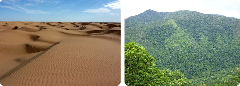 Sahara Desert in northern Africa (left). Rainforest in northeastern Australia (right). Two very different biomes are pictured here. A biome is a group of similar ecosystems with the same general abiotic factors and primary producers. Both are found at roughly the same distance from the equator.
Terrestrial biomes include all the land areas on Earth where organisms live. The distinguishing features of terrestrial biomes are determined mainly by climate. Terrestrial biomes include tundras, temperate forests and grasslands, chaparral, temperate and tropical deserts, and tropical forests and grasslands.
Terrestrial Biomes and Climate
Climate is the average weather in an area over a long period of time. Weather refers to the conditions of the atmosphere from day to day. Climate is generally described in terms of temperature and moisture.
Temperature falls from the equator to the poles. Therefore, major temperature zones are based on latitude. They include tropical, temperate, and arctic zones (see Figure below). However, other factors besides latitude may also influence temperature. For example, land near the ocean may have cooler summers and warmer winters than land farther inland. This is because water gains and loses heat more slowly than does land, and the water temperature influences the temperature on the coast. Temperature also falls from lower to higher altitudes. That’s why tropical zone mountain tops may be capped with snow.
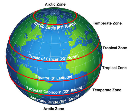 Temperature zones are based on latitude. What temperature zone do you live in?
In terms of moisture, climates can be classified as arid (dry), semi-arid, humid (wet), or semi-humid. The amount of moisture depends on both precipitation and evaporation. Precipitation increases moisture. Evaporation decreases moisture.
- The global pattern of precipitation is influenced by movements of air masses. For example, there is a global belt of dry air masses and low precipitation at about 30° N and 30° S latitude.
- Precipitation is also influenced by temperature. Warm air can hold more moisture than cold air, so tropical areas receive more rainfall than other parts of the world.
- Nearness to the ocean and mountain ranges may also influence the amount of precipitation an area receives. This is explained in Figure below.
- Evaporation of moisture is greatest where it is hot and sunny. Therefore, cold climates with low precipitation may not be as dry as warm climates with the same amount of precipitation.
- Moist air from the ocean rises up over the mountain range.
- As the air rises, it cools and its water vapor condenses. Precipitation falls on the windward side of the mountain range.
- The air is dry when it reaches the leeward side of the mountain range, so there is little precipitation there. This creates a “rain shadow.”
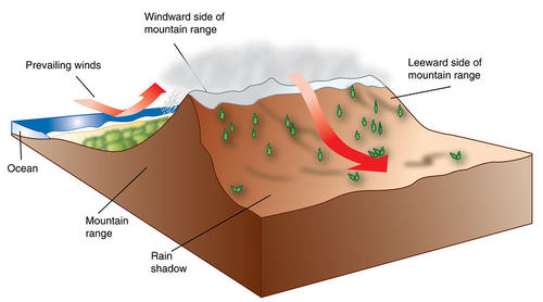 This diagram shows how precipitation is affected by the ocean and a mountain range.
Climate and Plant Growth
Plants are the major producers in terrestrial biomes. They have five basic needs: air, warmth, sunlight, water, and nutrients. How well these needs are met in a given location depends on the growing season and soil quality, both of which are determined mainly by climate.
- The growing season is the period of time each year when it is warm and wet enough for plants to grow. The growing season may last all year in a hot, wet climate but just a few months in a cooler or drier climate.
- Plants grow best in soil that contains plenty of nutrients and organic matter. Both are added to soil when plant litter and dead organisms decompose. Decomposition occurs too slowly in cold climates and too quickly in hot, wet climates for nutrients and organic matter to accumulate. Temperate climates usually have the best soil for plant growth.
Climate and Biodiversity
Because climate determines plant growth, it also influences the number and variety of other organisms in a terrestrial biome. Biodiversity generally increases from the poles to the equator. It is also usually greater in more humid climates. This is apparent from the desert and rainforest biomes pictured in Figure above.
Climate and Adaptations
Organisms evolve adaptations that help them survive in the climate of the biome where they live. For example, in biomes with arid climates, plants may have special tissues for storing water (see Figure below). The desert animals pictured in Figure below also have adaptations for a dry climate.
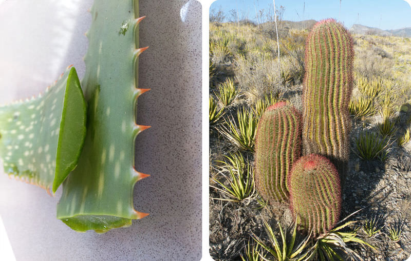 The aloe plant on the left stores water in its large, hollow leaves. The cactus plant on the right stores water in its stout, barrel-shaped stems.
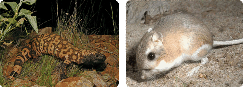 The Gila monster’s fat tail is an adaptation to its dry climate. It serves as a storage depot for water. The kangaroo rat has very efficient kidneys. They produce concentrated urine, thus reducing the amount of water lost from the body.
In biomes with cold climates, plants may adapt by becoming dormant during the coldest part of the year. Dormancy is a state in which a plant slows down cellular activities and may shed its leaves. Animals also adapt to cold temperatures. One way is with insulation in the form of fur and fat. This is how the polar bears in Figure below stay warm.
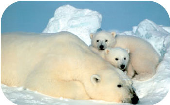 Thick fur and a layer of blubber keep polar bears warm in their Arctic ecosystem. Why do you think their fur is white? Why might it be an adaptation in an Arctic biome?
Summary
- Terrestrial biomes are determined mainly by climate.
- Climate influences plant growth, biodiversity, and adaptations of land organisms.
Review
1. What is climate? How does it differ from weather?
2. What is a rain shadow?
3. What is a growing season? How does climate influence plant growth?
4. Describe the relationship between climate and biodiversity.
5. Compare the data for Seattle and Denver in Table below. Seattle is farther north than Denver. Why is Seattle warmer?
| City, State | Latitude (°N) | Altitude (ft above sea level) | Location (relative to ocean) | Average Low Temperature in January (°F) |
|---|---|---|---|---|
| Seattle, Washington | 48 | 429 | Coastal | 33 |
| Denver, Colorado | 41 | 5183 | Interior | 15 |
| Image | Reference | Attributions |
 |
[Figure 1] | Credit: U.S. Fish and Wildlife Service Source: alaska.fws.gov/aba/budget/index.htm License: Public Domain |
 |
[Figure 2] | Credit: Desert: Flickr:wonker; Rainforest: User:Tim35/Wikipedia Source: Desert: http://www.flickr.com/photos/wonker/4300437105/ ; Rainforest: commons.wikimedia.org/wiki/File:Rainforrest_between_Kuranda_and_Cairns ; _North_East_Queensland.jpg License: Desert: CC BY 2.0; Rainforest: Public Domain |
 |
[Figure 3] | Credit: Laura Guerin, using globe graphic courtesy of the Defense Institute of Security Assistance Management Source: CK-12 Foundation (globe graphic: commons.wikimedia.org/wiki/File:Globe_Atlantic.svg) License: CC BY-NC 3.0; Globe graphic: Public Domain |
 |
[Figure 4] | Credit: CK-12 Foundation Source: CK-12 Foundation License: CC BY-NC 3.0 |
 |
[Figure 5] | Credit: Aloe: Rae Allen; Cactus: Amante Darmanin Source: Aloe: http://www.flickr.com/photos/raeallen/7049539727/ ; Cactus: http://www.flickr.com/photos/amantedar/5699827213/ License: CC BY 2.0 |
 |
[Figure 6] | Credit: Gila monster: David Mark; Kangaroo rat: U.S. Fish and Wildlife Service Source: Gila monster: pixabay.com/en/reticulate-gila-monster-animal-86618/ ; Kangaroo rat: commons.wikimedia.org/wiki/File:Kangaroo-rat.jpg License: Public Domain |
 |
[Figure 7] | Credit: U.S. Fish and Wildlife Service Source: alaska.fws.gov/aba/budget/index.htm License: Public Domain |

